Strong winds spread numerous wildfires in Oregon and Washington

An unprecedented number of fires and acres have burned in recent days

September 8, 2020 | 9:23 p.m. PDT

satellite photo fires smoke Washington, Oregon, and California
GOES-17 photo of smoke from wildfires in Washington, Oregon, and California at 5:56 p.m. PDT Sept. 8, 2020.

The number of wildfires and acres burning in Washington and Oregon are reaching a level that is close to unprecedented in recent memory.

Tuesday afternoon the western one-quarter of Oregon was inundated with dense smoke from multiple fires south of Portland and mostly east of Interstate 5. Strong winds are turning small fires that were ignited weeks ago in Marion County, Oregon into major incidents as law enforcement officers and firefighters try to stay ahead of the fires evacuating residents in their paths.

map wildfires in Washington and Oregon
Map showing heat detected by satellites on wildfires in Washington and Oregon at 4:18 p.m. PDT September 8, 2020.

Thousands of Oregonians were under evacuation orders Tuesday. OPG.org reported that officials said they were so focused on protecting lives and property that suppressing the blazes consuming hundreds of thousands of acres would have to wait. “Our number one priority is evacuation and basic life safety,” said Mariana Ruiz-Temple, chief deputy state fire marshal. “This wind event does not give us the opportunity to really get in there and fight fire how we might fight fire in previous events.”

The Glendower Fire started north of Ashland, Oregon then spread northwest along the Interstate 5 corridor into Medford. Much of the city is under evacuation orders and multiple structures have burned. (More information about the Glendower Fire, including a map.)
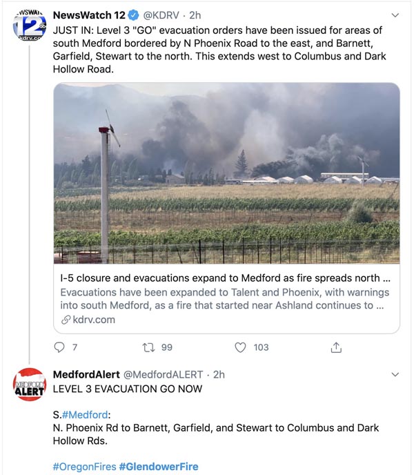
Glendowner Fire Oregon Medford
Tweet at 7:04 p.m. PDT Sept 8, 2020.

Strong winds accompanying a cold front was the primary force responsible for the rapid spread of the fires, but some of the driest conditions seen in decades led to low moisture content in vegetation that made large quantities of fuel available to quickly ignite.
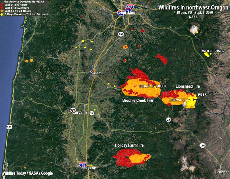
map wildfires in northwest Oregon
Map showing heat detected by satellites on wildfires in northwest Oregon, south of Portland at 4:18 p.m. PDT September 8, 2020.

The New York Times reported the National Weather Service on Tuesday placed Northwest and southwestern Oregon under an extreme fire danger warning, the first time southern Oregon has been the subject of such a warning, according to the Oregon Climate Office. The Oregon Department of Corrections evacuated 1,450 inmates from three prisons east of Salem.

The New York Times:

Gov. Jay Inslee of Washington said on Tuesday that an estimated 330,000 acres had burned across the state on Monday, more than what burned in each of the last 12 fire seasons. “The devastation is all over our state,” Mr. Inslee said in a news briefing.

One of the smaller fires in Washington, relatively speaking,  wiped out about 80 percent of the structures in Malden, a town of 200 people south of Spokane. Officials said the buildings that burned included the fire station, post office, city hall, and the library.

Three of the largest blazes in Washington are Cold Springs south of Omak (163,000 acres), Pearl Hill east of Brewster (174,000 acres), and Evans Canyon north of Yakima (75,817 acres). The Pearl Hill fire reportedly burned 170,000 acres within 24 hours.
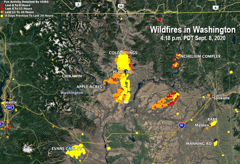
map fires Washington
Map showing heat detected by satellites on wildfires in Washington at 4:18 p.m. PDT September 8, 2020.

Cold Springs Fire burns hundreds of acres west of Boulder, Colorado

(Originally published at 12:18 MDT July 11, 2016)

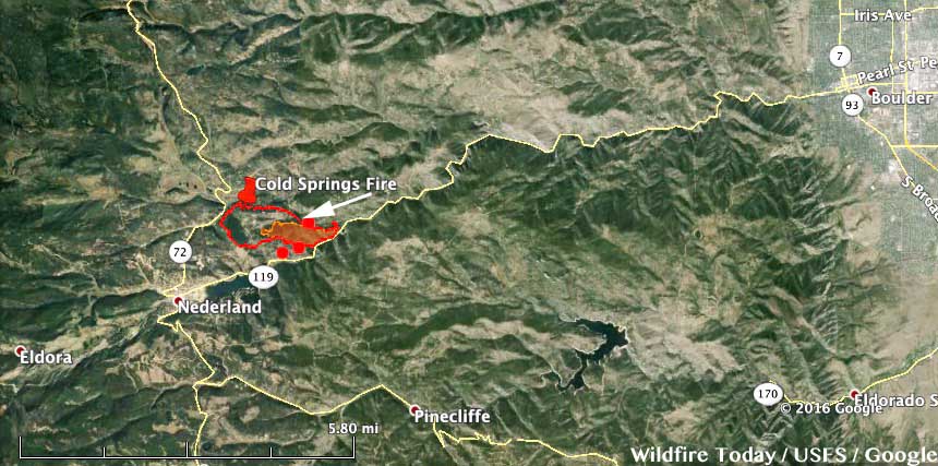
Cold Springs Fire map
Map showing the perimeter of the Cold Springs Fire at 1 a.m. MDT July 11, 2016. Click to enlarge.

The Cold Springs Fire has caused evacuations of about 2,000 residents near Nederland, Colorado, 10 miles west of Boulder. The fire, now 606 acres, started at about 1:30 p.m. on July 9 from an escaped campfire. Three transients were camping on private property and failed to extinguish the campfire they had Thursday night, according to the Boulder County Sheriff personnel, who arrested two of the three people Sunday, Jimmy Andrew Suggs, 28, and Zackary Ryan Kuykendall, 26, both of Vinemont, Alabama.

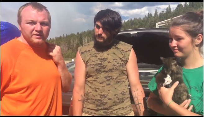
The Daily Camera interviewed the campers before they were arrested for fourth-degree arson, a Class 4 felony.

Cold Springs Fire
Screen shot from the Daily Camera interview.
Booking photos
Booking photos of Jimmy Andrew Suggs (left), 28, and Zackary Ryan Kuykendall (right), 26. Photo by Boulder County Sheriff’s Office.

On Sunday strong winds pushed the Cold Springs Fire toward Highway 119 and Boulder Creek Canyon, but firefighters worked overnight to construct fire lines and protect newly-threatened homes. Two very small spot fires on the south side of Boulder Creek Canyon were fully contained. At least 17 engines crews and four 20-person Hotshot crews worked overnight to build fire lines from Highway 119 along the fire’s edge. Crews also conducted burnout operations along Highway 119 to strengthen fire lines.

A damage assessment team confirmed on Monday that five homes have been destroyed.

Aircraft dropped 85,206 gallons of retardant on Saturday and 84,555 gallons on Sunday.

The weather forecast for the fire area on Monday could present problems for firefighters. It predicts 10 to 18 mph west winds gusting at 20 to 30 mph and a relative humidity of 16 percent. Conditions will be more benign on Tuesday.

Rocky Mountain Incident Management Team 2 with Incident Commander Shane Greer assumed command of the fire at 8:30 p.m. Sunday.

Weather Cold Springs Fire 7-11-2016

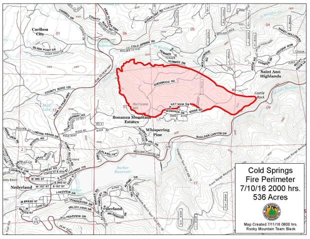
Map Cold Springs Fire
Map of the Cold Springs Fire at 8 p.m. MDT July 10, 2016.

Thanks and a tip of the hat go out to Jeffrey.