Update on Lower North Fork fire in Colorado, March 29

UPDATE at 7:56 p.m. MT, March 29

The Jefferson County Sheriff’s Office has posted the much-requested “current verified list of structures damaged by the Lower North Fork fire”, as well as a map. All local home owners with confirmed damaged properties have been escorted to their property by the Jefferson County Sheriff’s Office. There are two homeowners who have not made it back to their property because they are coming from out of the area.

There was no perimeter growth today. The size remains at 4,140 acres and they are calling it 45% contained.

============================================================

Original post, at 8:25 a.m. MT, March 29

As of Thursday morning, the Lower North Fork fire southeast of Conifer, Colorado is 15% contained and has burned 4,140 acres. The number of homes damaged or destroyed remains at 27. The owners of 26 of the structures have been notified. Rich Harvey’s Type 1 Incident Management Team assumed command of the fire at 6:00 a.m. today. The local Type 3 IMTeam will continue to work with the Type 1 team.

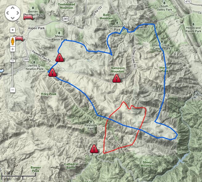
The map of the Lower North Fork fire below shows the perimeter (in red) as of 9:39 Wednesday night.

Map Lower North Fork Fire 2139 3-28-2012
Map of Lower North Fork Fire. The blue line is the evacuation zone. The red line is the fire perimeter at 9:39 p.m. 3-28-2012. Map provided by Jefferson County Sheriff's Office

On Wednesday there were two large air tankers assigned, P2Vs, Tankers #44 and #45, but they were removed from the fire late in the afternoon and redeployed to the Apple fire south of Custer, South Dakota. (We were at the Apple fire yesterday.) There will be four National Guard Blackhawk helicopters assigned to the Lower North Fork fire today. Four helicopters dropped 49,000 gallons of water yesterday.

Residents seeking information about the status of their property within the fire evacuation zone may come to the Conifer High School, but the school is closed to the general public.

With the apparent cause of the fire being an escaped prescribed fire that was managed by the Colorado Forest Service, on Wednesday Deputy State Forester Joe Duda issued a statement that reads in part:

We want to express our deepest sympathy to those who have lost loved ones and those who have lost property, and we hope for the safety of crews as they continue to fight the fire.

On Wednesday the governor of Colorado suspended the use of prescribed burns by state agencies.

It is very early in the year, and early in the wildfire season, but already firefighters are competing for aerial and hand crew resources. There are not enough to go around, and they are not deployed where the fires are occurring. This is due in part to the diminishing budgets of the firefighting agencies, translated as fewer firefighters, and mismanagement of the federal air tanker fleet.

Other articles on Wildfire Today about the Lower North Fork fire:

“I’m stuck in my vehicle … and there’s fire all over”

Four Jefferson County Deputy Sheriff officers were trapped in the Lower North Fork wildfire on March 26, 2011, southwest of Denver, but they escaped eventually, unhurt. This is an audio recording of some of the radio traffic from that incident, courtesy of 9news who got it from a scanner feed.

Click on the green arrow to listen to the recording.

More information about the Lower North Fork fire.

Update on Lower North Fork fire in Colorado

Lower North Fork Fire
Lower North Fork Fire. Credit: Jefferson County Sheriff's Office

(We will update this throughout the day on March 28 as developments occur.)

UPDATE at 12:30 p.m. MT, March 28, 2012

The reported size of the fire has been changed from 4,500 to 3,790 acres. This latest size was calculated from an infrared mapping flight that occurred at 10:30 p.m. on March 27.

The Jefferson County Sheriff’s office has reduced the number of damaged structures from 28 to 27. One of the recorded addresses was not accurate.

We have an audio recording of radio traffic from an incident that occurred on March 26 on the fire when four Jefferson County Sheriff officers were entrapped in the fire. They escaped unhurt, but the audio is gripping.

The Denver Post has some fascinating video that was shot by residents driving out of the fire. They said they did not receive a reverse 911 phone call warning.

=================================================

UPDATE at 9:23 a.m. March 28, 2012

The Jefferson County Sheriff’s Office has updated their map of the fire with data from 8:20 p.m., March 27. The fire perimeter in red. The blue line is the evacuation area as of 2:00 p.m. on March 27. We expect they will give us an updated acreage later.

Map Lower North Fork Fire 2030 3-27-2012
Map Lower North Fork Fire 8:30 p.m., 3-27-2012. Jefferson County Sheriff's Office

==============================================================

UPDATE at 8:45 a.m. March 28, 2012:

The Jefferson County Sheriff’s Office released some updated information at 8:30 a.m. on Wednesday:

Overnight the fire was relatively stable. Fire crews made progress through the night in protecting structures. Today’s strategy is to gain containment around the fire while continuing to protect structures.

Today’s fire behavior is expected to be similar to yesterday but with slightly higher winds. The winds could result in more robust fire activity. The fire will also most likely become more intense as the temperature rises throughout the day. The fire has continued to exhibit a tendency to start spot fires in a wide area.

[…]

The Jefferson County Sheriff’s Office will continue to man road blocks around the fire perimeter. At this time we are not allowing anyone back into the evacuated regions.

The Sheriff’s Office said the estimated size is still 4,500 acres and that 28 structures have been damaged.

===========================================================

(Original  post at 7:30 a.m. MT, March 28.)

The Lower North Fork fire that is southwest of Denver and seven miles southeast of Conifer, Colorado, was relatively quiet during the night. The last official acreage that was released by the Jefferson County Sheriff’s Office for the wildfire was 4,500, and they reported that 23 homes have been damaged. An elderly couple was found dead near their home and one resident within the burn area is missing.

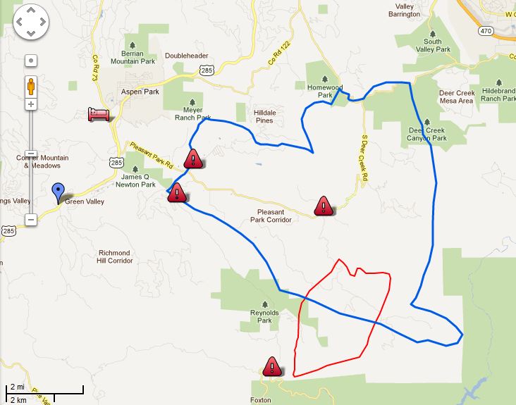
The map of the fire shows the fire perimeter in red, as of 11:00 p.m. on March 26. The blue line is the evacuation area as of 2:00 p.m. on March 27. We will provide an updated map as more information is provided.

Map Lower North Fork Fire 732 am 3-28-2012
Map Lower North Fork Fire. Jefferson County Sheriff's Office

The firefighters’ strategy on Wednesday is to switch from point protection to constructing fireline to begin containment of the fire. They had hoped to do that on Tuesday, but the weather and fire behavior did not cooperate, pushing them back into a defensive and structure protection mode. Containment is still listed at zero percent, and 900 homes are still under a mandatory evacuation order. On Wednesday three air tankers (two P2Vs and one single engine air tanker) and four helicopters (including two National Guard Blackhawks) will be working on the fire. More aircraft are on order.

The Rocky Mountain Area Coordination Center reported Wednesday morning that Rich Harvey’s Type 1 Incident Management Team arrived and in-briefed at 8:00 p.m. on Tuesday and will assume command at end of the shift today. The RMACC says 3,790 acres have burned. This reduction in size is probably due to more accurate mapping as a result of the aircraft that Tuesday night used infrared equipment to determine the fire perimeter.

On Tuesday the Colorado State Forest Service released a statement saying a prescribed fire they ignited on Wednesday, March 21, escaped control on Monday, and investigations are underway to determine the cause of the Lower North Fork fire. The Denver Post earlier on Tuesday quoted Jacki Kelley, a Jefferson County Sheriff’s Office spokeswoman, as saying the fire originated from a controlled burn conducted by the Colorado Forest Service.

This first video is from a 6:00 a.m. newscast on March 27.

The video below is from March 26.

9news.com occasionally has live video reports about the fire.

Read Wildfire Today’s March 27 coverage of the Lower North Fork fire. and the March 29 article.

Colorado fire update: 2 fatalities; 16 structures burn; fire map

Map Lower North Fork Fire 0900 3-27-2012
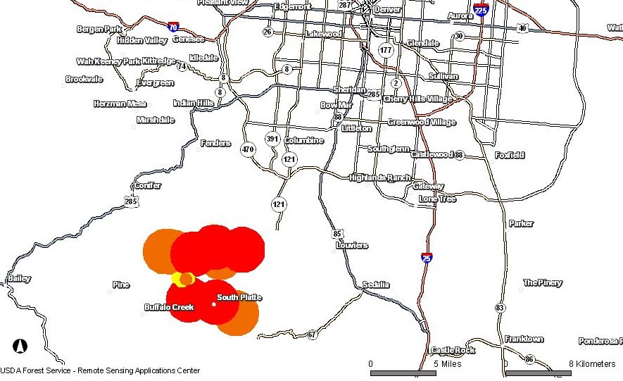
Map showing heat on the Lower North Fork Fire detected by satellites, March 27, 2012

(Read our March 28 update on the Lower North Fork fire and our March 29 update.)

UPDATE at 5:00 p.m. MT, 3-27-2012

The Jefferson County Sheriff’s Office has provided additional information about the Lower North Fork Fire:

  • 23 homes have been damaged by the fire.
  • 4,500 acres have burned
  • Two air tankers are working the fire: a single engine air tanker and a large P2V. Two military helicopters are also assigned.
  • Increased fire activity today convinced the incident management team to issue a pre-evacuation notice to an additional 6,500 homes north and east of the fire.
  • 200 firefighters are on scene.
  • Containment is at 0%. Due to the fire behavior, firefighters had to back off from their aggressive strategy this morning, to more of a defensive strategy emphasizing structure protection.
  • The Type 1 Incident Management Team has arrived. There is no word yet on when they will assume command. Our best guess at Wildfire Today is sometime on Wednesday.

=============================================================

UPDATE at 3:25 p.m. MT, 3-27-2012:

The Jefferson County Coroner’s Office has identifed the two fatalities from the Lower North Fork Fire as a husband and wife, Samuel Lucas, 77, and Linda Lucas, 76.

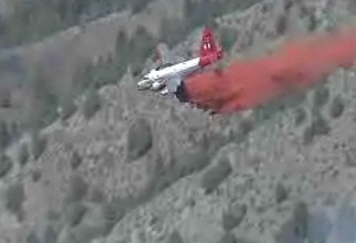
Air Tanker 44 drop 312 pm 3-27-2012
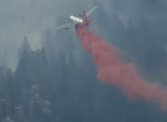
Air Tanker 44 dropping at 3:12 pm 3-27-2012, on the Lower North Fork Fire. 9News

UPDATE AT 2:24 p.m., March 27, 2012

The Jefferson County Sheriff’s Department has updated the map of the Lower North Fork fire. The blue line is the evacuation Area as of 3/27/2012 at 2:00 p.m. This evacuation zone is the original area and does not include the pre-evacuation notice to 6,500 homes located in regions north of the existing evacuation area. The additional pre-evacuation notice was sent out because “current weather conditions have caused the fire to act in an erratic manner which may threaten those 6500 homes”.

Map Lower North Fork Fire 220 pm 3-27-2012
Map, Lower North Fork Fire, updated at 2:20 p.m. 3-27-2012. By Jefferson County Sheriffs Office

=============================================================

UPDATE at 12:33 p.m. MT, March 27, 2012

As the temperature rises and the humidity decreases, activity on the fire is picking up. At least two air tankers are actively dropping retardant on the fire, a Single Engine Air Tanker, and Tanker 44, the P2V which is the tanker than ran off the end of the runway at Rocky Mountain Metro Airport in 2010 after its brakes failed. The aircraft was repaired at the airport and has been stationed there for the last week or so. Two National Guard helicopters are enroute from Buckley Air Force Base to start dropping water.

Lower North Fork fire, 4:00 p.m, 3-26-2012
Lower North Fork fire, 4:00 p.m, 3-26-2012. Photo provided by Jefferson County Sheriffs Office
Tanker 44 drop 1231 pm 3-27-2012
Tanker 44 dropping on the Lower North Fork Fire at 12:31 p.m., 3-27-2012. Credit: 9News

Continue reading “Colorado fire update: 2 fatalities; 16 structures burn; fire map”

Monday wildfire one-liners, March 26, 2012

Screen grab from report about Colorado wildfire conditions
Screen grab from CBS Denver report about Colorado wildfire conditions

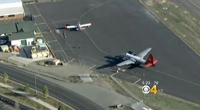
Excellent photos of a P2V and an Air Tractor 802A at Jeffco Air Tanker Base in Colorado.

Annual wildfire refresher available, online and by DVD. Warning: a lame, pointless video with audio will automatically play for about 15 seconds when you visit the NIFC web site.

Video report about wildfire conditions in Colorado.

U.S. Forest Service starts women’s firefighting boot camp.

Two boys ordered to pay $10,000 each for starting fire near Gardnerville, NV.

New Hampshire man uses gasoline to ignite brush pile, is treated at hospital for burns on hands and face.

Two Single Engine Air Tankers begin their 7-day journey from Australia to the United States.

Meteorologist gives early prediction of a normal fire season for the northern Rockies.

One home and two outbuildings burn in three-acre wildfire in Chimayo, NM.

During the past 10 years, the Alabama Forestry Commission’s staff has been reduced by more than 300 employees.

Documentary about Fourmile Canyon fire

I wish I had known about it earlier, but last night Colorado Public Television aired a documentary about the Fourmile Canyon fire that burned 6,200 acres and destroyed 168 homes west of Boulder, Colorado on Labor Day in 2010. The documentary tells the story of seven residents who refused to evacuate but fought the fire on their own.

Here is the trailer for the program.

Did anyone see it Tuesday night?

More information about the program.

Articles on Wildfire Today about the Fourmile Canyon fire.