Ann Appel, killed in her home during the Lower North Fork Fire. Photo courtesy of the Appel family.
More than two years after the Lower North Fork prescribed fire escaped southwest of Denver and destroyed 22 homes, burned 4,140 acres, and killed three local residents at their homes, compensation payments have been mailed to the people impacted by the disaster. After it was revealed that Colorado’s Department of Natural Resources violated their own policies while conducting the prescribed fire, state lawmakers changed the immunity law which had capped their liability at $600,000. According to Denver’s Channel 7:
The largest settlement, $4,779,480, went to Scott Appel and the estate of his wife, Ann Appel [who was killed in the fire]. She told her husband she was ready to leave, but the Appel household never got a reverse notification about evacuations and neighbors told Scott Appel that by the time the call went out, they believe the Appel property was on fire. The family of Sam and Linda Lucas [who were also killed] were allotted $1,306,895.
The total compensation for all of the people affected by the fire was $18.1 million.
According to the Latin American Herald Tribune, about 25,000 acres burned last week in the Huasteca Potosina region in the north-central Mexican state of San Luis Potosi. Two people were identified as suspects for starting a fire near the town of Lagunillas. One person died in one of the fires, which have been fought by 600 firefighters.
USFS says naturally occurring asbestos was not a problem on the Chips Fire
The U.S. Forest Service conducted extensive tests of naturally occurring asbestos on the Chips Fire that burned over 75,000 acres on the Plumas/Lassen National Forest last August. The results indicated that firefighters were not exposed to dangerous levels of asbestos particles and confirmed that there is no need to wear high-efficiency particulate air respirators in the area. During suppression activities a Safety Officer, worried that dust might contain asbestos, had raised the issue of firefighter safety in areas where fireline was being constructed by crews and dozers.
Victims of Colorado’s Lower North Fork Fire have filed 95 claims against the government
At least 95 claims have been filed against government agencies in Colorado following the Lower North Fork Fire, a state-run prescribed fire that escaped March 26, 2012, killed three local residents at their homes and burned 27 structures. An article in the Denver Post quotes a local resident who said two previous prescribed fires in the area also escaped or reignited before the state ignited the Lower North Fork project.
Volunteer firefighter charged with arson
Nathaniel Ridgway Schmidt, a former volunteer firefighter with the Timber Cove Fire Protection District in Sonoma County, California, has been charged with setting five fires in Sonoma and San Mateo Counties.
One of the cases occurred on a prescribed fire when Mr. Schmidt was tasked with patrolling a section of fireline. Here is an excerpt from the San Francisco Chronicle:
…A half-hour later, Schmidt yelled that the fire was out of control, but investigators determined he had set a new quarter-acre blaze, [District Attorney Steve] Wagstaffe said. He said authorities believe Schmidt, who has no prior criminal record, set the fires “for excitement.”
The San Mateo County fire happened eight days after the first two of four fires allegedly set by Schmidt in Sonoma County. Prosecutors there charged Schmidt with four felony counts of arson and five misdemeanor counts of falsely reporting emergencies, including a car going over a cliff.
Ann Appel, killed in her home during the Lower North Fork Fire. Photo courtesy of the Appel family.
On March 26, 2012 the Lower North Fork Prescribed Fire escaped and began roaring across the landscape southwest of Denver. Jefferson County utilized their reverse 911 system configured to make automated phone calls to a designated area, expecting that the residents would be notified to evacuate. Ann Appel, 51, along with 94 other residents, did not receive the call due to a glitch in the system.
Her remains were later found in the ashes of her home.
Two other people, Sam and Linda Lucas, were also killed but it is believed they received the evacuation phone call.
The notification system that failed was supplied by Louisiana-based FirstCall. Jefferson County Emergency Communications Authority has replaced it with the CodeRed service operated by Florida-based Emergency Communications Network.
They have already used the CodeRed system on two actual emergencies recently, but planned to conduct a more extensive test Wednesday, hoping to contact an estimated 330,000 to 360,000 phones.
Lower North Fork Fire. Photo provided by Jefferson County Sheriff’s Office
A special commission created by the Colorado General Assembly to investigate the Lower North Fork fire has released their report. The fire originated from an escaped prescribed fire southwest of Denver on March 26, 2012. It burned 4,140 acres and killed three local residents at their homes. The report offers a number of recommendations but did not place blame.
This is the second report about the fire. The first, released in April, 2012, was conducted by Colorado’s Department of Natural Resources. That 152-page report (a very large 11.8 MB file) only addressed the management of the prescribed fire, and did not cover the suppression of the wildfire, the three fatalities, or the controversial evacuation procedures during the wildfire.
The charter of the commission which produced the second report was to investigate the following:
causes of the wildfire;
the impact of the wildfire on the affected community;
the loss of life and financial devastation incurred by the community;
the loss of confidence by the community in the response to the emergency by
governmental bodies at all levels; and
measures to prevent the occurrence of a similar tragedy
Their recommendations were on the following topics:
Coordination among fire districts
Raising the liability cap
Wildland-urban interface and local land use egulations
Funding for the federal FLAME Act (which is not fully funded by Congress)
911 capabilities
A consistent revenue source for wildfire suppression
Air emission permits
Funding for the SWIFT Program
The Commission also recommends that four bills be introduced in the Colorado General Assembly:
Prescribed Burn Program in the Division of Fire Prevention and Control
Wildfire Matters Review Committee
Extend Wildfire Mitigation Financial Incentives
All-hazards Resource Mobilization and Reimbursement
Residents of Jefferson County southwest of Denver learned tonight that they won’t be receiving compensation from the state for their claims of damage by the Lower North Fork Fire back in March. The fire, a prescribed fire by Colorado State Forest Service (CSFS) personnel, got away from them and blazed over a couple of ridges, killed three people, burned a couple dozen homes, and caused $11 million in damage.
ABC7 News reported that residents’ claims will be postponed until an insurance company lawsuit is settled. Back in April, an insurance company and a utility company filed “notice of claims” against the state. But Deputy Attorney General David Blake says compensation, if any, is a long ways off — because of the pending lawsuit by the insurance companies, the state claims board can’t yet address residents’ claims for compensation.
“Realistically, we’re talking about many months, if not over years,” Sen. Ellen Roberts told the Denver Post.
The prescribed fire was ignited on March 22 by the CSFS on property belonging to the Denver Water Department. They completed the burn on the same day; firefighters mopped up the next day and patrolled the area for two more days. But on the next day, a cold front passed through with gusts over 50 mph. The fire re-ignited and took off, crowning and heading northeast onto private lands. Local firefighters immediately responded to the wildfire, but were unable to contain it. It was contained about 10 days later on April 2 by Rich Harvey’s Type 1 team … in 22-degree weather and snow.
Legislators passed new laws after the fire, creating a five-member legislative commission to investigate what happened when the fire took off, along with companion legislation that allows residents to file claims with the state for compensation. The Lower North Fork Wildfire Commission members visited the fire area, led by Elk Creek Fire Chief Bill McLaughlin. His department was one of three VFDs that responded to the fire.
McLaughlin explained how the fire went wrong. Firefighters had specified a trigger point, and decided that if the fire crossed that point, residents two miles away would be evacuated. They were supposed to have a good two hours to get out, but the fire ripped up the ridge in just 12 minutes. McLaughlin said 6-foot flames turned into 40-foot flames and then to 100-foot flames as the fire roared over the hill.
The state enacted an indefinite ban on prescribed fires after the 4,100-acre Lower North Fork Fire was contained.
State Rep. Claire Levy, a member of the investigative commission, said people will want the commission to find blame. “I think we need to work on preparing people who do choose to live in high wildfire areas to deal with that,” she said, “and recognize the risk to loss of life and property is very high and that is something they are knowingly taking on and the state cannot protect them.”
Colorado’s Department of Natural Resources has released the official review of the Lower North Fork prescribed fire southwest of Denver which escaped on March 26, 2012, destroyed 22 homes, burned 4,140 acres, and killed three local residents at their homes. The 152-page report (a very large 11.8 MB file) only addresses the management of the prescribed fire, and does not cover the suppression of the wildfire, the three fatalities, or the controversial evacuation procedures during the wildfire.
After reading much of the report, which includes a great deal of boiler-plate information not directly related to the escaped prescribed fire, I was able to summarize some of the important points: Continue reading
A reverse-911 system intended to robotically call residents to advise them to evacuate may have contributed to the three fatalities during the first few hours of the Lower North Fork wildfire on March 26 southwest of Denver. All three victims called 911 during the early stages of the fire and talked to dispatchers, but they were not told to evacuate. But at that point it is possible that no decisions had been made to evacuate anyone, and during one of the calls the resident was told that the smoke they were reporting was a known prescribed fire.
About 2-1/2 hours after one of the early calls, the reverse-911 system notified some residents near one of the victims, but not the home of that victim, whose home was already in flames at that time.
The Jefferson County Sheriff’s office said that the reverse-911 system malfunctioned, and that it notified only 88% of the residents that should have been evacuated.
All of this happened during the first two to three hours of the fire, while it had a rapid rate of spread and was being pushed by very strong winds. The investigation may reveal that it would have been impossible to physically go to everyone’s house to notify them to evacuate. It may also show that the technology to notify the residents failed — or maybe not. Right now accusations are going back and forth between the Sheriff’s office and the company that provided the reverse-911 system, each blaming the other.
The video below has audio recordings of some of the calls to 911, including at least one of the victims.
Several days ago I called our local police department and told them that I had permanently disconnected my landline telephone and would only be using a cell phone. I asked if they needed my cell phone number so they could link it with my address in their 911 system, since the landline was no longer available. I was told “no”. I asked “why?”. The officer told me that if I called 911 from a cell phone that had GPS capability, the location of my phone would be displayed on their screen. I asked “How will your reverse-911 system know my number if my neighborhood is notified about an emergency?” The answer was “We don’t have a reverse-911 system”.
So the good news is that our reverse-911 system cannot fail during an emergency — since it does not exist. And there can be no false since of security, relying on technology that may or may not work. The bad news is that robotic phone calls will not warn anyone in our town that they need to shelter in place or evacuate during an emergency.
The Jefferson County Sheriff’s Office has posted the much-requested “current verified list of structures damaged by the Lower North Fork fire”, as well as a map. All local home owners with confirmed damaged properties have been escorted to their property by the Jefferson County Sheriff’s Office. There are two homeowners who have not made it back to their property because they are coming from out of the area.
There was no perimeter growth today. The size remains at 4,140 acres and they are calling it 45% contained.
As of Thursday morning, the Lower North Fork fire southeast of Conifer, Colorado is 15% contained and has burned 4,140 acres. The number of homes damaged or destroyed remains at 27. The owners of 26 of the structures have been notified. Rich Harvey’s Type 1 Incident Management Team assumed command of the fire at 6:00 a.m. today. The local Type 3 IMTeam will continue to work with the Type 1 team.
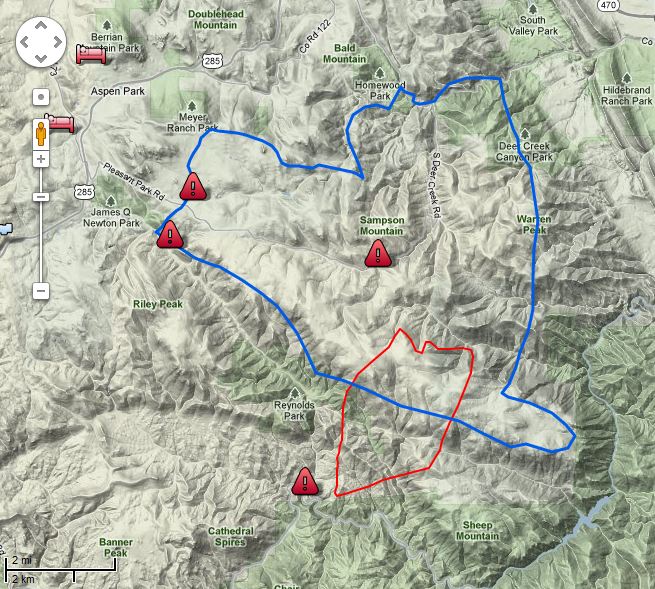
The map of the Lower North Fork fire below shows the perimeter (in red) as of 9:39 Wednesday night.
Map of Lower North Fork Fire. The blue line is the evacuation zone. The red line is the fire perimeter at 9:39 p.m. 3-28-2012. Map provided by Jefferson County Sheriff's Office
On Wednesday there were two large air tankers assigned, P2Vs, Tankers #44 and #45, but they were removed from the fire late in the afternoon and redeployed to the Apple fire south of Custer, South Dakota. (We were at the Apple fire yesterday.) There will be four National Guard Blackhawk helicopters assigned to the Lower North Fork fire today. Four helicopters dropped 49,000 gallons of water yesterday.
Residents seeking information about the status of their property within the fire evacuation zone may come to the Conifer High School, but the school is closed to the general public.
With the apparent cause of the fire being an escaped prescribed fire that was managed by the Colorado Forest Service, on Wednesday Deputy State Forester Joe Duda issued a statement that reads in part:
We want to express our deepest sympathy to those who have lost loved ones and those who have lost property, and we hope for the safety of crews as they continue to fight the fire.
On Wednesday the governor of Colorado suspended the use of prescribed burns by state agencies.
It is very early in the year, and early in the wildfire season, but already firefighters are competing for aerial and hand crew resources. There are not enough to go around, and they are not deployed where the fires are occurring. This is due in part to the diminishing budgets of the firefighting agencies, translated as fewer firefighters, and mismanagement of the federal air tanker fleet.
Other articles on Wildfire Today about the Lower North Fork fire:
Four Jefferson County Deputy Sheriff officers were trapped in the Lower North Fork wildfire on March 26, 2011, southwest of Denver, but they escaped eventually, unhurt. This is an audio recording of some of the radio traffic from that incident, courtesy of 9news who got it from a scanner feed.
Click on the green arrow to listen to the recording.
Lower North Fork Fire. Credit: Jefferson County Sheriff's Office
(We will update this throughout the day on March 28 as developments occur.)
UPDATE at 12:30 p.m. MT, March 28, 2012
The reported size of the fire has been changed from 4,500 to 3,790 acres. This latest size was calculated from an infrared mapping flight that occurred at 10:30 p.m. on March 27.
The Jefferson County Sheriff’s office has reduced the number of damaged structures from 28 to 27. One of the recorded addresses was not accurate.
We have an audio recording of radio traffic from an incident that occurred on March 26 on the fire when four Jefferson County Sheriff officers were entrapped in the fire. They escaped unhurt, but the audio is gripping.
The Denver Post has some fascinating video that was shot by residents driving out of the fire. They said they did not receive a reverse 911 phone call warning.
=================================================
UPDATE at 9:23 a.m. March 28, 2012
The Jefferson County Sheriff’s Office has updated their map of the fire with data from 8:20 p.m., March 27. The fire perimeter in red. The blue line is the evacuation area as of 2:00 p.m. on March 27. We expect they will give us an updated acreage later.
Map Lower North Fork Fire 8:30 p.m., 3-27-2012. Jefferson County Sheriff's Office
The Jefferson County Sheriff’s Office released some updated information at 8:30 a.m. on Wednesday:
Overnight the fire was relatively stable. Fire crews made progress through the night in protecting structures. Today’s strategy is to gain containment around the fire while continuing to protect structures.
Today’s fire behavior is expected to be similar to yesterday but with slightly higher winds. The winds could result in more robust fire activity. The fire will also most likely become more intense as the temperature rises throughout the day. The fire has continued to exhibit a tendency to start spot fires in a wide area.
[…]
The Jefferson County Sheriff’s Office will continue to man road blocks around the fire perimeter. At this time we are not allowing anyone back into the evacuated regions.
The Sheriff’s Office said the estimated size is still 4,500 acres and that 28 structures have been damaged.
The Lower North Fork fire that is southwest of Denver and seven miles southeast of Conifer, Colorado, was relatively quiet during the night. The last official acreage that was released by the Jefferson County Sheriff’s Office for the wildfire was 4,500, and they reported that 23 homes have been damaged. An elderly couple was found dead near their home and one resident within the burn area is missing.
The map of the fire shows the fire perimeter in red, as of 11:00 p.m. on March 26. The blue line is the evacuation area as of 2:00 p.m. on March 27. We will provide an updated map as more information is provided.
Map Lower North Fork Fire. Jefferson County Sheriff's Office
The firefighters’ strategy on Wednesday is to switch from point protection to constructing fireline to begin containment of the fire. They had hoped to do that on Tuesday, but the weather and fire behavior did not cooperate, pushing them back into a defensive and structure protection mode. Containment is still listed at zero percent, and 900 homes are still under a mandatory evacuation order. On Wednesday three air tankers (two P2Vs and one single engine air tanker) and four helicopters (including two National Guard Blackhawks) will be working on the fire. More aircraft are on order.
The Rocky Mountain Area Coordination Center reported Wednesday morning that Rich Harvey’s Type 1 Incident Management Team arrived and in-briefed at 8:00 p.m. on Tuesday and will assume command at end of the shift today. The RMACC says 3,790 acres have burned. This reduction in size is probably due to more accurate mapping as a result of the aircraft that Tuesday night used infrared equipment to determine the fire perimeter.
On Tuesday the Colorado State Forest Service released a statement saying a prescribed fire they ignited on Wednesday, March 21, escaped control on Monday, and investigations are underway to determine the cause of the Lower North Fork fire. The Denver Post earlier on Tuesday quoted Jacki Kelley, a Jefferson County Sheriff’s Office spokeswoman, as saying the fire originated from a controlled burn conducted by the Colorado Forest Service.
This first video is from a 6:00 a.m. newscast on March 27.
The video below is from March 26.
9news.com occasionally has live video reports about the fire.