Prescribed fire escapes on Eldorado National Forest

The fire has burned over 2,000 acres 15 miles southwest of Lake Tahoe in Northern California

Caples prescribed fire October 7, 2019
Caples “prescribed fire”. Photo by Forest Supervisor Laurence Crabtree, published October 7, 2019.

I was first aware of the Caples  prescribed fire on the Eldorado National Forest when three tweets were published by the forest’s Twitter account on the afternoon of Monday October 7 saying, “Ignitions continue on Caples Prescribed Fire. More smoke is expected”. Photos taken from an aircraft by Forest Supervisor Laurence Crabtree also were Tweeted.

At that time there had  been news and discussions for several days in the wildland fire community about very strong winds and Red Flag Warnings that were due to hit California Wednesday October 9. Smoke from the prescribed fire was easily detected by a satellite October 7. It was a large amount of smoke to be generated by what was supposed to have been some burning debris piles.

The project began October 1 and involved disposing of debris piles by burning. Additional ignitions occurred on October 5 and 7.

The information below came from the @EldoradoNF Twitter account.

Tuesday, October 8:  A tweet from the National Forest said, “The goal of today’s burn operation is continue active ignitions to reach the end of the ridge and tie into a dozer line that extends to the 10N30 road before the wind event that is predicted for this evening. No additional ignitions are planned this week.” And later that day, “Ignitions on the Caples Prescribed Fire have been completed and crews will patrol and monitor the area over the next few days during the wind. No additional ignitions are planned this week. ”

Wednesday October 9: “Today’s goal is to finish active ignitions to tie into the 10N30 road before the wind event now predicted for Wednesday night. Ignitions were intended to be done yesterday but due to unfavorable wind conditions during the day shift the operation is continuing today.”  And later that day, “Personnel on the Caples Prescribed Burn continue ignitions down the western perimeter of the fire towards forest road 10N30. A total of 1,080 acres have been treated, exceeding today’s target.” And later, “Ignitions are complete on the western end of the Caples Burn. Crews will patrol and monitor the area over the next few days during the wind event predicted to start this evening. Smoke will continue to be visible as the fire consumes unburned fuels within the fire perimeter.” And later, “The scheduled PG&E Power Outage has resulted in the closure of Eldorado National Forest offices except Camino ECC. Fire and essential personnel continue to work, however, forest offices are not open and phones are not operational until power is restored.”

Thursday, October 10: No additional information except for a Community Meeting scheduled in Pollock Pines that evening. One of the six items on the agenda was, “Brief updates on Caples Prescribed Fire and PG&E Power Outage”.

Friday October 11: “The Caples prescribed burn declared a wildland fire on today at 1:30 pm. Fire managers made the decision due to unfavorable weather conditions and the inability to meet previously established objectives. Inciweb is down. We will update when it comes back up.”


Today, October 11, personnel from the Eldorado National Forest report that the fire has burned 2,143 acres. It is 3 miles west of Kirkwood and 15 miles southwest of the south shore of Lake Tahoe. Approximately 152 personnel and a Type 3 Incident Management Team has been assigned.

Here is a report from the Northern California Geographic Coordination Center, Friday morning October 11:

Extreme fire behavior with wind driven runs, torching and spotting has been observed. A Red Flag Warning is in effect until 1000 this morning for the fire area. There is a threat to structures on remote ranches in the area. Private timberlands, major municipal watershed, historical sites and critical wildlife habitat are also threatened. Smoke impacts to the Sacramento Valley and Lake Tahoe areas are possible. Road, trail and area closures are in effect in the fire area.
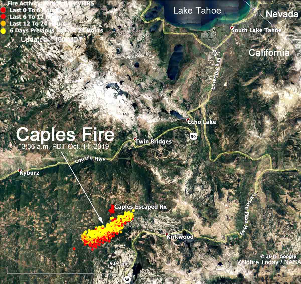
Caples Fire Map
Map showing heat on the Caples Fire detected by a satellite at 3:36 a.m. PDT October 11, 2019.

Caples Fire escaped prescribed fire information

Thanks and a tip of the hat go out to Fred. Typos or errors, report them HERE.

Prescribed fire escapes in Manti-La Sal National Forest

The Trail Mountain Fire has burned 2,637 acres in central Utah

Above: Map showing heat on the Trail Mountain Fire detected by a satellite at 2:18 a.m. MDT June 12, 2018.

A prescribed fire ignited in the Manti-La Sal National Forest in central Utah has burned 2,637 acres eight miles northwest of Huntington.

U.S. Forest Service personnel began the project on Tuesday June 5 after conducting a test burn the day before. When they had to suppress a seven-acre spot fire on Wednesday they stopped igniting the prescribed fire, but that evening the fire ran to the top of East Mountain. It is now known as the Trail Mountain Fire.

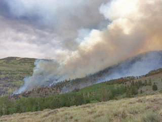
Trail Mountain Fire
Trail Mountain Fire, posted to InciWeb around June 8, 2018.

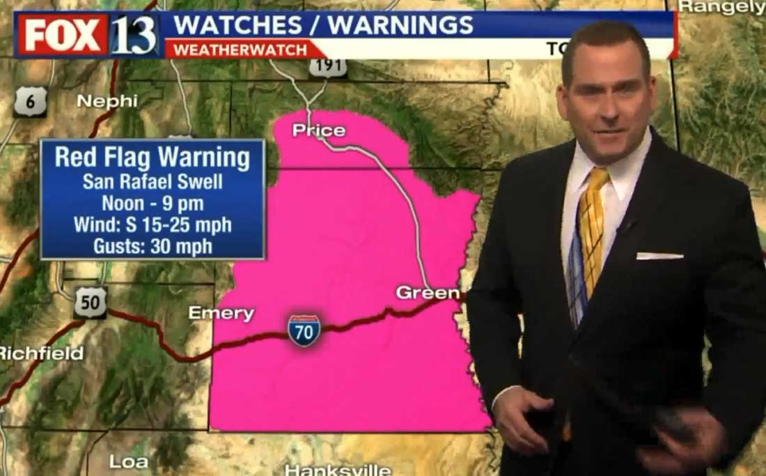
On Thursday a Red Flag Warning for strong wind was in effect and the fire continued to grow until it stopped temporarily at a high voltage power line. At that time a Fire Weather Watch predicted elevated fire danger on Saturday and Sunday, June 9-10.

red flag warning trail mountain escaped prescribed fire
Red Flag Warning in central Utah June 7, 2018. Screenshot from Salt Lake City Fox 13.

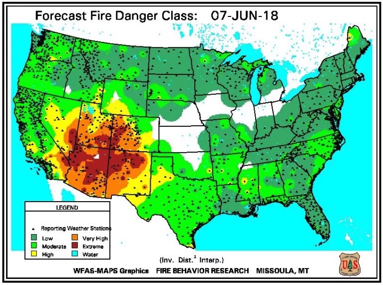
The fire was very active on Sunday, lofting burning embers that started spot fires a mile ahead. At least one cabin and some outbuildings have burned.

fire danger June 7, 2018

Below is information released by fire officials on Monday June 11:

The Trail Mountain Fire moved into Meetinghouse Canyon Sunday after it was hit with wind gusts of up to 55 miles per hour. Winds grounded all air support and caused the fire to run north and east. Currently at 2,637 acres, and 10% containment, the fire has created heavy smoke that has been visible from local communities in Emery, Carbon and Sanpete counties.
The fire is burning in mixed conifer, with large amounts of dead and down timber. It is spotting up to a mile, leaving islands of green aspen and sage untouched. A cabin was burned in the Whetstone Creek area and other outbuildings in that area are threatened. A high voltage line is in the path of the fire, but has not sustained significant damage. The powerline remains off.

There are 259 personnel assigned to the fire, five helicopters and 11 engines. There is Temporary Flight Restriction over the fire. No drones are allowed on the fire.

Tim Roide’s Type 2 Incident Management Team will be assuming command of the fire, taking over from a Type 3 Team.

The Emery County Progress has an excellent article about the fire written by Patsy Stoddard. It is one of the best I have seen about a wildfire — very thorough and detailed.

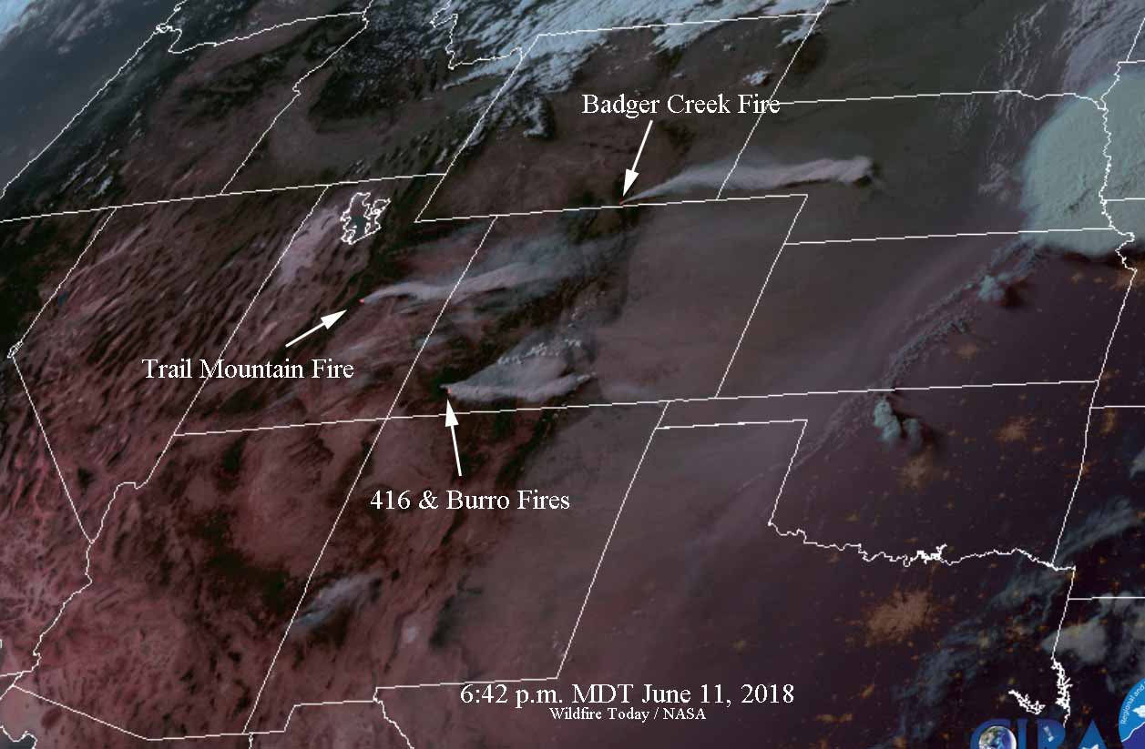
Smoke blowing into Colorado from the fire is visible from space.

trail mountain fire badger creek 416
Satellite photo at 6:42 p.m. MDT June 11, 2018, showing the Trail Mountain Fire, Badger Creek Fire, and the 416 Fire.

Repercussions of a government prescribed fire that escapes and burns private property

In 2010 a prescribed fire on the Helena National Forest escaped and burned approximately 450 acres of private property.

Davis Fire, Aug. 26, 2010
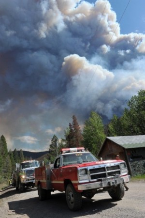
Davis 5 Fire, Aug. 26, 2010. Photo: markholyoak

On August 26 and 27, 2010 the Davis 5 prescribed fire on the Helena National Forest in Montana escaped control 28 miles northwest of Helena. It happened on a windy day during Fire Weather Watch conditions when the temperature in Helena set a record for the highest ever recorded on that date .

(Articles on Wildfire Today tagged “Davis 5 prescribed fire”)

The project that was expected to treat 100 acres eventually burned about 1,600 acres of U.S. Forest Service land and approximately 450 acres of private property.

Today the Helena Independent Record and the Missoulian published an article written by Tim Kuglin that retells the story of the Davis 5 Fire. Mr. Kuglin concentrated on the effects on the private landowners and their battles, largely unsuccessful, to obtain reparations from the federal government.

The post-fire report commissioned by the U.S. Forest Service, as is the custom with federal land management reports about fires that have bad outcomes, did not outline many significant issues or bad decisions that led to the escape.

Davis fire
Firemen line the Stemple Pass Road August 26, 2010, on the Davis Fire. Dylan Brown photo.

Most of Kent Taylor’s 146 acres burned in the fire. After being rebuffed by the USFS he went to court to seek payment for damages. Senior U.S. District Judge Charles Lovell decided on March 22, 2015 that the U.S. is immune from the suit, writing in his decision:

The Court concludes that Plaintiff has failed to demonstrate that the Forest Service was negligent either in conducting the Davis 5 Unit prescribed burn or in fighting the escaped fire once it occurred or that the Forest Service violated any mandatory policy or prescription. In addition, and more significantly, strict liability does not apply and the discretionary function exception applies to bar Plaintiff’s tort claims.

The court decision, the official USFS report, and the recent newspaper article did not seriously consider two issues that we mentioned in 2010:

1. The first was the failure to take notice of the spot weather forecast that was issued at 10:43 a.m. Wednesday on the day of the burn, just before the firefighters ignited the test burn. That forecast predicted stronger winds than in the forecast that was issued the previous day which was for “winds upslope 3 to 6 mph, ridge top winds southwest 5 to 10 mph with gusts to 15 mph”. Here is what Wednesday morning’s forecast predicted for the day of ignition (the all-caps are from the weather forecast):

WIND (20 FT)……..SOUTHWEST WINDS 10 TO 15 MPH WITH AFTERNOON GUSTS 20 TO 25 MPH.
RIDGE TOP WIND……WEST AT 15 TO 20 MPH.

The report says:

The prescribed fire personnel stated they did not note any differences between the two forecasts.

That forecast also stated that on the following day, Thursday, the winds in the afternoon would be 30 to 35 mph.  The maximum wind speed allowed in the prescription for the project was 15 mph, which, from my experience, is quite high for a prescribed fire.

2. The second issue is the fact that they knew on Tuesday, the day before the burn began on Wednesday, that near record heat and a Fire Weather Watch with gusty southwest winds was forecast for Thursday. This Watch was upgraded to a Red Flag Warning on Wednesday afternoon after ignition had begun. Even in a best case scenario, if there had been no spot fires or other control problems on Wednesday, the 30 to 35 mph winds predicted for the day after ignition should have alerted experienced fire management personnel that the winds across the 100-acre prescribed fire could have caused embers to be blown across the lines, resulting in the fire escaping. Control would have been difficult in 30 to 35 mph winds.

Two reports released on the same day about the escaped prescribed fire near Carson City, NV

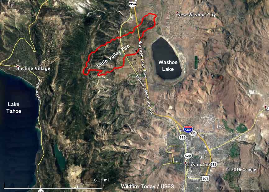
Above: Map of the Little Valley Fire at 9:23 p.m. PDT October 14, 2016.

On February 15 two reports were released about the prescribed fire that escaped, burned 2,291 acres, and destroyed 23 homes northwest of Carson City, Nevada on October 14, 2016. The first report about what became the Little Valley Fire included the results of a months-long independent investigation by the Reno Gazette-Journal (RGJ). The other, released a few hours later, was the product of the official investigation requested by the Nevada Division of Forestry (NDF), the agency responsible for conducting the prescribed fire.

Hours before the fire escaped, all eleven firefighters that had been mopping up the prescribed fire left the project and returned to their stations between 1:30 p.m. and 4:45 p.m. on October 13, 2016. During that day there were a number of smokes that received the attention of the firefighters. During the last two hours before the seven-person helitack crew departed they noticed the wind increasing — trees were blowing down and branches were falling.

The RGJ reported on the reason the firefighters were ordered to leave the burn site.

Gene Phillips, NDF forest health specialist and burn boss for the Little Valley Burn, made the decision to pull crews from the burn site after discussing the high wind forecasts for the evening with a burn boss trainee, according to the review.

The decision not to staff the site on the evening of Oct. 13 was made, according to NDF, “based on the limited amount of heat near the control lines, success of the current mop-up effort, and the risk to firefighters working in timber during high winds.”

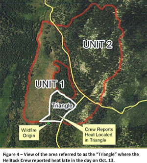
escaped fire map
From the NIMO report.

At 5:38 p.m. the Little Valley weather station recorded sustained winds out of the west at 15 mph with a maximum gust of 39 mph. By 12:38 a.m. on October 14, about the time the fire escaped, the wind was at 19 mph with gusts up to 87 mph. The relative humidity was 32 percent.

A Red Flag Warning for gusty winds and low humidity was in effect from the morning of October 11 through 5 p.m. on October 14. Strong winds persisted until mid-day on October 17.

The NDF’s report was written by the U.S. Forest Service’s Phoenix National Incident Management Organization (NIMO), a team that usually manages fires and other incidents that are often of longer duration than a typical wildfire. The team was supplemented with a Fire Behavior Analyst, a GIS/Fire Behavior Analyst, a Public Information Officer, a Fire Investigator, and others for a total of 10 personnel that were listed in the report.

The NIMO team concluded that the fire escaped when embers from a burning stump hole were blown 34 feet and crossed the fireline at a corner, or “dog leg” in the fire perimeter.

According to the RGJ there was confusion in initially responding to the fire after it escaped at around 12:38 a.m. on October 14:

Response to the fire was delayed, affecting how fast it could be contained: A call at 1:23 a.m. about smoke at the burn site was later dismissed as “unfounded,” causing a TMFPD [Truckee Meadows Fire Protection District] fire engine to return to the station three minutes after it left. After a second call about smoke at the burn site, it took TMFPD more than an hour to get to the site after crews were dispatched, according to 911 transcripts.

Report released on escaped prescribed fire in northern Minnesota

The fire burned 1,008 acres on the Superior National Forest.

Above: Photo of the Foss Lake Fire, from the report.

A report has been released for a prescribed fire that escaped on May 19, 2016 and burned an unexpected 1,008 acres 10 miles west of Ely, Minnesota. The U.S. Forest Service had intended to burn 78 acres, but extremely dry conditions and winds pushed a spot fire beyond the capabilities of the Hotshot crew and the engine initially assigned to the project. The fire danger index for the Energy Release Component at the time was setting 20-year maximums.

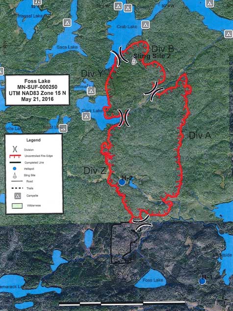
Foss Lake Fire map
The perimeter of the planned prescribed fire is outlined in black, in the gray shaded area. The escaped area is in red.

You can read the entire report here, but below are highlights:

  • Some of the firefighting resources listed as contingency forces in the burn plan were national resources not committed to the prescribed fire and were assigned to other fires when needed on the escape.
  • According to a spot weather forecast the conditions that morning were at the hot end of the prescription and in the afternoon may go out of prescription. There was a discussion about possibly having to pause ignition for a period of time in the afternoon.
  • The test fire began at 11:40 a.m. Soon thereafter the primary ignition began.
  • Within 40 minutes of starting the test fire spot fires began to occur near the fireline, but they were suppressed. At 12:50 p.m. a larger spot fire, 1/4 to 1/2 acre, was discovered 100 yards north of the main burn by firefighters patrolling in a canoe. The firing boss ordered the igniters to slow down.
  • When the larger spot fire occurred, firefighters installed a hose lay from a river to the site but were not able to start a pump to supply the water. A replacement pump that had been working in another area that day was brought in but it also refused to run.
  • At 12:53 p.m. a water-scooping Beaver air tanker that could carry up to 130 gallons of water was requested by the Zone Fire Management Officer (ZFMO) who was at the site, and 11 minutes later he asked for a Type 3 helicopter.
  • At 1:41 p.m. personnel on the fire declined offers or suggestions for “heavy aircraft” and also a Type 1 helicopter that had become available.
  • Between 1:59 p.m. and 2:26 p.m. personnel on the fire requested the Type 1 helicopter, air attack, two 20-person crews, a CL-415 scooping air tanker, and two large air tankers.
  • At 2:07 p.m. the Burn Boss declared the escaped fire to be a wildfire and began shutting down the original prescribed fire.
  • At approximately 1700 a Type 2 Incident Management Team was ordered for the escaped wildfire, which was then several hundred acres in size.
  • At 10:09 p.m. all personnel on the prescribed and escaped fires were released and returned to Ely.

Our original report on the escaped prescribed fire last May.

Little Valley Fire burns structures northwest of Carson City, NV

In the hours before the fire was reported, wind gusting at 87 mph was recorded at a nearby weather station.

(UPDATED at 11:35 p.m. PDT October 14, 2016)

At 9:30 p.m. Washoe County updated the number of structures burned — 22 homes and 17 outbuildings. The fire has blackened 3,455 acres.

Map Little Valley Fire
Map of the Little Valley Fire at 9:23 p.m. PDT October 14, 2016.

****

(UPDATED at 3:24 p.m. PDT October 14, 2016)

Washoe County reported at 2:45 p.m. Friday about the Little Valley Fire:

Everyone who lives on the east side of Washoe Lake or the east side of I-580 can return home.

Evacuations for residents of the Galena, Montreaux, Joy Lake Rorad, and St. James neighborhoods can return home but need to be prepared to evacuate throughout the weekend if need be.

The west side of Washoe Lake from Bowers exit to the bottom of Franktown Rd. remains evacuated. Several local hotels are offering discounted room rates for those displaced by Friday’s fires.

A weather station near the fire recorded 0.10 of rain after 11 a.m. today. The relative humidity has increased to 83 percent but the wind is still strong, 14 mph gusting to 34 mph. Radar showed light rain in the area at 3:24 p.m. on Friday.

@TMFPD is the Twitter account for the Truckee Meadows Fire Protection District.

****

(Originally published at 1:16 p.m. PDT October 14, 2016)

Dozens of structures have burned in the Little Valley Fire 6 miles northwest of Carson City, Nevada and 17 miles south of Reno. It was reported at 2 a.m. PDT on Friday, Oct, 16, 2016. At 12:15 p.m. Washoe County reported that firefighters are estimating 2,000 acres, 18 homes, seven outbuildings, and seven barns have burned in the fire west of Washoe Lake.

Authorities have not released a cause for the fire but the Reno Gazette-Journal raised the possibility that it might have been associated with a prescribed fire:

As part of the investigation on the cause of the fire, the forestry division will look into any potential links from a prescribed burn that was held prior to the fire, said Jenny Ramella, Nevada Forestry Division spokeswoman. Ramella stressed that the cause of the fire has yet to be determined.

We don’t yet have a good map showing the exact location of the wildfire, but the Nevada Division of Forestry covered on their Facebook page the progress of the “Little Valley Burn”, a prescribed fire, that was ignited between October 4 and 7. On October 12 the NDF reported they had completed 208 acres. The location appears to have been west of where the wildfire is burning now.

Continue reading “Little Valley Fire burns structures northwest of Carson City, NV”