Ferguson Fire claims more acreage on west, south, and east sides

The fire near Yosemite National Park grew by over 5,000 acres during the last two days

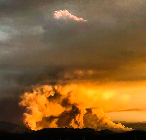
(Above: Ferguson Fire photo uploaded to InciWeb around July 18, 2018)

(Originally published at 3:24 p.m. MDT July 20, 2018)

The Ferguson Fire that has been burning since July 13 has become almost predictable over the last three or four days, adding a few thousand acres each day. Since we last wrote about this fire two days ago west of Yosemite National Park in California it has added about 5,500 acres, again on the west, south, and east sides bringing the total up to 22,892 acres. So far firefighters have been mostly successful in keeping the north side of the fire from crossing Highway 140, one of the several routes into the Park. The highway has been closed from El Portal Road to 1.5 miles West of Midpines for several days.

CLICK HERE to see all of the articles on Wildfire Today about the Ferguson Fire, including the most recent.

Map perimeter Ferguson Fire
Map showing the Ferguson Fire, mapped at 10:15 p.m. PDT July 19, 2018. The red shaded areas represent intense heat at that time, while the yellow line was the perimeter two days before. Click to enlarge.

About half a dozen areas are under mandatory evacuation orders, primarily on the north and west sides of the blaze. Other areas have been warned that they may have to evacuate on short notice.

On Thursday firefighters worked on the primary containment line on the west side of the fire along Henness Ridge which should be complete by the end of the day on Friday. Firefighters working on indirect lines (built away from the fire’s active edge) around the community of Jerseydale also made good progress Thursday.

As of Friday morning no structures have been damaged or destroyed.

Yosemite National Park remains open, but often the smoke is very dense. For information about the park, go to: nps.gov/yose or call 209-372-0200.

Earlier today we posted a map that shows the distribution of wildfire smoke in the United States.

Ferguson Fire spreads south, adds 5,000 acres

The fire has burned 17,319 acres northeast of Mariposa, California

Above: Map showing the perimeter of the Ferguson Fire at 11:34 p.m. PDT July 17. The red shaded areas represent intense heat at that time. The yellow line was the perimeter two days before.

Again Tuesday the Ferguson Fire spread in all directions. On the north side firefighters are attempting to tie it in with one of the routes that leads into Yosemite National Park, Highway 140. The highway has been closed west of El Portal since the fire started on July 13 and there’s no indication when it will reopen. Other routes into the park are open, but Yosemite Valley has severely degraded visibility due to heavy smoke from the fire.

Most of the growth Tuesday and Tuesday night was on the southeast and southwest sides. The high pressure that has been dominating the area is causing an inversion that has been preventing the smoke from blowing out of the area, holding it close to the ground. This makes it difficult or impossible to use fixed wing air tankers until the inversion breaks in the late afternoon when the inversion lifts.

CLICK HERE to see all of the articles on Wildfire Today about the Ferguson Fire, including the most recent.

On Tuesday the fire backed down Ferguson Ridge and became well established in the Sweetwater Creek drainage and behind Cedar Lodge. Crews worked Tuesday night to secure line around Cedar Lodge and Indian Flat. The power line has been repaired, and electrical service has been restored to the area. Work on Tuesday involved improving containment lines, as well as protecting the communities of Jerseydale, Mariposa Pines. and Yosemite West.

Judging by the number of resources assigned, the Ferguson Fire is becoming a very large incident. There are a total 1,850 personnel, including 158 engines, 5 water tenders, 5 helicopters, 44 hand crews, and 16 dozers. A mapping flight Tuesday night determined it has burned 17,319 acres.

The weather on Wednesday will again be hot and dry, and the inversion will most likely keep air tankers grounded until late afternoon.

Ferguson Fire grows to over 12,000 acres

The fire has caused evacuations west of Yosemite National Park in California

(Originally published at 8:07 a.m. PDT July 17, 2018)

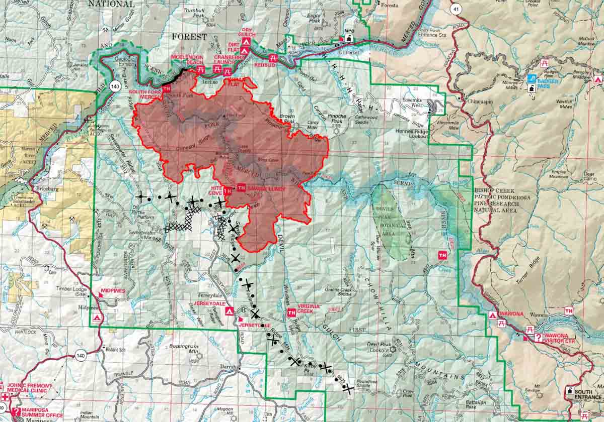
map Ferguson Fire
Map produced by the Incident Management Team, July 17, 2018. The line with the dots and plus signs represents a proposed dozer line. Click to enlarge.

For days the Ferguson Fire has been marching across the remote, steep terrain west of Yosemite National Park. On Monday it grew on all sides to some extent, with most of the additional blackened acres being added on the south and east sides.

Areas that are under mandatory evacuation orders include Incline Road from Clearing House to the last BLM campground; Jerseydale/Mariposa Pines; Cedar Lodge/ Indian Flat Campground, Savage’s Trading Post and Sweetwater Ridge.

CLICK HERE to see all of the articles on Wildfire Today about the Ferguson Fire, including the most recent.

Many areas are under an advisory or potential evacuation order should conditions change. A few examples are Yosemite West, National Park Service El Portal Complex, and Old El Portal. The Mariposa County Sheriff’s office has more current details about evacuation orders.

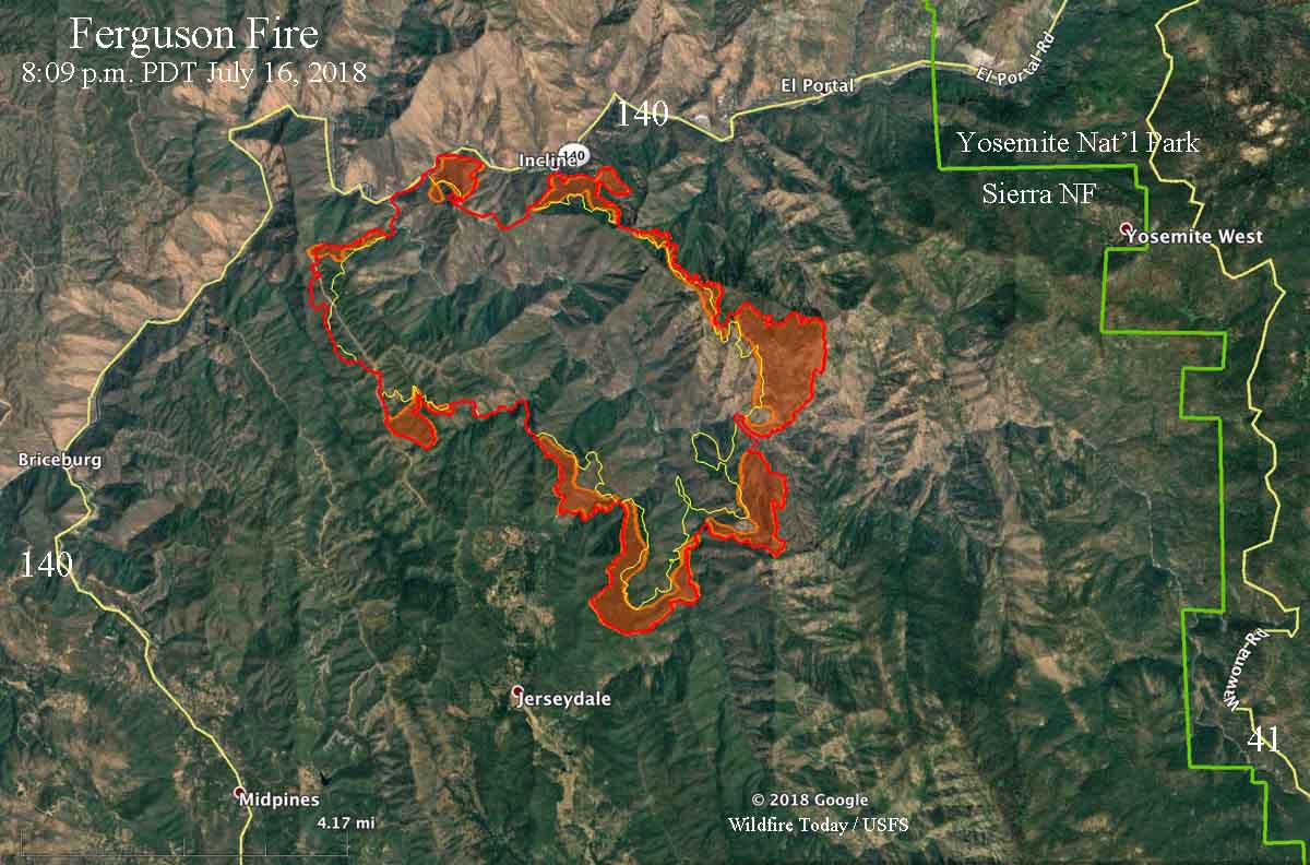
map Ferguson Fire
Map with red shaded areas indicating areas of intense heat at 9:08 p.m. PDT July 16, 2018.

Monday morning the incident management team announced that overnight mapping flights determined that 12,525 acres have burned in the Ferguson Fire.

Road closures:

  • Highway 140 from Abbie Rd in El Portal to 14 miles north of Mariposa;
  • Incline Road;
  • River Road from Briceburg to the gate at Railroad Flat;
  • Hites Cove / Jerseydale Road.

Approximately 1,486 personnel are assigned to the fire, including 118 engines, 5 water tenders, 4 helicopters, 39 hand crews, and 16 dozers. Air tankers are assigned as needed and as smoke and visibility allow. We have seen up to eight being used at the same time, ranging from the 1,200-gallon S2T’s to the 11,600-gallon DC-10’s.

Ferguson Fire forces evacuations in Jerseydale area

The fire has burned over 9,000 acres west of Yosemite National Park in California

(UPDATED at 7:50 a.m. PDT July 16, 2018)

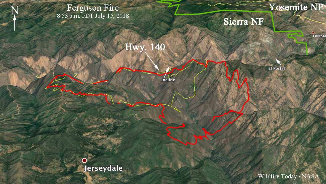
3-D map Ferguson Fire
3-D map of the Ferguson Fire at 8:53 p.m. PDT July 15, 2018. Click to enlarge.

After 3 p.m. Sunday the intensity of the Ferguson Fire increased dramatically as it spread 1.5 to 2 miles to the south and southeast, coming closer to the structures in the Jerseydale area.

Mandatory evacuation orders are still in effect. Sunday morning a fire advisement was issued for the Yosemite West area, which is on Wawona Road southeast of El Portal. It is an advisement of a potential Evacuation Order should conditions change.

CLICK HERE to see all of the articles on Wildfire Today about the Ferguson Fire, including the most recent.

Based on an 8:53 p.m. mapping flight Sunday night the Incident Management Team reported that the fire at that time had burned 9,266 acres.

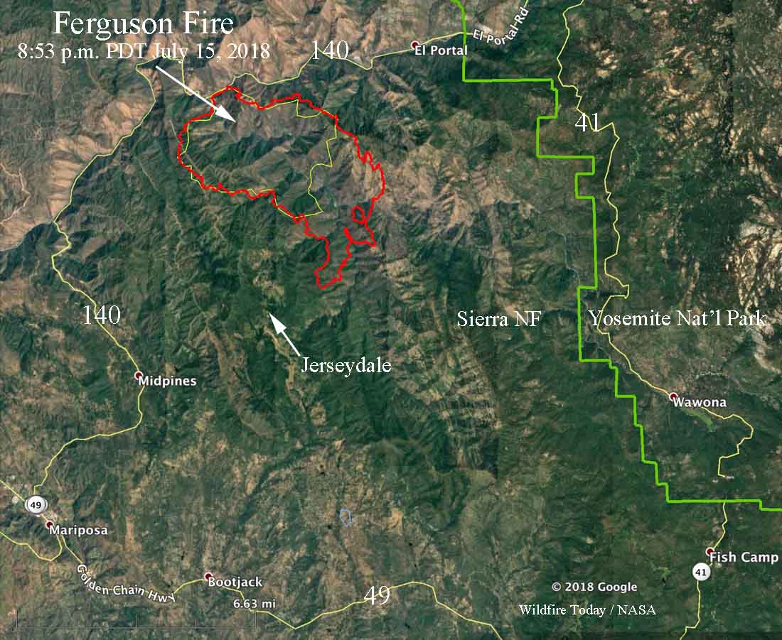
map ferguson fire
Map of the Ferguson Fire at 8:53 p.m. PDT July 15, 2018. The yellow line was the approximate perimeter at 2 p.m. July 15. Click to enlarge.

The weather at the Ferguson Fire is expected to remain hot and dry for the next seven days, with isolated thunderstorms possible.

The 20-second video below is a time-lapse of still images of the fire captured between 1:30 p.m. and 4 p.m. July 15. Toward the end you will see a smoke column break through the inversion as the fire intensity increases. Sierra Fire Watch posted it, saying it was shot from a point near Mt. Raymond.


(UPDATED at 7:41 p.m. PDT July 15, 2018)

Ferguson Fire
Ferguson Fire. Photo uploaded to InciWeb Sunday afternoon.

Continue reading “Ferguson Fire forces evacuations in Jerseydale area”

Firefighter fatality on the Ferguson Fire west of Yosemite National Park in California

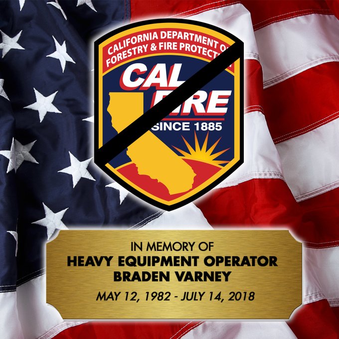
We regret to have to report that a firefighter died this morning, July 14, on the Ferguson Fire west of Yosemite National Park. CAL FIRE announced this afternoon that Heavy Fire Equipment Operator Braden Varney was tragically killed while battling the fire. Mr Varney leaves behind a wife and two small children.

One of the firefighters on the fire reported this morning that he thought there was a dozer rollover, and just in case, he wanted to get medical help started to the scene. It turned out that the dozer had rolled several times and ended up in a location that was very difficult to access by foot or see from an aircraft.

(To see all of the articles on Wildfire Today about the Ferguson Fire, including the most recent, click here.)

Just after 1 p.m. local time CAL FIRE made the official announcement about the fatality.

We send out our sincere condolences to Mr. Varney’s family, coworkers, and friends.Varney fatality

Ferguson Fire burning west of Yosemite National Park

Above: map showing heat on the Ferguson Fire detected by a satellite at 3 a.m. PDT July 14, 2018.

(UPDATED at 3:15 p.m. PDT July 14, 2018)

For a while late Saturday morning, smoke and impaired visibility grounded all air tankers on the Ferguson Fire, but by early afternoon the smoke had cleared enough to bring them back to drop retardant.

(To see all of the articles on Wildfire Today about the Ferguson Fire, including the most recent, click here.)

Now we are hearing that the fire has spotted across the South Fork of the Merced River on the west side of the fire. There is an effort to have the air tankers pretreat a ridge in an attempt to slow down the fire in that area.


(UPDATED at 2:02 p.m. PDT July 14, 2018)

We regret to have to report that a firefighter died this morning on the Ferguson Fire west of Yosemite National Park. CAL FIRE announced this afternoon that Heavy Fire Equipment Operator Braden Varney was tragically killed while battling the fire. Mr Varney leaves behind a wife and two small children.

One of the firefighters on the fire reported this morning that he thought there was a dozer rollover, and just in case, he wanted to get medical help started to the scene. It turned out that the dozer had rolled several times and ended up in a location that was very difficult to access by foot or see from an aircraft.

Just after 1 p.m. local time CAL FIRE made the official announcement about the fatality.

We send out our sincere condolences to Mr. Varney’s family, coworkers, and friends.


(UPDATED at 9:26 a.m. PDT July 14, 2018)

At 9:26 a.m. PDT Air Attack said the Ferguson Fire was holding at about 150 acres. The terrain, smoke, and power lines are challenges for the air tankers working the fire.

aircraft ferguson fire
At 9 a.m. PDT flight tracking showed two S2T air tankers and an Air Attack aircraft over the Ferguson Fire. The green line was the approximate track of the Air Attack ship.

(Originally published at 7:44 a.m. PDT July 14, 2018)

Highway 140, one of the three highways that lead into Yosemite Valley in California, is closed due to a new wildfire. The Ferguson Fire was reported at 10:35 p.m. Friday and at last report had burned about 75 acres. The fire is just off Highway 140 near Hite Cove and has high potential to grow. Since firefighters were working under electrical lines the power in the area has been shut off, which may affect Yosemite National Park. The area around Savages Trading Post has been evacuated.

The fire is spreading in steep terrain in the Sierra National Forest 7 miles west of El Portal. The incident commander has requested four fixed wing air tankers, of any type, to attack the fire early Saturday morning if possible. They also requested dozers, helicopters, water tenders, and hand crews.