A ball and chain is not always a bad thing

At least not when it is used to reduce a fire hazard

ball and chain vegetation management fire hazard

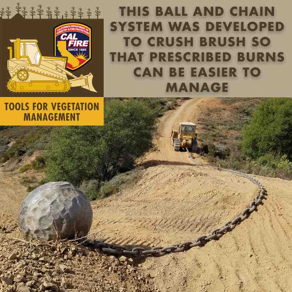
This image posted on Twitter by the California Department of Forestry and Fire Protection, CAL FIRE, reminded me of when I was involved with a ball and chain operation one winter on the Sitton Peak project on the Cleveland National Forest in Southern California in the early 1970s.

The objective is to rip out or crush brush in order to reduce the wildfire hazard. It can be used to create a fuel break in lighter brush, or knock down heavier brush to make it easier and safer to conduct a prescribed fire.

When I was the contracting officer’s representative (COR) on the project a large dozer pulled about 100 to 200 feet of anchor chain that weighed 40 to 80 pounds per link. At the far end of the chain was a Navy surplus steel ball, a float, about five or six feet in diameter, that had been used with an anti-submarine net. The float was designed to support a net made of steel cable that was stretched across the mouth of a harbour or a strait for protection against submarines. A seven-mile long net was in place across the entrance to San Francisco Bay on December 7, 1941.
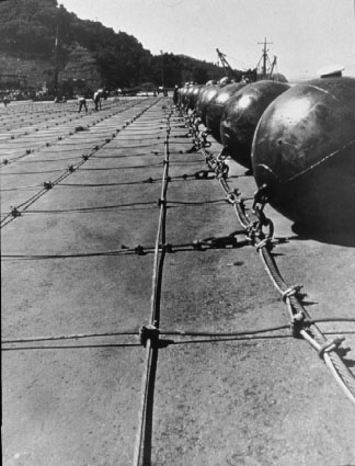
Anti-submarine net floats
Anti-submarine net and floats. US Navy photo
anti-submarine net
U.S. Navy

When the system was used on the Sitton Peak project we found that the ball needed to be heavier, so we filled it with water. That didn’t last long because the ball led a hard life, constantly being dragged across the ground and over rocks. The water leaked out through gouges in the steel. We later experimented with other materials inside the ball, including gravel, that were retained for a longer period of time.

Landscape architects liked the appearance of a chained fuel break better than those constructed by a dozer blade because it left some vegetation and a feathered edge — a more natural shape with fewer straight lines. As the dozer pulled the assembly, the chain encountered variable resistance and would temporarily get hung up on a rock or a heavy brush patch. If the dozer was driving along a ridge top, this would cause the ball to traverse up and down the slope, leaving a zig-zag or irregular edge.

When used on flat ground, the ball is positioned and then the dozer drives in circles around it.

With the brush crushed, close to the ground, and later dried out, it can then be treated with prescribed fire that burns less intensely than standing live brush in the summer.

A ball and chain is not exactly a light-hand-on-the-land system. There is serious soil and vegetation disturbance, so before considering the method, any sensitive plants, animals, and artifacts need to be carefully evaluated.

Back in 2009 I wrote about a misadventure that involved the dozer we used on the Sitton Peak project. It became seriously stuck in mud while “walking” back from the project on a dirt road. Four trucks that came to rescue the dozer also got stuck in the same area. It was one of those incidents where rescuers became victims. The article has photos I took of the FUBAR incident.

BLM to develop EISs for fuel breaks and fuel reduction

The programmatic Environmental Impact Statements would streamline approvals for projects

Above: A fuel break created along a road by mowing. BLM photo.

(Originally published at 9:55 a.m. MDT December 30, 2017)

In May the U.S. Geological Survey began an effort to study fuel breaks in the Great Basin to evaluate their effectiveness as well as the ecological costs and benefits. On December 22 the Bureau of Land Management announced the agency is proposing to develop two Environmental Impact Statements (EIS) for BLM lands in the states of Idaho, Oregon, Nevada, California, Utah, and Washington. One will cover the construction of fuel breaks while the other is for fuels reduction and rangeland restoration.

The process is expected to result in two programmatic EIS documents that would cover projects region-wide to gain efficiencies in subsequent National Environmental Policy Act (NEPA) analyses. The blanket approval will mean that individual landscape-scale fuel breaks and fuel reduction proposals will only need minor additional environmental reviews to proceed.

Fuel breaks are intended to interrupt the continuity of vegetation making it easier to control or stop the spread of wildfires. There is no guarantee of success since wind-blown burning embers can be lofted hundreds or thousands of feet ahead of a flaming front, crossing the breaks.

fuel break herbicide aerial application
An aircraft sprays herbicide on a BLM fuelbreak. BLM image.

Landscape-scale fuel reduction would slow the spread and reduce the intensity and resistance to control of a wildfire making it easier for firefighters to keep a small fire from becoming a megafire. Another goal of the vegetation modification is to restore the rangelands habitat in order to provide multiple use opportunities for user groups and habitat for plants and animals. The projects are designed to reduce the threat of habitat loss from fires and restore rangeland’s productivity while “supporting the western lifestyle”, the BLM said in a statement.

The public has until February 20, 2018 to submit comments related to the programmatic EISs by any of the following methods:

  • Website: https://go.usa.gov/xnQcG
  • Email: GRSG_PEIS@blm.gov.
  • Fax: 208–373–3805.
  • Mail: Jonathan Beck, 1387 S. Vinnell Way, Boise, ID 83709
BLM fuel break
BLM fuel break. BLM photo.

BLM: fuel breaks stopped spread of Centennial Fire

The BLM fuel breaks are initially created by using herbicides

Above: screenshot from the BLM video showing a fuel break.

(Originally published at 10 a.m. MST December 2, 2017)

The Bureau of Land Management produced this video that explains their philosophy of creating fuel breaks in Idaho by using herbicides followed by planting fire resistant vegetation such as “Stabilizer” Siberian wheatgrass. The 2017 Centennial Fire west of Twin Falls would have grown much larger, they claim, had it not stopped at a fuel break 275 feet wide.

fuel break herbicide aerial application
An aircraft sprays herbicide on a BLM fuelbreak. Screenshot from the BLM video.

USGS to study fuel break effects on wildfires, sage-grouse

Above: Roads through areas prone to wildfire act as fuel breaks, disrupting the fuel continuity, potentially reducing the rate of fire spread. The areas on either side of the road have also been mowed to reduce vegetation height. Photo courtesy of BLM.

The U.S. Geological Survey is gearing up for a project across the Great Basin studying how effective fuel breaks are, simultaneously evaluating their ecological costs and benefits.

Fuel breaks like sandy roads or other barriers are intended to reduce fire size and frequency by slowing or altogether halting fire’s spread to the other side of the break. Still, questions remain about whether fuel breaks protect sagebrush and sage-grouse, the USGS said in a comments discussing the new research. 

“We want to determine the extent to which fuel breaks can help protect existing habitat from wildland fires, paying particular attention to how such breaks affect sagebrush habitat, sage-grouse, and other sagebrush-dependent species,” the USGS said in a statement. 

Additional information about the research can be found on the USGS site. 

Alaska: Funny River Fire becomes megafire

 (UPDATE at noon, MDT, May 29, 2014)

The Funny River Fire at Soldotna, Alaska has burned 192,831 acres and the Incident Management Team is calling it 46 percent contained.

Below is a report from the Team:

Cooler, damper weather moderated fire activity on Tuesday which allowed firefighters to switch from defense to offence for the first time since the Funny River Fire started nine days ago. Crews reinforced the containment lines on the west side of the fire in the Kasilof and Sterling Highway areas, and in the Funny River Road area. Progress was made with containment line on the north side of Torpedo Lake on the north side of the Kenai River. Overall fire containment is now 30 percent, with 713 firefighters working to keep the fire away from populated areas.

The evacuation order along the Funny River Road was cancelled yesterday and most residents returned to their homes. All remaining evacuation advisories have been lifted. The Lower Skilak Lake Campground remains closed until further notice.

Five structures were confirmed as lost to the fire. The owners were notified by the Kenai Peninsula Borough. These structures include one outbuilding (the main structure was saved), and four recreation cabins with limited access.

On Tuesday firefighters rescued five abandoned wolf pups on the fire. Check out the story and the photos HERE.

We posted some very interesting satellite photos of the fire in another article.

****

(UPDATE at 6:28 p.m. MDT, May 27, 2014) An update from the Funny River Fire incident Managment team at about 6 p.m. MDT:

Firefighters made excellent progress yesterday extending containment lines on the west side of the fire in the Kasilof and Sterling Highway areas. Crews also completed burnout operations along the northern perimeter (south of Funny River road) late in the day helping to secure areas that had burned over containment lines on Sunday. The fire grew to over 182,000 acres as winds continued to push the fire perimeter northeast towards the Skilak Lake Road and further east into the wildlife refuge area. Overall fire containment is now 30 percent.


The evacuation order along the Funny River road has been cancelled. Residents are allowed to return to their homes. This area remains under an evacuation advisory. The evacuation advisory along the Sterling Highway was also lifted. The Kenai Keys area remains under an evacuation advisory. The Lower Skilak Lake Campground remains closed until further notice.

**** (UPDATE at 10:35 a.m. MDT, May 27, 2014)

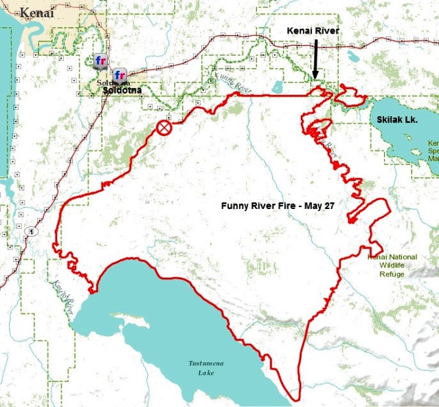
Funny River Fire, May 27, 2014
Funny River Fire, May 27, 2014 (ESRI). The black annotations were added by Wildfire Today.

On Monday the Type 2 Incident Management Team for the Funny River Fire at Soldotna, Alaska mentioned that the fire had crossed the Kenai River near Torpedo Lake. The map, above, that we found on the Team’s Facebook page (it is not on their InciWeb page) shows that the fire has become established east of the river. It is no longer just a spot fire. Monday night the Team said the fire had burned 176,069 acres and 670 personnel were assigned. There have been no serious injuries. It is becoming difficult to find current, official information about the fire. Sometimes it is placed on InciWeb, occasionally it can be found on the Alaska Wildland Fire Information site, and then there’s Facebook and ESRI. There is a report from a Twitter user that it is raining in the fire area:

**** (UPDATE at 8:45 p.m. MDT, May 26, 2014)

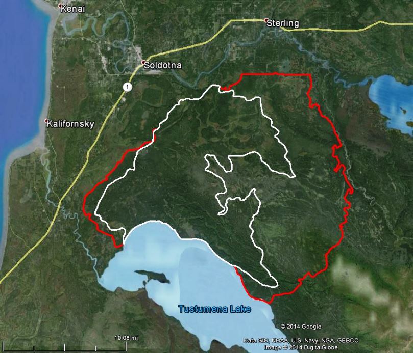
Map of Funny RiverFire May 26, 2014
Map of Funny RiverFire. The white line was the perimeter at 9 p.m. May 23. The perimeter at 4 a.m. May 26 is shown in red.

The incident management team running the Funny River Fire at Soldotna, Alaska reported the fire has burned 158,585 acres and it is 30 percent contained. It crossed the Kenai River Sunday afternoon near Torpedo Lake just east of the Kenai Keys. Several spot fires within the Keys did minor damage but were quickly put out. The team is working to confirm if any structures were lost. The wind driven fire is continuing to spread northeast towards the Skilak Lake Road. The Lower Skilak Lake Campground was evacuated and is closed until further notice. The Kenai Keys area is under an evacuation advisory. The weather forecast is calling for rain early Tuesday. Cooler and wet weather will help slow fire activity.

Continue reading “Alaska: Funny River Fire becomes megafire”