The state of Colorado is working on a system that would use drones to provide live video of wildfires to wildland firefighters’ cell phones. The Center of Excellence for Advanced Technology Aerial Firefighting is beta testing a DVI Mavic drone that would push the real time video to firefighters using software developed by the military, Android Team Awareness Kit (ATAK).
The program has the capability of displaying data from tracking devices carried by soldiers, or firefighters, and identifying their location on a map, which in this case could also show the fire in real time.
If they are successful in developing and implementing a system that can provide to fire managers real time information about the location of a wildfire AND firefighting resources, it would achieve what we call the Holy Grail of Wildland Firefighter Safety — knowing those two elements of information.
The DJI Mavic can only stay in the air for 20 to 30 minutes before having to return to base to replace the battery. So this beta test is probably only a proof of concept attempt, perhaps leading to a more robust drone, rotor or fixed wing, that could stay in the air for a much longer period of time.
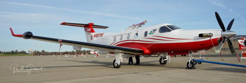
“https://wildfiretoday.com/wp-content/uploads/2017/06/PilatusPC12.jpg”> One of the two State of Colorado’s Pilatus PC12’s, was photographed in March of 2016 in Sacramento.[/captioColorado already has the ability to transmit near real time imagery of fires from their two MultiMission Aircraft, Pilatus PC12’s. They are integrated with the Colorado Wildfire Information System, a geospatial database that displays incident images and details to local fire managers through a web based application.
Technosylva has released a new free app for smart phones that can help predict fire behavior. It is called Wildfire Analyst Pocket and is available for Android phones. It will soon be on the Apple app store as well.
In a video filmed May 21, 2018, the president of the company, Joaquin Ramirez, introduces us to the app.
Technosylva is one of the companies that produce systems available now that could lead toward the Holy Grail of Wildland Firefighter Safety, tracking in real time the location of firefighters and a wildfire.
Senate Bill 2209 would enhance situational awareness for firefighters
Smoky conditions on the Legion Lake Fire in Custer State Park in South Dakota, December 12, 2017. Photo by Bill Gabbert.
Two U.S. Senators are co-sponsoring a bill that would enhance the safety and situational awareness of wildland firefighters. Senate Bill 2290 would be an important step toward what we have called the “Holy Grail of Firefighter Safety”. This concept would provide the real time location of a wildfire and the resources working on the incident. Too often fatalities have occurred when firefighters did not know where the fire was or overhead personnel were not aware of the position of firefighters who were endangered by the quickly spreading fire. Or both at the same time.
The legislation would require the Departments of Interior and Agriculture to jointly develop and operate “a tracking system to remotely locate the positions of fire resources assigned to Federal Type 1 Wildland Fire Incident Management Teams”.
A complimentary requirement in the bill is “unmanned aircraft systems to [supply] real-time maps, detect spot fires, assess fire behavior, develop tactical and strategic firefighting plans, position fire resources, and enhance firefighter safety”.
The sponsoring Senators are a Democrat and a Republican, Maria Cantwell (D-WA) and Cory Gardner (R-CO). Since the bill was introduced January 10, 2018 no further action has taken place and no additional Senators have signed on, so it appears there is not much momentum pushing it through the process.
Washington D.C. —U.S. Senators Cory Gardner (R-CO) and Maria Cantwell (D-WA) introduced the Wildfire Management Technology Advancement Act of 2017, a bill designed to bring firefighting agencies into the 21st century.
This bill will increase firefighter safety by requiring the Forest Service and the Department of the Interior to begin providing GPS locations for crews on wildfires and to begin using Unmanned Aircraft Systems to scout out and map wildfires in real-time. Wildfire Today refers to the simultaneous use of mapping aircraft and GPS locators as the ‘Holy Grail’ of firefighter safety.
It is nice to see that at least two Senators are thinking about firefighter safety.
Thanks and a tip of the hat go out to Bean. Typos or errors, report them HERE.
The system will enhance situational awareness for 1,200 firefighting resources.
Above: an example of a mobile data terminal made by Radio Mobile.
(Originally published at 10:50 a.m. MT February 15, 2018)
The California Department of Forestry and Fire Protection (CAL FIRE) has signed a contract to provide technology in 1,200 state-owned vehicles that will facilitate mission critical data communications over a variety of networks (broadband, narrowband and satellite).
Under the agreement, RadioMobile will provide a centralized location tracking application within a mobile data terminal solution. The system receives incident information, provides mapping, and enables vehicle operators to communicate via a touchscreen application interfacing with their computer aided dispatching (CAD) system. The company will also provide the equipment, services, and support needed to implement a statewide VHF mobile data system and integrate network switching between broadband/cellular, VHF and satellite for CAL FIRE mobile resources.
We have been an advocate for the Holy Grail of Wildland Firefighting, which is knowing the real time location of firefighters and the fire. This system will implement a portion of that, tracking the location of firefighting vehicles and other mobile equipment (but probably can’t track dismounted personnel). It will also have the capability of displaying a map, and when data is available it could show the location of the fire. For example, it could show a sketched-out hand drawn map of the fire, or live video from an air attack ship or drone orbiting 10,000 feet over the fire. And, importantly, it could indicate the location of all firefighting resources that have location tracking enabled.
When these functions are implemented, it will enhance the situational awareness of firefighters. Congratulations to CAL FIRE for taking a step to make their personnel just a little bit safer.
This is a screen shot from a Radio Mobile “about us” video. Notice anything interesting?
We have often advocated the Holy Grail of Wildland Firefighting, which is knowing the real time location of firefighters and the fire.
There are many different technologies and platforms for collecting and displaying data about the location of the fire, but the information collected has yet to become commonplace in the hands fireline supervisors on the ground.
A similar situation exists for tracking the location of firefighting resources — personnel and equipment. The technology has existed for years, but the “deciders” in the National and State capitals have not recognized its importance for providing situational awareness, so it is only being used in a few scattered areas.
The Colorado Center of Excellence for Advanced Technology Aerial Firefighting (yes, they are still using that name) recently evaluated and tested two consumer-level personal tracking devices, the SPOT Gen3® and the Garmin inReach® (formerly known as the DeLorme inReach).
The executive summary from their report is below. The full document can be downloaded HERE.
Executive Summary
Wildland firefighters frequently operate in remote areas and are often a significant distance away from their supervisors or other nearby units. Additionally, wildland firefighters typically communicate with voice radios operating in analog mode, which does not facilitate location tracking or other digital situational awareness. One technology proposed to overcome these limitations and provide GPS location tracking and messaging for firefighters is satellite messengers. The Center of Excellence for Advanced Technology Aerial Firefighting (CoE) was requested to conduct a study of these devices to analyze their utility for firefighters. This study illustrated the technical specifications of two consumer-grade satellite messengers, the SPOT Gen3® and the Garmin inReach® (formerly known as the DeLorme inReach), and provided information on service options and costs. The study also assessed the capabilities of the SOS feature common to both devices and employed field trials to evaluate the performance of the devices in various types of vegetation and terrain.
The CoE found that the SPOT device provides a one-way flow of information from the device user to others using predesignated email addresses, text messages, or website access. This device requires programming ahead of use to designate the time interval for location tracking, as well as the content of the three types of messages it can send. The inReach device provides a two-way flow of information, with others able to communicate with the device user via email, text message, or website.
The SPOT device successfully transmitted a test SOS message from a meadow with a clear view of the sky, which then led to the Colorado Division of Fire Prevention and Control Duty Officer being notified of the SOS within 3 minutes. The SOS testing scenario was on a prescribed pile burn under the control of the area interagency fire management unit and the plan was for the Duty Officer to contact the interagency dispatch center regarding the SOS and have them establish radio contact with the unit in distress. Unfortunately, the phone system at the dispatch center was down during the test and no notification could be made. The CoE recommends that for mission-critical applications like wildland fire, the SOS feature be tied directly into relevant computer-aided dispatch systems—a complex requirement for interagency centers that frequently host firefighters from off-unit and from a variety of agencies.
To determine the utility of the satellite messengers for personnel tracking, six field trials were conducted—two each in minimal, moderate, and heavy forest canopy. For each level of canopy, one test was conducted in rolling terrain and one in rugged terrain. These tests sought to establish the rate at which the location of a firefighter walking the perimeter of a simulated 100-acre fire with both devices set on a 5-minute tracking interval would be known to a supervisor watching in real-time via an Internet connection.
The CoE determined that both devices can transmit location information successfully with minimal delays when used under minimal and moderate forest canopies. However, under a heavy forest canopy the devices experienced difficulties. The SPOT device failed to transmit 20% of points and the inReach device took more than 5 minutes to transmit 50% of points (and during one test, failed to transmit 35% of points). The CoE recommends shortening the tracking interval when operating under heavy forest canopies to increase the odds of successful transmissions and cautions against relying solely on these devices to achieve situational awareness for firefighters operating under heavy forest canopies.
The Colorado Division of Fire Prevention and Control is working on a system that could assist wildland firefighters on the ground by reporting their location as well as displaying current maps and real time aerial video of the fire.