President Biden visits National Interagency Fire Center

In Boise, Idaho

5:08 p.m. PDT Sept. 13, 2021

President Biden at NIFC Sept. 13, 2021
President Biden at NIFC Sept. 13, 2021.

President Biden visited two locations in the West Monday to gather information about the current wildfire situation. His first stop was in Boise where he became the first US President to visit the National Interagency Fire Center since it was created 50 years ago.

During a tour of NIFC he talked with a group of smokejumpers and the President was seen holding a pulaski fire tool. Later, sitting in front of what looked like shelves of parachutes he met with Idaho Governor Brad Little, George Geissler of the National Association of State Foresters, and Grant Beebe, BLM’s Assistant Director for Fire and Aviation. The President said Senators Ron Wyden and Jeff Merkley intended to be there but their flight was cancelled due to weather.

President Biden at NIFC Sept. 13, 2021
President Biden at NIFC Sept. 13, 2021.

Mr. Biden praised wildland firefighters for the work they do and reiterated that he is committed to raising their pay. The full text of his public remarks at Boise are below, but here is an excerpt:

The fact is that we’re in a situation where too many memorials are — have been held. And I’ve directed my administration to provide for pay bonuses and incentives to ensure every federal firefighter — because that’s the only authority I have — makes at least $15 an hour. I mean, they should make a hell of a lot — heck of a lot more, but at least $15 an hour. And I’m committing to work with Congress to raise the pay gap for federal wildland firefighters.

And so, you know, believe it or not, there’s massive shortage of fire hoses. I think you all get it. But the idea that we went into this fire season with a shortage of fire hoses — that’s all I heard from my guys back East and in the Midwest: no fire hoses.

Well, fortunately, they thought a long time ago about a thing called the National Defense Act. And what I was able to do — excuse me, the Defense Production Act.

And I was able to restart production of bringing — bringing a lot of people back to work, delivering 21,920 new feet of fire hose in the frontlines, putting a company back to work that was out of business that stopped — stopped manufacturing.

The Associated Press reported Monday that the administration’s use of the Defense Production Act helped an Oklahoma City nonprofit called NewView Oklahoma, which provides the bulk of the U.S. Forest Service’s hose, obtain needed supplies to produce and ship 415 miles of fire hose. If that is correct, two zeros should be added to the 21,920 feet mentioned by the President, making it 2,192,000, which is 415 miles.

President Biden at NIFC Sept. 13, 2021
President Biden at NIFC Sept. 13, 2021. L to R: Idaho Gov. Brad Little, President Biden, Grant Beebe (BLM).

About two hours after Air Force One landed, it departed for Mather Air Force Base near Sacramento. After landing he visited California’s Office of Emergency Services and received a briefing on the wildfires in the state. At one point a map of the Caldor Fire was displayed on a large screen. The plan was for the President to then take an aerial tour of a fire in El Dorado County, the location of the huge 210,000-acre Caldor Fire. And following that, more public remarks about wildland fire.

President Biden receives briefing about the Caldor and other fires
President Biden receives briefing about the Caldor and other fires in California after flying to Mather AFB, Sept. 13, 2021.
President Biden receives briefing about the Caldor and other fires
President Biden receives briefing about the Caldor and other fires in California after flying to Mather AFB, Sept. 13, 2021.

Below is the text of the Presidents public remarks while at NIFC September 13, 2021, provided by the White House:


12:08 P.M. MDT

MR. BEEBE: Mr. President, on behalf of the wildland fire community, I’m proud to welcome you to the National Interagency Fire Center — or NIFC, for short. And we always say NIFC is a place, not an organization.

THE PRESIDENT: (Laughs.)

MR. BEEBE: We’re incredibly proud of it.

Thank you for coming. We’re honored you’re the first President to visit in the 50-year history of the Fire Center, and it’s quite an honor.

I’m Grant Beebe. I’m the Bureau of Land Management’s Assistant Director for Fire and Aviation. And speaking for all the NIFC partners, I’d like to thank you particularly for being here and for your genuine and intense interest in wildland fire management.

I just want to point out: This is a coalition of partners. We have a team here. We have National Park Service, DOD, Fish and Wildlife Service, Bureau of Indian Affairs, National Association of State Foresters representing the states, FEMA, U.S. Fire Administration, and, of course, U.S. Forest Service, Fish and Wildlife Service.

I think I got them all; somebody will correct me. Oh, and of course, National Weather Service — one of the original partners here at NIFC. The inception of this was a Forest Service, BLM, NOAA, Fish and Wi- — National Weather Service operation.

So, we’re incredibly proud of it. We’re so proud to have you here.

NIFC was created 50 years ago, and it is the original and durable model for interagency, intergovernmental coordination. Extremely lengthy, intense, and damaging fire seasons like the one we’re experiencing now reinforce the purpose of places like this.

Through the hard work, ingenuity, and persistence of generations of fire professionals, wildfire response across the nation is unified, cooperative, and professional. And I’ll say that we all stand on the shoulders of giants. We inherited this place, and we’re trying to keep it going.

In wildland fire, there’s no one community, agency, Tribal organization that has enough resources to manage all of its fires. Fires don’t know jurisdictional boundaries, and we try to ignore jurisdictional boundaries ourselves. One of our speakers will speak to that particularly.

But the kind of fires we’re experiencing these days — the kind of long-duration, massive, destructive fires we’ve witnessed in recent years in places like California, Oregon, Washington, Colorado, and, unfortunately, for Governor Otter [sic] this year, in Idaho — they’re teaching us that we need to maybe change the way we’re doing business.

Continue reading “President Biden visits National Interagency Fire Center”

Satellite photo, wildfires in the Northwest, July 29, 2021

Satellite photo smoke wildfire
Satellite photo 7:10 p.m. PDT July 29, 2021

The wildfires in Southeast British Columbia, Northern Washington, Northern Idaho, and Northwest Montana were putting up a lot of smoke Thursday at 7:10 p.m. PDT. NASA GOES 17.

Suspect fires handgun at airport in Idaho, firefighters flee

A 911 caller said the suspect was attempting to steal a helicopter

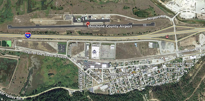
Map, Shoshone County Airport
Map, Shoshone County Airport. Wildfire Today / Google Earth.

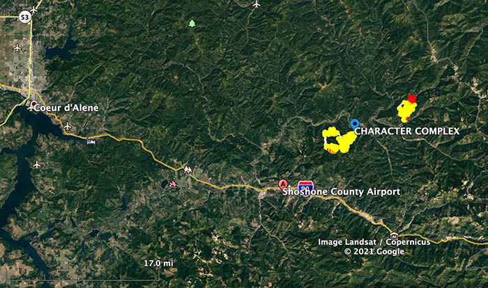
On Saturday July 17, wildland firefighters at the Shoshone County Airport in Smelterville, Idaho 30 miles southeast of Coeur d’Alene, encountered a dangerous situation that is not covered in the dozens of training courses they take.

From the Shoshone County Sheriff’s Office:


At approximately 5:52pm, Shoshone County Sheriff’s Office (SCSO) dispatch received a 911 call reporting an armed subject approaching fire personnel in their helicopter at the Shoshone County Airport in Smelterville Idaho. A second 911 caller reported the subject was attempting to steal a helicopter.

At the airport during this incident, there were between 30 to 70 fire fighter personnel present on scene due to the local active fires.

At approximately 5:57pm, a SCSO Deputy arrived on scene and quickly located the armed suspect (Oregon resident). The suspect then discharged a handgun several times into the ground and air as fire fighter personnel were fleeing the immediate area. The SCSO Deputy ordered the suspect to drop the weapon, he complied soon after and was taken into custody with the assistance of a 2nd SCSO Deputy and an Idaho State Police Trooper without further incident. Several other SCSO units and other law enforcement agencies arrived shortly after.

For clarification, NO law enforcement officers discharged a firearm and no one was injured during this incident.

The investigation is ongoing and no further information will be released at this time.

End of Shoshone County Sheriff’s Office report.


In the video below, the narrator says he’s at the Kellogg, Idaho airport. Kellogg is immediately east of Smelterville.

Map, Shoshone County Airport
Vicinity map, Shoshone County Airport. Google Earth.

Snake River and Dry Gulch Fires very active in Washington and Idaho

8:30 a.m. MDT July 12, 2021

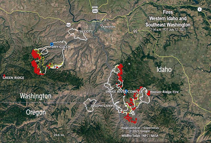
map Dry Gulch Fire and Snake River Complex
Map of the Dry Gulch Fire and Snake River Complex of fires. The red areas represent heat detected by a satellite at 2:54 a.m. MDT July 12, 2021.

Wildfires are still very active where three states meet, Washington, Oregon, and Idaho.

Dry Gulch
Nearly all of the spread of the fire over the last two days has been on the southwest side. A mapping flight Sunday night found that it had grown to 55,050 acres, but has moved no closer to Lewiston, Idaho and is still 10 miles southwest of the city. The Dry Gulch Fire merged with the Lick Creek Fire on July 8 and they are now treated as one — Dry Gulch.

On Sunday evacuation warnings ( Level 2, get set) were in effect, but no actual evacuation orders (Level 3, leave now). (Very Brief Editorial: We need a national system of evacuation criteria that is uniform across the country, makes sense, and does not require training or explanation!)

Dry Gulch Fire, July 9, 2021.
Dry Gulch Fire, July 9, 2021. InciWeb photo

The Dry Gulch Fire has been managed by a Type 2 Incident Management Team, but a Type 1 Team will assume command Monday, July 12.

Resources assigned on Sunday evening included 14 hand crews, no helicopters, 52 fire engines, and 4 dozers for a total of 536 personnel.

Snake River Complex
The 54,407-acre fire 12 miles south of Lewiston, Idaho is being managed by a Type 2 Incident Management Team. It is comprised of three fires that burned together, Shovel Creek, Captain John Creek, and Hoover Ridge. The growth over the last two days has been closer to each other as well as to the east and the south. It is bordered on the west side by the Snake River. The greatest spread Sunday was on the south side where the Shovel Creek Fire came close to the Salmon River. The east side of the Hoover Ridge Fire is being held by the Salmon River.

Approximately 438 residences are threatened.

From the Incident Management Team Sunday evening:

On the north end of the fire, resources continue to protect values at risk including primary structures and infrastructure around Waha Lake and Red Bird road. Tactics include a combination of indirect line followed up with burning in Madden Creek and around to the south. In the Craig Mountain area, resources are completing indirect fireline to the north. The Hoover Ridge fire resources continue to secure the northeast corner down to the Salmon River. Resources are still using a point protection strategy to burn around and secure values at risk in both the Salmon and Snake Rivers.

Resources assigned Sunday evening included 3 hand crews, no helicopters, and 6 fire engines for a total of 170 personnel.

Dixie Fire
The 15,323-acre Dixie Fire just east of Dixie, Idaho is not being completely suppressed by the Nez Perce-Clearwater National Forest. It is being managed by a Type 1 Incident Management Team. Resources that are 15% monitoring, 30% confining, 35% point protecting, and 20% suppressing the fire include 8 hand crews, 16 fire engines, and 4 helicopters for a total of 522 personnel. The same team is managing the nearby 898-acre Jumbo Fire. (map)

Wildfires in Western Idaho and Southeast Washington continue to grow

Wildfires in Southeast Washington and Western Idaho
Wildfires in Southeast Washington and Western Idaho. The red areas represent heat detected by a satellite at 4:12 a.m. PDT July 10, 2021.

The fires in Western Idaho and Southeast Washington were very active Friday and into the night.

The Shovel Creek Fire east of the Snake River merged with the Captain John Creek Fire just to the north, 13 miles south of Lewiston, Idaho. It is being managed with the Hoover Ridge Fire 5 miles to the east in what is now the Snake River Complex of fires. Together, they have burned 31,900 acres. On Saturday the Type 3 Incident Management Team is transitioning to the Type 2 Northern Rockies Team 4. The plan for Saturday is to establish an operational strategy and continue point protection. Boats are being used to shuttle firefighters on the Snake River.

(To see all articles on Wildfire Today about the wildfires in Southeast Washington and West Idaho, including the most recent, click HERE.)

Snake River Complex fires
Snake River Complex July 9, 2021. InciWeb photo.

The Dixie Fire is just east of the small community of Dixie, Idaho, east of Road NF-222. Friday night it was mapped at about 13,000 acres. It is burning in mixed conifer stands with 40-60% standing dead trees in some areas. Old fire scars with heavy accumulations of down fuels are slowing the fire but are not barriers to fire spread. Long range spotting is occurring. If the fire activity increases, the incident management team said, it could prompt structure protection in the communities of Dixie and Comstock, and along the Salmon River at the Jim Moore and Whitewater Ranches.

The 1,300-acre Jumbo Fire is seven miles west of the Dixie Fire. They are both being managed by the Type 1 Northern Rockies Incident Management Team 2.

In Washington the lightning-caused Dry Gulch and Lick Creek Fires 9 miles southwest of Lewiston, Idaho merged and are now known as the Dry Gulch Fire. It  has burned about 38,000 acres, an increase of 13,000. Structures are threatened and evacuations are in effect. Most of the growth Friday was to the southwest where it is moving into higher elevations and heavier vegetation.

Multiple large fires in Western Idaho

And Southeast Washington

10:41 a.m. MDT July 9, 2021

Western Idaho Fires July 9, 2021

The fires in Western Idaho and Southeast Washington were very active and continued to expand Thursday night.

The Shovel Creek Fire east of the Snake River 20 miles south of Lewiston, Idaho was mapped at 16,066 acres. It is being managed by a Type 3 Incident Management Team led by Incident Commander Miller.

(To see all articles on Wildfire Today about the wildfires in Southeast Washington and West Idaho, including the most recent, click HERE.)

The Captain John Creek Fire is just north of the Shovel Creek Fire and the two are likely to merge. By our estimate it has burned at least 5,000 acres based on satellite imagery.

The Hoover Ridge Fire is 25 miles south of Lewiston, 6 miles east of the Shovel Creek Fire. We estimate it has burned about 2,000 acres.

Satellite photo Northwest U.S. smoke fires
Satellite photo showing smoke from wildfires in the Northwest U.S., at 7:30 p.m. MDT July 8, 2021. NASA.

The Dixie Fire is just east of the small community of Dixie, Idaho, east of Road NF-222. On Thursday it had burned about 11,000 acres but has grown since then.

The 1,300-acre Jumbo Fire is seven miles west of the Dixie Fire. They are both being managed by the same Type 1 Incident Management Team, Northern Rockies Team 2.

In Washington the lightning-caused Dry Gulch and Lick Creek Fires 9 miles southwest of Lewiston, Idaho merged and are now known as the Dry Gulch Fire. Friday morning the revised size was 19,346 acres due to more accurate mapping. The fire behavior is being described as extreme, structures are threatened, and evacuations are in effect.


8:02 p.m. MDT July 8, 2021

Northern Idaho Fires, July 8, 2021
Northern Idaho and Southeast Washington Fires, July 8, 2021

The lightning that came through Washington, Idaho, and Montana Tuesday and Wednesday started many wildfires, in large part due to the dry fuels and the fact that little or no rain accompanied the lightning.

On July 7, 106 new fires were discovered in the Northern Rockies Geographic Area which includes Northern Idaho, Montana, and North Dakota.

The area where three states converge, Idaho, Oregon, and Washington, has seen a lot of wildfire activity over the last two days. Some of the blazes started yesterday, July 7, and may be related to the dry lightning, but the causes for all fires have not been determined.

The Shovel Creek Fire started from lightning July 7 and has burned at least 6,000 acres in Western Idaho just east of the Snake River very close to the point where the three states meet. It is 20 miles south of Lewiston, Idaho. The river is the boundary between Idaho and the other two states. The fire is being fully suppressed by the Northern Rockies Team 4, with Incident Commander Connell.

There are two other large fires near the Shovel Creek Fire in Idaho — one is two miles north, about 1,100 acres, and the other is six miles east, approximately 1,300 acres. We were not able to determine the name of those two.

The 11,000-acre Dixie Fire is just east of the small community of Dixie, Idaho, east of Road NF-222. It has been burning since July 5 and is being managed by a Type 1 Incident Management Team which is expected to assume command July 9. The team’s strategy is four-fold, 25 percent each: monitor, confine, point protection, and suppression.

The Jumbo Fire has burned about 571 acres 8 miles west of the Dixie Fire. It started from lightning July 6 and is being managed by a Type 3 Team led by Bransford. They have multiple strategies: monitor, confine, and point protection.

There are two large fires in southeast Washington about 15 miles southwest of Lewiston, Idaho. Heat detected by satellites at 2:48 p.m. Thursday indicates that they probably have burned together or merged with other blazes. The fire names are Dry Gulch and Lick Creek and they both started July 7 and are being fully suppressed. As of Thursday afternoon the Dry Gulch had burned 27,929 acres and the Lick Creek was last mapped at 1,500. Extreme fire behavior was observed on both.