US wildfires had mix of highs and lows nationwide in 2025, new report shows

The United States had far more wildfires, but far fewer acres burned, than normal in 2025, according to a newly released report.

The National Interagency Fire Center, the home of U.S. wildland fire planning and suppression efforts, released its annual national wildfire report on Friday, which shows just how abnormal 2025 was.

The reported number of wildfires nationwide was noticeably higher than the five and 10-year averages, according to the report. Nearly 77,850 wildfires burned throughout the nation in 2025, compared with the 5-year average of 61,680 and the 10-year average of 62,435.

Conversely, the high number of wildfires burned far under the normal amount of acres nationwide. Wildfires in 2025 burned 5,131,474 acres, below the 5-year average of 7.3 million burned acres and the 10-year average of 7.6 million burned acres.

Southern states, from Virginia to Texas, had just under half of the nation’s total wildfires at 37,088, by far the highest number of reported wildfires compared with any other region in the nation, according to the report. The largest wildfire of 2025 was Dragon Bravo in Arizona, burning 145,504 acres. The southern region also nearly had the nation’s most burned acres at 967,000, second only to the Alaska region with 1,006,000 burned acres, and had over half of the nation’s reported human-caused wildfires at 36,040.

Eastern states, from Maine to Missouri and Minnesota, had by far the highest increases in both reported wildfires and burned acres compared with every other region’s 10-year average. The region’s burned acre total of 241,000 acres was 159% higher than its 10-year average of burned acres, while its reported wildfire total of 15,367 was 50% higher than its 10-year average of reported wildfires.

Center officials processed an above-average number of requests for resources filed nationwide at over 660,000 requests, including critical supply orders. Requests for crew, overhead, and helicopter mobilizations were well above previous averages, while requests for air tankers, engines, and critical incident management team mobilizations fell below averages.

Click here to read the full report.

Cal Fire warns about drones near wildfires

CAL FIRE Issues Urgent Warning Regarding Incursions of Unmanned Aircraft Systems

The state fire agency has issued an urgent warning regarding the incursion of Unmanned Aircraft Systems (UAS) into firefighting airspace. These incursions have raised serious concerns and led to the suspension of critical aerial
firefighting operations on a half-dozen incidents so far this year.

Cal Fire drone incidents this year
Cal Fire incursions by the year

The FAA regularly establishes Temporary Flight Restrictions (TFRs) around wildfire areas to protect the safety of pilots and other aircraft crews working in firefighting operations. All aircraft, including drones, are explicitly prohibited from entering these restricted areas unless they are operated by an agency directly involved in the wildfire suppression efforts. Even when a TFR is not in effect, drone pilots are warned to avoid flying near wildfires — it is considered a crime to interfere with firefighting operations.

“The danger of flying drones near wildfires cannot be overstated,” said Chief Jake Sjolund, Staff Chief Tactical Air Operations. “Such actions jeopardize lives and have immediate consequences for firefighting agencies’ response efforts.”

When drones are detected near wildfires, fire response agencies will ground their own firefighting aircraft to mitigate the risk of a collision. This delay in airborne response on a fire threatens the safety of firefighters on the ground, residents, and properties in nearby communities.

Anyone who operates a drone without authorization near a wildfire can be found in violation of federal, state, and local laws, regulations, and ordinances — regardless of whether a TFR is in place. Anyone who interferes with wildfire suppression efforts with a drone can face severe consequences, including civil penalties of up to $20,000 and even criminal prosecution.


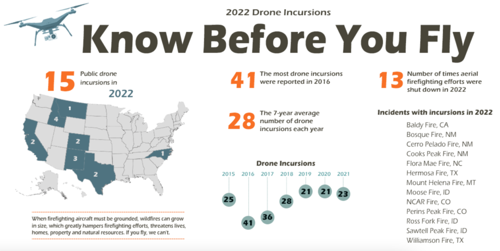
2022 UAS Incursions
2022 national UAS Incursions — NIFC


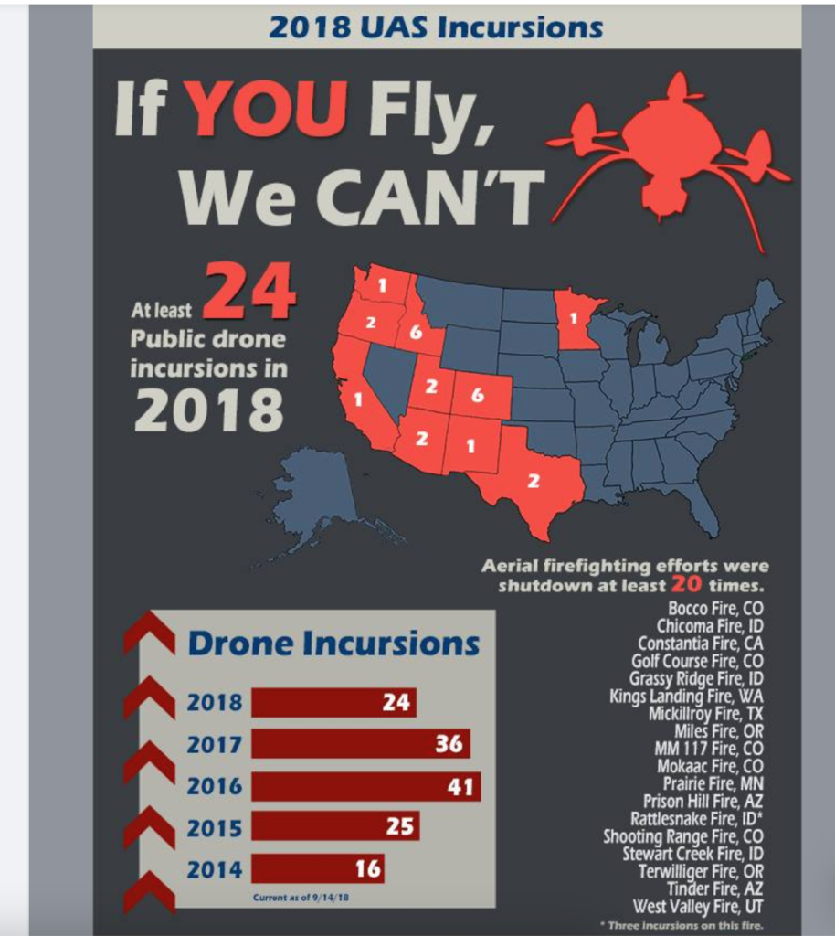
NIFC drone incursions 2018
NIFC drone incursions 2018 — note the NIFC page is no longer at that URL.

41 Companies on $1B Forest Service Helicopter Support Contract

A potential 10-year, $1 billion contract list for helicopter support services to the U.S. Forest Service was announced yesterday.

USFS helicopter contractsAccording to a post on GOVCONWIRE, the indefinite-delivery / indefinite-quantity contract covers the provision of helicopters in the Type 3 category to support national resource conservation and wildland fire management programs. A notice posted Wednesday on the SAM.gov site identifies contractors on the list in a PDF linked from that site.

      • Award Details
      • Contract Award Date: Apr 26, 2023
      • Contractor Awarded Address: Boise, ID USA
      • Base and All Options Value (Total Contract Value): $1,000,000,000.00

Additional details may be available from David P. Hershey at NIFC.

Type 3 helicopters are light rotorwing aircraft that weigh up to 7,000 lbs. and can carry up to nine passengers. These contracted aircraft will support a variety of missions such as fire monitoring and suppression, initial attack, prescribed fire and aerial ignition, short-haul, and rappelling operations. The government may also use the helicopters for law enforcement and administrative flights. The firm-fixed-price contract has a one-year base period along with nine option years.

After the atmospheric rivers, a changing outlook

To interpret a wildland fire outlook can be a bit like posting a scenic photo to Instagram. You share the images and phases that capture the moment, with hopes that these will intrigue us into deeper connections to the months ahead.

AND THE RAIN AND SNOW FELL … From the latest National Significant Wildland Fire Outlook (for February through May 2013, with hints to the future), one image may lay claim to this month’s Instagram shot. The Total Precipitation Anomaly for January 2023 features a piercing finger of deep-green and blue anomalies from the central California coast eastward to upper Wisconsin – this being the precip falling from “multiple moderate to strong atmospheric rivers,” leading to moisture from 150 to more than 400 percent of normal.

January 2023 Precipitation Anomaly.
January 2023 Precipitation Anomaly. https://www.predictiveservices.nifc.gov/outlooks/precip30day.png.

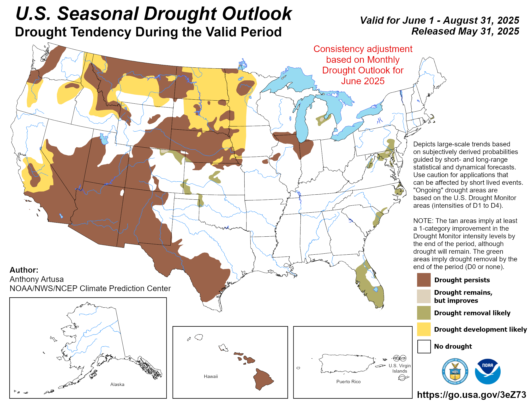
What this means for fire potential long-term is to be determined. Though this was a wide and significant flow, it was not a universal flood. Wide areas are likely to remain in drought yet many regions, including northern California to Oregon and east into Idaho and Montana, are likely to improve, as depicted by the tan (improvement) and green (out of drought) shading in the U.S. Seasonal Drought Outlook through April.

U.S. Seasonal Drought Outlook through April.
U.S. Seasonal Drought Outlook through April. https://www.cpc.ncep.noaa.gov/products/expert_assessment/season_drought.png.

WHAT TO EXPECT: The result of this precip is a fire potential outlook that is nearly Normal by May of 2023, with a slot of Above Normal red from west Texas to central New Mexico and a blob in the Georgia-Florida pinelands.

Significant Wildland Fire Potential Outlook for May 2023.
Significant Wildland Fire Potential Outlook for May 2023. https://www.predictiveservices.nifc.gov/outlooks/month4_outlook.png

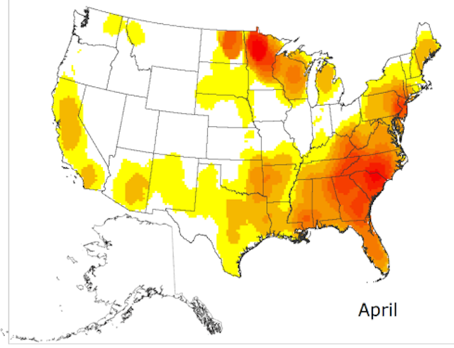
WHAT NORMAL LOOKS LIKE … in a typical season, for March into May, fires (including prescribed fires) may be relatively active on the land, particularly in the Southeast and southern Great Plans into the Trans-Pecos and Rio Grande, as illustrated in this map of normal fire activity for April.

Normal-Fire-Season-Progression-April

Our tracking with “normal” will be influenced by global transitions as we’re likely leaving a record-long period of La Niña conditions. As the Outlook observes: “The Climate Prediction Center (CPC) is forecasting an 82% chance of neutral El Niño-Southern Oscillation (ENSO) conditions returning in spring. Other teleconnection patterns, such as the Madden-Julian Oscillation, Pacific Decadal Oscillation, Pacific-North American Pattern, and Arctic Oscillation are likely to influence weather and climate during the outlook period.” But we’re not through with the cool-ocean pattern yet: “La Niña is forecast to remain the dominant influence through February.”

So expect some variability to be foretold, as fuels grow into green-up and cure into summer.

For more, see the NIFC Predictive Services’ National Significant Wildland Fire Potential Outlook for February through May 2023.

An understatement from NIFC

The National Interagency Fire Center does not bother to publish a daily Situation Report during about half the year, no matter how many wildfires are burning. Their last one was on March 3, 2017.

CNN is reporting that about a million acres have burned in the central plains in the last few days and five people have been killed in the fires. This morning we wrote that three fires alone near the Oklahoma/Kansas border burned over 833,941 acres.

But at least NIFC is giving us SOME information about the fires. At 1:55 p.m. MST on Wednesday they sent this tweet:

nifc fires

Maybe they will say their account was hacked! 🙂

Air tankers positioned at Boise

Tanker 162
Tanker 162 at Boise. NIFC photo.

The National Interagency Fire Center posted these photos on their Facebook page today, with the following text:

What’s Happening at NIFC these days? There are 4 heavy airtankers awaiting assignment, along with 2 SEATS. These pics are of one of the Next Gen Airtankers. In the foreground is the hose on wheels that fills these guys up with retardant!

The air tanker shown above is Aero Flite’s Tanker 162, an RJ85. It does not have an exclusive use contract, but is one of the 22 air tankers that were recently awarded Call When Needed contracts.

NIFC does not say in which aircraft the interior photo below was taken, but we’re guessing it was the RJ85, Tanker 162. They also don’t say when the photos were taken or by whom.

Interior of an air tanker
Interior of an air tanker at Boise. NIFC photo.

“Flames of anxiety” in Boise

NIFC fire
Representatives of the land management agencies in Boise meet in front of a map showing the wildfire situation in Alaska. BLM photo by Randy Eardley.

The Los Angeles Times has an interesting article about some of the decisions that land managers at the National Interagency Fire Center in Boise are making as fires break out in Alaska and other areas this summer. Below is an excerpt:

****

Flames of anxiety at the U.S. fire command center in Idaho

by John Glionna

The map on the large video screen at the far end of the room provides a real-time snapshot of the forest fires raging across the western U.S.

On this morning, the picture isn’t pretty. It’s ominous in a hold-on-to-your-seat way that casts a pall over two dozen fire analysts, meteorologists and forest experts. They see a growing scourge of fierce yellow and red dots, each representing a new fire, and they furrow their brows.

Alaska is burning.

The incident report for this day, Monday, June 22, at the National Interagency Coordination Center — the nerve center for the white-knuckle job of fire-control nationwide — shows the state at Planning Level 5, the highest possible.

Sixty-four new infernos have been sparked since the day before. In all, 12 large fires burn out of control, with 2,000 firefighters already on the ground.

Remote Alaska town threatened by lightning-sparked blaze; wildfires rage in West
In drought-baked California, 49 new blazes erupted in the previous 24 hours. The Lake Fire in San Bernardino has roared for days, and on this Monday is still only 21% contained. Two conflagrations further north — the Corrine fire near Merced and the Sky fire near Yosemite — have closed roads and threatened structures.

The fire watchers here at this wooded high-security complex hail from a phalanx of federal agencies — Forest Service, Bureau of Land Management, National Weather Service, National Park Service, Fish and Wildlife Service and Bureau of Indian Affairs.

Previously, they met once a month to pool resources, manpower and ideas. Now they huddle daily. Soon they will meet twice a day…”