Fires grow in Oregon and Northern California

Above: This natural-color satellite image was collected on July 18, 2018. Actively burning areas, detected by thermal bands, are outlined in red. NASA image courtesy NASA/Goddard Space Flight Center Earth Science Data and Information System (ESDIS) project.

By Lynn Jenner, NASA

In Oregon there are 15 large ongoing fires and 231,278 acres have been burned as of August 20, 2018. The satellite image above shows several of the larger fires in both Oregon as well as California. California has 10 large fires including the two largest to date, the Ferguson fire and the Mendocino Complex. California has seen 716,276 acres burned this year.

In Oregon, the Taylor Creek and Klondike Fires are burning in the Rogue River-Siskiyou National Forest. Both fires were started by lightning on July 15. These two fires were split into zones on Saturday, Aug. 18. The fires are now referred to as “Taylor Creek and Klondike East Fires,” managed by the Alaska Incident Management Team and the “Klondike West Fire” which is managed by California Interagency Incident Management Team 4. California Interagency was called in to continue with the aggressive fight to fully suppress the fire. That will allow the Alaska Incident Management Team to focus its effort on controlling the southeast corner of the fire that is directly threatening the communities of Selma and Cave Junction. As of the morning of Aug. 20, the Taylor Creek Fire is estimated 52,588 acres and is 79 percent contained. The Klondike Fire is estimated at 72,074 acres and is 28 percent contained.

The Miles Fire is the new name for the fire previously named the Sugar Pine. The Miles Fire and Sugar Pine fire have merged. On Sunday July 15, lightning started hundreds of fires across Southwest Oregon. The Miles fire has currently affected 47,015 and is 38% contained at present. Today some instability will swing into the area with the threat of some isolated showers or a thunderstorm. Continued smoke in the valleys will moderate daytime temperatures but will also continue to affect air quality for local communities.

The Watson Creek fire is currently burning on the Paisley Ranger District of the Fremont-Winema National Forest. It was discovered Wednesday, August 15 at 2:15 p.m. The fire is currently burning in heavy fuels, primarily dead and down lodge pole pine. This fire has burned 25,778 acres. The cause of the blaze is under investigation.

In California, right on the Oregon/California line between Happy Camp, CA and Cave Junction, OR is the Natchez fire which has been burning since lightning struck on July 15, 2018. The 697 personnel assigned to the incident are working to implement suppression actions that will most effectively and safely limit fire growth. Currently 20,275 acres have burned and the fire is 70% contained. Fire area closures are in place on the Rogue River-Siskiyou and Klamath National Forests.

The Stone fire began on August 15 with a lightning strike. The current fire size 22,610 acres. Weather concerns for this fire include extremely dry conditions and low humidity. The fire was active last night and fire crews made great progress along the fire edge to control the fire spread and provide structure defense.

Update on Southwest Oregon fires

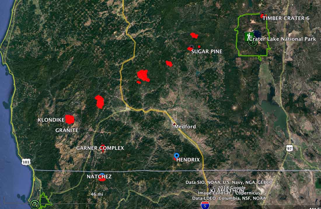
Here is a VERY brief update on the wildfires burning in Southwest Oregon.

On the map above the red dots are the most recent, representing heat detected by a satellite at 3:31 a.m. PDT July 28, 2018.

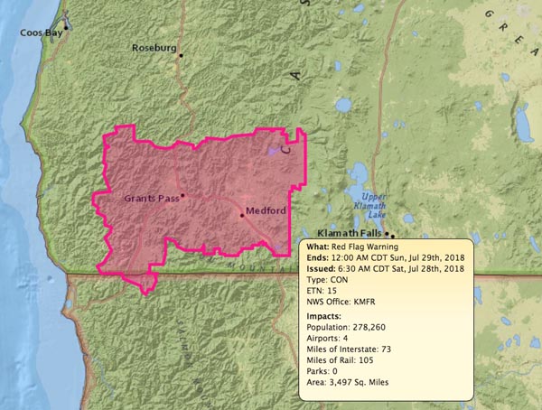
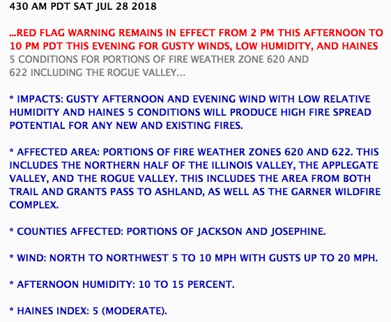
The area around Bend and Medford is under a Red Flag Warning Saturday for low relative humidity, gusty winds, and unstable atmospheric conditions.

Red Flag Warning
Red Flag Warning, July 28, 2018.
Red Flag Warning
Red Flag Warning, July 28, 2018.

Fires in Southwest Oregon were very active Sunday

Above: The map of Southwest Oregon shows heat on wildfires detected within the last week. The red dots are the most current.

(Originally published at 10 a.m. PDT July 23, 2018)

Firefighters in Southwest Oregon are still battling wildfires ignited by the lighting storms that passed across the state a week ago. The good news is they got a reprieve Sunday when additional lightning that was predicted didn’t show up.

Here is a brief summary of the fire situation in Oregon prepared by the Northwest Coordination Center Monday morning:

The warming and drying trend in Oregon will continue [Monday]. This trend is moving north into Washington. Smoke covered the Southwest Oregon fires through the morning [Sunday] and cleared out by early afternoon. As the smoke cleared, large fires in Southwest Oregon exhibited more active growth through the afternoon and into the evening.

Four Incident Management Teams are prepositioned in the Geographic Area and ready for assignments if needed: NW Team 7 (Knerr), NW Team 8 (Johnson), NW Team 10 (Lawson), and PNW Team 2 (Schulte).

The Garner Complex consists of six fires east of Cave Junction. Together they have burned over 11,000 acres. Sunday 50 Oregon National Guard personnel arrived to staff ten road blocks around the clock.

The 1,200-acre Timber Crater 6 Fire in Crater Lake National Park is one of several fires ignited by lightning in and around the Park July 15. On Monday the Incident Management Team described their situation:

With the number of new fires in the Northwest this week, firefighting resources are strained. However, the Timber Crater 6 Fire is being aggressively managed for full suppression, commensurate with values at risk and the overriding objective of public and firefighter safety.

Interesting pattern of wildfires in Southwest Oregon

lightning fires southwest Oregon
Click to enlarge.

These fires in Southwest Oregon are arrayed in an interesting pattern. Most if not all of them I believe were caused by some of the 2,800 lightning strikes in the state last weekend. It makes you wonder if they were generated by an intense thunderstorm cell that moved northeast across that part of the state.

The red dots represent heat detected by a satellite at 3:59 a.m. PDT Saturday July 21.

United States and Canada share firefighting resources

Above: Saskatchewan air tanker 474 lands at Medford, Oregon July 19, 2018.

Tim Crippin shot these photos of firefighting aircraft arriving at the Medford, Oregon airport July 19. The two air tankers and the Bird Dog aircraft are owned by the government of Saskatchewan. The planes were mobilized through the Pacific Northwest Compact to Oregon; it was not an action that was taken by the National Interagency Coordination Center (NICC).

Saskatchewan Bird Dog 161
Saskatchewan Bird Dog 161 lands at Medford July 19, 2018.

The Canadians use “Bird Dog” aircraft in a role similar to lead planes in the United States. A Bird Dog usually works with two air tankers as a three-aircraft module. This one, 161, is an Aero Commander 690D.

Saskatchewan air tanker 471
Saskatchewan air tanker 471 lands at Medford, Oregon July 19, 2018

In addition to these three aircraft, other firefighting resources have been flowing across the international boundary in recent weeks from the U.S. to Canada:

  • NICC dispatched 12 wildland federal firefighters to Ontario, Canada.
  • The Northeast Compact sent resources to Ontario including three Type 2IA crews from New Hampshire, Maine and Massachusetts. However, the New Hampshire and Maine crews were demobed earlier this week and the Massachusetts crew will be demobed on Sunday.
  • Maine will be sending a second Type 2 IA crew to Ontario on Saturday.
  • The Great Lakes Compact has sent to Ontario 10 single resources (2 aviation managers and eight firefighters).
  • Wisconsin State will be mobilizing eight firefighters also to Ontario, Canada.

No aircraft have been sent to Canada from the U.S.

One dead, 50,000 acres burn in Substation Fire

Northern Oregon southeast of The Dalles

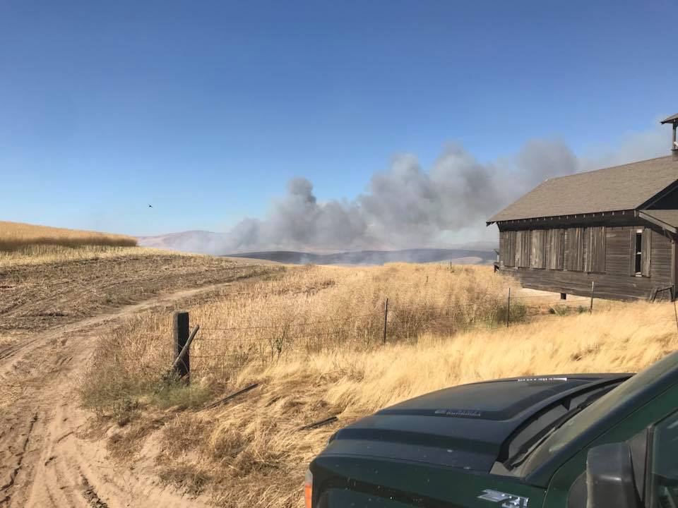
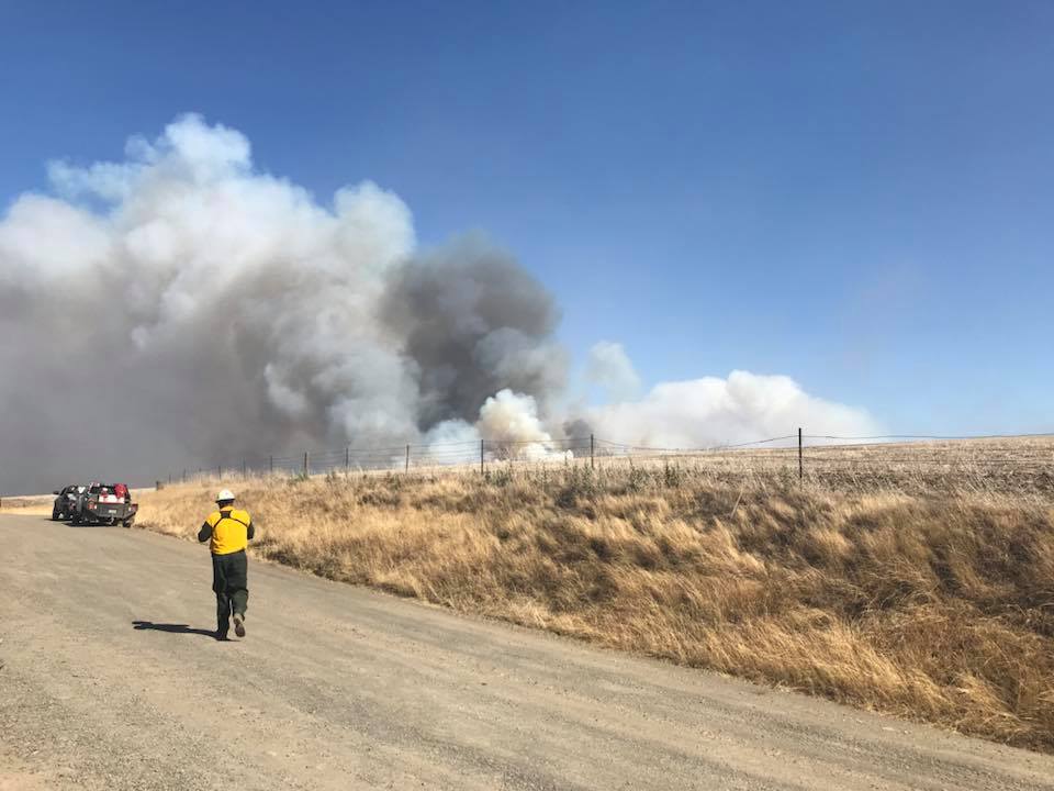
Above: Substation Fire. Incident Management Team photo, July 18, 2018.

(Originally published at 6:33 a.m. PDT July 19, 2018)

Since the Substation Fire started July 17 southeast of The Dalles, Oregon it has claimed the life of one person and burned over 50,000 acres. The fire has blackened an area approximately 18 miles long by 8 miles wide, and has jumped the Lower Deschutes River in at least two places.

The Wasco County Sheriff’s Office reported that at 1:30 p.m. on July 18 deputies answered a call about a burnt tractor. They found the operator a short distance away, deceased, apparently killed by exposure to the fire. The operator may have been attempting to suppress the fire by using the tractor and disk to construct a fireline. The release of the person’s name is pending notification of next of kin.

The Sheriff’s Office has the most current information about the areas under evacuation orders. They have boats patrolling the river to notify hikers and boaters.

Officials have closed Highway 97 from Biggs Junction to Highway 197.

The Governor declared the fire a conflagration Wednesday, which allows the state fire marshal to mobilize firefighting resources.

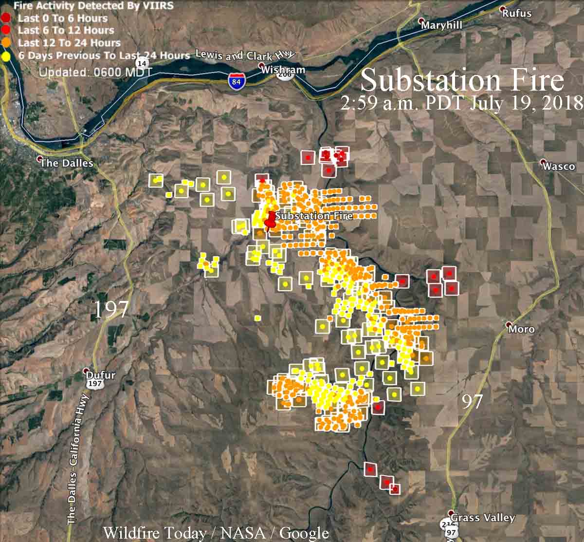
map substation fire
Map showing heat on the Substation Fire detected by satellites as late as 2:59 a.m. PDT July 19, 2018. The red icons are the most current. It is likely that in some areas light fuels such as wheat and grass burned and cooled in between satellite overflights, therefore was not detected by the sensors. Click to enlarge.

The area is under a Red Flag Warning on Thursday. The forecast for the fire area calls for 78 degrees, 25 percent relative humidity, and afternoon winds out of the northwest of 19 gusting to 27 — not good news for firefighters.

A Type 1 Incident Management Team (Schulte) has been assigned to the fire.

One structure has been destroyed, an often photographed historic home.

Substation Fire
Substation Fire. Incident Management Team photo, July 18, 2018.
Substation Fire
Substation Fire. Incident Management Team photo, July 18, 2018.

The video below was uploaded by the Incident Management Team to Facebook on July 18, 2018.