Wildfire potential, for 2013

Wildland Fire Potential, 2013

The map above is an attempt by the U.S. Forest Service to quantify by location the potential, this year, of wildfires that that would be difficult for suppression resources to contain. Areas with higher values have a higher probability of experiencing high-intensity fire with torching, crowning, and other forms of extreme fire behavior.

A much larger zoomable version of the map can be found here (1.5MB). (It becomes more interesting when you click to zoom in to see more detail.)

At their web site, the USFS does not describe in detail the criteria for developing the map but it appears to be primarily past fire occurrence, estimates of wildfire likelihood and intensity, vegetation, and probably topography. Recent weather, most likely not so much.

Below is an excerpt about the map from their web site:

****

“Using the FPA FSim products as inputs, as well as spatial data for vegetation and fuels characteristics from LANDFIREand point locations of fire occurrence from FPA (ca. 1992 – 2010), we used a logical series of geospatial processing steps to produce an index of WFP for all of CONUS at 270m resolution. The final WFP map is presented here in two forms: 1) continuous integer values, and 2) classified into five WFP classes of very low, low, moderate, high, and very high. We don’t intend for the WFP map to take the place of any of the FSim products; rather, we hope that it provides a useful addition to the information available to managers, policy makers, and scientists interested in wildland fire risk analysis in the United States. On its own, WFP does not provide an explicit map of wildfire threat or risk, because no information on the effects of wildfire on specific values such as habitats, structures or infrastructure is incorporated in its development. However, the WFP map could be used to create value-specific risk maps when paired with spatial data depicting highly valued resources (Thompson et al. 2011aThompson et al. 2011b).”

Wildfire potential, April through July, 2013

The Predictive Services section at the National Interagency Fire Center has issued their Wildland Fire Potential Outlook for April through July, 2013.

Beginning in February of this year they changed their legend, unfortunately, so now, for me anyway, it is difficult to compare the tiny little boxes in the legend with the corresponding areas on the maps. Or perhaps it’s just the way my computer monitor renders colors. But check out the May map below, for example, and especially the legend codes for “Returning to Normal” and “Decreasing to Below Normal”. Maybe if they varied the direction of the cross-hatching and used colors that were not quite so similar it would help. This reminds me of a National Weather Service product that uses seven shades of light brown in their legend.

(UPDATE: April 2, 2013: I received a call from Ed Delgado, NIFC’s Predictive Services manager, who said he read the above, and agrees that the colors and/or legend needs to be improved. Next month’s report, he said, will be easier to interpret.)

Below is an excerpt from their report, followed by maps:

****

April

  • Significant fire potential will increase over most of Florida as lingering drought keeps fuels dry.
  • Most of the East and Gulf regions will have below normal significant fire potential as active storm patterns keep conditions wet and cool.
  • Cool and wet conditions will keep southern Alaska significant fire potential below normal.

May

  • Significant fire potential will remain above normal over most of Florida.
  • Significant fire potential will increase across western Minnesota and western Iowa as wet and cool conditions return to normal.
  • Drought conditions will increase significant fire potential to above normal over parts of New Mexico and Arizona.

June and July

  • Significant fire potential will be above normal in mountains and foothills of southern California.
  • Significant fire potential will increase to above normal over northern California and the Northwest.
  • Significant fire potential will decrease to normal in Florida, Minnesota, Iowa, New Mexico and Arizona.

Wildfire potential, April, 2013 Wildfire potential, May, 2013 Wildfire potential, June-July, 2013

Wildfire potential, March through June, 2013

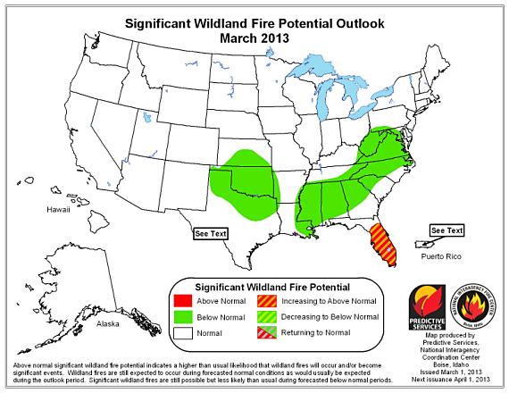
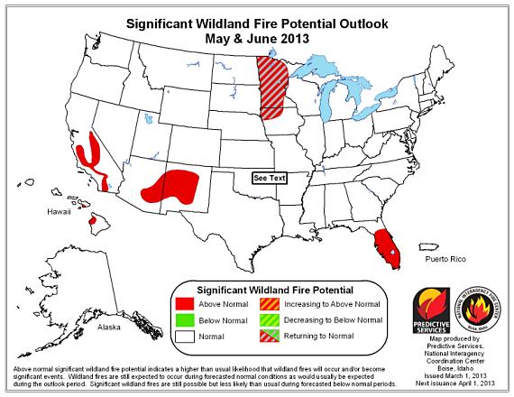
The Predictive Services section at the National Interagency Fire Center has issued their Wildland Fire Potential Outlook for March through June, 2013. If the predictions are accurate the south part of Florida could be busy during the period, and activity in Minnesota, the southwest, and in parts of California should pick up later.

Wildfire potential, March 2013

Wildfire potential, April 2013

Wildfire potential, May-June 2013

Below is an excerpt from the NIFC report:

****

“The March, April and May through June 2013 significant wildland fire potential forecasts included in this outlook represent the cumulative forecasts of the eleven Geographic Area Predictive Services Units and the National Predictive Services Unit.

March

  • February snow in the Plains and rain in the Southeast will keep fire potential normal to below normal, despite continuing drought conditions.
  • Very dry February for Florida will favor early start to season and increasing potential for significant fires.

April

  • Continuing rainfall deficits will keep significant fire potential above normal over most of Florida.
  • Despite February snows, soil moisture deficits in the Upper Midwest will increase significant fire potential as the snow cover dissipates.
  • Mid-Mississippi and Ohio Valleys will have below normal significant fire potential.

May and June

  • Dry fuels will drive above normal significant fire potential for central parts of the Southwest and mountains and foothills of southern California.
  • Above normal significant fire potential continues in Florida and on the lee side of Hawaii.
  • Significant fire potential will decrease to normal in the upper Midwest as greenup commences.”


Wildfire potential, February through May, 2013

The Predictive Services section at the National Interagency Fire Center has issued their Wildland Fire Potential Outlook for February through May, 2013. If the predictions are accurate wildfire activity in February and March should be normal or below normal, except for portions of Colorado, Kansas, Hawaii, and Florida.

February wildfire potential

March wildfire potential

April-May wildfire potential

More details from the NIFC report:

February

  • Precipitation deficits and long term extreme drought contribute to above normal significant wildland fire potential in the central Plains.
  • Periodic precipitation across the Mississippi and Ohio Valleys, central Gulf States and the mid-Atlantic will keep below normal significant wildland fire potential in much of the east.
  • Long term drought in Hawaii will keep above normal significant wildland fire potential on the Big Island.

March

  • The seasonal increase in fire across Florida will be amplified to above normal significant wildland fire potential by ongoing very dry conditions.
  • Late winter storm track will continue across the Ohio and Tennessee Valleys, keeping significant wildland fire potential below normal.
  • Drought continues in Hawaii.

April and May

  • Spring pre-greenup potential and long term drought keep parts of the Southeast, Oklahoma and Arkansas in above normal significant wildland fire potential.
  • Good winter precipitation and lingering spring precipitation keep the southern Appalachians and parts of mid-Atlantic below normal significant wildland fire potential.

Wildfire potential, January through April, 2013

The Predictive Services section at the National Interagency Fire Center has issued their National Wildland Fire Potential Outlook for January through April, 2013. If the predictions are accurate, wildfire activity should be normal or below normal, except for Hawaii in January.

Monthly Wildfire Outlook, January, 2013

Seasonal Wildfire Outlook, February - April, 2013

Significant Fire Potential

  • For January, above normal significant fire potential is expected on the western sides of the larger islands of Hawaii. By February through March, no areas of above normal significant potential are forecast in the United States.
  • Below normal significant fire potential is expected across much of the southeastern U.S. and the southern Ohio Valley for January and February, decreasing to an area from the mid-Mississippi Valley to the Appalachian Mountains by April.
  • Elsewhere, expect near normal significant fire potential to exist. In many areas of the western U.S., this indicates winter conditions that are generally considered out of fire season.

Wildfire potential, December 2012 through March 2013

The Predictive Services section at the National Interagency Fire Center has issued their National Wildland Fire Potential Outlook for December, 2012 through March, 2013:

Monthly wildfire outlook, December, 2012

Seasonal wildfire outlook, December 2012 - March 2013

Significant Fire Potential

  • For December above normal significant wildland fire potential only exists across a portion of the west central U.S. stretching from Nebraska and Wyoming south through Colorado, Kansas and Oklahoma into Texas and New Mexico. Small portions of the Hawaiian Islands also show above normal significant wildland fire potential. By the January through March timeframe no above normal significant fire potential is expected in the U.S.
  • Below normal significant fire potential is expected across much of the southeastern U.S. for the entire forecast period.
  • Elsewhere expect near normal significant fire potential to exist. In many areas of the western U.S. this indicates fall and winter conditions that are generally considered out of fire season.

Climate and Drought Conditions

  • El Niño/Southern Oscillation (ENSO): Equatorial Pacific sea surface temperatures continue to indicate a neutral ENSO pattern.
  • Drought: Most of the nation had less than 50 percent of normal precipitation for November with only parts of the northwestern U.S. receiving normal to above normal rain and snow. Severe to exceptional drought continued over most of the central and western U.S. with pockets in the Southeast.
  • Fuel Conditions: Generally fuel conditions across the areas of most concern this time of year are better than normal. However, a trend of continued dryness across much of the central U.S. especially into Colorado and New Mexico indicate the possibility of seeing an early onset of fire season in these areas, though that should be later in the outlook period.
  • Weather Outlook: Current climate projections by the Climate Prediction Center favor a continuing neutral pattern. For December, long range models indicated a high probability of above normal temperatures over much of the southern U.S. and northern Alaska while below temperatures settle over the northern Plains, the upper Midwest and southwestern Alaska. Precipitation projections indicate a high likelihood of below median precipitation for the mid-Mississippi and Ohio Valleys. Southeastern Alaska will likely be drier than normal.

For January through March, projections show higher probabilities for above normal temperatures across northern Alaska, most of the Southwest, the Great Basin, the central and southern Rockies, the central and southern Plains, and the lower Mississippi Valley. Below normal temperatures are probable over the far northern Plains and southern Alaska. Precipitation will be above median over the Ohio and mid-Mississippi Valleys and below median across California and the Southwest.