Wildfire potential increases in California and the Northwest

(Originally published at 11:55 a.m. MDT July 2, 2018)

On July 1 the Predictive Services section at the National Interagency Fire Center issued their Wildland Fire Potential Outlook for July through October. The data represents the cumulative forecasts of the ten Geographic Area Predictive Services Units and the National Predictive Services Unit.

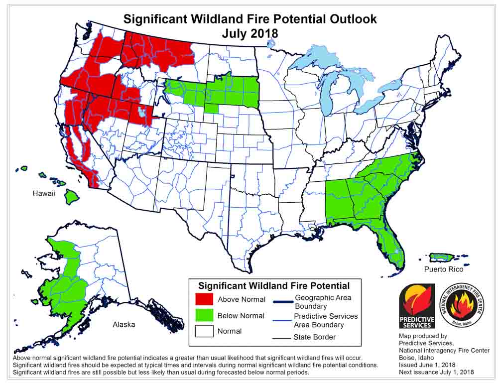
If their analysis is correct, in July the areas with the highest potential will move from the Southwest to Washington, Oregon, Idaho, Utah, California, and northern Nevada.

Below are:

  • The highlights of the NIFC narrative report for the next several months;
  • NIFC’s monthly graphical outlooks;
  • NOAA’s three-month temperature and precipitation forecasts; and,
  • Drought Monitor.

“Abnormally dry conditions along the West Coast allowed for a northward expansion of drought into western Oregon and Washington in June. Some improvement was noted across the southern Great Plains while drought emergence was observed across the Lower Mississippi River Valley. Preexisting drought conditions and continued drier than average conditions across the Southwest allowed for a normal progression of the fire season across the Four Corners Region until mid-month when the remnants of Hurricane Bud moved north from Mexico and produced widespread wetting rainfall that reduced the elevated large fire potential in that area. While rainfall amounts that were greater than 200% of average were received across Arizona, New Mexico, and portions of southwestern Colorado, the Great Basin and California remained very dry receiving less than 10% of average precipitation. Temperatures across the West were near average for the month from the Pacific Coast east to the Continental Divide. East of the Divide, temperatures were near average.

“The southwestern monsoon is expected to arrive in early July and should reduce fire activity across the Southwest. A normal refocusing of fire activity north into the Great Basin and west into California is expected. The existence of a continuous grass from this year along with carryover of fine fuels from 2017 should lead to Above Normal Significant Large Fire Potential in these areas. By late July, fire activity is expected to increase across Oregon and Washington. Entry into the Western Fire Season will be delayed slightly across most of the Northern Rockies due to the persistent wet systems that impacted the region through… However, precipitation data shows an area of below average precipitation for June across extreme northwestern Montana and northern Idaho. As a result, both areas could experience an early entry into the fire. In Alaska, the fire season will gradually come to an end in July as precipitation events become more frequent.

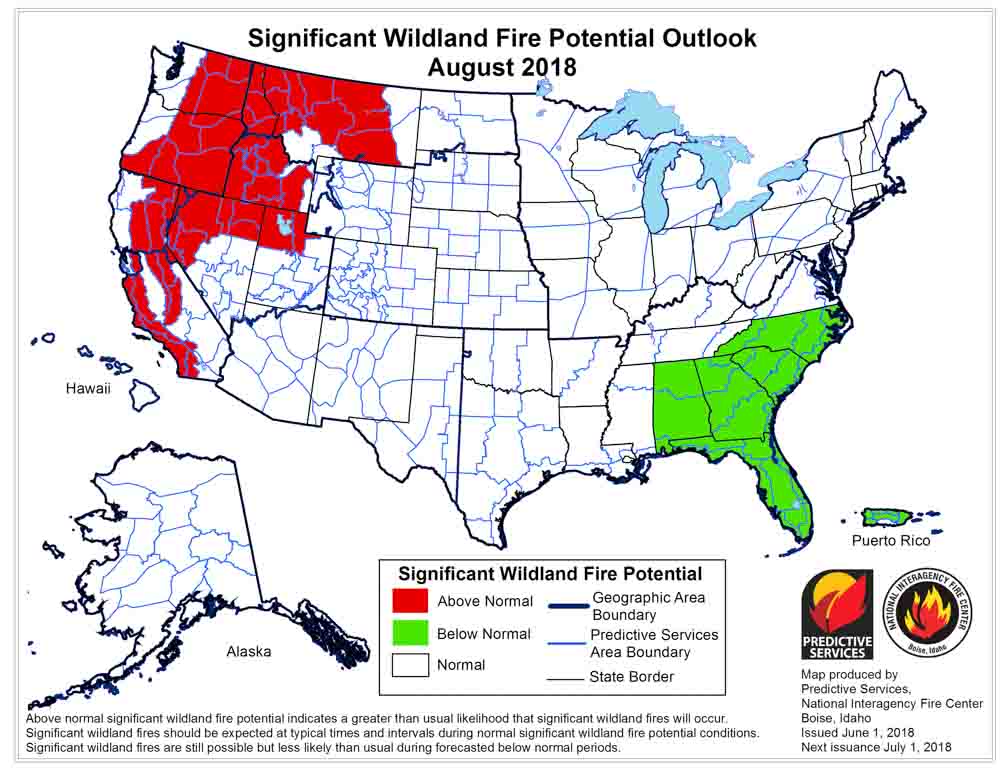
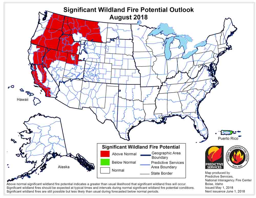
“August is the peak of the Western fire season. Seasonal transitions focus the fire activity over the northwestern quarter of the country, though California also continues to experience significant activity. With significant carryover of fine fuels from last year and an average grass crop growth this year, elevated fire potential is expected August through early September in this region from California and the Central Great Basin north to the Canadian Border. Higher elevations in the mountains may also see elevated fire potential as well should warmer and drier than average conditions develop as expected.

Continue reading “Wildfire potential increases in California and the Northwest”

Wildfire potential, June through September

(Originally published at 1:27 p.m. MDT June 1, 2018)

On June 1 the Predictive Services section at the National Interagency Fire Center issued their Wildland Fire Potential Outlook for June through September. The data represents the cumulative forecasts of the ten Geographic Area Predictive Services Units and the National Predictive Services Unit.

If their analysis is correct, in July the areas with the highest potential will move from the Southwest to Washington, Oregon, Idaho, Western Montana, California, and northern Nevada.

Below are:

  • The highlights of the NIFC narrative report for the next several months;
  • NIFC’s monthly graphical outlooks;
  • NOAA’s three-month temperature and precipitation forecasts; and,
  • Drought Monitor.

“Preexisting drought conditions along with continued drier than average conditions across the Southwest allowed for a normal progression of the western fire season across the Four Corners Region and West Texas in May. By month’s end, the focus of activity began to shift westward into Arizona and Southern California. Northern Minnesota and North Dakota experienced above average fire activity as drought conditions took hold. Alaska experienced a slight uptick in fire activity as fuels began to dry. However, the occurrence of periodic precipitation events allowed for a gradual entry into its fire season. Concerning precipitation trends were emerging across California, Oregon, and Washington as most locations received 50 percent of average precipitation or less during May. In the East, many locations across the Southeast, including Florida, received more than 300 percent of average precipitation during the month.

“The combination of deepening drought and the carryover of fine fuels from 2017 is expected to lead to a continuance of Above Normal Significant Large Fire Potential across western portions of the Four Corners Region and Southern California during June. Late June through early July are the peak of fire season across the Southwest and Alaska. During July, activity begins to spread west and north with the drying and curing of the fuels. The Southwestern monsoon begins and reduces fire activity across the Southwest while wetter patterns across Alaska become better established through the month thus drawing its season to a close. These climatologically normal transitions are expected to occur this year as the Western fire season begins to expand and intensify northward.

“Areas of heightened concern will be locations shown on the maps to the left that have both a significant carryover of fine fuels from 2017 and a normal growth of fine fuels this year. In addition, winter snowpack in the higher elevations along the West Coast was well below average, except in Washington State where it was near normal. However, a drier than average spring may offset the average snowpack and melting rates. This should allow for fuels in the mountains to become critically dry by mid-late July. Further inland, the Northern Rockies experienced a very snowy winter, and snowpack is melting at an average rate. However, a wet spring has promoted the growth of a very healthy, continuous crop of fine fuels that should become receptive to fire in the lower and middle elevations by mid to late July.

“August is the peak of the Western fire season. Seasonal transitions focus the fire activity over the northwestern quarter of the country, though California also continues to experience significant activity. With significant carryover of fine fuels from last year and average grass crop growth this year, elevated fire potential is expected through August and early September across many of the lower and middle elevations from the central Great Basin and California northward to the Canadian border. Higher elevations in the mountains may also see elevated fire potential as well should warmer and drier than average conditions develop as expected.

“Typically, a weather event occurs in mid-September that brings moisture to regions experiencing significant fire activity which allows for the western fire season to begin to decrease in activity. Anticipated trends in long range weather data suggests this to be the case this September as ENSO Neutral conditions begin to shift toward El Niño for the fall and winter months.”


wildfire potential outlook map July

wildfire potential outlook map August

Continue reading “Wildfire potential, June through September”

Wildfire potential, May through August

(Originally published at 12:03 p.m. MDT May 1, 2018)

On May 1 the Predictive Services section at the National Interagency Fire Center issued their Wildland Fire Potential Outlook for May through August. The data represents the cumulative forecasts of the ten Geographic Area Predictive Services Units and the National Predictive Services Unit.

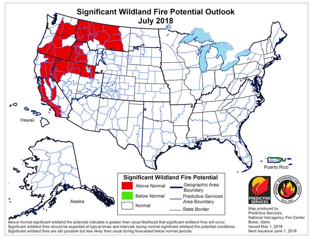
If their analysis is correct, in July and August California, the northwest, and the northern Rockies will experience above normal wildfire activity.

Below are:

  • The highlights of the NIFC narrative report for the next several months;
  • NIFC’s monthly graphical outlooks;
  • NOAA’s three-month temperature and precipitation forecasts; and,
  • Drought Monitor.

“The significant wildland fire potential forecasts included in this outlook represent the cumulative forecasts of the ten Geographic Area Predictive Services units and the National Predictive Services unit.

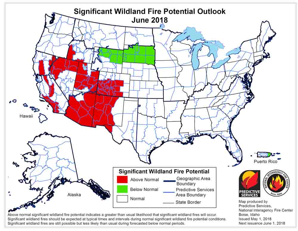
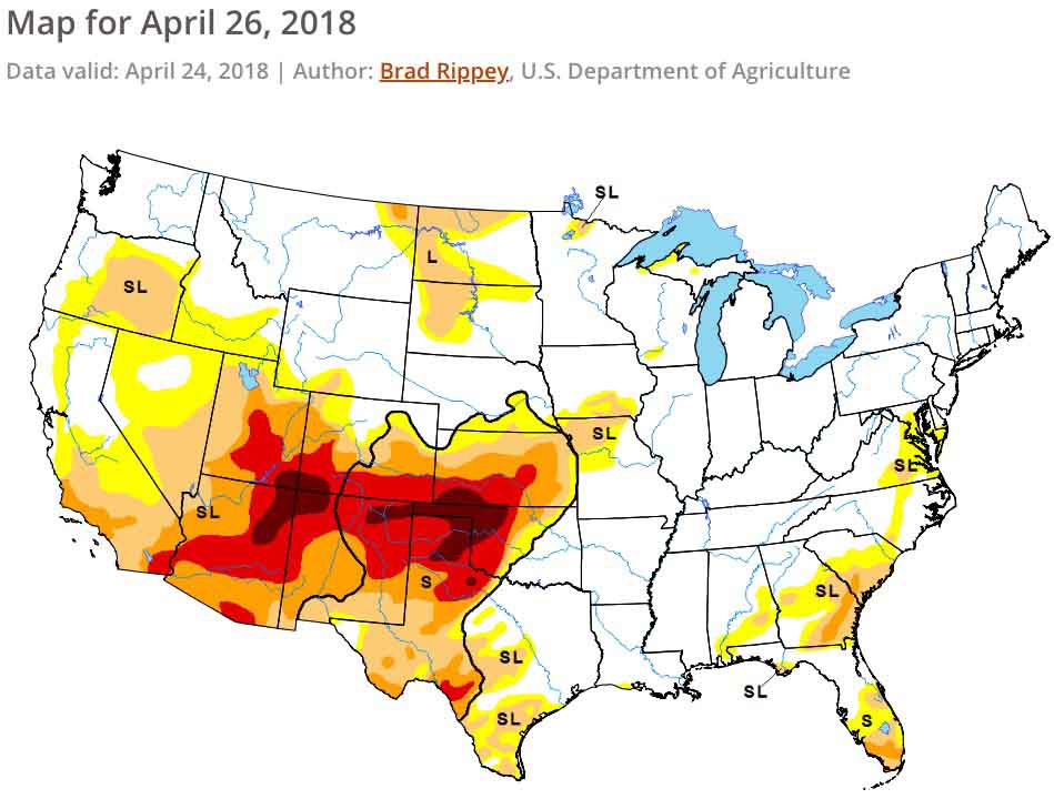
“Preexisting drought conditions along with several wind events allowed for fire activity across the southern Great Plains and New Mexico to increase in April. By month’s end, activity was beginning to spread westward into Arizona and southern California. Entering May, a normal progression of fire activity is being observed as the Great Plains begins to receive its spring rainfall while the Southwest continues to be dry. What is atypical is the drought severity that is in place across the Four Corners Region and now southern California. The drought coupled with the carryover of an above average fine fuel growth from last year is expected to lead to Above Normal Significant Wildland Fire Potential in May and June across portions of the Southwest, Great Basin, and southern California. In the East, the elevated potential across Florida and portions of Georgia will return to Normal potential as summertime convective patterns ensue.

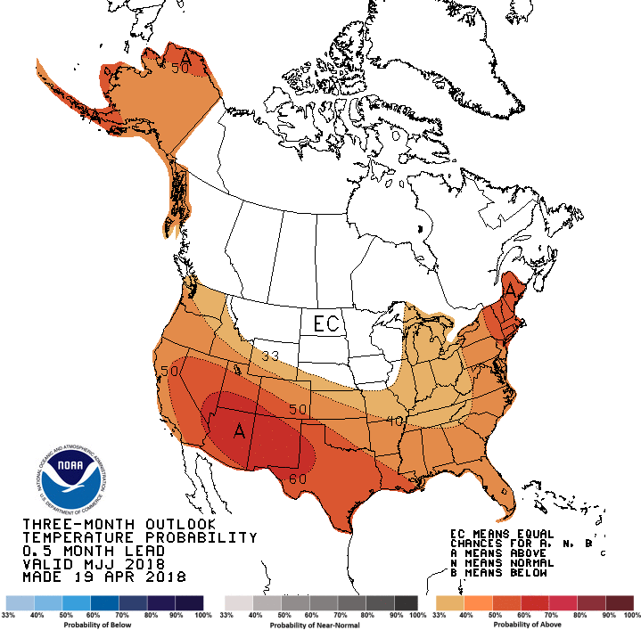
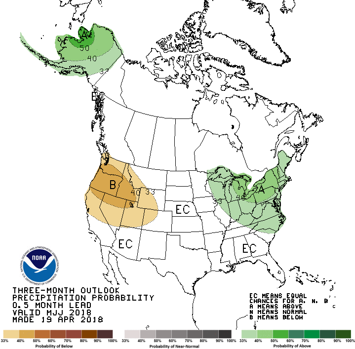
“The peak of the fire season in the Southwest is expected to occur by late June, just before the onset of the annual monsoon season which should gradually bring their season to a close. Data suggests that the monsoon’s arrival should occur by early July. The projected focus of the monsoon’s early surges will be across New Mexico and Colorado but will refocus westward as July progresses. A normal transition of fire season activity west and north is expected through July as warmer and drier than average conditions develop across the western states. Of concern is the preexisting grass crop from 2017 and the new growth which will cure by July across California, the Great Basin, and Oregon. Higher, timbered elevations in these areas will become a concern by July as the past winter’s below average snowpack melts allowing for the high elevation fuels to become dry enough to support fire activity.

“In August, seasonal transitions focus the fire activity over the northwestern quarter of the country, though central and southern California also continue to experience significant activity. With significant carryover of fine fuels from last year and average grass crop growth this year, elevated fire potential will continue into August across many of the lower and middle elevations from the central Great Basin and California northward to Canada. Higher elevations in the Cascades, Northern Sierras, and possibly the Northern Rockies may also see elevated fire potential as well should warmer and drier than average conditions develop as expected.

“In Alaska, Normal Significant Wildland Fire Potential is expected as the state experiences a typical transition into fire season. Conditions across the state have been generally wetter than average while temperatures have been warmer than average. Since this pattern is expected to continue through the core of the Alaskan fire season, the potential for Above Normal Significant Wildland Fire Activity is low.”

wildfire potential June

wildfire potential July

wildfire potential August

temperature 0utlook

Precipitation outlook

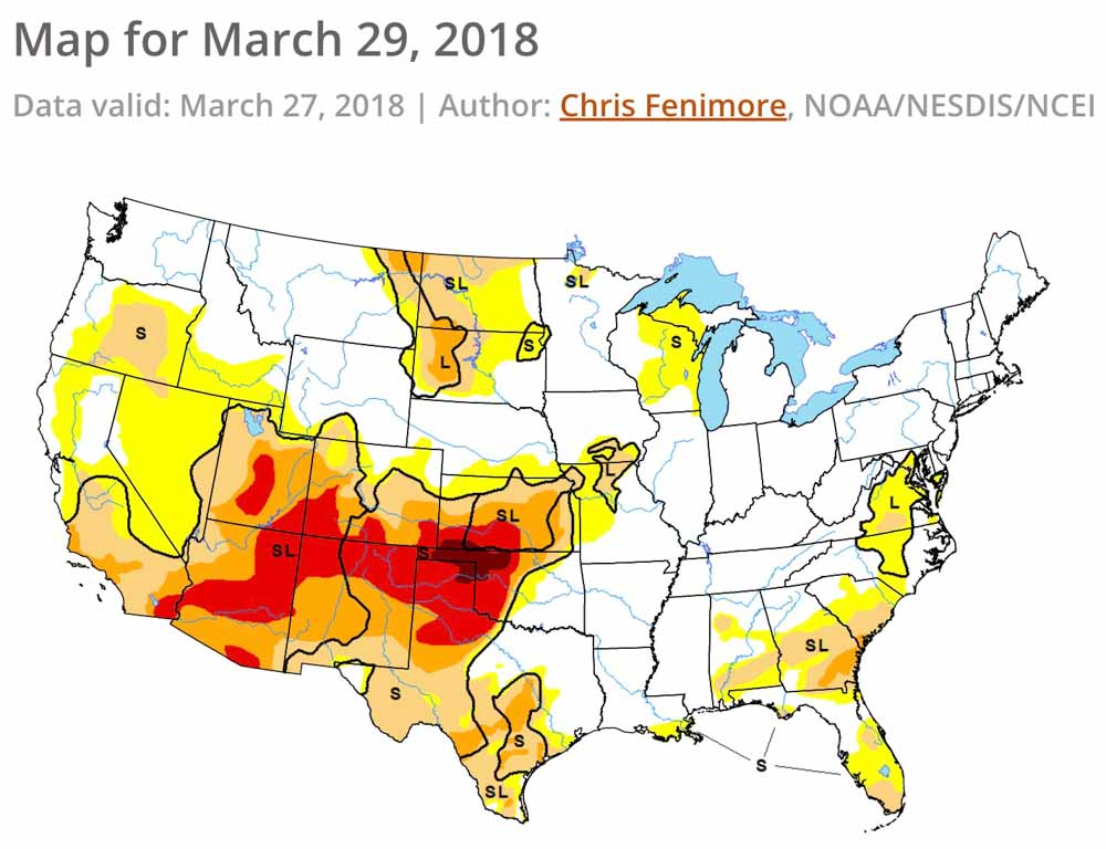
Drought Monitor
Drought Monitor

Wildfire potential, April through July

By July Montana, California, Colorado, and the states in the Northwest could see above normal wildfire activity

(Originally published at 8:55 p.m. MT April 1, 2018)

On April 1 the Predictive Services section at the National Interagency Fire Center issued their Wildland Fire Potential Outlook for April through July. The data represents the cumulative forecasts of the ten Geographic Area Predictive Services Units and the National Predictive Services Unit.

Below are:

  • The highlights of the NIFC narrative report for the next several months;
  • NIFC’s monthly graphical outlooks;
  • NOAA’s three-month temperature and precipitation forecasts; and
  • Drought Monitor.

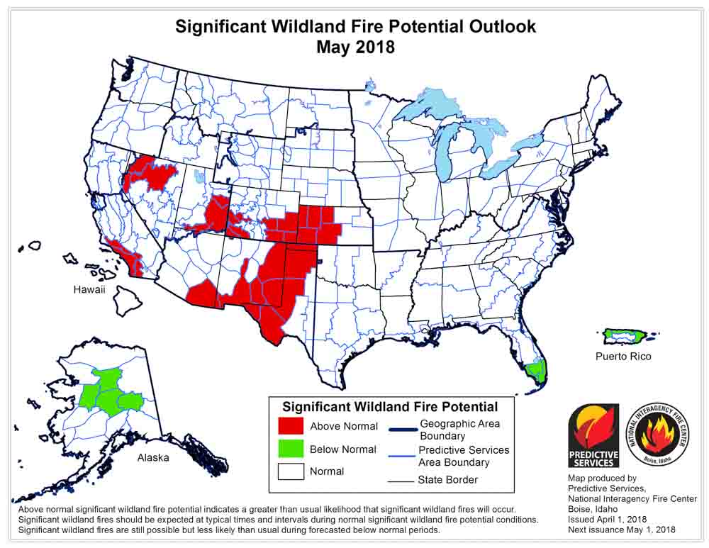
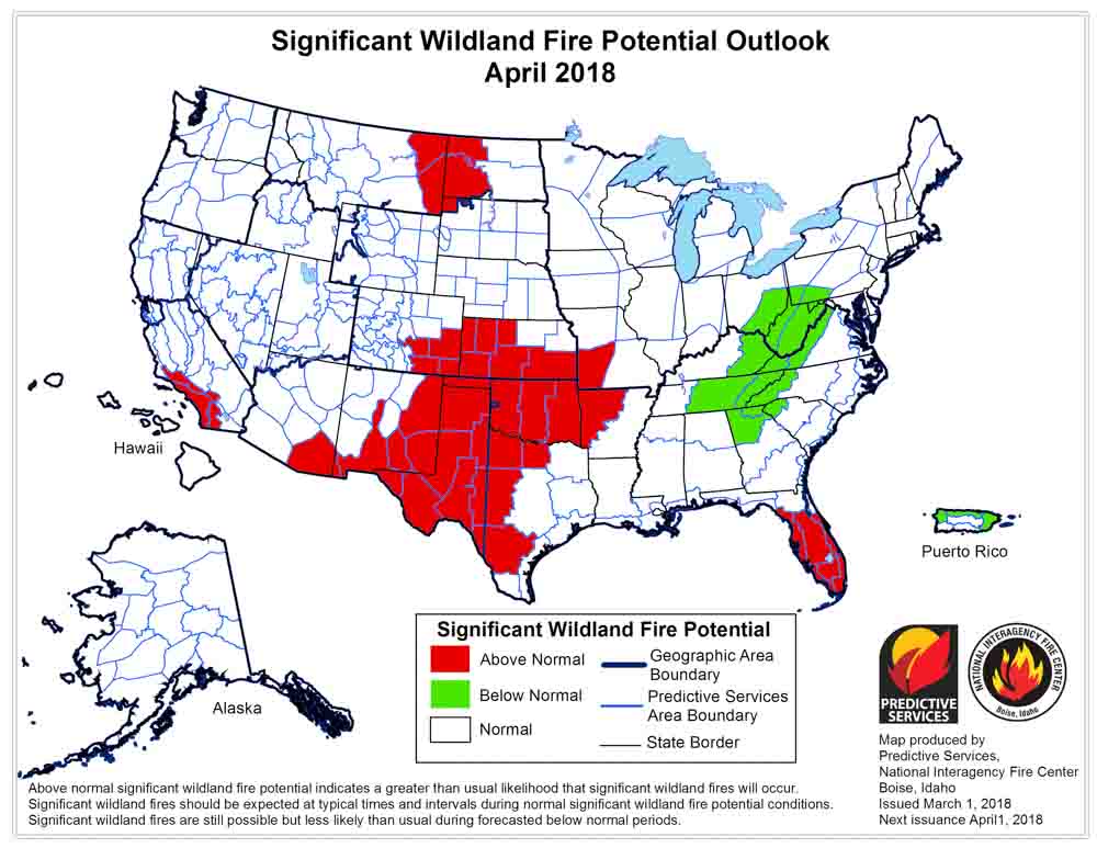
“Wildfire activity will increase across portions of the nation in April. The central and southern Great Plains continue to experience significant wildland fire activity. While the activity observed is Above Normal, overall trends follow a traditional seasonal progression which keeps the fire potential elevated across these areas in early April but begins a westward shift further into the Southwest by month’s end. Periods of concern will be wind events coupled with low humidities that impact fire activity. Other areas of concern are the Florida Peninsula, eastern Georgia and South Carolina where drought conditions linger. Elevated potential exists across coastal portions of Southern California where drought continues and across portions of eastern Montana where very dry residual soil conditions exist. Pregreenup fire activity could elevate during westerly flow wind events.

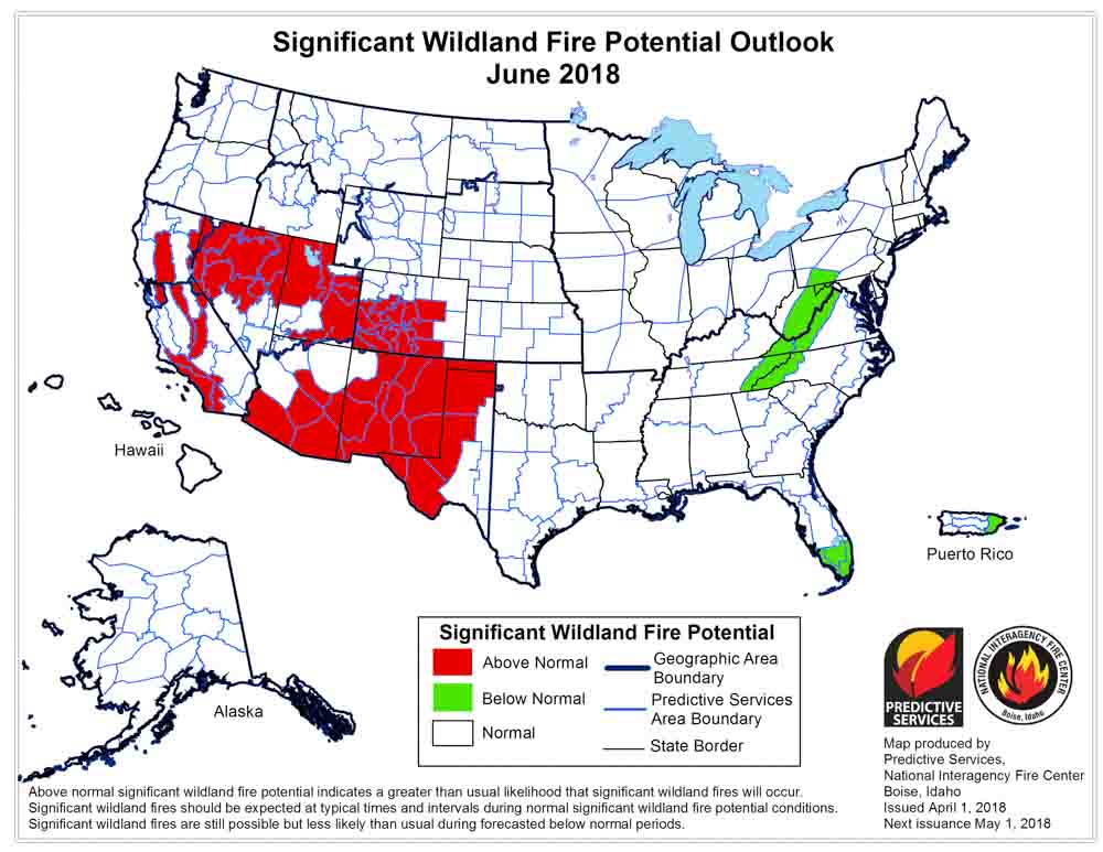
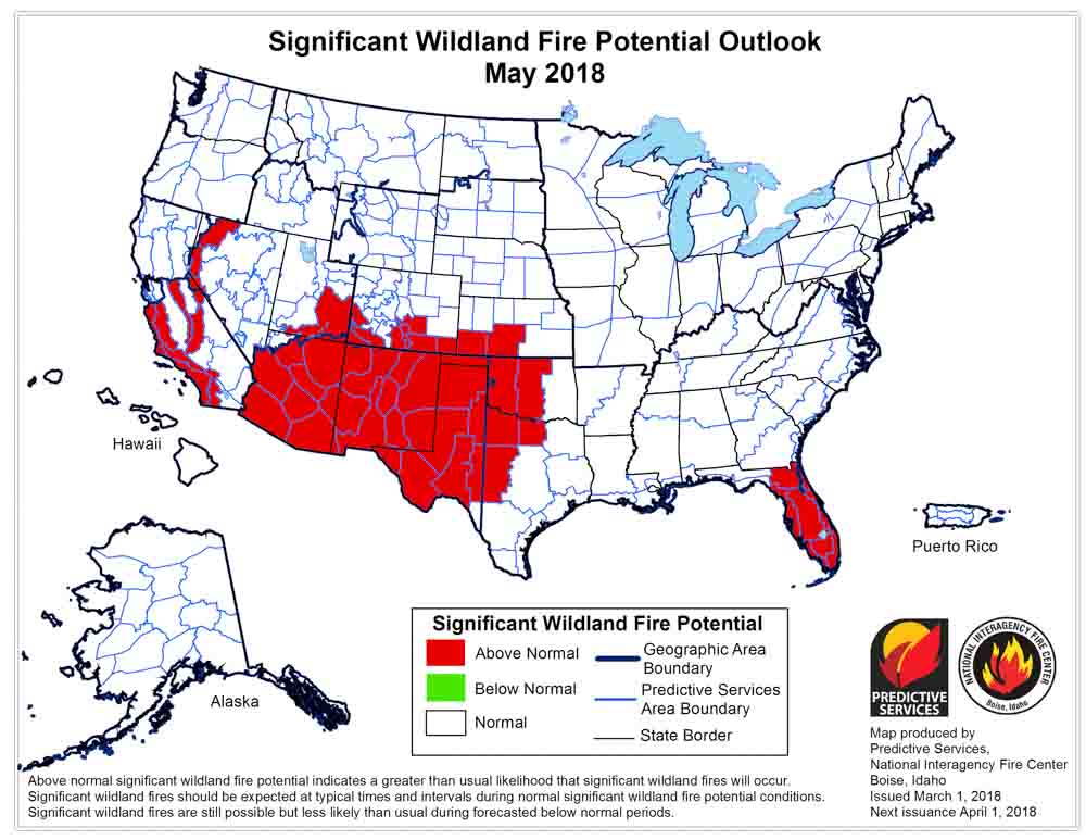
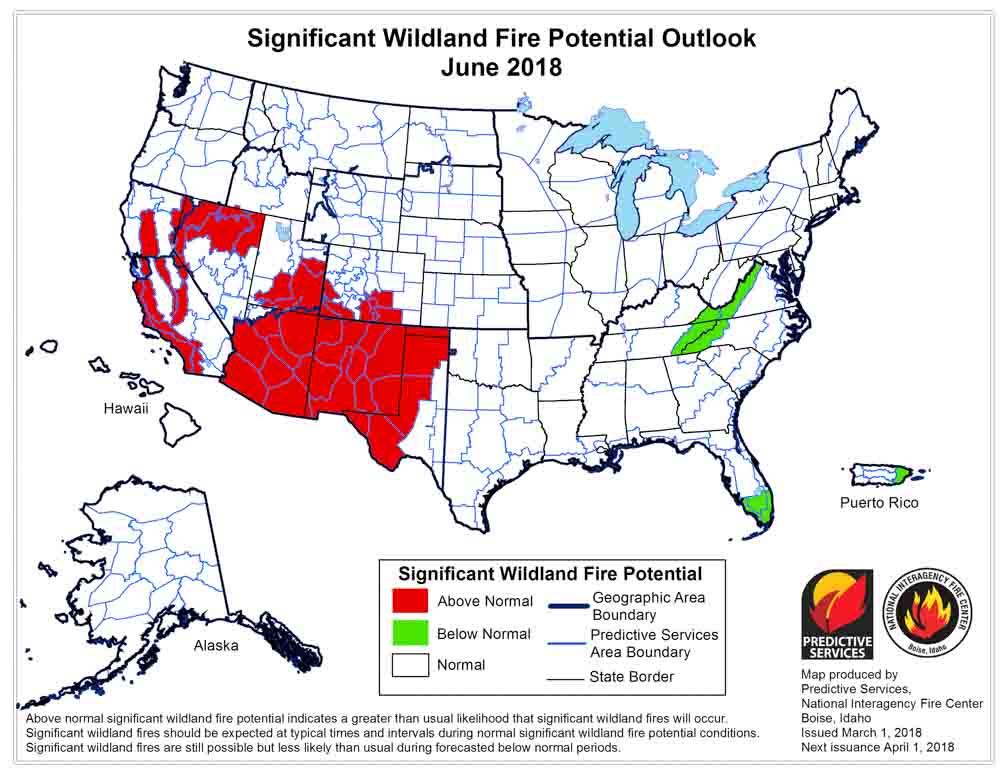
“In May and June, the worsening drought conditions across the Southwest will lead to a continuance and expansion of the areas encompassed by an Above Normal potential for large fire activity. Fuels across the southern Great Basin and additional portions of California will become receptive as the vegetation dries and cures. Above Normal large fire potential across the Florida Peninsula in May will diminish by June as Sea/Land breeze convective activity begins to develop. Preexisting conditions across Alaska suggests a Normal potential for fire activity across the state’s interior.

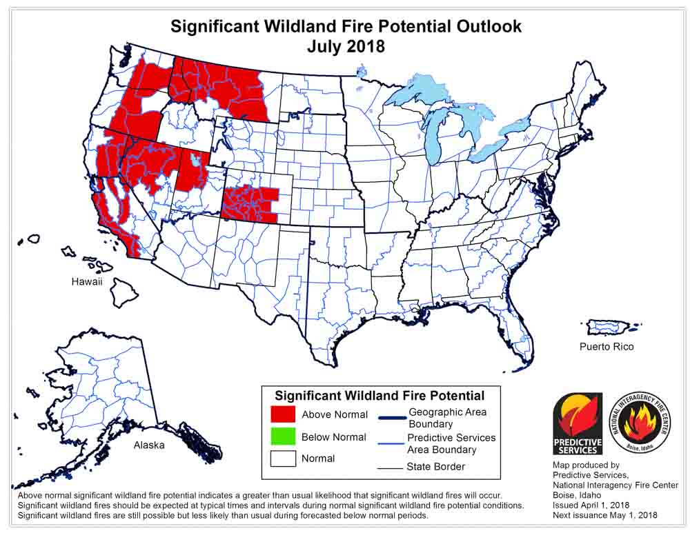
“July marks the beginning of the core of the Western Fire Season. Concerns exist across the Interior West and California where a carryover of last year’s record grass crop coupled with the growth of an average grass crop this year will cure and become receptive. With a below average mountain snowpack observed from Oregon south to the border, an elevated potential may develop in the higher elevations by month’s end. Indicators suggest an early arrival of the Southwestern Monsoon. This should end the Southwestern season; however, the abundant convective activity will inevitably spread northward into the Great Basin and points north.”
wildfire potential May 2018 wildfire potential June 2018 wildfire potential July 2018

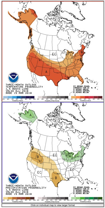
weather 90 day outlook

Drought Monitor
Drought Monitor

Wildfire potential, March through June

Posted on Categories UncategorizedTags ,

In Southern California, the Southern Plains, and portions of the Southwest, wildfire potential should remain above normal through June.

Above: wildfire potential for March, 2018, issued March 1, 2018.

(Originally published at 5:10 p.m. MT March 1, 2018)

On March 1 the Predictive Services section at the National Interagency Fire Center issued their Wildland Fire Potential Outlook for March through June. The data represents the cumulative forecasts of the ten Geographic Area Predictive Services Units and the National Predictive Services Unit.

If the prediction is accurate, the wildfire potential in Southern California, the Southern Plains, and portions of the Southwest will remain above normal for the entire four-month period.

Below are:

  • The highlights of the NIFC narrative report for the next several months;
  • NIFC’s monthly graphical outlooks;
  • NOAA’s three-month temperature and precipitation forecasts; and
  • Drought Monitor.

“Wildfire activity is likely to increase in March in a manner typical to most years beginning in the central through southern Great Plains and the Southwest where preexisting drought conditions and fuel loadings have promoted an environment favorable for Above Normal significant wildland fire potential entering spring. While some improvement is expected across East Texas and Arkansas, areas to the west will likely see a continuance or an intensification of the Severe Drought conditions. Periods of special concern will be highlighted by passing weather systems that create periodic strong, westerly, downsloping winds. During such events, ignitions will be able to quickly become significant fires. Elevated large fire potential is also expected to continue across coastal portions of Southern California where preexisting dry conditions have left fuels in a very dry state.

“As the Western Fire Season continues to increase in activity across the Southwest in April, conditions across the central and southern Great Plains will gradually improve as greenup takes hold. Concerns across Southern California will remain as dry conditions will have led to a muted green up across the southern half of the state. Conditions in Alaska entering spring suggest a normal seasonal transition. While some areas of abnormally dry conditions exist across portions of the southwestern interior, large fire potential is expected to remain near normal entering May.

“The fire season activity across the Southwest will peak in May and June. Above Normal significant large fire potential is expected across the southern tier of the region during this period as drought conditions intensify under the dry, building heat. The same conditions will continue to promote Above Normal potential as well across Southern California. There is some indication that the Southwestern Monsoon may produce some initial surges in activity in late June. This could begin to slow activity across both regions while initiating the seasonal shift northward into the Great Basin. In Alaska, above average temperatures and near average precipitation across the state’s interior is expected to lead to Normal significant large fire potential for the core fire season months of May and June.”

April wildfire outlook weather

May wildfire outlook weather

June wildfire outlook weather

APRIL-JUNE 2018 WEATHER

Drought Monitor
Drought Monitor

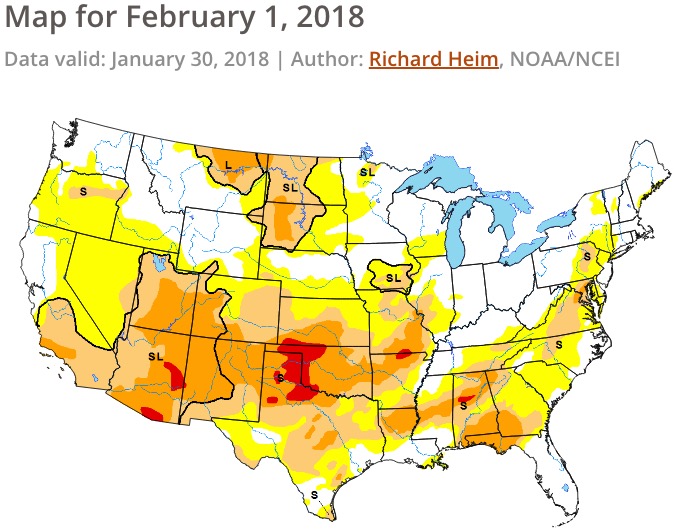
Wildfire potential, February through May

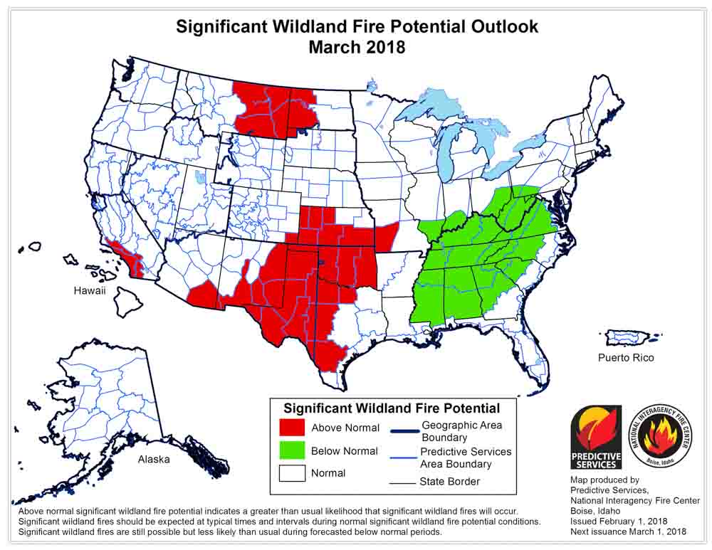
Above: wildfire potential for February, 2018, issued February 1, 2018.

(Originally published at 1:41 p.m. MDT February 1, 2018)

On February 1 the Predictive Services section at the National Interagency Fire Center issued their Wildland Fire Potential Outlook for February through May. The data represents the cumulative forecasts of the ten Geographic Area Predictive Services Units and the National Predictive Services Unit.

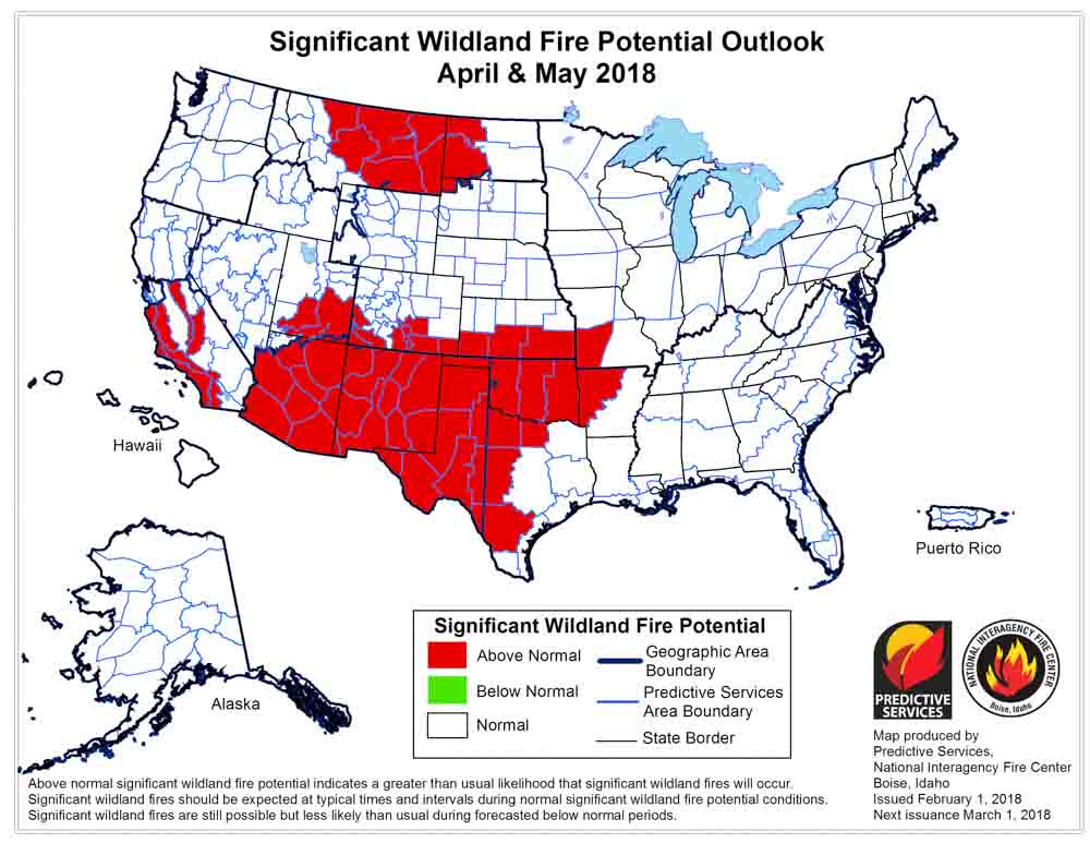
If the prediction is accurate, the wildfire potential in Southern California and the Southern Plains will remain above normal for the entire four-month period and will increase in the Southwest and Northwestern Great Plains in Montana and North Dakota. The Eastern U.S. should expect normal or below normal potential.

Below are:

  • The highlights of the NIFC narrative report for the next several months;
  • NIFC’s monthly graphical outlooks;
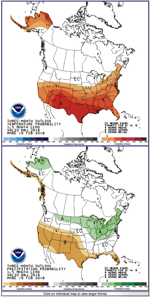
  • NOAA’s three-month temperature and precipitation forecasts; and
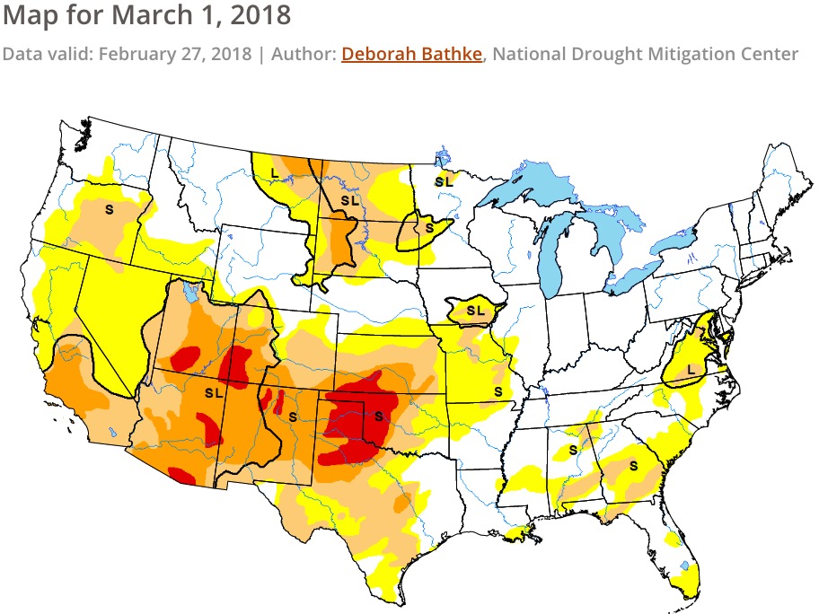
  • Drought Monitor.

“The significant wildland fire potential forecasts included in this outlook represent the cumulative forecasts of the ten Geographic Area Predictive Services units and the National Predictive Services unit.

“Wildfire activity is likely to begin to increase in February as would be seasonally expected. During the early portions of the year it is typical for significant fires to begin to occur across the southern tier of the U.S. Currently it appears the highest likelihood for above normal significant wildland fire potential will be in place across portion of the southern plains and Florida and Georgia. Across the southern plains the last years precipitation totals have brought about a somewhat robust fine fuel crop, which will provide an elevated baseline of fire activity. When this elevated fuel condition is exacerbated by a period of dry and windy conditions it will provide opportunities for any ignitions to become significant fires.

“These incidents will be difficult to predict, but extra attention should be paid to this area when dry and windy conditions are forecasted. In Florida and Georgia the significant drought that led to amplified fire activity in the fall across the south has not improved. Moisture deficits in these fuel types are significant because they not only make ignition significantly more likely but they also make fires much more difficult to fight. Both conditions make the need for fire suppression resources higher. Both of these significant areas of above normal potential are likely continue through March and probably return to normal in April or May.

“At the end of the Outlook period significant fire potential across portions of Alaska will being to increase. This is also generally seasonally anticipated, however, the potential for above normal significant fire activity in the south central portion of the state is likely. Drought conditions indicate that some unusual dryness will be in place in this area as fire season begins. This will likely lead to earlier than usual ignitions and the potential for worse than usual fires. In the shorter term Hawaii is likely to see some elevated activity thanks to some unusual dryness, but this condition is expected to be short lived.

“Additionally, fire activity is expected to be below normal across western portions of Tennessee and Kentucky throughout the Outlook period.”


wildfire potential March

wildfire potential April May

3-month temperature precipitation outlook

drought monitor
Drought Monitor