Everglades National Park to burn 31,000 acres

Everglades National Park, Coastal Prairie prescribed fire, May, 2011. NPS photo by Jennifer Brown
File photo. Everglades National Park, Coastal Prairie prescribed fire, May, 2011. NPS photo by Jennifer Brown

Today and tomorrow Everglades National Park in south Florida expects to burn 31,000 acres in one project. The prescribed fire will be part of their continuing program control exotic species and reduce fuel in the area south of U.S. 41, east of the Shark Valley park entrance.

Equipment to be used on the “River of Grass Northeast” project will include three engines, two helicopters, a single-engine air tanker, and one airboat.

At 2:00 p.m. ET we talked with the park’s information officer, Linda Friar, who said the prescribed fire started at 11:00 a.m. ET and so far was going well. We will post an update to this article later today or tomorrow as the burn progresses.

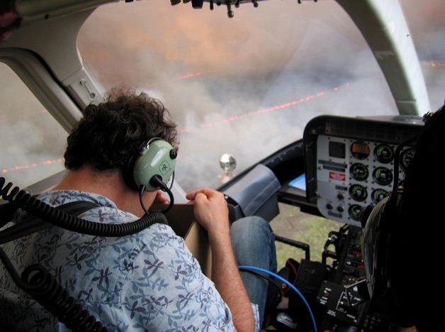
From the photo below, it appears that personnel flying over the Everglades National Park’s Coastal Prairie Prescribed Fire in May, 2011 were a little casual in their choice of attire. In most government-operated helicopters working on a fire, a helmet and fire resistant clothing would be required. More National Park Service photos from that prescribed fire are on the park’s flickr page. UPDATE:  As you can see in the comments below this article, we heard from Rick Anderson, the Fire Management Officer for Everglades National Park, who said:

That photo is Huw Cordry of Wild Horizons LTD, you may know his work from the “Planet Earth” series filming a fire on our coastal prairies. This is not a NPS mission and the ship is private.. Thanks for your comments on aviation safety. Everglades Fire and Aviation flies around 500 missions a year with an excellent safety record. We seek safety in everything we do.
Everglades NP prescribed fire
File photo. Everglades National Park, Coastal Prairie prescribed fire, May, 2011. NPS photo by Jennifer Brown

Prescribed fire in Western Australia escapes, burns dozens of homes

A prescribed fire in Leeuwin-Naturaliste National Park in Western Australia escaped on November 23 and has destroyed or heavily damaged 19 to 30 homes in the Prevelly area. Pushed by strong winds, the fire has burned at least 4,900 acres.

Fifty-five people that had refused to be evacuated later had to take refuge from the fire on a Prevelly beach. They were rescued by jet ski and ferried to a waiting search and rescue boat offshore. From there they were taken to nearby Gracetown and then bused to an emergency welfare center in Margaret River.

City employee in Massachusetts burned during prescribed fire

For at least the last 42 years, the Stoughton, Massachusetts (map) Department of Public Works had burned the brush at Mead’s Meadow to prepare the area around the pond for ice skating season. There had been no major problems until Monday, when an unexpected wind shift pushed the fire toward DPW employee Steve Lewandowski. He tried to run, but he got stuck in mud. John Batchelder, Superintendent of the DPW, said Lewandowski was able to bend over and get his face in the mud and water while the flames burned across his body.

Lewandowski was admitted to the Burn Unit at Massachusetts General Hospital Monday evening. Later the hospital listed him in good condition. His girlfriend said he has burns on his neck, and back, and his face is reddened.

No one from the Fire Department was present during the prescribed fire. A local resident called 911 when she heard a man at the project site screaming repeatedly, and saw that the flames were higher than she usually saw when the DPW burned the meadow. Police and fire units responded and helped Lewandowski walk out of the burn area to a ground ambulance.

According to an article at the Taunton Gazette, Batchelder said the DPW employees responsible for starting and controlling the fire have no training to do so. Fire Chief Mark Dolloff said he will investigate the incident.

Smoke from Black Hills prescribed fire photographed by satellite

Lemming Prescribed Fire 1745 9-30-2011
Smoke from the Lemming prescribed fire can be seen on the right side of this satellite photo, which was taken at 5:45 p.m. MT, 9-30-2011

Judging by the smoke I can see east of Hot Springs, South Dakota, and by looking at the satellite photo above, the Lemmings prescribed fire on the Mystic District of the Black Hills National Forest appears to be burning quite well. It can be seen on the right side of the photo, in the southwest corner of South Dakota.

HERE is a link to a Google map showing the exact location. On that map, you can see that the prescribed fire is just north of the Jasper fire (shown as brown or red) which burned 83,000 acres in the Black Hills National Forest and around Jewel Cave National Monument August 24, 2000. Prescribed fires conducted in Jewel Cave NM prior to 2000 caused the crowning Jasper fire to drop to the ground and burn slowly through the Monument. The only structure that burned at Jewel Cave was an old unused outhouse that firefighters forgot about. A creeping fire burned up to it and consumed it during mopup activities the day after the fire burned through the park. But management was probably happy to be rid of it since it may have been historic, and would have had to be protected and maintained for eons.

The USFS describes the Lemming prescribed fire:

The Mystic Ranger District will begin the Lemming prescribed burn, weather permitting, on September 30th and continue through the weekend. Crews aim to burn 1777 acres in the Lemming Draw area, 11 miles west of Hill City. Smoke will be visible from Hill City and many other locations, and can linger for several days after ignition has been completed. Forest Service crews will secure, patrol, and monitor control lines for as long as needed. Lemming Draw lies near the northern end of the Jasper Fire area; substantial surface fuels are present in the area as a result of the 2000 wildfire. The prescribed burn will aim to reduce the surface fuels by burning them under moderate conditions protecting existing pine seedlings and saplings, soils, and water quality.

American Elk prescribed fire, six months later

When Wind Cave National Park in southwest South Dakota conducted their American Elk prescribed fire in October, 2010 I dropped by to take some photos on the first and second days of the two-day project. On May 8, 2011 I visited the site again to see what it looked like six months later and took some additional photos. In two cases I attempted to duplicate photos taken earlier.

American Elk prescribed fire, Oct. 21, 2010
American Elk prescribed fire, May 8, 2011
American Elk prescribed fire, Oct. 21, 2010


American Elk prescribed fire, May 8, 2011.
American Elk prescribed fire, May 8, 2011. The area to the left of the red line was part of the burn. Bison are enjoying the new regrowth.

Continue reading “American Elk prescribed fire, six months later”