Strong winds and low humidity to begin Sunday night
6:35 p.m. PDT Oct. 10, 2021
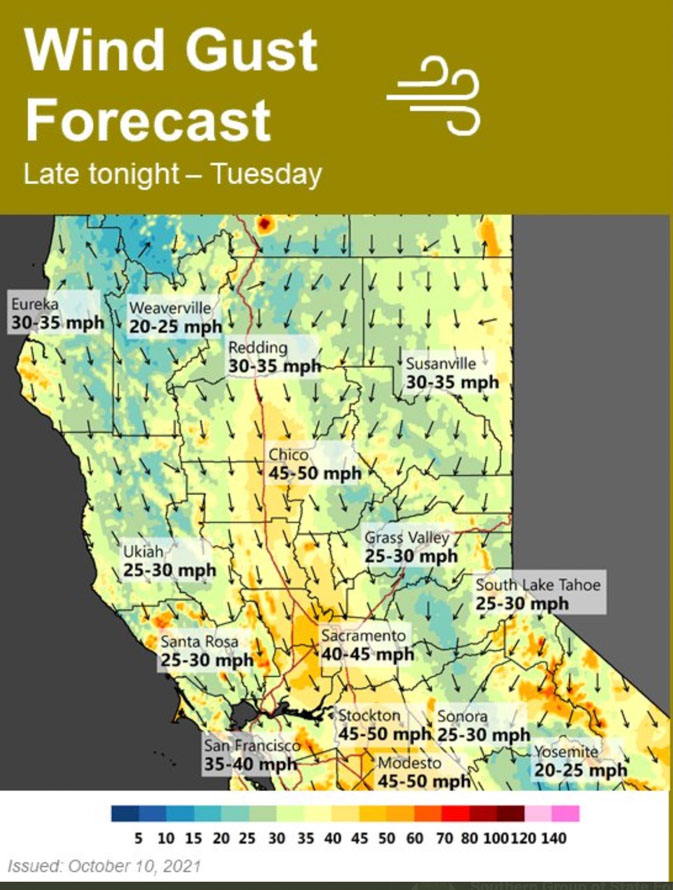
Forecast for wind gusts, Sunday night through Tuesday, Northern California. NWS Sacramento, at 1 p.m. PDT Oct. 10, 2021.
Much of California between Los Angeles and Redding will be under elevated fire danger or Red Flag Warnings Monday and Tuesday. Strong north winds are predicted to begin Sunday night, peak on Monday, and last through Tuesday. Temperatures will not be as high as is seen in typical Santa Ana wind events, but they will be higher than normal and relative humidities will be low.
In the North Bay, for example, winds will develop late Sunday evening from the north at 30 to 40 mph, and will be locally higher near favored gaps, canyons, and in the Valley. Minimum humidity will drop to 10 to 25 percent Monday and slightly lower on Tuesday. Overnight recovery will be 25 to 50 percent.
Any fires that develop could spread rapidly.
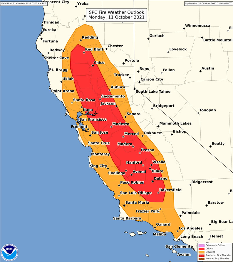
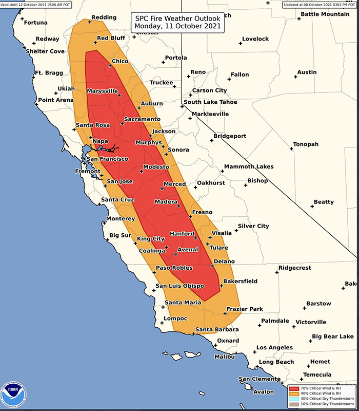
Storm Prediction Center outlook for critical fire weather, Monday, Oct. 11, 2021. Updated at 11:46 a.m. PDT Oct. 10, 2021.
Strong winds and low humidity expected Monday and Tuesday in portions of California
Red Flag Warnings and Fire Weather Watches at 10 a.m. PDT October 9, 2021. NWS/Google.
Red Flag Warnings are in effect Saturday for areas in Colorado, Kansas, New Mexico, Texas, and Oklahoma for warm, dry, windy weather. The relative humidity could be as low as 14 percent, wind gusts to 45 mph, and temperatures in the 80s; however, these numbers could vary over this large area.
Critical fire weather for California, Monday Oct. 11, 2021.
Fire Weather Watches have been posted in California for critical fire weather. North wind gusts of 35 to 50 mph, locally higher, will develop late Sunday night and continue into Tuesday across the Central Valley and Coast Range. Strongest winds are expected along the west side of the Valley and in the Delta on Monday. North to northeast wind gusts of 30 to 40 mph, locally higher near favored gaps and canyons, will develop Monday and continue Tuesday over the foothills and mountains. The humidity will be in the 15 to 25 percent range Monday, and slightly lower Tuesday.
These weather conditions could cause wildfires to spread rapidly.
The map below shows the precipitation in California and Nevada during the 72-hour period that ended at 9 a.m. PDT October 9, 2021.
Precipitation in the 72-hour period ending at 9 a.m. PDT Oct. 9, 2021. NOAA.
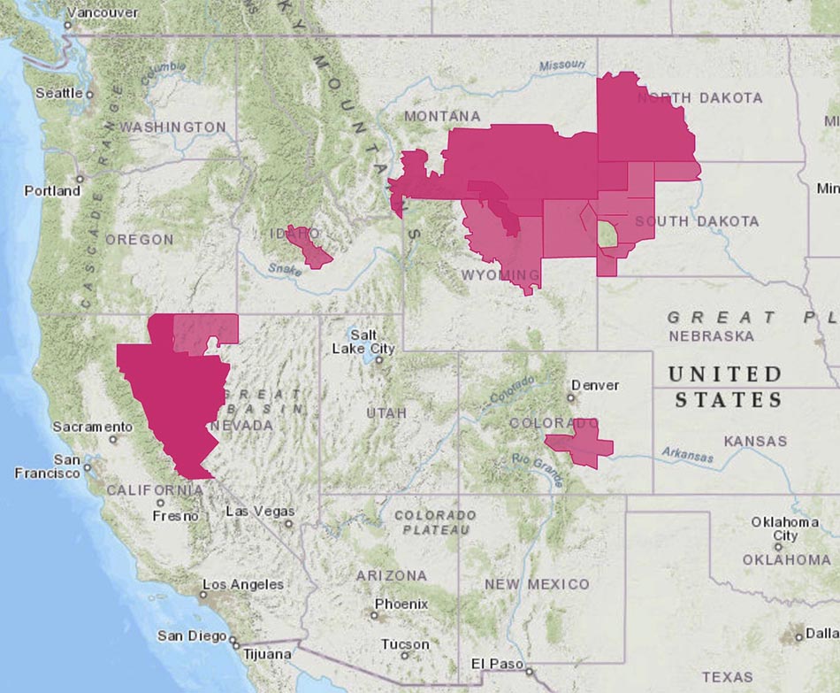
Red Flag Warnings. The areas in CA, NV, ID, and CO expire Monday evening. The areas in ND, SD, WY, and most of MT expire Tuesday evening.
A frontal passage is bringing strong winds into most of the Western U.S., prompting Red Flag Warnings in seven states. The Red Flag Warnings generally expire Monday night except in North Dakota, South Dakota, Wyoming, and most of the areas in Montana, which expire Tuesday evening.
The cumulative precipitation forecast through Saturday evening shows at least a small amount of precipitation occurring in many western areas, but many locations will receive less than 0.10″. Even some snow or rain/snow mix is in the forecast for portions of Oregon, Washington, Nevada, and Idaho.
Most of the southern two-thirds of California and Nevada are expected to remain dry through Saturday.
Forecast for cumulative precipitation, Monday evening through Saturday evening.
Lightning with little or no rain could start more wildfires
Forecast for lightning with little or no precipitation for 6 a.m. MDT Thursday until 6 a.m. MDT Friday.
Areas in 10 western states are included in forecasts for isolated or scattered thunderstorms with little or no rain Thursday afternoon and night, prompting Red Flag Warnings.
Nationally 23,467 firefighters are actively attempting to suppress 58 large fires and another 47 are being managed under a less than full suppression strategy. If this dry lightning event in drought-affected desiccated vegetation creates a new round of wildfires it would put additional stress on the wildfire suppression system that is already struggling to mobilize enough personnel and equipment for the existing 105 fires. Only one of the 16 Type 1 Incident Management Teams is available for new fires.
The National Weather Service predicts “…dry and breezy conditions conducive to fire spread across portions of the western Great Basin northeastward to the northern High Plains. Deep-layer ascent associated with the approaching upper trough will also support isolated to scattered thunderstorms across the western Great Basin and portions of the Pacific Northwest into the northern Rockies. Several fire starts will be possible where thunderstorms occur given the extremely dry fuels in place.”
Some locations from central Nevada northwestward to central Oregon and eastward to south-central Montana could receive more than half an inch of rain, but lightning could occur with no rain. Of particular concern is the area from central Oregon into far Northern California where fire managers should expect dry thunderstorms.
Red Flag Warnings Sept. 9, 2021.
The analysis in the tweet below raises the possibility of lightning with little or no rain in California’s South Bay, Central Coast, Santa Cruz Mountains, and the Los Padres National Forest in Monterey County. This area is under a Red Flag Watch.
Important update in the fire weather discussion by @NWSBayArea noting more widespread lightning potential with incoming weather pattern (not limited to the North Bay and East Bay) this is in line with evening model and satellite trends (1/2) #CAwx#FireWxpic.twitter.com/eqYUECguRI
Near-surface smoke forecast for 4 a.m. MDT August 5, 2021.
Most of the United States has some degree of smoke due to the fires in the western states and Canada, but the lighter concentrations may not be noticeable to most residents. If you have red sunrises and sunsets, it could be because of the smoke. Above is the near-surface smoke forecast for 4 a.m. MDT August 5, 2021.
Below are the Red Flag Warnings and Fire Weather Watches, issued August 4, 2021.
Many areas will experience temperatures above 100 degrees for the next several days
Hot Dry Windy Index, central Oregon.
The extreme heat that is gripping the Northwest this week is establishing weather conditions that are favorable for wildfires to spread more rapidly than usual. The Hot Dry Windy Index for Central Oregon on Monday and Tuesday is far above the 95th percentile. Other locations in Oregon and Washington also show the HDWI at high levels this week, generally above the 90th percentile and higher. (We first wrote about the HDWI in 2019.)
Many areas in the Northwest will have high temperatures above 100 degrees for the next several days. Here is an excerpt from an article published Monday at Oregon Public Broadcasting:
Seattle, Portland and other cities broke all-time heat records over the weekend, with temperatures soaring well above 100 degrees Fahrenheit. Forecasters said Monday would be worse, with the mercury possibly hitting 110 F in Seattle and 115 F in the Portland area before it begins to cool Tuesday.
In Eugene, the U.S. track and field trials were halted Sunday afternoon and fans were asked to evacuate the stadium due to extreme heat. The National Weather Service said it hit 110 F in Eugene, breaking the all-time record of 108 F. Portland reached 112 F Sunday, breaking the all-time temperature record of 108 F, which was set just a day earlier.
The temperature hit 104 F in Seattle. The weather service said that was an all-time record for the city better known for rain than heat and was the first time the area recorded two consecutive triple digit days since records began being kept in 1894.
The heat wave stretched into British Columbia, with the temperature in Lytton, a village in the Canadian province, reaching 115 F Sunday afternoon, marking a new all-time high recorded in Canada.
Red Flag Warnings June 28, 2021.
Red Flag Warnings are in effect Monday for a number of areas in California, Washington, and Oregon. The Fire Weather Watch areas on the map above for locations in California and Nevada are for thunderstorms and strong outflow winds Tuesday afternoon through late Tuesday night.
So far the extreme heat has not led to large fires in Washington and Oregon. Monday’s Situation Report does not include any that are less than 95 percent contained. However the 1,446-acre Lava Fire near Weed, California, 37 miles south of the Oregon Border, bears watching. Started from lightning on June 25, it will be subject to winds gusting to 26 mph Monday afternoon.