Wildfire briefing, January 13, 2014

One resident dead and 49 homes destroyed in Australian bushfire

One person collapsed and died on the roof of his house while spraying water to defend his home from a fire in the Perth hills of Western Australia on Sunday. The 62-year old man’s house was not damaged while the 650-hectare (1,606 acres) fire burned 49 others in the Shire of Mundaring. One resident tried to get back to their house on Monday afternoon and suffered burns to the hands and feet.

More information.

Three homes burn in Kansas wildfire

At least three homes burned Sunday in a large grass fire near the Kansas-Missouri border. The 600-acre fire was pushed by very strong winds which caused problems for the firefighters that responded from both Kansas and Missouri. Cherokee County officials said the fire may have been caused by a power line that failed due to the wind.

Wind speeds in Missouri and Kansas,  January 12, 2014
Wind speeds in Missouri and Kansas, January 12, 2014

Red Flag Warnings, January 13

Red Flag Warnings, January 13, 2014
Red Flag Warnings (red) and Fire Weather Watches (beige), January 13, 2014

Areas in southern California, Texas, Oklahoma, and Kansas are under Fire Weather Watches and Red Flag Warnings today.

UPDATE at 6:25 p.m. PST, January 13, 2014. The Red Flag Warning areas in California have grown:

Red Flag Warnings, California, 1-13-2014

More information.

2014 MAFFS Commander named

North Carolina resident Col. Charles D. Davis III will command the national military mission charged with combating wildland fires using C-130 aircraft outfitted with the Modular Airborne Fire Fighting System.

Col Charles D Davis III
Col. Charles D Davis III, USAF photo by Master Sgt. Patricia Moran

“MAFFS is a team effort,” said Davis, who also commands the Operations Group at the North Carolina Air National Guard’s 145th Airlift Wing based at Charlotte Douglas International Airport in Charlotte, N.C. “We protect lives and property from forest fires, and I’m proud to be a part of it.”

As commander of the Air Expeditionary Group Wildland Fire Fighting, Davis will lead three Air National Guard and one U.S. Air Force Reserve Command units that fly military C-130 aircraft and use them as aerial tankers. Headquartered in Boise, Idaho, the Group controls MAFFS operations nationwide at the direction of the U.S. Forest Service.

A U.S. Air Force master navigator with more than 5,300 hours of military flying time, Davis, of Weddington, N.C., has more than 1,000 hours of combat time earned supporting Operations Enduring Freedom and Iraqi Freedom. In civilian life, he is an Airbus A330 Flight Crew Training Instructor at U.S. Airways.

Arizona legislators consider bills related to hotshots’ deaths

State legislators in Arizona are considering bills that are related to wildfire management and the deaths of the 19 members of the Granite Mountain Hotshots. The firefighters were entrapped and killed on the Yarnell Hill Fire near Yarnell, Arizona on June 30, 2013.

  • The state organization responsible for managing the Yarnell Hill Fire is requesting a budget for the Arizona State Forestry Division that is nearly double what they received in the fiscal year that ends June 30.
  • A bill is being considered that would allow local governments to ban the sale of certain fireworks.
  • Another bill seeks to clarify what autopsy documents and photos are available to the public. County authorities refused to release autopsy reports for the Yarnell Hill firefighters.
  • Some legislators want the state to buy the state trust land where the hotshots died so it can be preserved as a memorial.
  • Legislators are considering helping the city of Prescott with its costs related to the hotshots’ deaths, but they may wait until the 100+ claims and/or lawsuits are settled before proposing anything specific.
  • They may propose legislation that would at least provide life insurance for public safety workers.

Type 2 helicopter contracts contested

WorldWind Helicopters has protested the contracts that were awarded for 31 Type 2 helicopters used to fight wildland fires. On December 17 the U.S. Forest Service announced exclusive use contracts for the award period that began December 17 and ends April 30, 2015 with options for three additional years. The solicitation was first announced on April 5, 2013 and took over eight months to complete.

More information.

Wing box replacements in the USFS C-130s

Coast Guard C-130H No 1714
Coast Guard C-130H No 1714, October, 2008. This is one of the seven C-130s being transferred to the U.S. Forest Service. Photo by PhantomPhan1974

The legislation that enabled the transfer of seven C-130H aircraft from the Coast Guard to the U.S. Forest Service to serve as air tankers required that the wing boxes be replaced and other maintenance be performed.

Fire Aviation has more information about the replacement of the wing boxes and other steps that must be taken to convert the C-130Hs into air tankers.

Red Flag Warnings, January 12, 2013

Red Flag Warnings, January 12, 2014

The extreme fire danger we told you about yesterday for some areas in southern California has grown from a two-day event to a Red Flag Warning for three days, Sunday night through Wednesday, and now encompasses most of southern California. Forecasters are expecting the very low-moisture fuels to be exposed to strong winds and low humidities.

Some areas in New Mexico, Texas, and Oklahoma are also under a Red Flag Warning for today, Sunday.

The Red Flag Warning map was current as of 10:10 a.m. MDT on Sunday. Red Flag Warnings can change throughout the day as the National Weather Service offices around the country update and revise their forecasts. For the most current data, visit this NWS site.

Red Flag Warning, Sierra Nevada

Red Flag Warnings in California, December 30

Red Flag Warnings for elevated wildfire danger have been issued by the National Weather Service for some areas in California through 4 p.m. PST Monday for very low humidities in the southern Sierra Nevada and the Tehachapi Mountains. This includes the Kern County Mountains, the Sierra Nevada from Yosemite National Park to Kings Canyon National Park, and the Tulare County Mountains.

Winds are expected to be northeast at 5 to 15 mph with gusts to 20, along with relative humidities of 10 percent or less.

The Red Flag Warning map was current as of 10:41 a.m. MDT on Monday. Red Flag Warnings can change throughout the day as the National Weather Service offices around the country update and revise their forecasts. For the most current data, visit this NWS site.

Elevated wildfire danger in southern California Sunday

(Originally published at 9:29 a.m. PST, December 28, 2013; updated at 10 a.m. PST December 29, 2013)
California Red Flag graphic December 28The National Weather Service has issued Red Flag Warnings for elevated wildfire danger in some areas of California Saturday night through Sunday. The areas affected include the greater Bay area, the southern Sierras, and in southern California the counties of Los Angeles and Ventura. Santa Ana winds are expected to gust in the 50 to 60 mph range across the mountains with occasional gusts to 70 mph. In the coastal and valley areas 40 to 55 mph winds are expected. Humidities will likely lower into the teens and single digits on Sunday. The winds will diminish Sunday night but the warm and dry conditions will persist into Monday.

AT 9:53 PST on Sunday morning the weather station at Chilao north of Los Angeles recorded 8 percent relative humidity, sustained winds of 42 mph, and wind gusts to 67 mph.

Red Flag Warnings in California, December 29

Christmas Red Flag Warnings in California

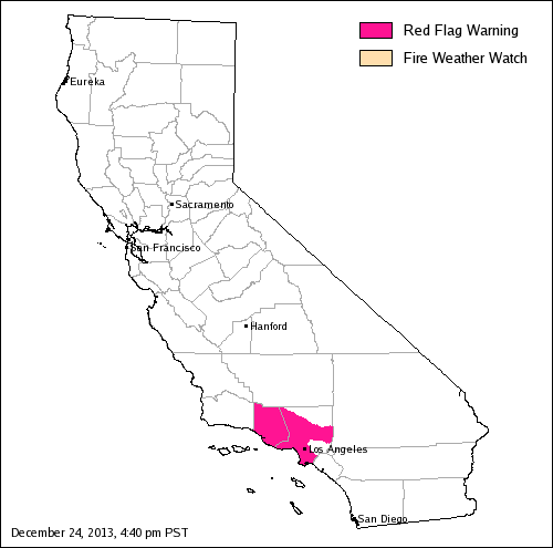
Map of Red Flag warning, California, December 24, 2013The beautiful weather that southern Californians enjoy throughout much of the year comes with a price at times. This year their Christmas present is a Red Flag Warning for Christmas day and Thursday for areas in Ventura and Los Angeles Counties. The warm, dry, weather with breezy offshore winds will persist through Saturday.

For Christmas day and Thursday weather forecasters are predicting wind gusts of 45 to 50 mph in the mountains and gusts between 35 and 40 in wind prone valleys. Relative humidities will reach into the lower teens by late Wednesday morning and into the single digits on Thursday. These weather conditions paired with extraordinarily dry fuels will produce elevated to critical fire weather conditions.

The Red Flag Warning map was current as of 4:40 p.m. PST on Tuesday. Red Flag Warnings can change throughout the day as the National Weather Service offices around the country update and revise their forecasts.


Thanks go out to Ken

California: Red Flag Warning

wildfire Red Flag Warning, November 4, 2013

The National Weather Service has issued a Red Flag Warning for some areas in Los Angeles and Ventura Counties in southern California for Monday evening through Tuesday night for strong northeast winds and low humidity. The wind is expected to gust up to 35 or 50 mph, depending on the area, along with a relative humidity in the low teens or single digits.

The NWS in California has started producing graphics like the one below, to inform the public about weather events like this.

Red Flag Warning graphic, November 4, 2013

More details.

The Red Flag Warning map was current as of 1:40 p.m. MDT on Monday. Red Flag Warnings can change throughout the day as the National Weather Service offices around the country update and revise their forecasts. For the most current data, visit this NWS site.


Thanks go out to Ken