Red Flag Warnings, February 19, 2013

Red Flag Warning, 2-19-2013

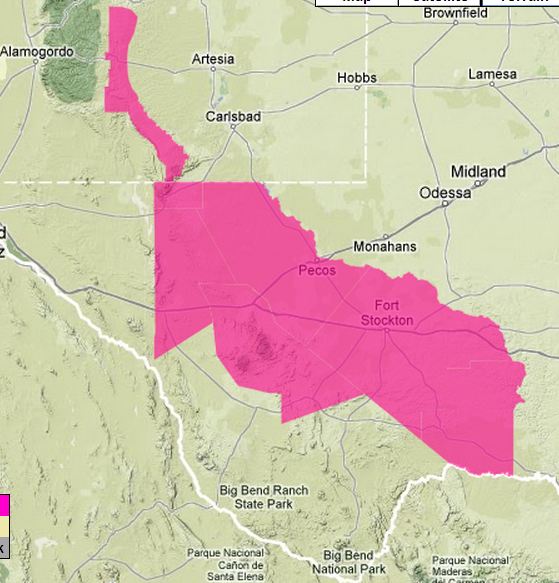
Areas in southern Arizona, southern New Mexico, and western Texas are under a Red Flag Warning today for strong winds and low relative humidities. In Arizona and New Mexico it is in effect from 1 p.m. until 7 p.m. MT, and in Texas, from noon until 6 p.m. MT.

The Prescott National Forest is working a fire (map), according to a report on Twitter from @SWCCNewsNotes at 10:24 a.m. today:

Crooks fire

The fire was discovered late in the day on Monday, and firefighters planned to take suppression action on it Tuesday morning. It is located in Crooks Canyon, about 2.5 miles southwest of historic Palace Station.  More info HERE about the Crooks Fire.

When wildfires start in these areas, firefighters need to keep in mind that the contracts for legacy large air tankers expired at the end of 2012, and currently no large air tankers are under national exclusive use contracts. It as has been 1 year, 2 months, and 19 days since the U.S. Forest Service issued a solicitation for next-generation large air tankers, but no contracts have been awarded.

***

The map above was current as of 10:30 a.m. MT on Tuesday. Red Flag Warnings can change throughout the day as the National Weather Service offices around the country update and revise their forecasts. For the most current data, visit this NWS site.


Thanks go out to Kelly

Red flag warnings for portions of New Mexico, Texas, and Florida

Red Flag Warning, Texas-NM, 2-18-2013
Red Flag Warning, Texas and New Mexico, 2-18-2013

The National Weather Service has issued a Red Flag Warning for dry and windy conditions between 8 a.m. and 5 p.m. MT today in the Guadalupe and Davis mountains, Van Horn, Highway 54 corridor, Reeves County, Upper Trans Pecos, Stockton Plateau, and Terrell County. The NWS forecast predicts the winds will be 20 to 30 mph with the relative humidity between 5 and 10 percent.

There is also a Red Flag Warning for an area in the Florida panhandle between Pensacola and Tallahassee until 6 p.m. CST today for a relative humidity below 35 percent and an Energy Release Component at or above 20.

In case there is a fire:

The U.S. Forest Service does not have any large air tankers on exclusive use contracts at the present time. They issued a solicitation for “next generation” air tankers 15 months ago, but no contracts have been awarded. The contracts for the existing Korean War vintage air tankers, and Neptune’s new-ish BAe-146s, expired in 2012. Usually air tankers come on duty in Alamorgordo, New Mexico in mid-February and in Boise in late February.

***

The map above was current as of 12:10 p.m. MT on Monday. Red Flag Warnings can change throughout the day as the dozens of National Weather Service offices around the country update and revise their forecasts. For the most current data, visit this NWS site.

Colorado: Red flag warning

Red Flag Warning, Colorado, Jan. 23-24, 2013

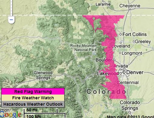
The National Weather Service issued a Red Flag Warning Wednesday afternoon for the front range of Colorado from the Wyoming border south almost to Colorado Springs. It will be in effect until 5 p.m. MT January 24. Conveniently for the weather forecasters, the extreme fire weather stops EXACTLY at the Wyoming/Colorado state line.

Here is the text from the announcement:

***

LARIMER AND BOULDER COUNTIES BETWEEN 6000 AND 9000 FEET, JEFFERSON AND WEST DOUGLAS COUNTIES ABOVE 6000 FEET, GILPIN, CLEAR CREEK, NORTHEAST PARK COUNTIES BELOW 9000 FEET-

…RED FLAG WARNING IN EFFECT UNTIL 5 PM MST THURSDAY FOR WIND AND LOW RELATIVE HUMIDITY FOR THE FRONT RANGE FOOTHILLS…

THE NATIONAL WEATHER SERVICE IN DENVER HAS ISSUED A RED FLAG WARNING FOR WIND AND LOW RELATIVE HUMIDITY…WHICH IS IN EFFECT UNTIL 5 PM MST THURSDAY.

* AFFECTED AREA…FIRE WEATHER ZONES 215 AND 216.

* TIMING…TONIGHT AND THURSDAY…WITH THE MOST CRITICAL CONDITIONS LATE TONIGHT AND THURSDAY AS WINDS INCREASE.

* WINDS…WEST 15 TO 20 MPH WITH GUSTS 30 MPH THIS EVENING INCREASING TO 20 TO 30 MPH WITH GUSTS AROUND 45 MPH BY THURSDAY AFTERNOON.

* RELATIVE HUMIDITY…SINGLE DIGIT HUMIDITIES LATE THIS AFTERNOON ONLY RECOVERING TO 25 TO 35 PERCENT TONIGHT. HUMIDITIES THEN DROPPING BACK TO AROUND 15 PERCENT THURSDAY MORNING WITH SOME IMPROVEMENT THURSDAY AFTERNOON.

* IMPACTS…EXISTING WILDFIRES OR NEW FIRE STARTS MAY EXPERIENCE RAPID FIRE GROWTH DUE TO THE VERY DRY FUELS…LOW HUMIDITIES…AND GUSTY WINDS. THE MOST CRITICAL CONDITIONS WILL OCCUR ON SOUTHERN EXPOSURES AND AREAS WITH NO SNOW COVER.

***

The map above was current as of 8:10 p.m. MT on Wednesday. Red Flag Warnings can change throughout the day as the dozens of National Weather Service offices around the country update and revise their forecasts. For the most current data, visit this NWS site.


Thanks go out to Chris.

Red Flag Warning for southern California

Red Flag Warning Southern California
Red Flag Warning 9:20 a.m. PT, December 9, 2012. NWS.

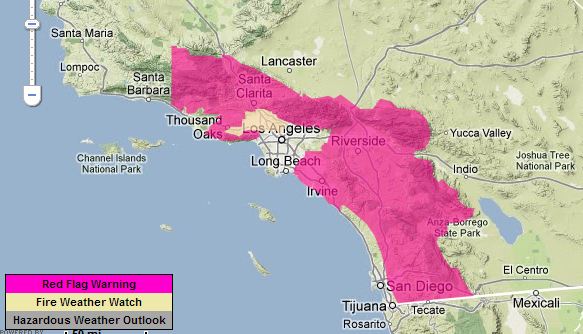
A Red Flag Warning is in effect for portions of the mountains and inland valleys of southern California Sunday night through Tuesday. The forecast calls for gusty northeast winds and low relative humidities. The strongest winds will be Sunday night and Monday with sustained winds of 15 to 30 with gusts up to 50 mph. The lowest humidities will occur Monday. The details vary across southern California — the specifics can be found at the National Weather Service.

The map was current as of 9:20 a.m. PT on Sunday. Red Flag Warnings can change throughout the day as the dozens of National Weather Service offices around the country update and revise their forecasts. For the most current data, visit this NWS site.

Red Flag Warnings, December 2, 2012

Wildfire Red Flag Warnings - December 2, 2012
Red Flag Warnings – December 2, 2012

On the second day of winter Red Flag Warnings for extreme wildfire danger are affecting portions of Colorado, Nebraska, Kansas, and and New Mexico.

One of the areas affects the Fern Lake Fire in Colorado where the warning will be in effect from noon Sunday until 6 a.m. Monday. The forecast the fire area for Sunday predicts southwest winds of 15 gusting to 24 mph, a high temperature of 51, sky cover of 49 percent, and a minimum relative humidity of 24 percent. However Sunday night will see the winds increasing to a maximum 41 with gusts to 62 along with a 22 percent chance of rain. The humidity will max out Sunday night at 75 percent.

The map was current as of 10:26 a.m. MT on Wednesday. Red Flag Warnings can change throughout the day as the dozens of National Weather Service offices around the country update and revise their forecasts. For the most current data, visit this NWS site.

Red Flag Warnings for September 10

Red Flag Warnings, September 10, 2012

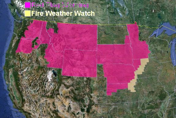
The map shows Red Flag Warnings in effect for today.

I wonder if the weather forecasters at the National Weather Service realize that when their map shows weather patterns adhering to state boundaries it reduces the credibility of their product. This map brings up some questions… are there really no warnings for Utah, Colorado or western North Dakota? Or, are there really warnings for all of Wyoming and South Dakota? Which portions of the map are accurate?

UPDATE at 9 a.m. September 11, 2012:

I asked Darren R. Clabo, the South Dakota State Fire Meteorologist, for his insight about this issue, and he was kind enough to provide the following:

…It really has to do with the NWS Local Forecast Area boundaries and the boundaries of the individual GACCs.

Here is the link that shows the local NWS office coverage areas as the NWS issues the Red Flag Warning (RFW). Each individual office has the responsibility to issue RFWs for their forecast area. These areas encompass distinct counties, some of which have common borders with other states. Each NWS forecast office does talk to neighboring offices to try to make their forecasts ‘mesh’ but often times, one office will issue a warning while another will not; it all depends on forecaster confidence in the particular weather situation.

It can even get more confusing: The GACCs, in concert with the NWS, determine the criteria for a RFW for their region (due to the different climates within the GACCs). For example, the Rocky Mountain GACC has specific RFW criteria, while the Northern Rockies GACC has a slightly different RFW criteria. If we look at western SD, Harding County typically sees more RFWs than the rest of West River. This is because Harding County is in the Northern Rockies GACC while the rest of SD is in the Rocky Mountain GACC. Furthermore, the GACC boundaries do not correspond to the NWS local office boundaries which contribute to the confusion as well.

Geographic “boundaries” in meteorology always present large hurdles in terms of communicating a forecast, especially when it comes to forecast areas. The zero-order boundaries for RFWs on the map do look goofy but I am not sure how else they could go about it.

Hope this helps-