Weather conditions during the tragedy at Yarnell Hill, and where do we go from here

We first wrote about the thunderstorm that may have contributed to the June 30 deaths of the 19 firefighters on the Yarnell Hill Fire, June 30 at 6:58 MST. But since that information is buried in a long article about the fire, and a little more information has emerged, we are summarizing the facts about the weather conditions that tragic Sunday afternoon. We also have some suggestions for providing firefighters with weather warning information that could save lives.

The formal investigation into the deaths, what caused them and any lessons to be learned, is just beginning. The results will probably not be known for many months. We will leave it up to the investigators to determine why it happened and what decisions were made before and during the incident. But the facts about the weather that day have already been recorded in various ways.

Carrie Dennett, a Fire Information Officer with the Arizona State Forestry Division, said the Arizona Dispatch Center received a call at 4:47 p.m. MST, June 30, that firefighters on the Yarnell Hill Fire had deployed fire shelters. The Dispatch Center was not in direct communication with firefighters on the ground at the fire. The information would typically have been relayed from the local Yarnell Hill Fire organization up through lower level dispatch offices.
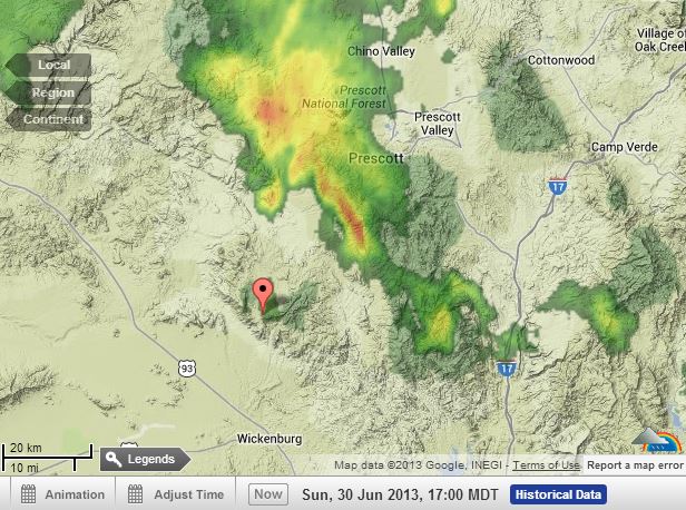
Radar at 5 pm MDT, June 30, 2013 The pointer is at Yarnell, Arizona.
Radar at 4 p.m. MST, June 30, 2013 The pointer is at Yarnell, Arizona. WeatherUnderground.

The radar map above from WeatherUnderground at 4 p.m. MST June 30 shows a large thunderstorm cell north and northeast of the fire at Yarnell, Arizona. The pointer is at Yarnell. At 10:55 a.m., according to data from the MODIS satellite, the fire was approximately a mile or so north and northeast of the town, between the town and the approaching thunderstorm. At that time and until after 4 p.m., the wind blowing from the south-southwest and the southwest, most likely would have caused the primary spread of the fire to be toward the northeast.

Animations of weather satellite images that afternoon HERE and HERE, show the development and movement of the thunderstorm into the fire area. The red “X” and circle mark the approximate location of the fire.

Before and after 4 p.m. the cell was moving toward the southwest, and may have produced strong winds that changed the wind direction by 180 degrees (see below) and may have been the reason the fire moved into Yarnell. It also could have caught firefighters by surprise.

From 10 a.m. until 4 p.m. local time at the Stanton RAWS weather station four miles south of the fire, the wind was from the south-southwest or southwest, but between 4:01 p.m. and 5:01 p.m. it began blowing from the north-northeast at 22 to 26 mph gusting up to 43 mph — a 180-degree change in the wind direction.
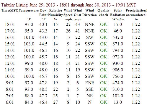
Data from Stanton RAWS weather station, near Yarnell, AZ
Data from the Stanton RAWS weather station, four miles south of Yarnell, AZ, June 30, 2013

We were told by a spokesperson for the fire that the location of the firefighters when they died was between the fire and Yarnell, which would put them north or northeast of the town. Michelle Lee of the Arizona Republic told us that they were about one quarter mile southwest of Glen Ilah estates, “in the mountains”. Glen Ilah is on the southwest side of Yarnell. Anyone in that area between 4 and 5 p.m., who previously had the wind at their backs for seven hours with the fire moving away from them, may have suddenly and unexpectedly found the fire heading toward them at a rapid rate, pushed by winds gusting over 40 mph. Wind direction changes like this can be caused by strong outflowing winds from a thunderstorm in the dissipating stage.

At 5:01 p.m. the temperature was 95 degrees and the relative humidity was 17 percent. That, coupled with sustained winds of 26 mph with gusts over 40 mph, could have caused the rate of spread to increase to the point where it would have been impossible for any firefighting resources, in the air or on the ground, to implement any kind of effective fire suppression action, especially at the head of the fire which was moving rapidly toward Yarnell.

The Weather Forecast

A Type 3 Incident Management Team transitioned to assume command of the fire at 10 a.m. on June 30. That morning the fire had burned less than 1,000 acres. Incident Meteorologists from the National Weather Service, IMETs, are frequently assigned to large wildfires. While they are on site they can provide a great deal of very detailed weather information to firefighters, monitoring the conditions closely and in constant communication with the IMTeam.

It would have been unusual for an IMET to be assigned to a fire of that size on June 30, and with a small Type 3 IMTeam. The next morning, however, an IMET did receive an order to respond to the fire along with a much larger Type 1 IMTeam.

But even without an on-scene IMET, firefighters have the capability to request from the National Weather Service a special “spot forecast” for a fire, and at least two were provided before the fatalities occurred, one at 8:33 p.m. MST on June 29, and another at 9:45 a.m. June 30. The latter one, according to the information at the top of the forecast, was requested at 9:39 a.m. MST and produced six minutes later, a remarkably short turnaround.

The spot forecast for the morning of the incident predicted “isolated thunderstorm activity”, and, “Partly cloudy. A slight chance of showers and thunderstorms in the afternoon”. The predicted wind was “east winds around 5 mph…becoming southwest with gusts up to 20 mph in the afternoon”.

It is extremely difficult or even impossible for meteorologists to predict exactly where and when thunderstorms will occur, especially if they are “isolated”, or few in number. It is also difficult to forecast the exact wind speed and direction under any conditions.

Where do we go from here?

Firefighters need to know when there is a sudden change in weather conditions that can threaten their safety. Since it will never be possible to have an IMET at every fire, there needs to be a concerted interagency effort involving the National Weather Service and the *land management agencies, state, local, and federal, to develop a system to provide firefighters with the situational awareness information they must have to reduce the probability that they will be surprised by a life-threatening change in the weather.

Firefighter’s Emergency Situational Awareness Device —  FESAD

We may need new developments in hardware for firefighters so that they can receive weather warning data directly from the source without going through layers of bureaucracy. The military probably already has something like this, but I envision a device with a 7-inch display that could receive satellite transmissions anywhere there is a clear view of the sky. Each firefighter would not need to have a Firefighter’s Emergency Situational Awareness Device, a FESAD — just provide one for every fire. It could be based on a satellite phone, would have a GPS receiver (like in most smart phones), and be capable of receiving text and images. A deluxe version might also function as a satellite telephone, so that the firefighter could call the weather forecaster to get more information. The person sending the data to the fire would not have to know the phone number of the receiver, but would draw a box on a map and any devices within that box would receive the data, without bothering others that would not be affected by the warning. When the FESAD arrives at a fire, the user could have it send a message registering its location so that warnings for that area could be received. This would also alert the on-duty Remote-IMET to add it to their watch list.

Alert who?

Remote-IMET (R-IMET)

The warning data could be sent to the fire by an NWS forecaster always on duty with the primary responsibility to remotely monitor weather conditions near multiple fires. (The NWS already does this for the entire nation for severe storm, tornado, and hurricane warnings.) For fires, let’s call them Remote-IMETS. Some of the Geographic Area Coordination Centers already employ full time fire meteorologists. With the right software they could perform this function.

An R-IMET would have the technology available to instantly transmit text and graphical data about an emerging dangerous condition directly to those on the ground without relying on telephones to filter the information down through various layers. An R-IMET would not have time to handle all of the IMET duties normally performed by an on-scene IMET, but would concentrate primarily on issuing urgent warnings that could affect the safety of firefighters.

What if …. there had been a FESAD and R-IMET available for the Yarnell Hill Fire 

FESADs and R-IMETs could save lives.

The iron is hot

There is a great deal of national interest right now in the deaths of the Granite Mountain 19. If any new initiatives that would cost money are going to be implemented, our Fire Leaders must strike now while the iron is hot. There may be a small window of two to four weeks during which there will be some sympathy nationwide and citizens and lawmakers are open to enhancing the safety of wildland firefighters, even if it involves spending money.

An example of a rapidly closing window of opportunity is the movement for controlling gun violence after a gunman fatally shot twenty children and six adult staff members at Sandy Hook Elementary School in Newtown, Connecticut. If the administration and lawmakers had taken action quickly, meaningful legislation would have had a much better chance of passing. Instead, they waited months, and achieved little.

*A side note

It pains me to describe the federal fire departments as “land management agencies”. Organizations whose primary mission is to grow trees, clean campground toilets, or manage visitors, do not have at the top of their To-Do List, “Provide real-time weather warning information for firefighters”. We need a National Fire Service.

National firefighter safety stand down, July 3, 2013

The National Multi-Agency Coordinating Group in a July 2 memo asked for a safety stand down, or operational pause, for the morning of July 3, 2013:

****

“National Firefighter Operational Safety Stand-down Tomorrow

NMAC Operational Pause

National Interagency Fire Center, 3833 S. Development Avenue, Boise, Idaho 83705

July 2, 2013

To: Geographic Area Coordination Centers

From: National Multi Agency Coordinating Group

Subject: July 3, 2013 Operational Pause in Remembrance

The wildland fire community, and the nation, deeply mourn the loss of nineteen firefighters from Prescott Fire Department’s Granite Mountain Interagency Hotshot Crew. Even as we mourn this tragic loss we must also remember and honor the other firefighters who have perished in the line of duty on other wildland fires this year.

The 2013 fire season is well underway and is likely to continue at a high intensity level for several more months. With that in mind, NMAC requests that all wildland fire personnel in the United States observe an Operational Pause in Remembrance on the morning of Wednesday, July 3.

As we remember our fallen, we must also consider those who survive and the challenges they face in dealing with the magnitude of such a loss. Agency leaders must make available the kinds of counseling and peer support that can help employees work through their emotions. The goal is to reduce the potential long-term impacts that are sometimes a consequence of normal human reactions to tragedy. Some wounds cut deeper, and take longer to heal, than others.

An operational pause is also a time for thoughtful reflection about risk (see “Resources” below). It is a time-out from daily operations – even while committed to an incident. It is a time to focus exclusively on the kind of work we do, our operational environment and the hazards we encounter there, how we assess risk, and the risk mitigations that can be employed to reduce risk to acceptable levels. It is a time to recognize the implications of the fact that in the hazardous wildland fire environment, risk can never be reduced to zero even with the best mitigation measures in place. It is a time to reflect on the fact that we can always take an operational pause to consider these things, even during high-tempo operations.

We ask that all fire managers and fire personnel take the time to thoughtfully take an Operational Pause in Remembrance. And we thank all firefighters and support personnel for their efforts.

/s / John Segar

Chair, NMAC

Resources:

A fresh look at the tragic Dude Fire

Dude Fire Newpaper
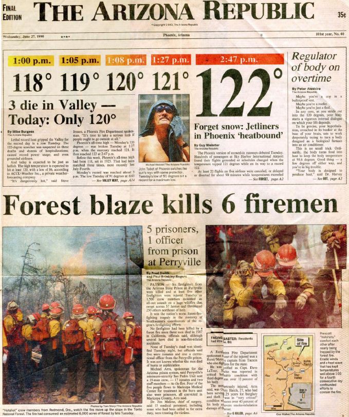
The front page of The Arizona Republic, June 27, 1990. (click to enlarge)

A journalist, who is also an editor at Time, Inc., has taken a fresh look at the Dude Fire, 23 years after 6 firefighters were entrapped and killed in Walk Moore Canyon north of Payson, Arizona, June 23, 1990 — a day when the temperature in Phoenix reached 122 degrees, grounding jetliners because there was no reliable data confirming that fully loaded commercial aircraft could operate in that kind of heat.

Jaime Joyce conducted extensive research about the fire, talking to firefighters who survived, families that had to bury their sons, investigators who determined what happened and how the equipment functioned, and yes, attorneys who dealt with legal issues long after the funerals. She unearthed facts, stories, and perspectives that never made it into the official reports.

Firefighters can learn many lessons from reading the investigation report which was completed less than a month after the accident by Dick Mangan, Ted Putnum, Patricia Andrews, and six others.

Reading articles like the one written by Ms. Joyce can also impress upon a firefighter, especially those in the early part of their careers, that things CAN go wrong, horribly wrong, and how important it is to be responsible for your own safety (if you SEE something, SAY something) and to maintain situational awareness.

Ms. Joyce’s account, published at The Big Roundtable, brings to light details that would not normally be found in government reports — it shines a light on the accident from a different perspective. It also covers the battles fought by survivors and the victims’ families for various forms of restitution, largely futile, that persisted for years after the smoke cleared.

Below is an excerpt from the article:

****

“…The burnover lasted about 15 minutes. [Fire] shelters are designed to withstand temperatures up to 1,200 degrees. It must have been hotter in the heart of the flame front, since some of the shelters started to delaminate, the aluminum exterior separating from the fiberglass lining.

Davenport, Love, and LaTour stayed put. They waited inside their shelters until the area cooled down. LaTour used his radio to call for help but no one answered on any of the channels. Through the chatter, he heard someone say that help was coming. When the men finally emerged about 45 minutes later, shaky and weak, they followed the dozer line toward Control Road, their tattered shelters wrapped around their bodies like capes. As they walked, LaTour told the men not to look at the devastation that surrounded them. “We have to get out,” he said.

On the way down, they met Hoke, who was still inside his shelter. He emerged from his cocoon and joined the survivors. Ellis appeared next. As he walked toward the men, with his shelter tied around his forehead, his skin and clothing burned, the life drained out of him. “I’m dead,” Ellis told the others, and then he sat down on a log and died.

No one was waiting for the men at Control Road. Again, LaTour radioed for help and got no response. He headed west with his men about 200 yards, which is where a Forest Service truck met them. The men climbed into the bed of the pickup and were taken to a clearing, where they were given first aid. They were brought to the base camp next and flown by helicopter to Maricopa Medical Center, in Phoenix.

Before the flame front hit, the Alpine Hotshots foreman, Jim “J.P.” Mattingly, and his men had been conducting a burnout in Walk Moore Canyon just north of Perryville, using gasoline-filled drip torches to light small fires in order to clear vegetation and stop the spread of the blaze. When Mattingly saw the fire approaching, he had ordered his men to run north up the canyon, in the opposite direction of Perryville and Navajo. He had stepped away from the safety zone to take in his surroundings when he came across Paul Gleason, superintendent of the Zigzag Hotshots, and Paul Linse, superintendent of Flathead. Mattingly told the men that Perryville and Navajo had gone back toward Control Road, and that nobody else should be heading north up the canyon. But Gleason wanted to make sure no one was left. “Do you mind if we go back that way?” he asked. No one objected.

Their actions defied human instinct…”

(end of excerpt)

****

We contacted Ms. Joyce to ask her how she became interested in the Dude Fire. In addition to granting us permission to publish an excerpt, she was kind enough to provide the following answers to our inquiry:
Continue reading “A fresh look at the tragic Dude Fire”

Southern California fuels and fire behavior advisory

One of the Predictive Services offices issued a Fuels and Fire Behavior Advisory for southern California. In this new one, most of Northern California has been temporarily removed due to the unseasonably cool and wet weather pattern. With the forecast for the weather pattern to make a dramatic change mid-week with strong high pressure developing over California for rapid drying/warming into the weekend, they anticipate Northern CA will once again warrant an advisory in the next 1-2 weeks.

****

Predictive Services

“Fuels and Fire Behavior Advisory
Southern California
June 25, 2013

Subject: Low live and dead fuel moistures, along with persistent drought have created the potential for active to extreme fire behavior in Southern California.

Discussion: All of California is experiencing drought conditions. Effects of lower than normal live and dead fuel moistures and observed fire behavior for 2013 are the focus of this advisory. Note that most of Northern CA was included in the previous advisory but has been temporarily removed due to forecasted widespread wetting rain. It is anticipated that area will warrant an advisory in the next couple weeks.

Difference From Normal Conditions: Drought conditions ranging from abnormally dry to severe exist and are expected to persist or intensify. The entire area is deficient in rainfall and snow pack, resulting in fuels that are 4-8 weeks ahead of normal drying/curing rates.

Concerns to Firefighters:

  • Energy Release Component (ERC) values at numerous weather stations are well above normal and many are at record maximums. Expect increased fire intensity and spread rates in these areas. Early season extreme fire behavior has been observed especially in brush fuel types. Anticipate increased spread rates, spotting, and active night time burning.
  • The combination of persistent drought and record-low rainfall and snowpack amounts has led to very low live and dead fuel moistures. Low 1000-hour fuel moistures have been evidenced by complete consumption of dead fuels on recent fires. Live fuel moistures for Chamise have already reached critical levels of 60% or less in many areas. Expect fires to ignite easier and spread faster. Anticipate higher resistance to control in all fuel types.
  • Active fire behavior can extend well into the night and early morning hours even with moderate RH recovery. Already this year, Southern California has experienced large fire activity and multiple team deployments. It is important to be mindful of and manage fatigue for all resources. Everyone, every day, returns home safely.

Mitigation Measures:

  • Local and inbound fire personnel need to be aware that fire behavior is exceeding normal expectations for this time of the year. Local briefings need to be thorough and highlight specific fire environment conditions. These include but are not limited to local weather forecasts, Pocket Cards, ERC’s, live and dead fuel moistures, and special fuel conditions such as mortality, Sudden Oak Death and frost killed brush, etc.
  • Suppression actions need to be based on good anchor points, escape routes, and safety zones. Remember LCES. Experienced lookouts are essential under these conditions.
  • Base all actions on current and expected behavior of the fire. Augment initial attack resources as incident activity dictates.
  • Review the most current Southern California 7-day Significant Fire Potential along with Daily, Monthly and Seasonal Outlooks at: http://www.predictiveservices.nifc.gov/outlooks/outlooks.htm

Area of Concern: The area of concern is the Southern California geographic area with the exception of 4 PSA’s: Central Valley, Central Mojave, Eastern Desert, and Lower Deserts. A map showing the areas of concern described in this advisory can be found at: National Fuel Advisories

Issued: June 25, 2013 (Note this advisory will be in effect for 14 days and will be reviewed/updated at that time.)”

Two fuels and fire behavior advisories for Colorado

The Rocky Mountain Geographic Area and the Upper Colorado River Fire Management Unit on the Colorado Western Slope issued two Fuels and Fire Behavior Advisories today. Below are the complete texts of both:

****

Predictive Services

“Fuels and Fire Behavior Advisory
Western Slope of Colorado
06/21/2013

Subject: Western Colorado is in the third year of drought. The situation is predicted to persist or intensify through July. There is increased risk of large fire development and intense fire behavior. Dry, heavy fuels at higher elevations could pose a greater risk of active fire behavior.

Discussion: The wet spring pattern that occurred during April and May has provided a brief reprieve. Live and dead fuel moistures are quickly returning to a condition that will support large fire growth.

Forecasts do not offer the prospect of live or dead fuels conditions improving through July.

Difference from normal conditions: Fuels are described by fire managers as being deceptively green. The visual greenness being observed can lessen the sense of fire potential. Live fuels, which had shown some improvement from late spring precipitation, are drying. On the Western Slope of Colorado, 100FM fuels are setting historically low values for the date, nearing the 3rd percentile, and moving into the range associated with historic large fires. Long-term drying has made large, higher elevation fuels, available as well.

Concerns to Firefighters and the Public:

  • Recent large fires on the Front Range and Western Slope have displayed intense and/or extreme fire behavior.
  • Long-range spotting, fire whorls, extreme fireline intensity and high winds have been observed and will continue to be control problems on both wildland and urban interface incidents.
  • Local preparedness planning and cooperation should be on-going.
  • Management of suppression resources rest and recovery as activity increases.

Mitigation Measures: Strategies for dealing with each of the specific circumstances listed above include using Predictive Service¡¦s forecasts of higher potential for large fire occurrence, rapid initial attack in those high risk areas, and daily fire and fuels briefings to suppression personnel.
Continue reading “Two fuels and fire behavior advisories for Colorado”

Another Fuels and Fire Behavior Advisory — this time, Arizona and New Mexico

Fuels and fire behavior advisoriesOne of the Predictive Services offices has issued another Fuels and Fire Behavior Advisory. The last one, issued June 10, was for California. This new one, dated June 16, is for portions of Arizona and New Mexico.

The advisory does not mention the “Southwest Monsoon,” an event that typically starts in early July and generally begins to draw the curtain on the fire season in Arizona, New Mexico, West Texas, southern Utah and southwestern Colorado.

Below is the full text of the advisory.

****

“Fuels and Fire Behavior AdvisoryPredictive Services

Arizona and New Mexico

June 16, 2013

Subject: Persistent multi-year drought across much of New Mexico and Arizona has dropped fuel moistures to critically low levels in the large dead and live foliar fuels. These critically low fuel moistures increase available fuel loading which contributes to and supports active crown fire in timber fuels when critical fire weather is present.

Discussion: The multi-year drought has reduced the fine fuel loading across most of the region so the focus for this advisory will be the timber fuels within the region.

Difference from normal conditions: Drought creates more available fuel in timber fuel types which will increase fire intensities, crown fire potential and difficulty of control for fire suppression resources. Short duration rain events provide only short term fuel moisture improvement in timber litter fuels (1, 10, and 100 hour dead fuels). Fuels rebound quickly to previous dryness levels. Short duration rain events provide no fuel moisture recovery in large dead and live foliar fuels.

Concerns to Firefighters and the Public:

  • Surface fire will quickly transition to crown fire and only requires low to moderate surface fire intensity to transition.
  • Active/running crown fire has produced long range spotting up to one mile under the influence of an unstable atmosphere.
  • Active fire behavior can extend well into night and early morning hours even with moderate RH recovery.
  • Thunderstorm activity will create a mosaic pattern of surface fuel moistures. Surface fire intensity and fire behavior may change abruptly when fires cross these boundaries of moist and dry surface fuels.

Mitigation Measures:

  • Local briefings need to be thorough and highlight specific fire environment conditions. These include but are not limited to local weather forecasts, Pocket Cards, ERC’s, live and dead fuel moistures, and special fuel conditions such as drought and insect mortality
  • Lookouts, both on the ground and in the air, can help identify the initiation and location of crown fire. They can also provide the location of resultant spot fires from active crown fire.
  • Firefighters should acknowledge that fire growth and fire behavior they encounter this year may exceed anything they have experienced before due to the drought factor. Normal strategies and tactics may need to be adjusted to account for the drought factor.

Area of Concern: Please reference the map posted on the National Fuel Advisory Page.

http://www.predictiveservices.nifc.gov/fuels_fire-danger/fuels_fire-danger.htm

The timber fuels within this area of concern are the target for this fire behavior advisory.”

****

(End of text)


Thanks go out to Ken