Wildfire activity increases in Manitoba and Ontario

The Red 023 Fire near Sandy Lake in Ontario made a 20 kilometer run Monday afternoon and night

wildfires Manitoba Ontario June 2 2019
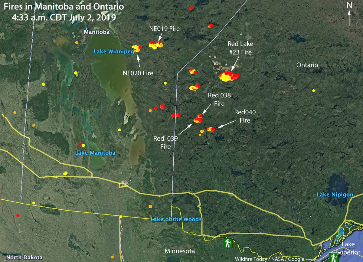
Map showing the locations of wildfires in Eastern Manitoba and northwest Ontario at 4:33 a.m. CDT July 2, 2019.

Wildfire activity in Canada has spread from British Columbia and Alberta, east to the provinces of Manitoba and Ontario. In the last several days about a dozen fires have grown much larger in Eastern Manitoba and Northwestern Ontario. Winds out of the west Monday afternoon and night forced some of blazes to grow substantially to the east and northeast.

The largest in the area is in Northwestern Ontario, the Red 023 Fire that started June 15. As illustrated in the map below, between 2:42 p.m. July 1 and 4:33 a.m. CDT July 2 the fire ran east for about 20 kilometers (13 miles). Early Tuesday morning it was 4 miles south of Sandy Lake and six miles southwest of the community of Keewaywin.

The Ontario Ministry of Natural Resources and Forestry’s latest estimate of the size of the Red 023 Fire was 37,390 Ha (92,392 acres). After the major run, our very, very unofficial estimate using satellite data estimates that it has grown to at least 54,000 Ha (130,000 acres).
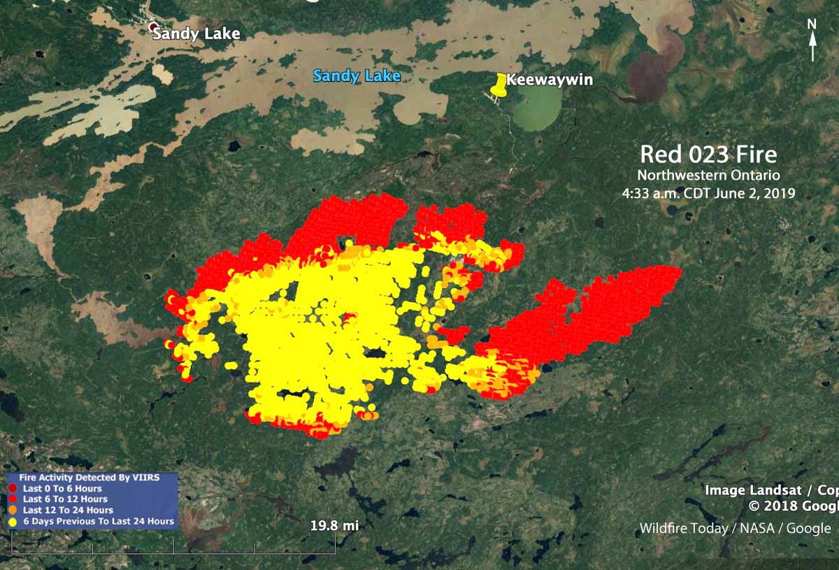
Map Red 023 fire Keewaywin Ontario Sandy Lake
Map showing heat on the Red 023 Fire detected by a satellite as late as 4:33 a.m. CDT July 2, 2019. The red areas burned between 2:42 p.m. July 1 and 4:33 a.m. CDT July2.

There are three large fires in Ontario northwest of Trout Lake that all started June 30. (See the map at the top of the article) The sizes were reported by the Ontario Ministry of Natural Resources and Forestry on July 1, 2019:

  • Red 038 Fire, 1,100 Ha (2,700 a)
  • Red 039 Fire, 10,000 Ha (24,700 a)
  • Red 040 Fire, 2,832 Ha (7,100 a)

Two of the larger fires in Manitoba are the NE 020 Fire and the NE 019 Fire, east of Lake Winnipeg and southeast of Playgreen Lake, both reported in mid-June. Their reported sizes are 11,000 Ha (27,000 acres) and 9,000 Ha  (22,000 acres), respectively.

The weather forecast for the Pikangikum, Ontario area through Saturday calls for temperatures in the mid to high 70s F, partly cloudy or sunny, winds generally out of the west during the day at 5 to 12 mph, and very little chance of rain.

The map below shows the forecast for the distribution of wildfire smoke from the fires in Alaska, Manitoba, and Ontario at 7 p.m. CDT July 3, 2019.

Smoke Forecast wildfires Canada
Forecast for the distribution of wildfire smoke at 7 p.m. CDT July 3, 2019, produced July 2 by the Canadian government. The forecast only includes the area within the black border.

Class action suit filed over health effects of burning sugar cane

Burning field sugar cane
Burning a field of sugar cane in Hawaii. Photo by bob Bangerter.

A class action lawsuit was filed in Florida Tuesday over the health effects of burning sugar cane fields.

The four people at the front of the room where the legal action was announced included, in addition to an attorney and a state legislator, Frank Biden, brother of former Vice President Joe Biden, and former Jacksonville Jaguars running back Fred Taylor.

Fields of sugar cane are sometimes burned before manual harvesting in order to remove the dry leaves and chase away or kill any lurking venomous snakes.

Below are excerpts from an article at the Sun-Sentinel:

There have been more than 100,000 cane field burns in Palm Beach County since 2004, according to former state Sen. Joe Abruzzo, who now serves as the director of government relations at the Berman Law Group, which filed the suit.

According to Abruzzo, there are also 700 hospitalizations for asthma in Palm Beach County for every 100,000 residents. That’s significantly higher than statewide numbers. According to the Centers for Disease Control, the hospitalization rate for asthma in Florida is 142.4 out of 100,000.

“The sugar companies, they have to take responsibility for this. If nothing more, they need to promote awareness and get down to the bottom of these health issues because the community is dying,” Taylor said. “The black snow that comes from the sky, people are breathing that stuff in. They’re getting sicker and sicker every day.”

The lawsuit accuses U.S. Sugar, Florida Crystals and other sugar producers of negligence, liability for any damages caused by the burning of the fields, and trespassing in that hazardous waste landed on the property of members of the class-action suit, among other things. The suit asks the court to institute a medical monitoring program for residents of Belle Glade, South Bay, Pahokee and nearby areas, as well as asking the court to force sugar companies to stop any future crop burnings.

Thanks and a tip of the hat go out to Bob. Typos or errors, report them HERE.

Wildfire smoke maps, June 23, 2019

Posted on Categories UncategorizedTags
wildfire smoke United States
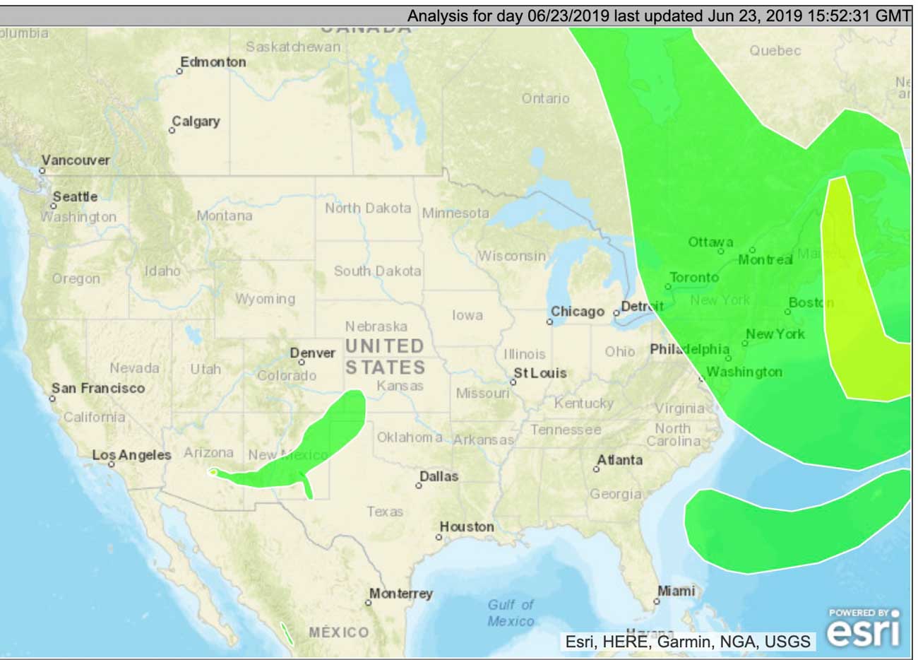
Made by NOAA in the United States, this map depicts the extent of wildfire smoke at 9:52 a.m. MDT June 23.

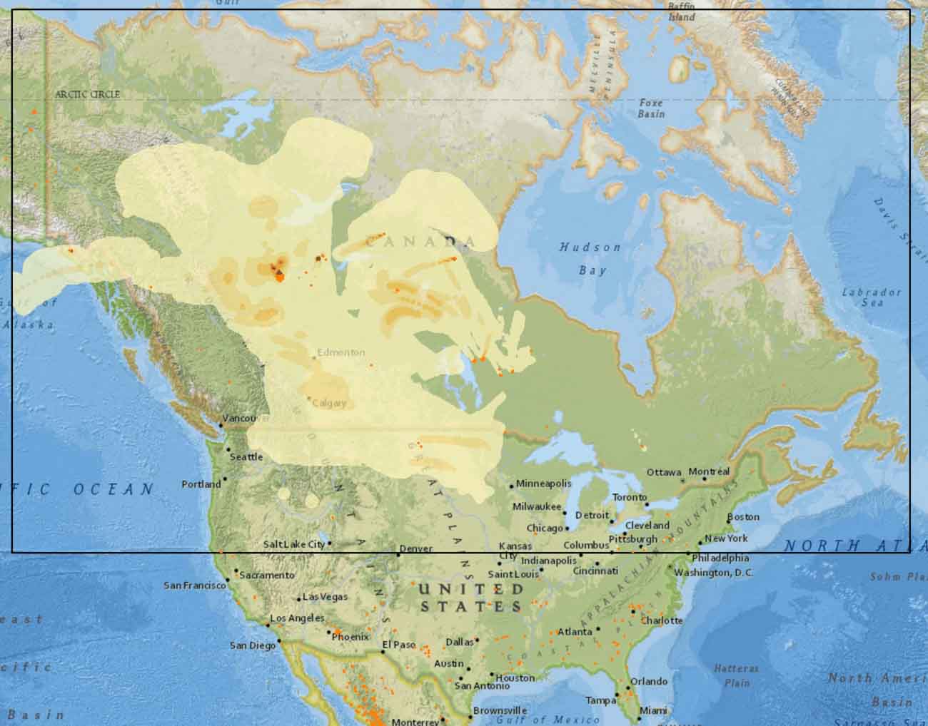
These maps, produced by agencies in Canada and the United States, show the distribution of smoke from wildfires in both countries.

The map above, made by NOAA in the United States, depicts the extent of wildfire smoke at 9:52 a.m. MDT June 23.

The one below, from the Canadian government, is a forecast for the maximum amount of smoke expected to occur today, June 23. It only applies to the area within the box with the black border, and does not predict for the southern half of the United States.

wildfire smoke Canada United States
From the Canadian government, this is a forecast for the maximum amount of smoke expected to occur today, June 23. It only applies to the area within the box with the black border, and does not apply to the southern half of the United States.
wildfire smoke Canada United States
From the Canadian government, this is a forecast for the maximum amount of smoke expected to occur today, June 23. It only applies to the area within the box with the black border, and does not apply to the southern half of the United States.

Arizona wildfire smoke to take more northerly track

Predicted to move into New Mexico, Colorado, Kansas, and Oklahoma by Friday evening

smoke forecast map fire wildfire
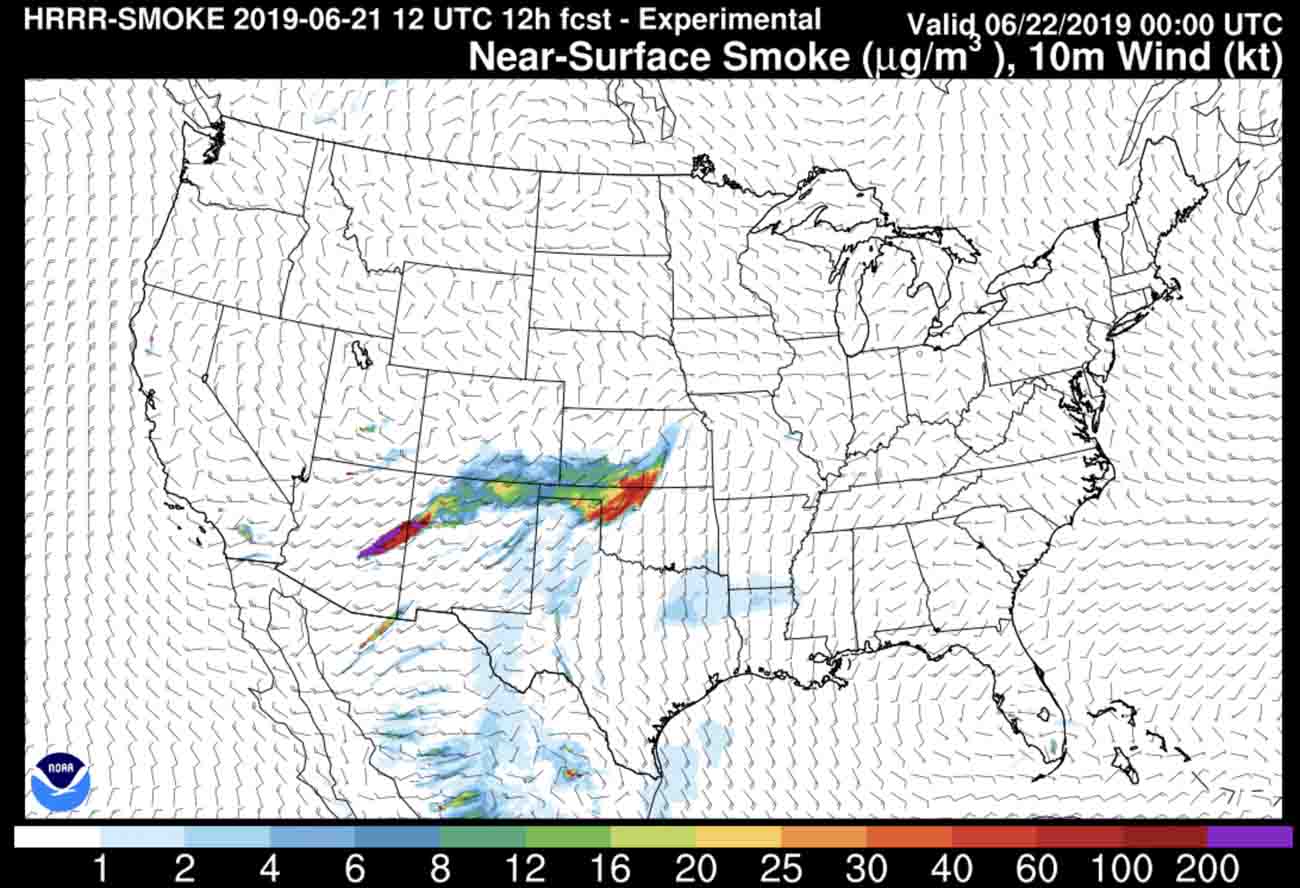
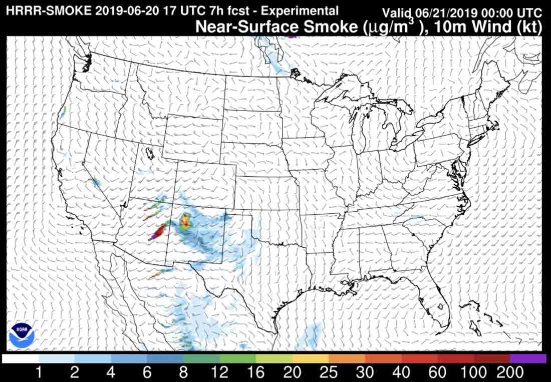
Forecast for the distribution of smoke from the Woodbury Fire, at 6 p.m. MDT June 21, 2019.

The massive smoke plume produced by the Woodbury Fire east of Phoenix will begin to take a more northerly track on Friday. The National Weather Service predicts that after it crosses Northern New Mexico it will move into Colorado, Oklahoma, and Kansas. States farther east could be affected during the weekend.

(To see all articles on Wildfire Today about the Woodbury Fire, including the most recent, click HERE.)

satellite photo smoke Woodbury Fire map wildfire
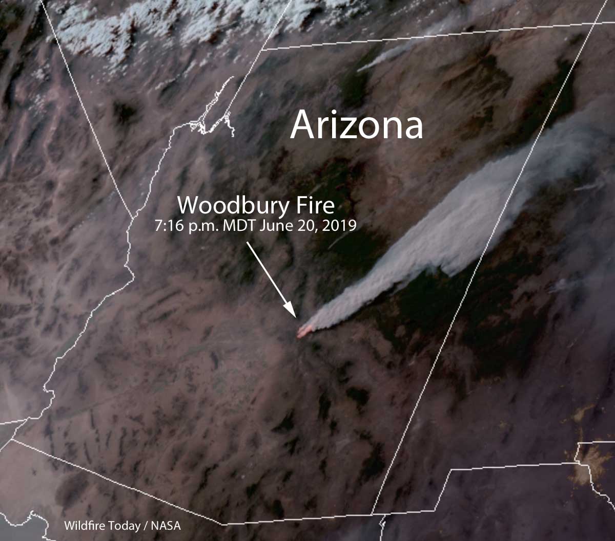
Satellite photo at 7:16 p.m. MDT June 20, 2019 showing smoke from the Woodbury Fire near Phoenix spreading to the northeast.
smoke Woodbury Fire map wildfire
The map shows the extent of wildfire smoke from Canada and Arizona at 10:35 p.m. MDT June 20, 2019.

Smoke from fires in Arizona affects New Mexico and Texas

satellite photo fires wildfires smoke Arizona
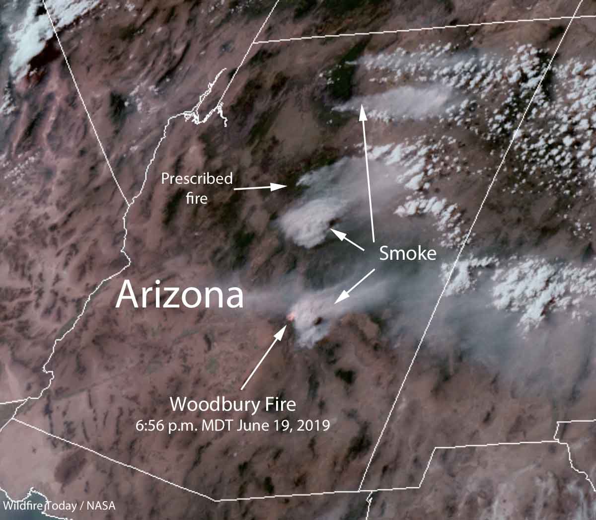
Satellite photo, at 6:56 p.m. MDT June 19, 2019 showing smoke from a prescribed fire and wildfires in Arizona.

Smoke from a prescribed fire southwest of Flagstaff, the Woodbury wildfire east of Phoenix, and other wildfires in northern Arizona was photographed from a satellite at 6:56 p.m. MDT June 19, 2019.

Much of the smoke is blowing into New Mexico and Western Texas.

fire smoke map arizona new mexico
Forecast for the distribution of smoke from fires, at 6pm MDT June 20, 2019.

Smoke from the Woodbury Fire near Phoenix will spread east into New Mexico and Texas

wildfire smoke forecast June 19, 2019
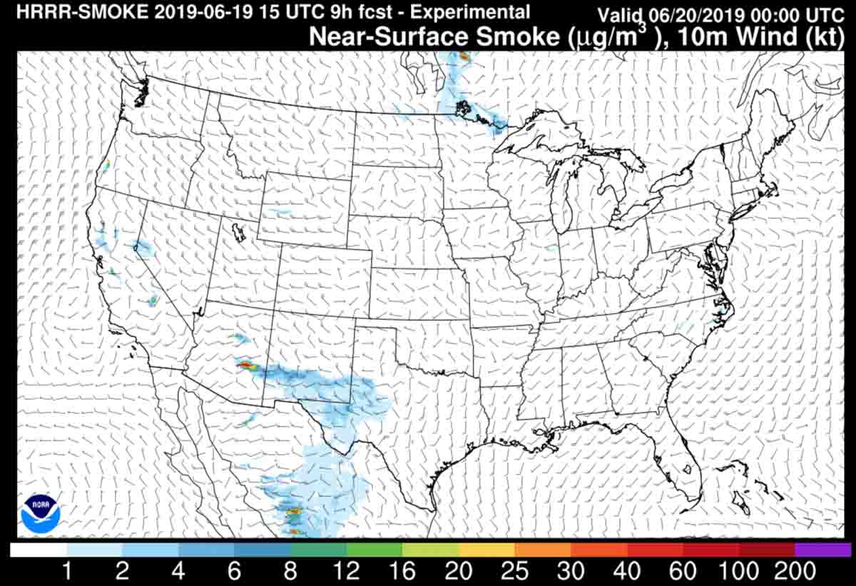
The smoke from the Woodbury Fire is expected to blow off to the east Wednesday into Southern New Mexico and Western Texas. The map depicts the forecast for 6 p.m. MDT June 19, 2019.

The smoke from the Woodbury Fire east of Phoenix is expected to blow off to the east Wednesday into Southern New Mexico and Western Texas. The map depicts the forecast for 6 p.m. MDT June 19, 2019.