A system that can send emergency notifications to every cell phone in a designated area was not used.
Soon after the Pocket, Tubbs, and Nuns Fires burned thousands of homes in northern California in the days following the October 8 wind event, local residents began asking why they received no emergency notifications on their cell phones.
The day before, all cell phones in Rincon Valley east of Santa Rosa loudly blared with a message about a child abduction in San Francisco about 48 air miles to the south, but the Amber Alert system was not used as the wildfires bore down on the densely packed communities in Sonoma County.
Tubbs Fire. Photo by Jeff Zimmerman.
Officials did use two other systems, Nixle and SoCo Alert, to send messages to less than 35,000 cell phone users. Those programs require people to opt-in or sign up in advance.
But most residents in Sonoma County did not receive any notifications by phone as the fires approached between 10 p.m. and 6 a.m. They found out as neighbors knocked on their doors or police drove around blasting sirens.
At least 23 people in Sonoma County died in the fires.
“I’m emotional when it comes to this, and I’m a rational guy,” said Patrick McCallum, who fled the fires with his wife, Judy Sakaki, president of Sonoma State University.
They burned their bare feet and ran for their lives as flames tore through their Fountaingrove neighborhood. By that point, about 4 a.m., the Tubbs fire, which started outside Calistoga 9 miles to the east, had been burning more than six hours. McCallum, however, was only awakened by a smoke alarm and the couple’s home already was on fire. The landline phone in the bedroom never rang.
The [Amber Alert] program is available to the Sonoma County Emergency Services division, housed within the county fire department. Emergency officials have said publicly they opted against using the program because they didn’t want alerts to go out countywide and cause mass evacuations that could have prevented first responders from reaching affected areas.
“In this rushed environment to inform as many people as possible, we were worried that notification would go out too broadly, and potentially clog roads,” Sonoma County spokeswoman Hannah Euser said.
But state emergency officials have said the system can send messages to smaller geographic areas.
Inadequate notification of residents also occurred in November of last year as the Chimney Tops 2 Fire burned into Gatlinburg, Tennessee. Fourteen people died as a result of the wildfires and nearly 2,500 structures were damaged or destroyed by flames that charred more than 17,000 acres in and around Great Smoky Mountain National Park.
“Hurricane force” winds, according to the National Weather Service, are sustained winds or frequent gusts of 74 mph.
Above: Fine-scale weather model simulation (horizontal grid spacing of 370 meters) analyzing the surface wind when the Northern California fires started, 8 p.m. local time October 8, 2017. The darkest brown areas (with cross-hatching) indicate wind speeds greater than 40 m/s (~90 mph). The red shapes indicate heat from active fires first detected by a satellite (VIIRS) at 3:09 a.m. local time October 9, 2017. Simulation by Dr. Janice Coen, a Project Scientist at the National Center for Atmospheric Research in Boulder, Colorado. Simulated with the Coupled Atmosphere Wildland Fire Environment model.
(Originally published at 10:40 a.m. MDT October 30, 2017.)
More research into the weather conditions when the devastating October 8 wildfires started in Northern California indicates that hurricane force wind was one of the factors responsible for the extremely rapid spread of the fires that killed at least 43 people and destroyed more than 8,900 structures.
Dr. Janice Coen, a Project Scientist at the National Center for Atmospheric Research in Boulder, Colorado ran fine-scale weather model simulations (horizontal grid spacing of 370 meters) analyzing the wind during the time the fires started. Her research (see chart above) showed significantly higher surface wind speeds than previously thought — 75 to 90 mph just upwind of the major fires.
CAL FIRE has not released the causes of the October 8 conflagrations, but at about the same time firefighters were first responding to numerous fires, they also received multiple calls about fallen power lines and electrical transformers exploding.
California law dictates that power lines are supposed to be able to withstand 56 mph.
In an email Dr. Coen told us more about the October 8 wind simulation and her research related to fire weather:
“These early simulations suggest that within a wide area of strong winds, these small, local bands of extreme winds occurred where winds were perpendicular to the local ridge. And, that the location of the peaks and their peak speeds evolved throughout the event as the wind direction changed, in part due to the high pressure over the Great Basin moving along.
“I don’t have a lot of confidence that we’d be able to find evidence to prove or disprove if/when a particular simulated wind speed maximum occurred. And, although there is a lot of theoretical and laboratory work on stably stratified flow over objects, this three-dimensional terrain is too complicated to apply much of that.
“We’ve seen a sequence of devastatingly destructive fire events each driven by strong wind events – 2007 fires in southern California driven by Santa Anas, surprising destruction from a mountain downslope wind-driven fire in Gatlinburg, TN, and now this – yet fine-scale investigations of the mechanisms producing the peak winds and how they are distributed, particularly in relation to potential ignition sources, don’t really exist. And, though our forecast models may indicate strong gusty winds are possible, explicitly predicting how extreme the winds might be and where the most dangerous spots are with the detail shown here is beyond their capabilities.
“I hope to learn and share more about the mechanics of these events by visualizing these simulations, so we can see inside these events, prepare and anticipate, contribute to firefighter awareness and safety (as Diablo winds in general are a regional fire issue), and perhaps help potential ignition sources such as utilities manage the risk.”
Fine-scale weather model simulation (horizontal grid spacing of 370 meters) analyzing the weather during the time the Northern California fires started, 8 p.m. local time October 8, 2017. The darkest brown areas indicate wind speeds greater than 40 m/s (~90 mph). Simulation by Dr. Janice Coen, a Project Scientist at the National Center for Atmospheric Research in Boulder, Colorado.
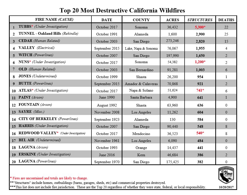
Four of the recent wildfires in Northern California are tentatively in the list of the top 20 fires in California, as ranked by structures destroyed. The exact numbers will probably change in the coming weeks as the post-fire surveys conclude.
“Structures” includes ALL structures — homes, commercial buildings, sheds, garages, and barns.
There is no doubt that after numerous wildfires started Sunday night October 8 north of San Francisco the very strong winds caused them to spread so rapidly that there is no way firefighters could put them out before they grew large. There are reports that the Tubbs Fire between Santa Rosa and Napa burned about 20,000 acres in a few hours.
Many power lines blew down or sparked as electrical conductors brushed together in Sonoma and Napa Counties.
Emergency dispatchers in Sonoma County received multiple calls of power lines falling down and electrical transformers exploding. In all, according to a review of emergency radio traffic by the Bay Area News Group, Sonoma County dispatchers sent out fire crews to at least 10 different locations across the county over a 90-minute period starting at 9:22 pm to respond to 911 calls and other reports of sparking wires and problems with the county’s electrical system amid high winds.
Officials have not released the causes of most of the fires, but the stock price of Pacific Gas and Electric which supplies electrical power to much of the area dropped 22 percent last week.
Stock price of PG&E, last two years. CNBC graphic.
On Monday the Cliff Mass Weather and Climate Blog, an excellent source for in-depth analysis of weather events, looked at the conditions that led to the extreme winds when the fires started. Here is an excerpt:
…Although there have been a lot of media reports about windy conditions, few have described the extreme, often unprecedented, nature of the winds on Sunday night and Monday morning (October 8/9th). Some have even mocked PG&Es claims of hurricane-force winds, suggesting wind speeds of 30-40 mph.
Let’s clarify a few things. There was a wide range of winds that night, with the strongest winds on ridge tops and on the upper lee slopes of terrain. Some winds was startling.
For example, at 10:30 PM on 9 Oct 2017 the wind gusted to 96 mph on a 3400 foot peak NE of Geyersville, about 20 miles NNW of downtown Santa Rosa. They reported sustained 74 knots (85 mph). Those are hurricane force winds (sustained of 64 knots or more).
At the Santa Rosa RAWS station (U.S Forest Service and Bureau of Land Management) at 576 ft elevation, the wind accelerated rapidly Sunday night to 68 mph.
Desert Research Institute’s forecast model (WRF) at very high resolution (2-km grid spacing). This is their 6-hour forecast for sustained surface winds at 11 PM Sunday October 8. Click to enlarge.
San Diego Gas and Electric (SDG&E) is still battling over who will pay for the destruction, the company or their customers, caused by the Witch Creek, Guejito, and Rice Canyon fires in 2007 that started from issues with their power lines. The fires destroyed more than 1,300 homes in southern California, killed two people, and caused massive evacuations. The Witch Creek Fire alone, which started near Santa Ysabel, burned 197,990 acres.
An engine crew from the Berkeley Fire Department shot video as they arrived at the Tubbs Fire which had already burned into Santa Rosa destroying hundreds of homes. They were part of a five-engine strike team that had been told to stage at a K-Mart parking lot but when they arrived the store was engulfed in flames.
Thanks and a tip of the hat go out to David. Typos or errors, report them HERE.
On October 14 fire photographer Jeff Zimmerman wrote about what he had seen after spending time on the wildfires in Northern and Southern California. These photos were taken by him.
By Jeff Zimmerman
I would not have believed it if I had not seen it for myself, nearly 5,700 homes destroyed, 34 fatalities, dozens of commercial buildings destroyed in a multi-day wind driven inferno pushed by hot dry diablo winds in the scenic Northern California bay area. Dry offshore winds compressed by the narrow canyons rushed down into Santa Rosa at well over 60 mph, sending swirling fire brands for great distances into residential areas, not normally prone to wildfires, just two miles north of town center. In the upper canyon along Tubbs Road in the timber and brush I could clearly see that a downed power line may have sparked a wildfire fire at night in the winds, but in the City of Santa Rosa which sustained massive structural loss to this intensity it was hard to believe.The Tubbs Fire raced down Potter Creek Road with alarming rates of spread, within a few hours firefighters estimated the fire at 20,000 acres.
Photo by Jeff Zimmerman
The Coffey Park area just east of the 101 freeway in the City of Santa Rosa, a homey housing tract of single family dwellings is wiped off the map; the Journeys End Mobile Home Park destroyed, Santa Rosa seemingly to take the direct brunt of the LNU fire complex. To the north, Mendocino was hard hit with a family losing their teenage son in the driveway as the mother had to have her legs amputated from running through the fire to escape. How do you ever survive something that horrible? It will be singed in the survivor’s minds forever.
People have underestimated the power of wildfires for years, it won’t happen to me is the mindset of many.They argue about prescribed burning and air pollution, brush removal destroys habitat, logging is unsightly, the list goes on and on. It takes a massive disaster to get things done unfortunately, better building codes, better water systems, wider roads, fire sprinkler ordinances, better brush clearance is needed; the blue – ribbon panels reports have already explained this after other massive fires in California foothill communities.
Northern California is still in flames, Calistoga, Geyserville, Napa, Sonoma, Mendocino, Nevada and Butte Counties all have fires, over 160,000 acres, with fatality lists growing by the day, possibly as many 5,700 homes destroyed, 75 cell towers destroyed, and scores upon scores of cars on scores of incinerated streets.Loved ones missing, their dreams, property and many souls never to return; all destroyed in minutes. It is hard to wrap your mind around it; to examine it is difficult at best, to live through it, terrifying.
Photo by Jeff Zimmerman
A burning wheel chair curb-side set the tragic tone, burnt cars trapped behind downed power poles with car doors flung in the open position still smoldering, roofs on top of hillside homes still burning several days after the main blaze roared through town. A disaster for learning most certainly, but the lessons will come hard. It will take years for families to negotiate with insurance adjusters, to get architectural drawings, negotiate with contractors, get water, sewer and power lines back, some may never try to rebuild at all. For those families who lost everything it will be hard to sift through the debris before having their lots cleared. Many lessons can be learned from the Oakland Hills fire, they will need to have extreme patience. The scars in their minds will never go away, even once their homes are rebuilt, you just don’t forget a fire like this. It will be hard to rise like the phoenix amidst the ash pits of total destruction.
Nighttime fires under sinister diablo winds, very short notification if any to evacuate.People burned alive in their driveways and furiously burning homes as fires with explosive rates of spread devoured everything in their path.At least 12 large wind driven urban interface fires have caused 20,000 people to flee in the dark of night as scores of homes were razed to the ground. Live- stock, pets, wildlife all killed in the flames. Wineries in the foothills destroyed, hospitals with critical patients evacuated in amongst the flames. All too much for the mind to fathom at one time in just a few days.
To the south, Santa Ana winds pushed fires into Orange County neighborhoods on October 9-10 along the 91 and 241 freeways. The fire jumped the 241 Toll Road and ran directly into hillside homes on the bluffs that overlook the valley.A fire that destroyed 24 homes in an hour right before my very eyes. By nightfall the winds subside and the Canyon 2 Fire slowed to a crawl.Swirling smoke, fire whirls, ember cast, with fire leap frogging from canyon to canyon. Unbelievable rates of spread and long range spotting, just another day covering spot news.
Setting down the camera on several occasions and picking up garden hoses to extinguish hundreds of spot fires, training police officers on site how to tackle incipient blazes to keep homes from burning, a day to remember.
The fire weather forecast as of this quick writing calls for more Santa Ana winds in Southern California, and diablo winds in Northern California putting the entire State into Red Flag Warning.I thought I would share some of my thoughts and images from Santa Rosa with you all. We are not out of the woods by any stretch of the imagination. Strikes teams of fire equipment are moving up and down the State in order to prepare for the worst. Get ready, Get set, Go! Words to live by today.
Photo by Jeff Zimmerman
Jeff Zimmerman photographs fires and writes about them, usually from Southern California.