3-D map showing the location of the Shelter Pass Fire in the Hogup Mountains west of Great Salt Lake, at 2:24 a.m. MDT August 7, 2019.
(Originally published at 3 p.m. MDT August 7, 2019)
The Shelter Pass Fire, believed to have started from lightning on Sunday, was very active Wednesday, attracting the attention at various times of two DC-10 Very Large Air Tankers, T-910 and T-911, flying out of Pocatallo, Idaho. The blaze is west of the north end of Great Salt Lake and 77 miles northwest of Salt Lake City. (see map)
The strategy is to fully suppress the fire, but with only 6 engines, 1 helicopter, and no hand crews assigned as of Tuesday night, that will be difficult until forces arrive in much greater numbers.
Wednesday afternoon the Great Basin Coordination Center said the fire had burned 8,500 acres, an increase of 7,900 acres over the size reported Tuesday evening.
As this is written at 3 p.m. MDT Wednesday, Tanker 910, a DC-10, is maneuvering over the Shelter Pass Fire preparing to drop about 9,000 gallons of fire retardant.
Map showing the location of the Shelter Pass Fire in the Hogup Mountains west of Great Salt Lake, at 2:24 a.m. MDT August 7, 2019.File photo of three DC-10 Air Tankers at Albuquerque, May 3, 2019: Tankers 910, 911, and 914. Photo by Bill Gabbert.
The Alaska Fire was 450 acres at 1 p.m. Wednesday, July 31, 2019
A Neptune Aviation BAe-146 drops on the Alaska Fire, July 31, 2019. Photo by Jocelyn Marie Cooley.
(Originally published at 1:29 p.m. MDT July 31, 2019)
It was just two weeks ago that the Round Peak Fire was ignited by a campfire at 9:30 p.m. July 15 in the hills above Springville, Utah south of Provo. A new fire, the Alaska Fire, was reported at 11:30 p.m. on July 30th near Alaska Avenue, northeast of Springville. The cause is under investigation but there was no lightning in the area.
Wednesday at 1 p.m. MDT fire authorities said it had burned approximately 450 acres and was still moving uphill in grass and brush. A type 3 Incident Management Team will assume command of the incident today. Crews will concentrate on building fireline while supported by aircraft as needed.
The Alaska Fire, July 31, 2019. Photo by Jocelyn Marie Cooley.
These photos, used with permission, were taken just before noon MDT July 31 with a long lens by professional photographer Jocelyn Marie Cooley, from her home in the Springville area. We also used one of her shots when we covered the Round Peak Fire. Thank you Jocelyn!
A Neptune Aviation BAe-146 maneuvers over the Alaska Fire, July 31, 2019. Photo by Jocelyn Marie Cooley.A Single Engine Air Tanker and a Neptune Aviation BAe-146 maneuver over the Alaska Fire, July 31, 2019. Photo by Jocelyn Marie Cooley.
A wildfire just east of Springville, Utah (see the map below) burned 167 acres before it was stopped by firefighters yesterday. At Wildfire Today we don’t often devote an article to a fire this size, but the Round Peak Fire is notable in two ways. One, that the U.S. Forest Service employed a different strategy from what they used last summer on the Bald Mountain and Pole Creek Fires about 8 miles to the south. Those fires were initially managed to accomplish resource management objectives. In other words, they were not suppressed, just herded around. As the Uinta-Wasatch-Cache National Forest inadequately considered fuel moistures, drought, and the weather forecast, the two fires merged and burned over 120,000 acres forcing evacuations of communities.
But the Round Peak fire, ignited by a campfire at 9:30 p.m. July 15, was suppressed. The resources the Forest Service used included 4 hand crews, 2 helicopters, 4 Single Engine Air Tankers, 1 large air tanker (MD-87), and 1 Very Large Air Tanker (DC-10).
In the video below it is difficult to determine what type of fixed wing aircraft it is, but it appears to be a DC-10, especially considering the length of the drop.
In addition to the Forest Service aggressively attacking this new fire, another reason we are writing about this fire is that numerous photos of the fire are available, supplied by Utah Fire Info and the Uinta-Wasatch-Cache National Forest.
Map showing the location of the Round Peak Fire east of Springville, Utah. Wildfire Today.A DC-10 drops through the smoke on the Round Peak Fire east of Springville, Utah.An MD-87 drops on the Round Peak Fire east of Springville, Utah. Photo by Jocelyn Marie Cooley.A Single Engine Air Tanker drops on the Round Peak Fire east of Springville, Utah.A helicopter with a water bucket maneuvers over the Round Fire east of Springville, Utah. Two Single Engine Air Tankers are in the background..A DC-10 drops on the Round Peak Fire east of Springville, Utah.
Bald Mountain and Pole Creek Fires south of Provo in 2018
Pole Creek-Bald Mountain Fires. Photo from the report.
The Bald Mountain and Pole Creek Fires started last year on August 24 and September 6 respectively about 15 miles south of Provo, Utah in the Uinta-Wasatch-Cache National Forest. Both fires were initially managed in a less than full suppression mode — allowed to spread within lines drawn on a map. Rainfall amounts ranging from 1.3″ to 2.3″ on August 25 put a damper on the fire activity, but within days the Energy Release Component had returned to the 90+ percentile range. Meanwhile the area had been classified as in Severe Drought by the Drought Monitor.
The weather changed on September 10, bringing strong winds and a series of Red Flag Warnings causing the two fires to burn together. The final size was 120,851 acres.
Map of the Pole Creek – Bald Mountain Fire. Wildfire Today
The Bald Mountain Fire caused mandatory evacuation of two cities: Elk Ridge and Woodland Hills. The Pole Creek Fire triggered mandatory evacuations for the Covered Bridge Community of the Spanish Fork Canyon along with the Diamond Fork Canyon and the Right Fork Hobble Creek Canyon areas.
Late afternoon on August 24, the District Ranger wrote a Wildland Fire Decision Support System (WFDSS) decision for the Bald Mountain Fire, which was then at 0.1 acre in size. This decision was published on August 27 at 1018 hours. Based on map estimates, the planning area boundary was 3,280 acres.
The relative risk was determined to be low, as were the probability of a significant event or extreme fire conditions. A Type 4 organization was determined as appropriate for staffing. The course of action recorded in WFDSS was to: “Allow fire to burn to north, northeast and east. However, consider and allow suppression actions on the southwest and southern boundaries to prevent fire from reaching private lands and minimizing the need to close the Mona Pole Road. Fire behavior may dictate a different outcome, but where management of the fire through suppression or other tactics allow for steering the fire in the right direction, implement those.”
[…]
Fire managers assessed the opportunity to take advantage of this fire to meet restoration objectives by taking into account such factors as: a lack of values at risk (campgrounds, private inholdings, power lines, etc.), the composition of the surrounding vegetation, time of year, remote location, recent precipitation, and potential hazards (standing dead trees, steep terrain, and loose rocks). They expected the fire to go out by itself like other recent fires on the Forest.
“We put the Bald Mountain Fire into monitor status due to issues with snags and associated safety concerns, but also because it was Wilderness where fire is OK as a natural process,” said the Zone Assistant Fire Management Officer/Duty Officer (ZAFMO/DO). “But firefighter safety was the primary driver for our decision.”
[…]
September 10
Shortly after 1400 hours, ICT4 called Dispatch, informing them that the winds had increased and the fire had aligned with the south fork of the drainage and was making a run. He requested that they order a Type 2 Incident Management Team (IMT) and multiple aviation resources. ICT4 was new to the Region but came from a high complexity forest with a heavy fire load. Where he was from, an order for a Type 2 Team and significant aviation resources would have been automatic.
Meanwhile, ZFMO had just left the fire an hour before, when it was still 25 acres. “When I hit the bottom of Nebo Loop [Road] I could hear clearly a Type 2 Team being ordered from the fire,” said ZFMO/DO, a long-time UWF employee who had also been a hotshot superintendent on a northern Utah crew. He thought, “We need to ‘pump the brakes’ on the team order.” He told ICT4, (also a qualified ICT3) to hold on until he could get a look at the fire.
At the time ICT4 was calling for a Type 2 Team, the Forest DO and Forest FMO were briefing the Forest Supervisor. Not knowing the details of the rapidly evolving situation and thinking the fire was approximately 75 acres, the Forest Supervisor asked the Forest DO to put a hold on the aircraft and Type 2 IMT. After the Forest Supervisor’s review of WFDSS, it didn’t make sense to take such aggressive suppression action. The fire was well within the planning area, meeting objectives, and not close to threatening values at risk (see Figure 13). Parts of the order for aircraft went through, however, and shortly thereafter a Type 1 Helicopter and some “Fire Bosses” (water-scooping single-engine air tankers) were on scene.
[…]
September 13
[…] At 0836, the Forest Supervisor canceled the Type 2 IMT and ordered a Type 1 IMT to assume command for both the Pole Creek and the Bald Mountain Fires. At 1030, ZFMO flew the fires with ICT3 and ICT3t. The flight was rough due to unstable air and high winds. Both fires were actively burning and had already formed columns. They witnessed extreme fire behavior along the Highway 89 corridor with ongoing firefighting efforts. ICT3 noted that the Pole Creek Fire would likely impact Highway 6. ZFMO contacted Forest DO and recommended that the Forest Supervisor order a second Type 1 Team for just the Bald Mountain Fire due to fire behavior, values at risk, and the complexities of both fires.
September 13: Bald Mountain IC Transitions
At approximately 0500, a local Fire Chief arrived on scene and tied-in with Bald Mountain IC. The Chief ordered three engines from his department. All resources on the Bald Mountain Fire were now engaged in evacuations.
[…]
The WFDSS for Pole Creek published on September 13 included these courses of action:
Only commit firefighters under conditions where firefighters can actually succeed in protecting identified values at risk.
Utilize direct and indirect tactics to fully suppress the fire. This action will take into account: first, risk and exposure to firefighters and the public; and second, the protection of identified values such as utility corridors and infrastructure, private structures, the railroad corridor, and the Highway 6 corridor.
The WFDSS for Bald Mountain published on September 13 included the previous courses of action for Pole Creek and added:
Assign a Public Information Officer in order to disseminate timely information to the public, partners, and cooperators, including local government and law enforcement. All closures and evacuations will be coordinated with the Utah County Sheriffs’ Office.
Agency Administrator approval is required prior to any mechanized tool use within the Nebo Wilderness Area. Outside the Wilderness, the full range of tools and tactics are authorized. Work with READ [Resource Advisor] to mitigate impacts and assess rehab needs
[…]
Lessons Learned by Participants of the Incidents
Preparedness
Reading the 7-10 day outlook along with the spot weather forecasts can assist in gaining a better long-term perspective, which may lead to making different decisions in long-term events.
Using the 10 risk questions in WFDSS can open our thinking to options we may not have considered. These questions could encourage us to more carefully consider a wider array of possible outcomes from the decisions we make.
Fire modelers and weather forecasters are able to make better predictions with accurate and timely field observations.
Collaboration with predictive services early in an incident around long-term outlooks may help fire decision-makers. They are constantly producing tools to help firefighters in the field.
“Normalization of deviance2” (also referred to as “practical drift”) led us to not consider the worst-case scenario. Without planning for the worst-case scenario, we are constantly behind the power curve.
Operations
Nighttime fire behavior surprised us, especially this late in the season. This experience showed that high winds can override cooler temperatures and still create extreme fire behavior late in the fire season.
Understanding the capability and capacity of your resources is critical to ensuring the probability of keeping your resources safe.
The fire burned 75 acres near Bountiful, Utah in 2017
Bountiful Fire, August 29, 2017, near Bountiful, Utah. Screenshot from KSL 5 TV video.
A man has agreed to pay $395,914 in a settlement for suppression and other costs associated with the 75-acre Bountiful Fire that started August 29, 2017 near Bountiful, Utah.
The fire ignited on Jayson Ross Orvis’ Bountiful Bench Hillside Hollow Circle property and quickly spread to the adjacent Uinta-Wasatch-Cache National Forest. It was caused by sparks from a power grinder used by James Golden, who was hired by Mr. Orvis to do work on his property.
The settlement includes a $14,123 payment for environmental remediation costs associated with multiple encroachments on U.S. Forest Service property in addition to the fire damage. Additionally, Mr. Orvis has forfeited $560 for two Forest Service violations that prohibit constructing, placing and maintaining structures without a permit on national forest land. During the fire investigation, it was determined that Mr. Orvis had placed a shooting pavilion and an outfitter tent on the national forest land.
“This settlement fully compensates the public for the expense of fighting the fire and restoring these public lands,” U.S. Attorney John W. Huber said today.
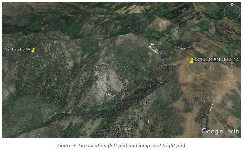
The Wildland Fire Lessons Learned Center has released a Facilitated Learning Analysis for an incident within an incident. Three of the seven smokejumpers that parachuted into the Miner Camp Peak Fire on July 29 east of Meadow, Utah were injured when landing. (Map) Two injuries were to the hand or wrist and the other was diagnosed at the scene as a broken collar bone or at least the potential for one.
The jumpers were evacuated by two helicopters, an air ambulance and a helicopter with hoist capabilities.
The jumpers received the resource order for the fire at 8:30 a.m. on July 29 while they were engaged in physical training at Winnemucca, Nevada. Since some of them “like to run trails in the surrounding area”, they did not get off the ground until 10:30. Due to the delayed departure, the distance they had to fly, and multiple issues related to fuel, the seven jumpers did not arrive on the ground at the fire until 5 p.m.