Shots fired toward firefighters in Washington state

Four firefighters felt they were targeted, including two from Australia

(This article was updated at 6:13 p.m. PDT September 10 after more information became available.)

Four firefighters said they were shot at while working on a fire in Washington State last month. Two of the firefighters were with the group of 80 that came over from Australia in early August to help suppress wildfires in the United States.

The incident occurred August 23 on the Miriam Fire near the White Pass Ski Area west of Rimrock Lake about 40 air miles west of Yakima, Washington in the Okanogan-Wenatchee National Forest. The Miriam Fire is adjacent to the ski area.

A Rapid Lesson Sharing (RLS) report was posted at the Wildland Fire Lessons Learned Center on September 7, 2018. It explains that two lookouts were talking with two of the Australian firefighters, one of which was a Division Supervisor and the other was a Safety Officer. They saw two people walking on the Pacific Crest Trail about 200 yards below them. Excerpts from the RLS document will take it from here:

…The incident personnel stand up and holler and wave. All four are wearing yellow Nomex fire shirts. Two had bright yellow hardhats. They therefore thought they had been seen by these two individuals.

The incident personnel watched with binoculars as one of the two individuals put a scoped rifle on a bi-pod and looked up the mountain toward them. They continued to wave until a shot was fired. They then bailed off the backside of the mountain to take cover as a second shot rang out.

DIVS A/C notified Communications of the rifle shots and told them to notify the two Lookouts on DP 10 about what happened and tell them to leave the area. The shooter and companion started to walk north on the PCT. The four incident personnel could no longer see them but heard several more shots coming from the direction that they had gone. The four bailed off the ridge, ran to the PCT, and went to Helispot H-4 for a helicopter ride out of the area.

At approximately 1510, the Incident Management Team (IMT) initiated the Incident Emergency Plan (an Incident within an Incident-IWI). The Deputy Incident Commander, Air Operations Branch Director, and Safety Officer went to the Communications Unit.

At that time, the following actions took place:

  • Divisions A and C were evacuated.
  • The Sheriff was notified.
  • The IMT’s Law Enforcement Officers (LEO) were responding to area, as well as the Field Operations Section Chief.
  • Helicopters were put on standby for evacuating the four incident personnel from H-4.
  • The ICP was locked down and supervisors were ordered to account for their personnel.
  • The Incident Commander and Agency Administrator were giving briefings (of what they knew) periodically to ICP/Camp personnel.
  • The Sheriff’s Deputies found the rifle shooting individuals’ vehicle on Highway 12 and ran the license plates. They were then able to locate people who knew them and confirmed that they had gone bear hunting near the ski area. The Sheriff’s Deputies then made contact with them.
  • They were cited for entering a closed area—with additional charges pending.

At 1730, the IWI was terminated. Personnel resumed their normal fire management and support duties.

Traci Weaver, a Public Affairs Officer for the Pacific Northwest Regional Office said a press release was issued the day after the incident. Apparently it did not get a great deal of attention at the time.

We checked, and this was in the middle of a long paragraph that talked about closures, resources, location, cause, and more:

…Yesterday, two people entered the Area Closure and fired rifles in the direction of our firefighters. This caused fire operations to halt in the ski area and that section of fireline to be evacuated until the situation could be resolved…

George Jacobs, a spokesperson for the U.S. Attorney’s Office in Spokane said he understood that the two shooters were issued Violation Notices by the U.S. Forest Service. The charge was for being in an area that was closed by the Forest Service. The agency routinely issues Orders temporarily closing areas that are affected by large fires.
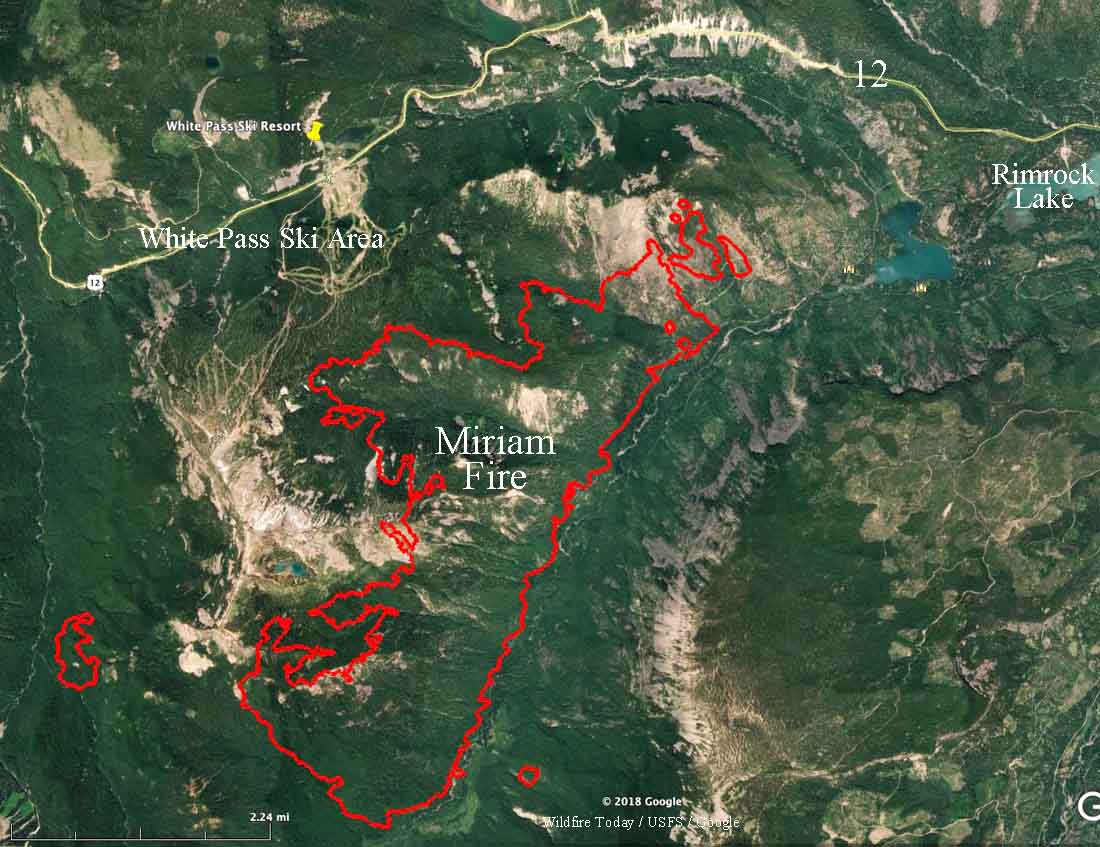
White Pass Ski area Miriam fire
Map showing the Miriam Fire (the red line) and the White Pass Ski area, about 40 air miles west of Yakima, Washington. Click to enlarge.

Thanks and a tip of the hat go out to Tom.
Typos or errors, report them HERE.

Firefighters meet at international border

The Horns Mountain / Santa Rosa Fire is burning in Washington and British Columbia

border canada united states firefighters horns mountain
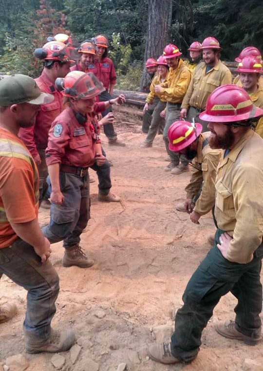
Firefighters meet at the Canada / United States border while working on the Horns Mountain Fire. Canadians on the left and Americans on the right. Photo by Johnny Walker.

(Originally published at 4:15 p.m PDT August 28, 2018)

The 5,500-acre Horns Mountain Fire is burning in both Canada and the United States — Washington and British Columbia — east of  the Laurier Port of Entry border crossing. In Canada the fire is named Santa Rosa.

In the photo above firefighters from both countries had a good natured meeting at the international border. I would wager that the topics discussed did not include tariffs or trade agreements.

Due to numerous large fires in Washington and British Columbia, both sides experienced a shortage of resources. According to an update from the incident management team, “working together was a benefit to both”.

The fire is winding down thanks in part to favorable weather in the last few days. Some resources on both sides are being demobilized.

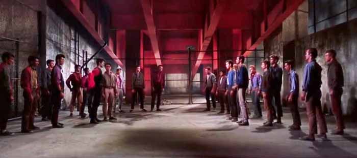
UPDATE: August 29, 2018: When we posted this on our Facebook page Eric Haberin wrote, “Very much West Side Story”. I found the fight scene on YouTube and got a screenshot:

fight scene in West Side Story
The Jets face off with the Sharks in West Side Story.

The big difference is that the firefighters are smiling.

Crescent Mountain Fire burns tens of thousands of acres west of Winthrop Washington

The fire is in north-central Washington 10 miles west of Winthrop

Above: The Crescent Mountain Fire on August 15, 2018. Inciweb photo.

(Originally published at 1:50 p.m. PDT August 24, 2018)

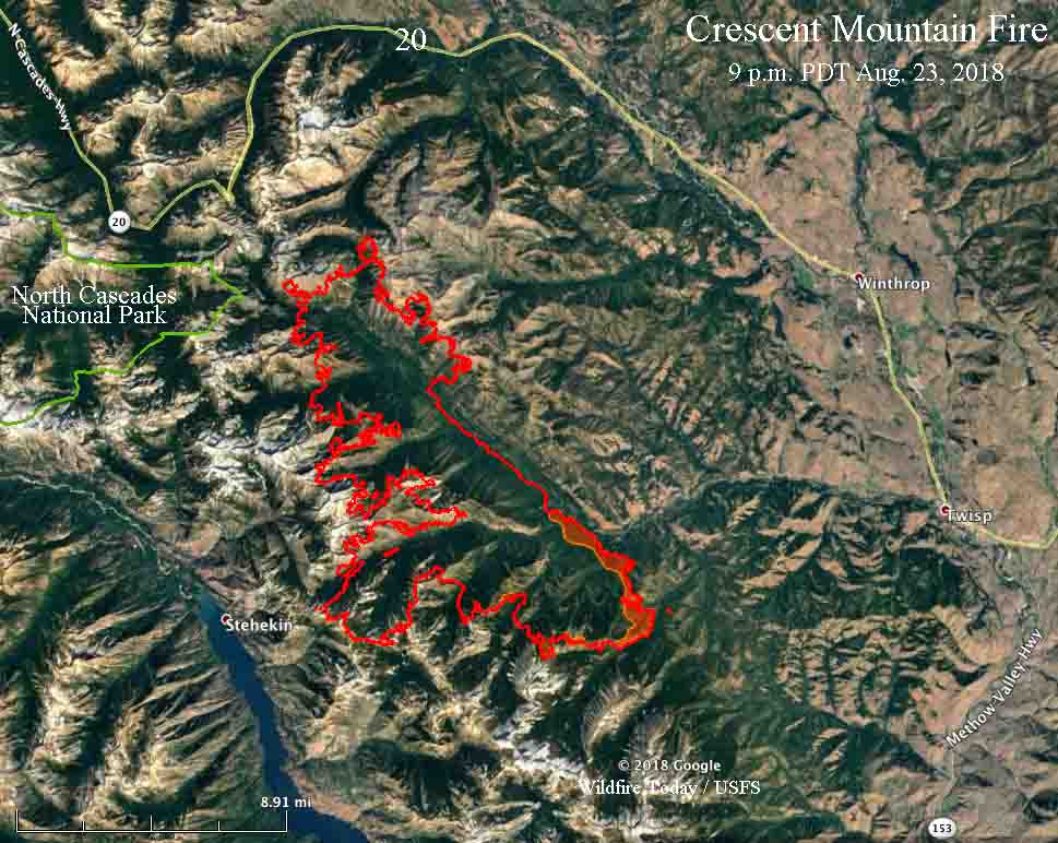
The Crescent Mountain Fire in north-central Washington has burned over 40,000 acres since a lightning strike started it on July 29. The fire is being managed at least in some areas as a less than full suppression fire. One of the primary reasons as you can see in the 3-D map below, is that the west side is burning into sparse vegetation above 7,000 feet in steep, remote, inaccessible terrain.

3-d map Crescent Mountain Fire
A 3-D map looking northwest at the Crescent Mountain Fire, the red line, at 9 p.m. PDT August 23, 2018. The red shaded areas indicate intense heat at the time the fire was mapped by a heat-sensing aircraft. Click to enlarge.

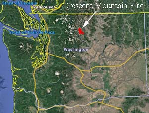
The fire is about 10.5 miles west of both Twisp and Winthrop, Washington.

map Crescent Mountain Fire
Vicinity map of the Crescent Mountain Fire in the state of Washington.

Evacuation orders are in effect for West Buttermilk Creek Road and Twisp River Road, west of the Buttermilk Creek intersection.

Northwest winds on Thursday caused the fire to be very active. The area with the greatest growth was on the south slope above the Twisp River on both sides of Scaffold Canyon and up to Scaffold Ridge. It has burned down to the West Fork of Buttermilk Creek.

Firefighters provided structural protection and assistance to homes along the Twisp River corridor throughout the day Thursday. Air operations were able to effectively slow the advance of the fire.

On the southwest side crews continue to monitor the fire within North Cascades National Park. Most of the fire is on land administered by the U.S. Forest Service.

map Crescent Mountain Fire
The red line on the map was the perimeter of the Crescent Mountain Fire at 9 p.m. PDT August 23, 2018. The red shaded areas indicate intense heat at the time the fire was mapped by a heat-sensing aircraft. Click to enlarge.

Wildfire activity increases in Washington

The state has 18 wildfires with varying levels of evacuations in effect

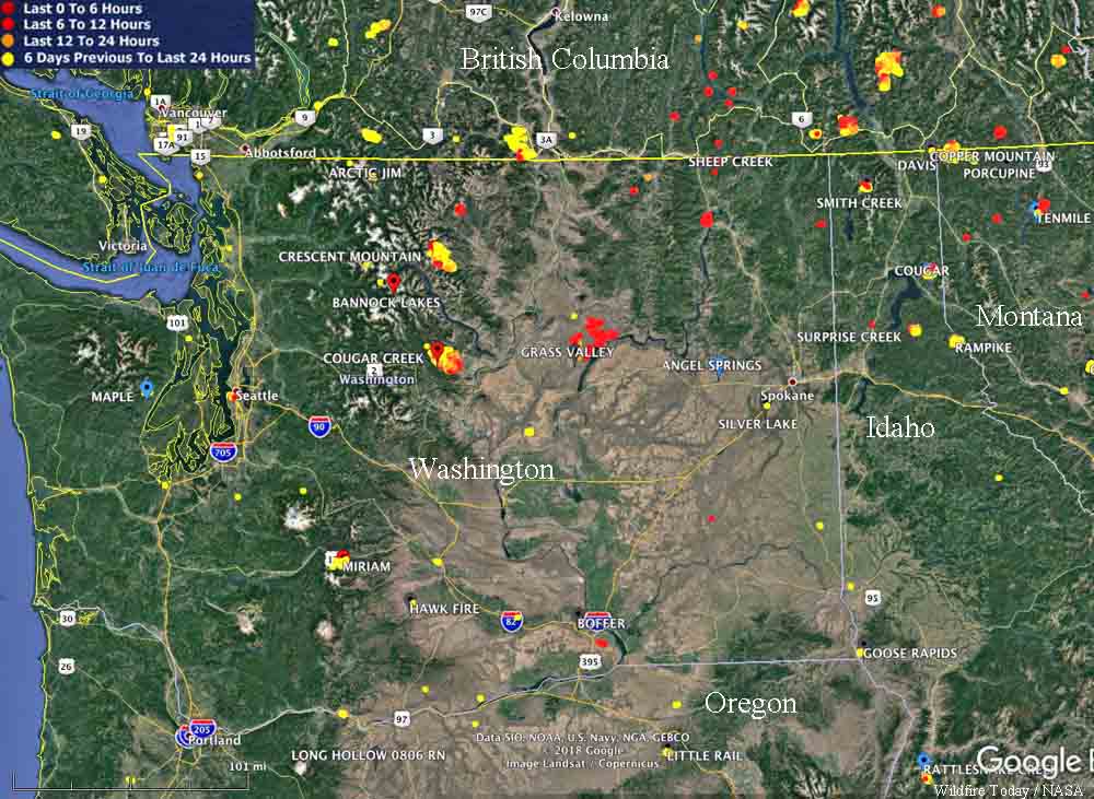
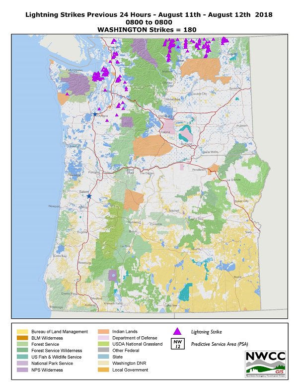
Firefighters in Washington state have been very busy recently, especially Saturday when 68 new fires were detected, primarily in the eastern part of the state. Abundant lightning accompanied by strong winds and very dry fuels created critical fire conditions.

They currently have 18 fires with varying levels of evacuations in effect.

map large wildfires Washington
Map showing some of the large wildfires in Washington, August 12, 2018. Click to enlarge.

One of the largest is the 45,000-acre Grass Valley Fire that started August 11 west of Grand Coulee Dam. Firefighters report extreme fire behavior with running and spotting. Evacuations and road closures are in effect.

The Cougar Creek Fire has burned 18,890 acres 25 mi west of Chelan, WA. The fire is exhibiting extreme fire behavior. Evacuations are in effect.

The 15,975-acre Crescent Mountain Fire is 16 miles west of Winthrop, WA.

lighting strikes August 11, 2018

Boylston Fire in Washington grows to 70,000 acres overnight

On Friday the eastbound lanes of Interstate 90 were closed

Above: Photo of the Boylston Fire taken by the Washington DNR Ahtanum crew when they were evacuating the Wanapum recreational area Thursday night.

(Originally published at 10:08 a.m. PDT July 20, 2018)

A very rapidly spreading wildfire in Washington forced the closure Friday of the eastbound lanes of Interstate 90 east of Kittitas in the area of milepost 122. The Boylston Fire was reported late in the afternoon Thursday July 19 and by 10 a.m. Friday fire officials estimated it had grown to 70,000 acres.

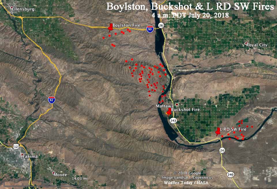
The fire is burning mostly south of Interstate 90 between Ellensburg and Mattawa. It apparently started near the Interstate and spread southeast about 13 miles to the Columbia River.

map Boylston Fire Washington
The red dots represent heat on the Boylston, L RD SW, and Buckshot Fires detected by a satellite at 4 a.m. PDT July 20, 2018. It is likely that in some areas with light fuels, such as grass, the fire could have burned and cooled in between satellite overflights, and therefore was not detected in those areas. Click to enlarge.

Some areas on the Boylston Fire are difficult for ground crews to access.

A Type 2 Incident Management Team is en route.

The Red Flag Warning for the area on Friday will not give firefighters a break. The forecast calls for relative humidity of 12 to 25 percent and winds out of the west at 10 to 20 mph gusting to 25.

Red Flag Warning, July 20, 2018
Red Flag Warning, July 20, 2018.

There are two other smaller fires in the same general area, southeast of the Boylston Fire. The Buckshot Fire is on the east side of the Columbia River southwest of Mattawa. A fire with an unfortunate name, the “L RD SW Fire” is farther east near the intersection of Highways 24 and 243, and is also near the river.

These three fires are 27 to 36 miles northeast of Yakima, Washington.

Regarding the Tweet below, at 10 a.m. PDT Friday, fire officials estimated the Boylston Fire had burned 70,000 acres.

Milepost 22 Fire threatens homes in Central Washington

The fire is near the Columbia River 19 miles east of Ellensburg

Above: The Milepost 22 Fire, Wednesday night. Photo by Washington State DNR.

(UPDATED at 10:53 a.m. PDT June 21, 2018)

The Washington State DNR announced at about 10 a.m. Friday that the Milepost 22 fire has burned approximately 4,000 to 5,000 acres.

****

(Originally published at 7:32 a.m. PDT June 21, 2018)

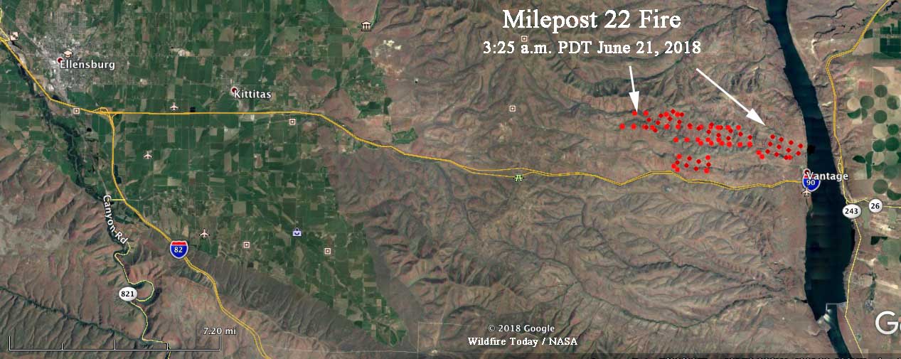
A fire that started late Wednesday afternoon is threatening homes in Central Washington. The Milepost 22 Fire was first reported about two miles north of Interstate 90. Since then it has burned at least 1,750 acres, according to the Washington State Department of Natural Resources.

The blaze is just west of Wanapum Lake on the Columbia River at Vantage, Washington and is on both sides of the Vantage Highway which is parallel to and north of Interstate 90. The highway was closed Wednesday afternoon due to downed power lines, but the Interstate remained open.

map Milepost 22 Fire
Map showing heat detected on the Milepost 22 Fire by a satellite at 3:25 a.m. PDT June 21, 2018. Click to enlarge.

Thursday morning the DNR reported that the fire was still growing. A Type 3 Incident Management Team will assume command of the fire at 6 a.m. Thursday.

The weather forecast for the fire area Thursday calls for temperature in the mid-80s, relative humidity in the low 30’s, and wind out of the northwest at 11 to 18 mph gusting at 18-25.

Milepost 22 Fire
The Milepost 22 Fire, Wednesday night. Photo by Washington State DNR.