The report that the U.S. Forest Service wrote about last year’s fires in the Washington and Oregon reminded me of one of the best pictures of the fires in 2015 — the one you see above. The photo is at the beginning of the “Interactive Story Journal” which provides summary information from the main report.
We first used the photo on September 6, 2015 in an article with several other images by the photographer, Kari Greer. It was taken on the First Creek Fire on the west side of Lake Chelan in Washington and as you can see it shows a rising moon as the fire backs down the slopes.
We contacted Ms. Greer who told us it was taken above the Hale place in 25 Mile Creek on August 27 as the moon was coming up. The camera was on a tripod at about 9 p.m. with a 50mm focal length at 1/80 second.
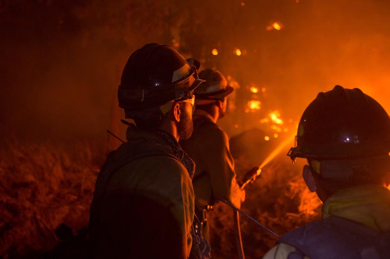
Photo above: Firefighters observe the Cougar Creek Fire southeast of Mt. Adams in southern Washington in 2015. From InciWeb.
The U.S. Forest Service has produced an exhaustive summary and review of the 2015 wildfire season in what they call their Pacific Northwest Region — what the interagency community calls the Northwest Geographic Area — Oregon and Washington.
The report is huge, 281 pages. In addition to general information about the fire activity, it includes sections about weather, air quality, technology, and summaries of 28 fires with 14 of those being covered in greater detail than the others.
The main 281-page report can be be found here (it’s a LARGE file). There is another version they call an “Interactive Story Journal” which provides summary information from the main report as well as interactive web maps, videos, and numerous photos as well as “time-enabled fire progression maps” for selected fires.
Below are some excerpts from the report:
****
Most Severe Fire Season in Modern History
The 2015 fire season in the Pacific Northwest was the most severe in modern history from a variety of standpoints. Oregon and Washington experienced more than 3,800 wildfires (almost 2,300 in Oregon and more than 1,500 in Washington) that burned more than 1,600,000 acres (more than 630,000 acres in Oregon and more than 1,000,000 acres in Washington)—including 1,325 fires representing 507,000 acres on U.S. Forest Service lands (information as of September 30, 2015).
Initial Attack was successful in rapidly containing all but about 119 of these fires. This response represents an almost 97 percent Initial Attack success rate. Approximately 50 of these fire escapes occurred during a ten-day period in mid-August when numerous Large Fires (a wildfire of 100 acres or more in timber or 300 acres or more in grass/sage) were already burning in the Pacific Northwest. During this time, the Northern Rockies and Northern California were also experiencing unusually high numbers of wildfires. This situation limited the ability to rapidly obtain Initial Attack reinforcements as well as almost all types of firefighting resources needed for Large Fires.
Firefighters conduct a firing operation to protect homes on the Chelan Complex in Washington, 2015. Photo by Kari Greer.
Tragedy Strikes
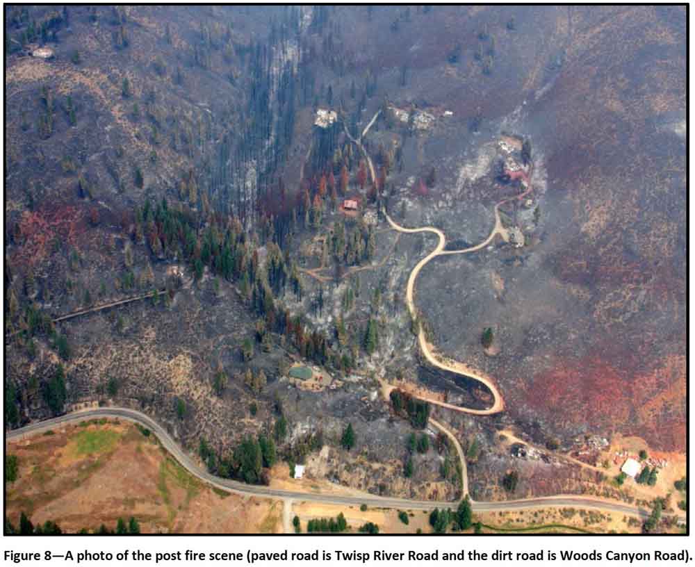
Tragedy struck on August 19 when three U.S. Forest Service firefighters were killed while attacking a fire on private land near Twisp, Washington.
During this severe fire season, approximately 675 structures were lost. While well over 16,000 structures were threatened, most were saved from loss by aggressive suppression actions.
2015 Fire Season Milestones
In August, to help support Washington State’s fires, the Emergency Support Function 4 (ESF4) was activated by the Federal Emergency Management Agency (FEMA).
The Emergency Conflagration Act—that authorizes the Oregon Office of the State Fire Marshal to mobilize structural firefighters and equipment to assist local resources battling fires—was invoked by the Governor of Oregon on July 30 in response to the Stouts Creek Fire, on August 13 for the Cornet Fire and Windy Ridge Fires, on August 14 for the Canyon Creek Fire, and on August 20 for the Grizzly Bear Complex.
The Washington State Fire Service Mobilization Plan is implemented to provide personnel, equipment, and other logistical resources from around the state when a wildland fire or other emergency exceeds the capacity of local jurisdictions. In mid-August, the Chief of the Washington State Patrol authorized such a state-declared mobilization on the Carpenter Road Fire, the Kettle Complex, and the Okanogan Complex.
The Pacific Northwest Region had the highest priority in the nation for firefighting resources during these dates: July 25 and 26, August 14-31, and September 8-13.
The Pacific Northwest Region was under a Preparedness Level 5 (the highest, most severe level) from August 13 through September 4.
The greatest number of uncontained fires occurred on August 18: 25 Large Fires totaling 822,512 acres in the Pacific Northwest Region (105 Large Fires totaling 2.2 million acres nationally).
Weather
The first six months of 2015 were the warmest first six months of any year over much of Oregon and Washington since record keeping began in 1895.
These record-warm temperatures observed during the winter and spring, coupled with below-average precipitation, led to an exceptionally poor snowpack throughout the winter and spring.
From June 1 through September 15, a total of 51,019 lightning strikes were recorded over Oregon and Washington. The average for fire seasons from 2000-2014 through September 15 is 78,775 strikes. While the number of the 2015 strikes was below this average, the background of drought in 2015 enhanced the ability for lightning strikes to ignite multiple fires in short periods of time.
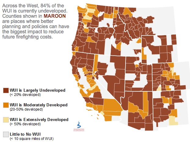
Headquarters Economics released a report about how five cities have used innovative land use planning techniques as a way to adapt to the growing threat from wildfires. The authors met with city planners, elected officials, and firefighters in Austin, Texas; Boulder, Colorado; Flagstaff, Arizona; San Diego, California; and Santa Fe, New Mexico—all communities with a recent history of wildfire and a reputation for being problem solvers.
Headwaters Economics
Prescribed fire escapes in Florida
In St. Johns County, Florida on Tuesday a prescribed fire intended to treat 140 acres off County Road 208 escaped control when an unexpected 20-25 mph wind gust scattered burning embers. About 270 acres later the Florida Forest Service was able to contain the blaze.
Spokesperson Julie Maddux said statewide in 2015 the Florida Forest Service burned more than 236,000 acres during prescribed fires and none of them got out of control.
U.S. Forest Service releases findings on the effects of drought for forests and rangelands
“Our forests and rangelands are national treasures, and because they are threatened, we are threatened,” said Agriculture Secretary Tom Vilsack. “This report confirms what we are seeing, that every region of the country is impacted by the direct and indirect effects of drought conditions and volatile weather patterns. Sixty million Americans rely on drinking water that originates on our 193 million acres of national forest and grasslands. They support 200,000 jobs and contribute over $13 billion to local economies every year.”
Utah seeks jail time for drone operators that interfere with wildfire operations
Last year there were numerous instances across the West of drones flying into the airspace above active fires and interfering with the operations of firefighting aircraft.
From the AP:
..A new proposal in the Utah Legislature aims to address the growing problem by creating a possible penalty of jail time for people who fly drones within 3 miles of a wildfire.
A House committee was scheduled to discuss the proposal Tuesday afternoon but the hearing was postponed.
Republican Rep. Kraig Powell of Heber City, the proposal’s sponsor, said he asked to postpone the meeting so he could get more input from interested parties. He said he may add exemptions for certain entities, such as public utility companies that need to use drones to see if the fire will impact gas lines.
Jason Curry of the Utah Division of Forestry said he hopes lawmakers back the bill…
“I really hope it doesn’t take a major mishap and somebody to lose their life for the public to take it seriously,” Curry said.
Washington state treats less land with prescribed fire than their neighbors
Washington lags far behind neighboring states in using controlled burns to thin out dangerously overgrown woodlands.
After back-to-back years of catastrophic forest fires, some state lawmakers want that to change.
“I’ve had it. I think it is time to delve into the policy,” said state Sen. Linda Evans Parlette, R-Wenatchee, who represents a large swath of North Central Washington scorched in last year’s record-setting fires that burned more than 1 million acres.
Parlette is sponsoring a pair of “fight fire with fire” bills that would require more controlled burns on state lands and loosen smoke regulations to make it easier for federal and private land managers to conduct burns.
Experts say expanding the use of controlled burns is vital to restoring forests to health, leaving them less vulnerable to massive blazes when the summer fire season hits.
But some U.S. Forest Service officials and other critics say the state’s Department of Natural Resources (DNR), led by Commissioner of Public Lands Peter Goldmark, has discouraged controlled burns in recent years because of fears over smoke drifting into communities.
Photo above: 19 white hearses brought the Granite Mountain Hotshots back to Prescott, Arizona, July 7, 2013. They were killed after being overrun by the Yarnell Hill Fire. Photo by Bill Gabbert.
A bill introduced in the Washington state legislature would provide for state employed firefighters a system that would track their location. Knowing where firefighters are while working on a rapidly spreading fire is crucial to ensuring their safety, and is half of what we have called Holy Grail of Firefighter Safety. The other half is knowing the real time location of the fire relative to the personnel. If a Division Supervisor, Operations Section Chief, or Safety Officer is monitoring this information they could potentially warn firefighters that their present position is in danger when the fire begins to spread in their direction. A system like this might have saved 24 lives on the 2013 Yarnell Hill and 2006 Esperanza Fires. In both cases the firefighters and their supervisors did not have a clear understanding of where the fire and the firefighters were.
In a January 18 article about how to reduce the number of fatalities on wildland fires, we wrote:
When you think about it, it’s crazy that we sometimes send firefighters into a dangerous environment without knowing these two very basic things.
Below is a section from House Bill 2924 as introduced in the Washington State Legislature on January 27, 2016, sponsored by six lawmakers:
…Require all fire suppression equipment and personnel in its employ or direction to be outfitted with an electronic monitoring device that utilizes global positioning system technology to protect the safety of wildland firefighters…
The Seattle Times wrote about the proposed legislation. Here is an excerpt:
…DNR has done some early research on GPS, according to Bob Johnson, the agency’s wildfire-division manager. Setting up a system could cost $1.5 million, Johnson told lawmakers.
“Improving safety for our firefighters is paramount and we’d view this technology … as a viable supplement to existing safety measures,” wrote Mary Verner, DNR’s deputy supervisor for resource protection. “Though, it, like many technologies, does have its limitations.”
Challenges, benefits
GPS locaters are used by various departments and agencies around the country, according to Triplett.
But there aren’t yet national standards for GPS systems, so when firefighters come from different agencies or another state to fight large blazes, they may not have equipment that works together, according to Triplett.
Steve Pollock, chief regional fire coordinator for the Texas A&M Fire Service, said it took about three years to develop that agency’s GPS system. When it goes live in July, it will be able to track more than 200 bulldozers, fire engines and coordinating vehicles, he said…
There needs to be leadership, nationally, to develop standards for firefighter tracking systems so that the devices used by different agencies are compatible and interoperable. This should be the duty of the National Wildfire Coordinating Group, National Association of State Foresters, U.S. Forest Service, National Park Service, and Bureau of Land Management.
If individual state and local organizations spend millions on stand-alone systems that can’t be used outside their jurisdictions it will be FUBAR. Leadership is needed. Today.
First Creek Fire, Okanogan-Wenatchee NF, Washington, 2015; burn operation in Morning Sun Estates. Photo by Kari Greer.
Washington state’s Commissioner of Public lands has written an opinion piece making his case for increased funding for managing wildfires in the state.
…It was a grim preview of the toll wildfire would eventually take across our state in 2015: burning more than a million acres; destroying 307 homes; robbing tribal communities of timber revenue and hunting grounds; and killing three Washington firefighters who were protecting homes on a hillside of Ponderosa pines near the Twisp River. It would cost state taxpayers $164 million.
The destruction of 2015 surpassed that of 2014, when the Carlton complex fire scorched 256,000 acres, the worst wildfire ever in our state. That season cost Washington taxpayers $99 million.
After two horrific wildfire seasons in a row, we need to prepare for the danger wildfire presents to our people, communities, forests and grasslands. Some legislators in both parties and Gov. Jay Inslee have declared willingness to increase funding. Yet, as the January rains fall in Olympia, the urgency fades for other lawmakers.
That’s dangerous. The lessons from 2014 and 2015 must shape how we prepare for future fire seasons.
I’m asking the Legislature now for $24 million to prepare our state for this fire season and beyond. This is roughly twice what Gov. Inslee proposed in his budget.
We need more firefighters. We need them positioned in the most fire-prone areas of the state. We need to provide grants to local fire districts to boost their capabilities. We need to train volunteers, National Guard troops, and local firefighters alongside professional Department of Natural Resource firefighters. We need experienced fire commanders to lead them, using modern radio equipment. We need to thin and maintain our forests, and help homeowners and communities clear vegetation to protect themselves from fire…
****
Commissioner of Public Lands Peter Goldmark heads the Washington state Department of Natural Resources.
On November 18, the day a preliminary report was released for the Twisp River Fire, the firefighter who was severely burned on the incident west of Twisp, Washington left the Harborview Medical Center in Seattle.
Daniel Lyon Jr., 25, one of four people in Engine 642 assigned to the fire on August 19, left the vehicle after it crashed at about 3 p.m. while the crew was trying to drive to a safety zone through a very active part of the fire. He made his way through flames to a road where he was found by another firefighter. The two of them ran down the road until they found an Emergency Medical Technician Paramedic who provided initial treatment before Mr. Lyon was transported by ground ambulance and then a helicopter to the burn unit in Seattle.
The other three firefighters in Engine 642 died in the vehicle, according to the corner’s report, from smoke inhalation and thermal injuries. They were Richard Wheeler, 31; Andrew Zajac, 26; and Tom Zbyszewski, 20. All four were employees of the U.S. Forest Service working on the Okanogan/Wenatchee National Forest out of Twisp, Washington.
After spending three months in the hospital and undergoing 11 surgeries, including several skin grafts, Mr. Lyon still has a long road to recovery ahead of him. He suffered third degree burns over nearly 70 percent of his body. The tips of his fingers had to be amputated because his hands were so badly burned, said Dr. Nicole Gibran, director of the burn center, at a news conference on Wednesday.
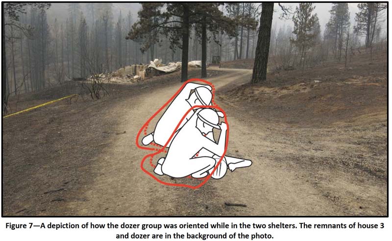
In addition to the four firefighters in Engine 642, a three-person dozer crew was entrapped when a wind shift caused the fire to spread in their direction. The extreme fire behavior that resulted, forced all fire personnel on the right flank of the fire to seek safety zones — if they could.
As the fire overtook them, the dozer crew initially parked the dozer near a garage and took refuge between the structure and the tractor. When one of them exited the dozer, he left his shelter, thinking he would not need it. Intense heat drove the three of them inside the garage. After the building began burning, they went outside and huddled under two fire shelters on a dirt road.
Below is an excerpt from the preliminary report, from the section about the engine crew’s accident:
…The right side “point of contact” saw Engine 642 driving up to him, so he whistled and swung his hand over his head, indicating they needed to turn around and get out. The “point of contact” yelled, “RTO! [Reverse tool order!],” meaning that all crews needed to follow their escape route back down the road to the safety zone. Engine 642 turned around in the road and was the first engine to head toward the escape route. One of the other 3 engines turned around at the “Y,” and another engine drove up to house 4 to turn around. The fourth engine remained at house 3.
As Engine 642 drove down toward the safety zone, the road was completely obscured by smoke. The engine jolted and dropped down as if a tire had popped. They kept driving downhill, but they had zero visibility, and the engine went off the road. The engine came to a stop, and the surviving firefighter [Mr. Lyon] got out and was immediately engulfed in flames. He went through the flames and made his way to the road…
The document released on November 18 is called an “Interagency Learning Review Status Report”, one of many stages of the Learning Review process that was adopted by the USFS in 2013. It only includes facts, some of them, that have been developed so far in the investigation. It contains no conclusions or recommendations, and does not place blame. It does, however, present some very general “questions to initiate dialogue” related to protecting structures, the use of Type 3 Incident Commanders on a developing fire, communications (as usual in EVERY report), and the use of fire weather forecasts. The narrative in the report is “abridged”, with the full narrative expected to be part of the final report. Eventually a Safety Action Plan with recommendations will released and made available to the public, according to the preliminary report.
Three landowners are suing the Washington state Department of Natural Resources, accusing the agency of negligence in not initially putting out the Golden Hike Fire that later merged with three others to become the Carlton Complex. The fire developed into the largest in the recorded history of the state, burning 256,108 acres and approximately 300 homes in July, 2014 in and around the towns of Pateros and Malott.
The suit contends that the DNR did not respond promptly to the fire, “abandoned fire lines early in the evening [on the first day] and did not return until morning”, and prevented local volunteers and residents from fighting the fire.
The three landowners are David Schulz, a former Okanogan County commissioner and 45-year firefighting veteran, his wife Deannis Schulz, and John Clees, a rancher. They are asking for damages to be determined at the trial, attorney’s fees, punitive damages, and treble damages under RCW 64.12.030.
Their attorney, Alex Thomason, represents more than other 200 clients who also lost their homes and property. If this suit is successful it could open the door to hundreds of millions of dollars in damages.
A similar case came after the 1985 Barker Mountain Fire that burned 25,000 acres in northeast Washington, including 5,000 acres of private land. The plaintiffs whose property was damaged argued that the DNR was negligent in fighting the fire since they withdrew the firefighters at the end of the first day to get rest and then reassigned them to one of many others that were burning at the same time. The case made it to the state Supreme Court where the judges upheld the decision that the state was indeed negligent, confirming the $2.6 million award to the plaintiffs. The dissenting opinion contended that the 30 mph wind that developed on the second day which caused the fire to again become active and spread far beyond control was an “act of God” and the DNR was not negligent.
Yarnell residents burned out of their homes in 2013 have no right to sue Arizona for their losses, lawyers for the state are arguing.
In filings with the state Court of Appeals, Assistant Attorney General Brock Heathcotte acknowledged the state did attempt to fight the blaze that destroyed more than 120 homes and resulted in the deaths of 19 firefighters. But he said that was only done to protect the state’s own land, “not to provide fire-suppression services to the private-property owners to protect their property.”
“The Yarnell Hill Fire was a natural consequence of natural conditions,” he wrote. “It was naturally ignited (by a lightning strike) on wildland, was fueled by natural vegetation, and spread in response to hot, dry, and windy conditions.”
And what all that means, Heathcotte argued, is there is no right to sue the state even though the fire on state land spread to private property and was not contained there.
The filings come in response to a bid by homeowners to have their day in court. Attorney Craig Knapp, representing the plaintiffs, contends the state is liable because it undertook the chore of defending the community but was negligent in that performance…
Teen who started wildfire to meet with homeowners affected
The Corvallis teen who admitted to starting the Chip Ross Park Fire in September 2014 is set to meet face-to-face with the homeowners and tenants affected by the fire.
Salem-based Neighbor to Neighbor Inc., a mediation company, has been contracted by the Benton County Juvenile Court to facilitate the process between Dawson DeWolfe and the victims of the September 2014 brush fire that destroyed 86 acres south of Chip Ross Park.
In January, Dawson DeWolfe, 16, admitted to misdemeanor charges of reckless burning, reckless endangerment and second-degree criminal mischief in a disposition — the juvenile equivalent of sentencing — in front of Benton County Judge Matthew Donohue. As part of the disposition, DeWolfe was required to attend restitution mediation.
Charlie Ikard, Neighbor to Neighbor executive director, said the mediation process could take several months. Neighbor to Neighbor representatives recently sent out letters to homeowners and tenants who experienced financial loss and direct damage to their properties as a result of the fire. Pre-mediation interviews with the homeowners are scheduled between Nov. 16 and Dec. 4…
Volunteers build sheds for wildfire victims
Building a storage shed for a fire victim in Okanogan County, Washington. Screen shot from KXLY.
Some residents whose homes burned in the Tunk Block Fire in Washington are receiving recovery assistance from volunteers. A group from Veteran Community Response, working through Foursquare Church, so far have constructed eight storage sheds for fire victims that they can use while rebuilding their homes.
No, this is not a movie. It happened for real on the Kettle Complex of fires in Washington August 27, 2015.
Below is the Rapid Lesson Sharing report from the Wildland Fire Lessons Learned Center. It is told from the perspective of the Helicopter Manager.
‘****
Operations had us go up and do some recon. One of the fires in the Complex was picking up and had spotted. We were going to check that out.
About five minutes after taking off, I look down and there’s a snake looking up at me. He’s by my right foot pedal, crawling out just inches from my foot. Right before the flight, I’d been talking to a local landowner about rattlesnakes—so that’s my first thought.
I pull my foot back from the snake and it crawls into the helicopter’s clear “chin bubble”. It looked to be about 12-18 inches long with diamonds on its back—like a rattlesnake. But I couldn’t see its tail.
I say to the pilot: “I don’t want to freak you out.”
Pilot: “What?”
“I got a snake by my feet.”
Pilot: “What?!!”
“Yeah, it’s for real.”
Can’t Do Mission Due to Snake in Helicopter
Searching for the snake.
I radio Operations and Helibase to inform that I can’t do the mission due to a snake in my helicopter.
As we return to Helibase, there is a suggestion. Apparently, the fuel truck driver likes snakes, so maybe he could get it out and we could take off.
I decide, no. Let’s not try to do that with rotors running.
So we land and shut down. The snake now slides into a hole in the cowling under my seat. While we are looking for it, he pokes his head out a few times—and retreats back inside the cowling.
Not a Rattlesnake
One of the guys gets a look at the snake’s face. He says it’s not a rattlesnake. He says it could be a bull snake; they also have diamonds on their backs. We’re informed that most of the rattlesnakes in this area are timber rattlers. So we figure this one is probably a bull snake.
Can’t Find Snake—Decide to Put Helicopter Back in Service
We pull the helicopter apart trying to find the darned snake—but we never do locate it. We make the decision to put the aircraft back in service—even though the snake could be anywhere.
So, how did the snake get into the helicopter? We think it either crawled up the long line into the belly, or was hiding in someone’s line gear or in the bucket bag when we loaded it. (A SAFECOM was filed on this incident, #15-073).
Eight Days Later, Snake Crawls Out Again
Eight days later, while the relief pilot is in flight, the snake crawls out again.
The pilot lands and the fuel truck driver grabs it. It is confirmed to be a bull snake. It is released unharmed.
****
Submitted by: Brad Mayhew, Damen Therkildsen, and Patrick Romportl with support from the Pacific Northwest Wildfire Coordinating Group.