“This is not an emergency for us. This is what we do”.
(Deputy Incident Commander Rob Allen during a Wednesday morning briefing to firefighters, emphasizing that they should not feel pressure to take unnecessary chances performing what is to them routine work for which they have spent years accumulating skills and experience.)
The above quote can be heard in the brief video below.
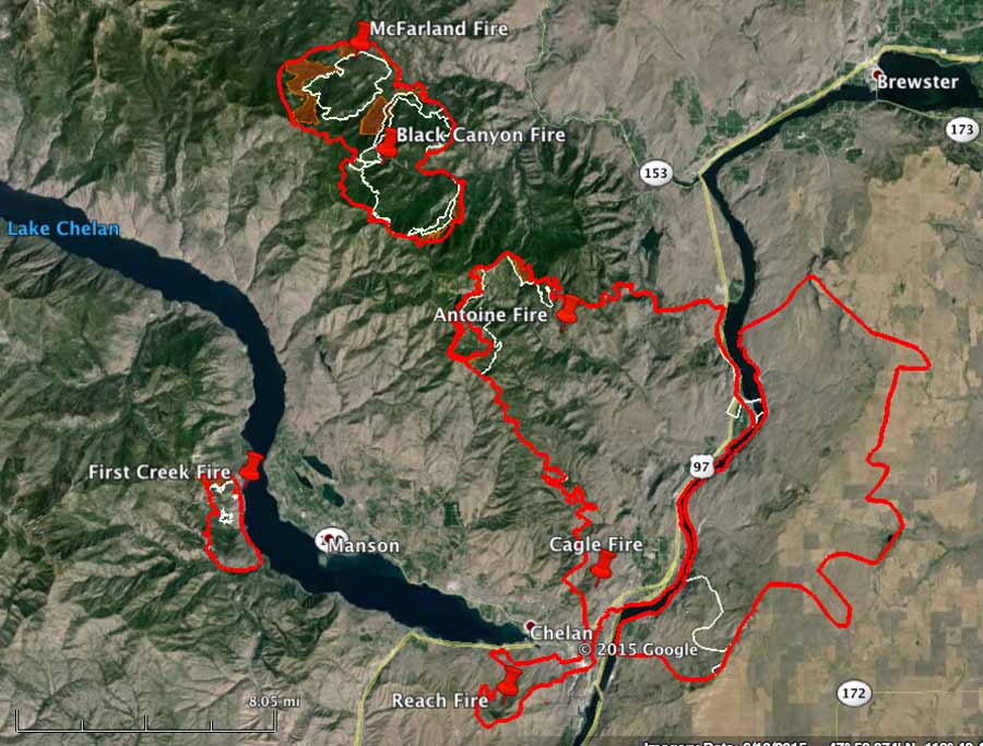
All of the fires comprising the Chelan Complex of Fires grew on Tuesday, adding about 6,000 acres to what became a total of 69,445 acres burned. The Black Canyon and McFarland Fires burned together (see map below) while expanding on almost all the length of their perimeters. The First Creek and Antoine Fires both spread on their northwest sides.
The red lines indicate the perimeters of the Chelan area fires mapped at 11 p.m. PT August 18, 2015. The white lines are from about 24 hours before. (click to enlarge)
Evacuations are still in place for approximately 2,900 residents in the greater Chelan area.
****
(UPDATED at 3:04 p.m. PT, August 18, 2015)
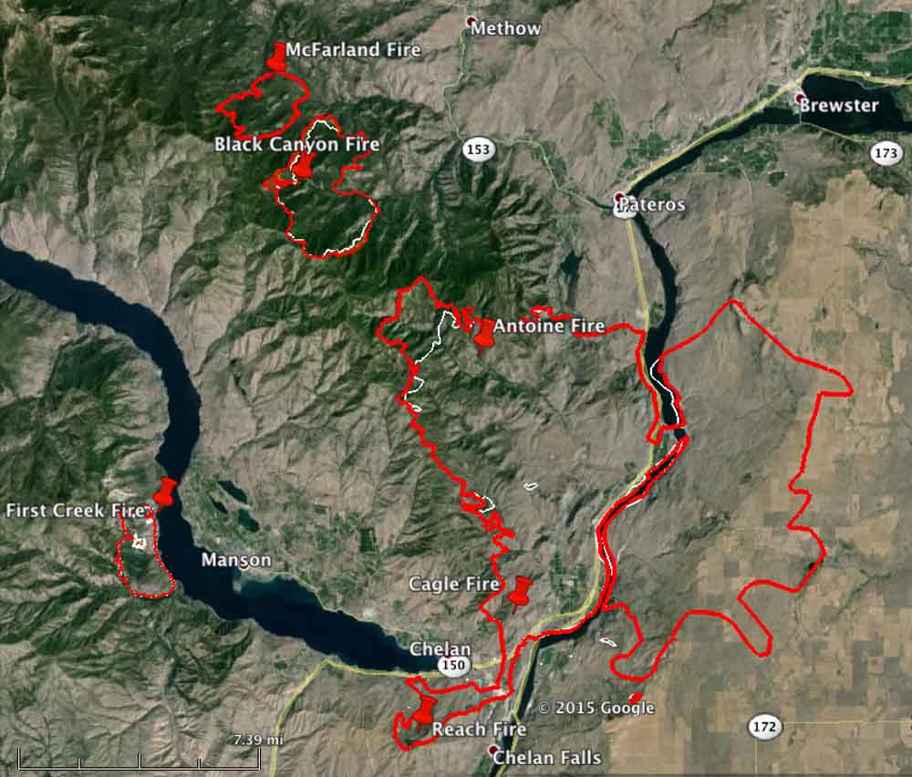
Map of Chelan area fires, 9 p.m. PT, August 17, 2015. The red line is the most current. The white line is from 1-2 days before.
Monday night the assessors office confirmed that 35 residences and 21 outbuildings have been destroyed in the fire near Chelan, Washington. The surveys are not complete and those numbers could be revised upward in the next few days.
The Sheriff’s office is increasing the patrols in evacuated areas, hoping to stop the looting has been reported in the temporarily vacant homes.
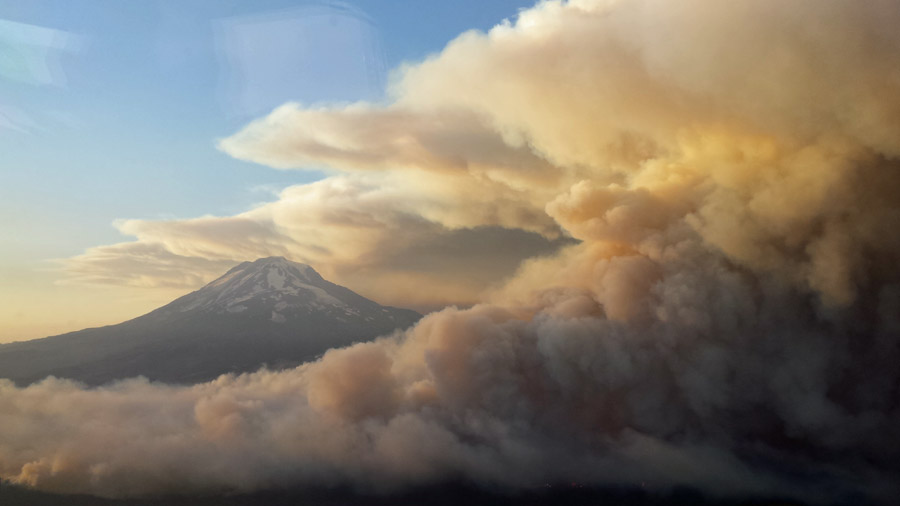
The Cougar Creek Fire burns near Mt. Adams in Washington, August 12, 2015. Photo by Jerry Messinger.
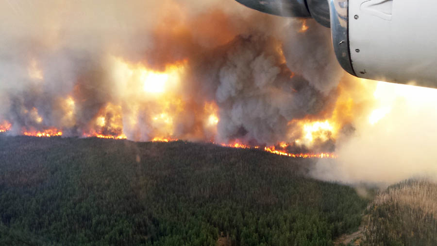
Jerry Messinger sent us these photos of the Cougar Creek Fire six miles northwest of Glenwood, Washington. The fire has burned 9,400 acres and is being managed by Washington Interagency Incident Management Team #5 (WIIMT5), Incident Commander Dave Leitch.
The Cougar Creek Fire in Washington, August 12, 2015. Photo by Jerry Messinger. He said this was taken in the morning, and the fire activity increased in the afternoon.
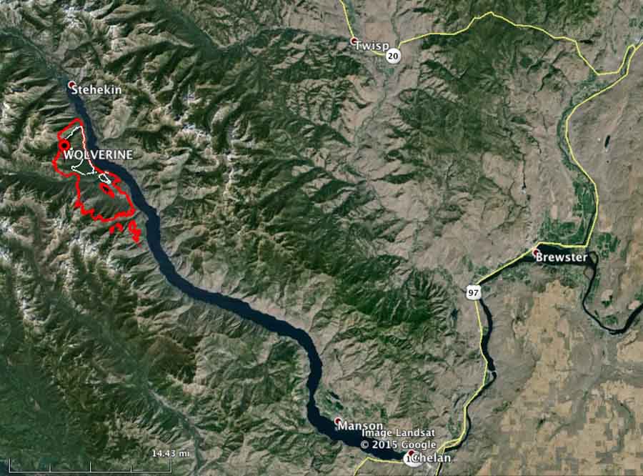
Smoke from the Wolverine Fire in north-central Washington travels into Idaho and northern Montana Sunday afternoon. (click to enlarge)
Smoke from the Wolverine Fire in north-central Washington is creating some concern in northern Montana. Some residents smelling the smoke that is blowing into Idaho and Montana are assuming the fire is nearby, but it is actually 300 to 600 miles away, depending on where you are in Montana. Some people in the state are searching for phrases on the internet such as “current Montana wildfire”.
At this time, there are no large, active fires in Montana, except for the Reynolds Fire in Glacier National Park which occasionally sends up a burst of smoke when a patch of vegetation burns out. Some residents in the state could be smelling that as well, since it was putting up some smoke on Sunday and merging with the Wolverine Fire smoke.
Below are two smoke maps. The first documents the distribution of wildfire smoke as of 4 p.m. MT, August 2. The next is a forecast for smoke at 8 p.m. MT, August 2.
Map of wildfire smoke at 4 p.m. MT, August 2, 2015. Smoke forecast for 8 p.m. MT, August 8, 2015.
To see the most current smoke reports on Wildfire Today, visit the articles tagged “smoke” at https://wildfiretoday.com/tag/smoke/
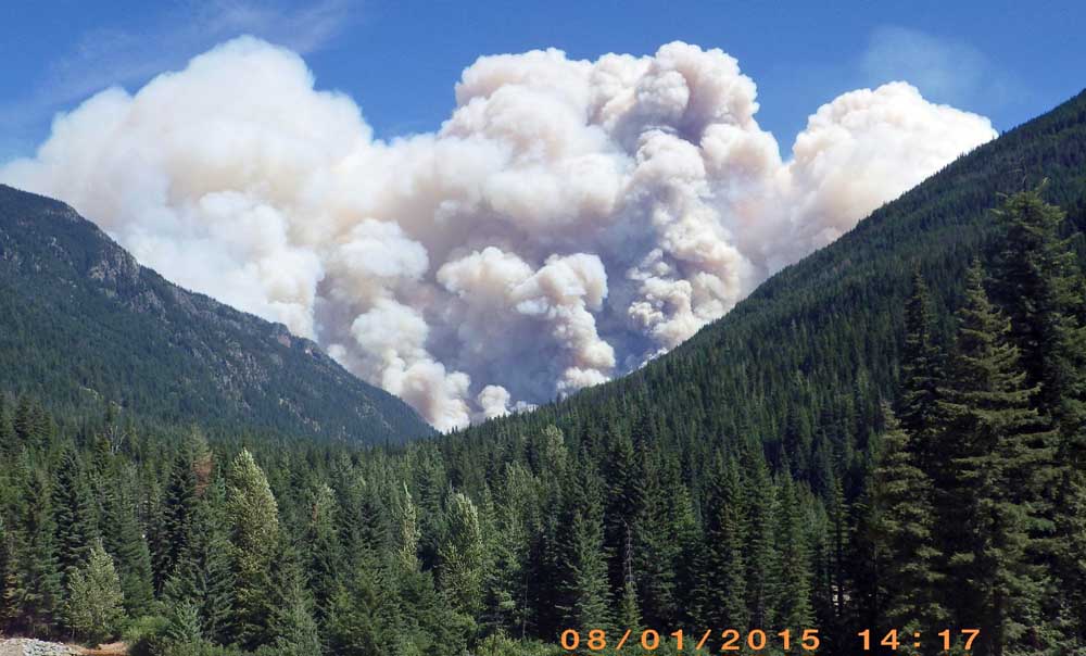
Wolverine Fire Aug 1, 2015. Photo by Mario Isaias-Vera.
Since we last reported on the Wolverine Fire on Lake Chelan in northern Washington August 3 it has grown by about 2,000 acres to 26,614, according to data from a 12:09 a.m. mapping flight on Thursday.
Map of Wolverine Fire (in red) at 12:09 a.m. August 6, 2015. The yellow line was the perimeter on August 3.
Scroll down to see other maps.
****
(UPDATED at 2:20 p.m. PT, August 3, 2015)
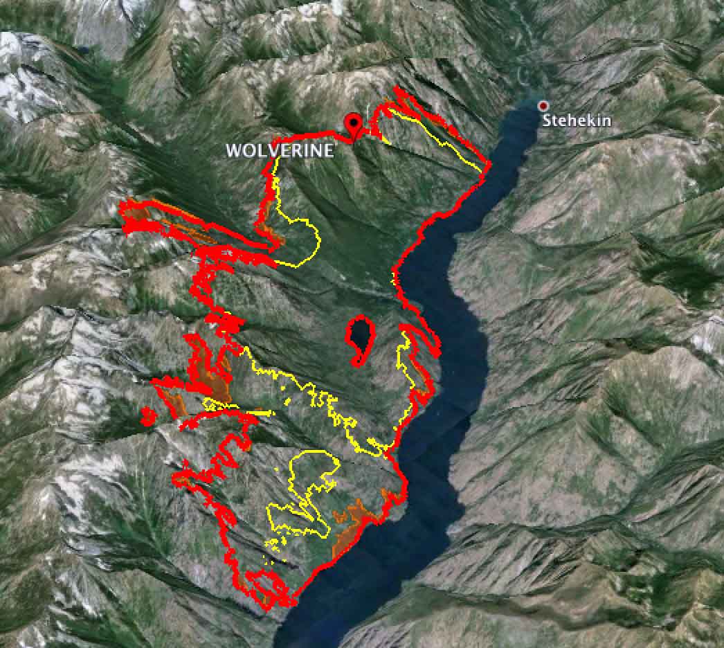
3-D map showing the perimeter (in red) of the Wolverine Fire, looking northwest at 3 a.m. PT, August 3, 2015. The yellow line was the perimeter the previous day. The lake is Chelan.
The Wolverine Fire in north-central Washington grew by more than 8,000 acres on Sunday and has now burned about 24,500 acres. Most of the fire’s spread was on the south and west sides. It progressed a mile and a half up the Railroad Creek drainage on the west side and about three miles on the southwest side in the Clone Creek and Tumble Creek drainages. The fire perimeters are on the map above. Scroll down to see other maps of the fire.
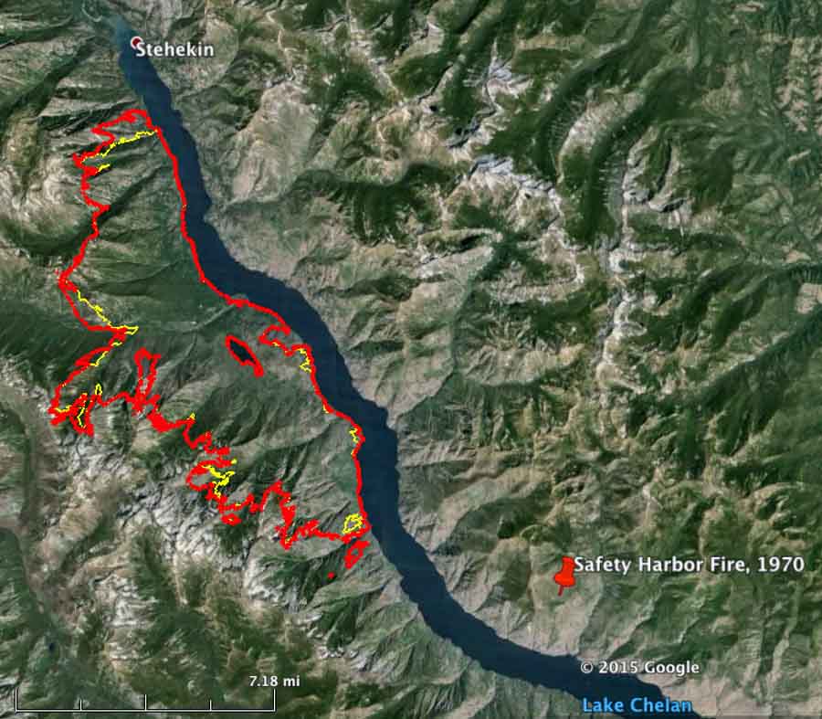
Some of the peaks where the fire is burning now reach over a mile above Lake Chelan, the east boundary of the fire. Hopefully the firefighters will not be ferried by boat up the lake to the fire and have to hike to the ridge tops, like we did on the El Cariso Hotshots on the Safety Harbor Fire in that area in 1970. Going down, weeks later, we got a ride in a helicopter. I would have preferred it to be reversed. Fly up, walk down.
****
(Originally published at 3:29 p.m. PT, August 2, 2015)
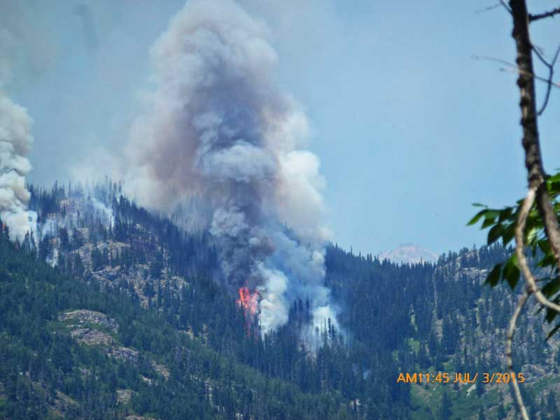
Fire activity on the Wolverine Fire, July 3, 2014. InciWeb photo.
The Wolverine Fire near the north end of Lake Chelan in north-central Washington slowly grew since it started on June 29 to 3,714 acres on July 31. That changed the next day when it more than quadrupled to 15,760 acres. (See the maps below.) After burning for more than a month, suddenly Level 3 evacuations were ordered for Holden Village and Holden Mine Remediation, which meant there was no time to grab anything — leave immediately. The evacuation was accomplished through a combined effort of Holden Village, Rio Tinto, Lake Chelan Boat Company, Chelan County Sheriff’s Office, and the US Forest Service. The incident management team provided more information:
Holden Village is not threatened but a Level 3 evacuation was necessary as Lucerne Landing was in danger which is the evacuation route for the Village.
A Level 3 evacuation has also been ordered for Lucerne, Riddle and Lightning Creek.
Sunday morning a Type 2 incident management team assumed command of the Wolverine Fire. They will be relieved Tuesday by a Type 1 team.
The Wolverine Fire has spread throughout the Burn Creek, South Lake Creek, and Forks Creek drainages and is well established in the Emerald Park Creek drainage.
It is on the 45-mile-long Lake Chelan, 23 air miles southwest of Twisp and 30 miles northwest of the city of Chelan.
Click on the maps below to see larger versions.
Map of the Wolverine Fire. The red line was the perimeter at 8 p.m. PT August 1, 2015. The white line is from 24 hours before.
The Fire Effects crew from North Cascades National Park is seen in this time-lapse video filmed over a two-hour period placing fire monitoring plots just outside fire perimeter of the Paradise Fire in Olympic National Park.
The fire that started May 15 in the Olympic peninsula rain forest has burned 1,781 acres.
I wonder to what degree the intensive human activity in the plot while establishing it affects the results.
As mountain pine beetles and other insects chew their way through Western forests, forest fires might not seem far behind. Lands covered by dead trees appear ready to burst into flame.
However, an analysis of wildfire extent in Oregon and Washington over the past 30 years shows very little difference in the likelihood of fires in forests with and without insect damage. Indeed, other factors – drought, storms, and fuel accumulation from years of fire suppression – may be more important than insects in determining if fire is more or less likely from year to year.
Scientists reached this conclusion by mapping the locations of insect outbreaks and wildfires throughout Oregon and Washington beginning in 1970. Researchers discovered that the chances of fire in forests with extensive swaths of dead timber are neither higher nor lower than in forests without damage from mountain pine beetles.
The same comparison done on forests damaged by another insect – western spruce budworm – yields a different result. The chances of wildfire actually appear to be slightly lower where the budworm has defoliated and killed trees in the past. While the mechanics of such an association are unconfirmed, it’s possible that budworm outbreaks could reduce the risk of wildfire by consuming needles in the forest canopy.
“Our analysis suggests that wildfire likelihood does not increase following most insect outbreaks,” said Garrett Meigs, lead author of a paper published this week in the open-access journal Ecosphere. Meigs is a former Ph.D. student in the Oregon State University College of Forestry and now a post-doctoral researcher at the University of Vermont.
Across more than 49 million forested acres in both states, insects and fires typically affect less than 2 percent of the land in a given year. More forestland is usually disturbed by insects than by fire.
“Most forests have plenty of fuel already,” Meigs said. “Green trees burn, not always as readily as dead ones, but they burn. The effects of insects are trumped by other factors such as drought, wind and fire management.” For example, the 2002 Biscuit Fire, the region’s largest at nearly 500,000 acres, occurred in an area with little tree damage from insects.
“Even if mountain pine beetle outbreaks do alter fuels in a way that increases flammability, the windows of opportunity are too small – and fire is too rare – for those effects to manifest at landscape and regional scales.”
“In the case of the budworm, our findings suggest that there may be a natural thinning effect of insect-caused defoliation and mortality, and it is possible that insects are doing some ‘fuel reduction’ work that managers may not need to replicate,” said Meigs. That possibility needs more research, he added.
These results are consistent with other studies that have investigated the likelihood of fire across the West. For example, a 2015 study published in the Proceedings of the National Academy of Sciences by University of Colorado scientists found that despite extensive outbreaks of mountain pine beetles in the Rockies and the Cascades, fires in recent years were no more likely to occur in beetle-killed forests than in forests not affected by the insects.
Public perception may reflect our experience with starting campfires, said John Bailey, Oregon State professor of forestry and co-author of the Ecosphere paper.
“We choose dead and dry wood for kindling, not green branches,” Bailey pointed out. “A dead branch with lots of red needles is ideal. At the scale of a forest, however, the burning process is different. Wildland fire during severe weather conditions burns less discriminately across mountainsides.”
For managers of forestlands, these results suggest that emphasis needs to be put on fuel reduction, forests near communities and on preserving ecosystem services such as biodiversity and water quality. “Forests will continue to burn whether or not there was prior insect activity,” Meigs and his co-authors write, “and known drivers like fuel accumulation and vegetation stress likely will play a more important role in a warmer, potentially drier future.”
In addition to Bailey, Meigs’ co-authors included John L. Campbell, Harold S. J. Zald, David C. Shaw and Robert E. Kennedy, all of Oregon State. Funding support was provided by the NASA Earth and Space Science Fellowship Program and the USDA Forest Service.
A helicopter working on the Blue Creek Fire 10 miles east of Walla Walla, Washington, had a mechanical failure while in flight Monday evening, according to the Union-Bulletin which quoted Heather Lee of Walla Walla County Emergency Management. The pilot autorotated the helicopter and walked away from the incident. He refused to be transported to an hospital, Ms. Lee said.
Autorotation can be used when there is a loss of engine power in a helicopter. It is a state of flight where the main rotor system turns by the action of air moving UP through the rotor, rather than engine power driving the rotor, forcing air down. With the right pedal and the collective property configured, the main rotor will continue to rotate and the rate of descent and direction of flight can be controlled. When nearing the ground the pilot will flare the aircraft producing, hopefully, a fairly soft landing, that may include sliding on the skids for a bit.
Congratulations to the pilot for successfully executing the maneuver.
Today much of the eastern part of Washington is again under a Red Flag Warning until 8 p.m. for westerly winds of 15 to 25 mph and a relative humidity of 10 to 20 percent.
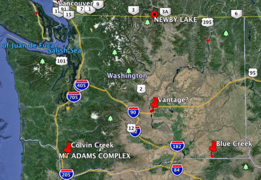
I-90 Fire between Vantage and George
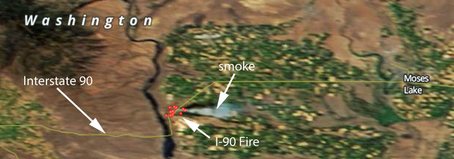
Satellite image showing the location of the I-90 Fire July 20, 2015 (click to enlarge)
We have seen this referred to as the “I-90 Fire” today. It has burned about 900 acres and has a state Type 3 incident management team assigned. Interstate 90 has been subject to intermittent closures and at 7 a.m. on Tuesday was closed.
Blue Creek Fire
UPDATE at 5:34 p.m. PT, July 21, 2015:
The Blue Creek Fire has grown to 4,000 acres, the Union-Bulletin reports, and has destroyed one residence on Klicker Mountain Road and seven outbuildings near the intersection of Klicker Mountain Road and Blue Creek Road. More areas are threatened including the Bluewood Ski area and the Mill Creek Watershed.
The Union-Bulletin has a gallery of excellent photos of the fire.
****
A helicopter working on the Blue Creek Fire 10 miles east of Walla Walla, Washington, had a mechanical failure while in flight Monday evening, according to the Union-Bulletin which quoted Heather Lee of Walla Walla County Emergency Management. The pilot autorotated the helicopter and walked away from the incident. He refused to be transported to an hospital, Ms. Lee said. Fire Aviation has more information about the helicopter incident.
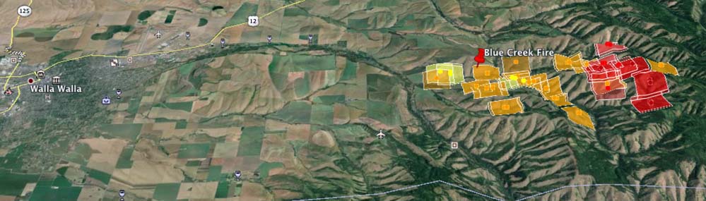
The red, yellow, and brown squares represent the location of heat detected on the Blue Creek Fire by a satellite at 12:45 p.m. July 21, 2015. The map is looking north, and Walla Walla can be seen on the left side. (click to enlarge)
The fire has grown to 2,500 acres due to extreme fire behavior and long-range spotting. Very little information is being provided by the Washington DNR, but they reported that 32 engines and 3 helicopters are assigned, and eight structures have burned . Evacuations and road closures are in effect.
Colvin Creek Fire, now part of the PC Complex of five fires
A Type 2 incident management team (Leitch/Holloway) is assigned to this complex which has burned 100 acres. Very little information is being provided about this complex of fires.
****
(Originally published at 4:43 p.m. PT, July 20, 2015)
Three new fires have erupted in Washington recently. Much of the state is under a Red Flag Warning on Monday.
Fire between Vantage and George
On Sunday a fire between Vantage and George required the closure of Interstate 90. Later in the day it reopened, but on Monday the fire awakened, or it may be a new ignition in the same area — reports are unclear at this point. But the Interstate is again closed between mileposts 138 and 149 and approximately 50 structures are being evacuated.
KOHO radio reports it has burned 700 to 800 acres.
The Blue Creek fire is causing evacuations along Blue Creek Road 10 miles east of Walla Walla. Monday afternoon the Blue Mountain Interagency Dispatch Agency Center said it had burned at least one structure and about 350 acres of vegetation. Several air tankers were working the fire Monday afternoon.
Monday morning the reported size of the Colvin Creek Fire was 70 acres, and a Type 2 Incident Management Team, WA Team 5 (Leitch/Holloway), was responding. The fire is 11 miles southeast of Kalama.
This video illustrates how the Paradise Fire is spreading through the rain forest in Olympic National Park in Washington. The fire easily climbs up the lichen and moss on a tree then drops burning embers to the ground or onto an adjacent tree branch where it can continue to spread.
The fire started May 5 and has burned 1,520 acres. It is being managed by a team from the National Incident Management Organization (NIMO).
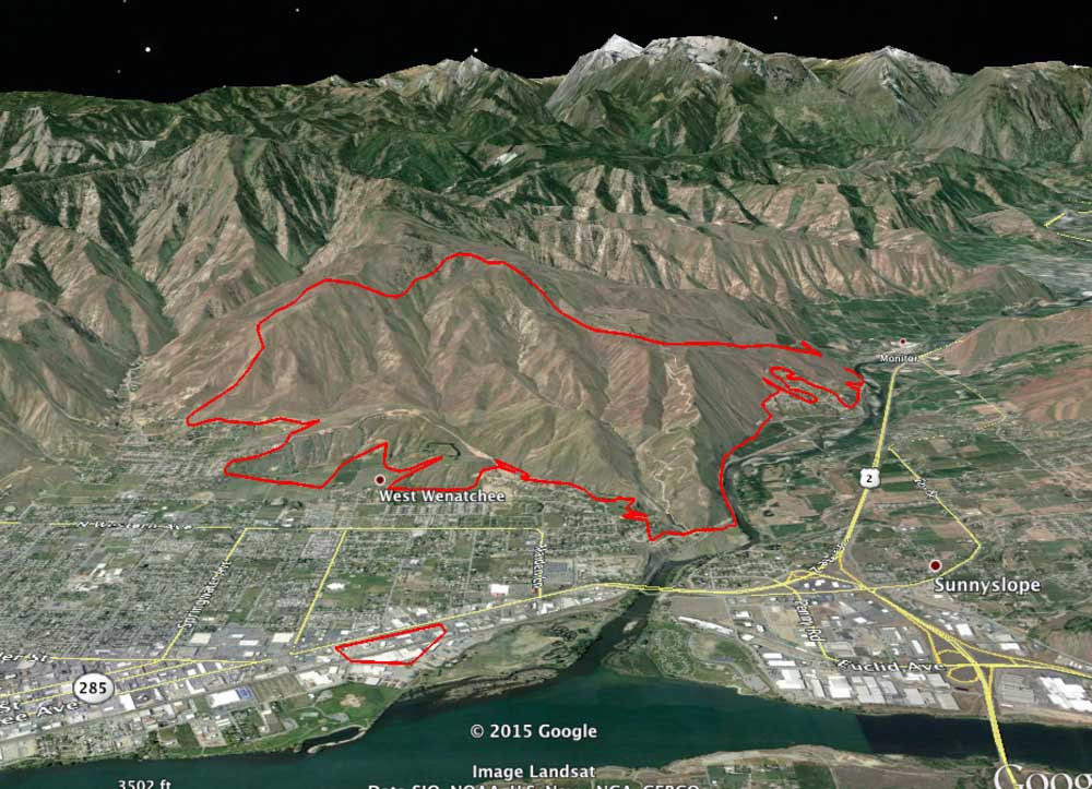
3-D map of the Sleepy Hollow Fire in Wenatchee, Washington, looking west, 1 a.m. PT, June 30, 2015. Note the spot fire near the river that is 1.2 miles east of the main fire. (click to enlarge)
The Sleepy Hollow Fire that swept into Wenatchee, Washington destroying 29 homes announced the early beginning of the wildfire season in the state. A spot fire 1.2 miles in front of the main fire that for a while was not noticed while structures were burning on the other side of town, spread into four industrial buildings.
The Los Angeles Times has an interesting article about the fire and the current situation in Washington that has led to concern about how the state will deal with the conditions this summer, and beyond. Below are excerpts from the article:
…”This is a stress test for 2070,” said Cliff Mass, a professor of atmospheric sciences at the University of Washington. “We’re being tested now with the warmth and lack of snowpack that will be typical at the end of the century. How do we get through it?”
Climate experts say the current conditions in the Pacific Northwest are part of a short-term climate phenomenon, but they warn that temperatures are rising everywhere. In Seattle, for example, that means warmer, wetter winters and warmer, drier summers.
[…]
Two months ago, Democratic Gov. Jay Inslee declared a statewide drought emergency, a snowpack drought rather than a precipitation drought. At the time, state officials warned that the 2015 fire season could be earlier and fiercer than Washington has ever seen.
Now that it has begun in earnest, “it’s worse than I feared,” Goldmark said.
[…]
Sitting on the tailgate of a pickup truck in front of what had been her home of 18 years, Sharon Cooper marveled Wednesday that all of the precautions she and her husband, Nick, had taken through the years did no good against the Sleepy Hollow fire.
Not the concrete shingles. Not the backyard fire hose with high-pressure water. Not the regular efforts to whack away the brush.
“This is August kind of stuff,” Cooper said, mourning the community’s loss, wondering whether she and Nick would rebuild. “Even sometimes the Fourth of July is rainy and yucky here…. Everything’s changing.”
…As of Monday, according to the CBC, Saskatchewan had 112 active fires across the province, bringing the year-to-date total to 569. That’s nearly three times the tally for 2014, and the acreage in flames is 10 times a normal year’s.
The newest fires near La Ronge, toward the northern fringe of settlement in the province, prompted evacuation of 8,000 more people, bringing to 13,000 the number waiting out the battles in emergency shelters — the largest evacuation in provincial history. More than half of them had to be lodged in neighboring Alberta…