Wildfire news, April 9, 2013

200 fires near Mayo, Ireland

Firefighters have responded to approximately 200 wildfires near Mayo in Ireland in the last ten days. The worst of the gorse fires in recent days have been at Shanwar, Foxford; Killawalla, Westport; and Treanagleragh, Kiltimagh.

Distress flare causes wildfire

Some rocket scientists boaters in Virginia have been charged with misdemeanors after they started a wildfire by discharging a flare distress signal from a boat on Smith Mountain Lake. The fire burned about a quarter-acre and one round hay bale. There was no emergency that precipitated the discharge of the flare.  Someone witnessed the incident and called 9-1-1. The Smith Mountain Lake Marine Volunteer Fire & Rescue responded and quickly extinguished the fire.

Wildfire across from Indiana Fire Department

Two rocket scientists males, in an effort to burn the insulation off (probably stolen) copper wire across from the Porter Fire Department in Indiana at 2 a.m. Friday morning, accidentally allowed the fire to escape, igniting nearby vegetation. The Fire Department responded and put out the fire. One of the males escaped, while the other was transported to the Porter County Jail.

A wildfire followed by winter storm in Colorado

Yesterday Wildfire Today told you about the Red Flag Warning and Winter Storm Warning for Colorado, both happening on the same day. One of the areas not covered by the Red Flag Warning, Sterling County in the northeast corner of the state, had a 2,600-acre wildfire yesterday. Firefighters were no doubt thankful for the snow storm that followed a few hours later. Here is the forecast for Sterling today:

Snow with widespread blowing snow. High near 20. Wind chill values as low as -10. Windy, with a north wind 26 to 28 mph, with gusts as high as 43 mph. Chance of precipitation is 90%. Total daytime snow accumulation of 2 to 4 inches possible.

Wildfire leaders in the Black Hills discuss the coming fire season

KEVN TV in Rapid City interviewed two wildfire honchos in the Black Hills of South Dakota, asking them about the outlook for this fire season. KEVN’s video and article are HERE, but below are some excerpts:

Jay Esperance, Director of South Dakota Division of Wildland Fire:

It’s looking like it will be at least an above average fire season. The southern Black Hills I’m really worried about.

Todd Pechota, Fire Management Officer for the Black Hills National Forest:

From all indications that we are hearing from fire weather forecasters, we’re preparing as if we are going to have another very active fire season in 2013.

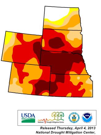
If the current drought continues and if the weather this summer is hot and dry, it could be a busy fire season in portions of the Great Plains and Rocky Mountains. Below is the Drought Monitor for ND, SD, NE, KS, WY, and CO.

Drought Monitor, April 4, 2012

Red Flag Warning and Winter Storm Warning the same day for Colorado

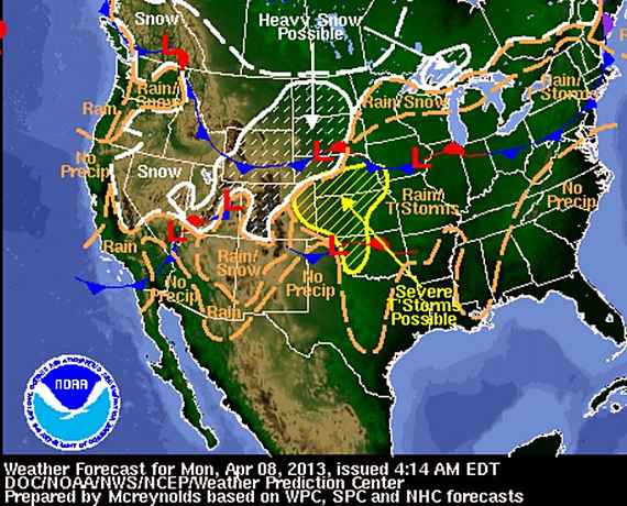
Weather forecast map 4-8-2013

The weather forecast for the western United States is complicated today. Portions of western Colorado are under both Red Flag Warnings AND Winter Storm Warnings. The southwest and west central part of the state should experience strong southwest winds this afternoon with gusts of 30 to 40 mph with low humidities and isolated thunderstorms. Then after 6 p.m. all that changes, with some areas expecting to receive 10 to 20 inches of snow accompanied by 20 to 30 mph winds with gusts close to 50 mph.

Spring season prescribed fires in the Black Hills of South Dakota are on hold since a Winter Storm Warning is in effect through Wednesday morning. The forecast calls for snow accumulations of 9 to 16 inches with a 100 percent probability of precipitation through Tuesday night. The last time I remember it being 100 percent was a couple of months ago when we got zero precipitation in the southern Black Hills.

The National Weather Service prediction for Tuesday is for up to half an inch to one inch of precipitation in some areas of Colorado, Wyoming, Nebraska, Kansas, South Dakota, and Texas, while other Red Flag Warnings are in effect for portions of California, Arizona, New Mexico, and Texas.

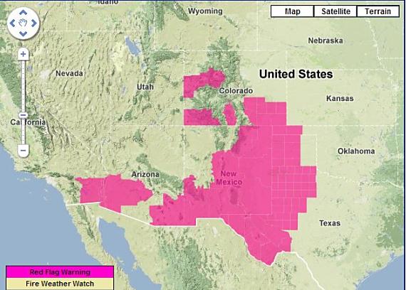
Red Flag Warnings, April 8, 2013

wildfire Red Flag Warnings, 4-8-2013

Red Flag Warnings for enhanced wildfire danger have been issued by the National Weather Service for areas in Oklahoma, Texas, Colorado, New Mexico, Arizona, and California.

***

The Red Flag Warning map above was current as of 9:40 a.m. MT on Monday. Red Flag Warnings can change throughout the day as the National Weather Service offices around the country update and revise their forecasts. For the most current data, visit this NWS site.

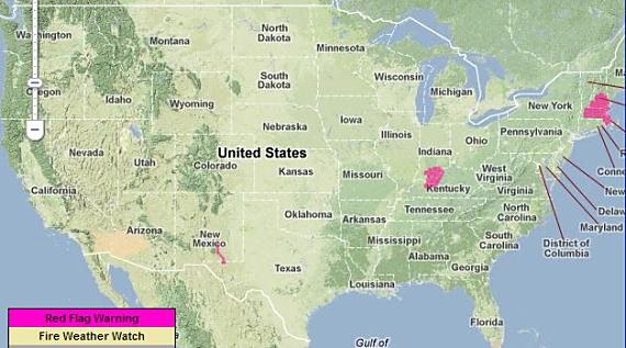
Red Flag Warnings, April 6, 2013

wildfire Red Flag Warnings, 4-6-2013

Red Flag Warnings for enhanced wildfire danger have been issued by the National Weather Service for areas in New Mexico, Kentucky, Indiana, Massachusetts, and New Hampshire.

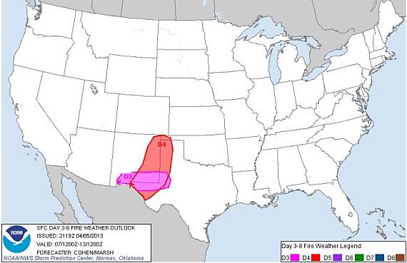
The NWS predicts there will be a Critical Risk for wildfire danger in New Mexico and western Texas for the next few days.

Critical fire weather
Critical fire weather April 7-13, 2013

***

The Red Flag Warning map above was current as of 9 a.m. MT on Saturday. Red Flag Warnings can change throughout the day as the National Weather Service offices around the country update and revise their forecasts. For the most current data, visit this NWS site.

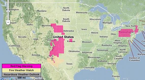
Red Flag Warnings, April 5, 2013

Red Flag Warnings, 4-5-2013

Red Flag Warnings and Fire Weather Watches for enhanced wildfire danger have been issued by the National Weather Service for areas in New Mexico, Texas, Colorado, Nebraska, Kansas, Pennsylvania, New York, and Wyoming.

***

The map above was current as of 11:20 a.m. MT on Friday. Red Flag Warnings can change throughout the day as the National Weather Service offices around the country update and revise their forecasts. For the most current data, visit this NWS site.

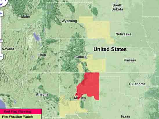
Red Flag Warnings, April 4, 2013

Red Flag Warnings

Red Flag Warnings and Fire Weather Watches for enhanced wildfire danger have been issued by the National Weather Service for areas in New Mexico, Colorado, Nebraska, and Wyoming.

***

The map above was current as of 9 a.m. MT on Thursday. Red Flag Warnings can change throughout the day as the National Weather Service offices around the country update and revise their forecasts. For the most current data, visit this NWS site.