Wildfire news, November 5, 2012

More than 100,000 lightning strikes in South Australia

Thunderstorms over the last couple of days have blasted South Australia with more than 100,000 lightning strikes. One report says 173,000 strikes left 80,000 residents without electrical power. Firefighters are working on over a dozen fires on the Eyre Peninsula, Kangaroo Island and Fleurieu Peninsula.

Fire jumps Interstate 15 in Cajon Pass

A fire that started near Interstate 15 in Cajon Pass in southern California jumped the interstate and burned 350 acres at the last report. The Devore Fire began at 10:55 a.m. and was 5 percent contained by late afternoon, with full containment expected by 6 p.m. Tuesday. The fire is being fought by 450 personnel and required the evacuation in the Matthew’s Ranch area. More information is available at InciWeb.

Fuel filter being recalled after starting fires

A fuel filter used on diesel engines is being recalled after failures of the unit caused two fires. The California Air Resources Board announced that that the LongMile diesel particulate filter made by Cleaire Advanced Emission Controls is being voluntarily recalled after a second fire attributed to the device. The most recent fire burned three acres on August 4, but in September of 2011 another fire blackened 3,600 acres in Washington and cost $5.2 million to suppress. The initial attack on that fire was made by a group of nuns using buckets of water.

Wildfire potential, November through February

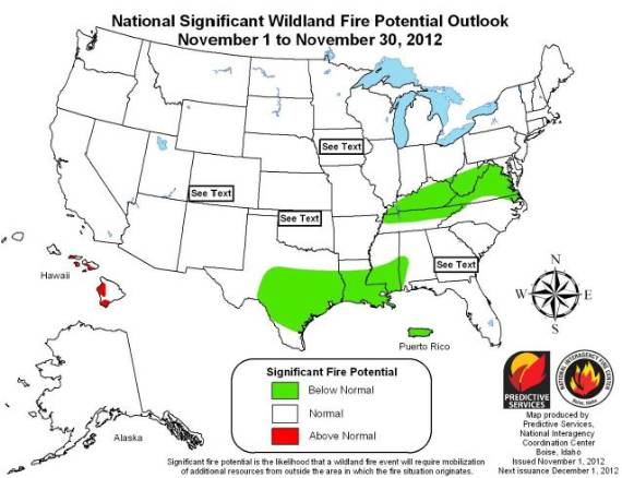
The Predictive Services section at the National Interagency Fire Center has issued their National Wildland Fire Potential Outlook for November, 2012 through February, 2013. As we get closer to winter, there are no areas identified as having above normal wildfire potential for that period.

Wildfire potential, November, 2012

Wildfire potential, December, 2012 - February, 2012

Here is an excerpt from the report:

Significant Fire Potential

  • For November above normal significant fire potential only remains across small portions of the Hawaiian Islands. By the December through February timeframe no above normal significant fire potential is expected in the U.S.
  • Below normal significant fire potential is expected across much of the southeastern U.S. for the entire forecast period
  • Elsewhere expect near normal significant fire potential to exist. In many areas of the western U.S. this indicates fall and winter conditions that are generally considered out of fire season.

Firefighters prepositioned in southern California for Santa Ana winds

WindFirefighting resources have been prepositioned in southern California for the last two days in order to be ready for any wildfires that break out during the predicted strong Santa Ana winds. There has been “light initial attack” fire activity over the last couple of days, according to the Southern California Geographic Area Coordination Center, but no large fires so far. Maybe this can be credited not only to the not-quite-as-strong-as-expected winds, but to aggressive initial attack by the fire agencies. One fire near Fontana burned a few hundred acres before firefighters put it out. Photos of that fire by tjvphoto can be found HERE.

The Red Flag Warning is still in effect through Saturday evening. While the winds have been fairly strong, the predicted northeast winds of 20 to 30 mph gusting at 50 to 60 mph have not quite materialized in most areas. The effect of the Santa Ana condition has been quite variable in southern California, but the Chilao weather station on the Angeles National Forest has been recording some of the highest wind speeds. Since 12:53 a.m. on Saturday it has seen sustained winds in the 30s with gusts above 40 mph; the strongest gust was 49 mph.

Red Flag Warnings, 8:26 a.m. PT, October 27, 2012
Red Flag Warnings, 8:26 a.m. PT, October 27, 2012. These warning areas can change throughout the day as various NWS offices update their forecasts.

The forecast is for northeast winds of 25 to 30 mph gusting up to 30 on Saturday, but the relative humidities will be very low, in some areas going down to 5 percent during the afternoon. The winds will decrease in the late afternoon when the pressure gradient relaxes as the surface high over the Great Basin shifts.

Red Flag Warning for southern California

Red Flag Warnings
Red Flag Warnings, 9:25 a.m. MT, October 25, 2012

Red Flag Warnings for extreme fire weather are in effect for most of the forested and brush-covered lands in southern California. The pattern along the Colorado River is interesting, and indicates that the weather forecasters put some thought into this, rather than simply using state boundaries as has been done in some cases previously.

The weather forecasts vary from one location to another in southern California, but they generally call for strong northeast winds of 20 to 30 mph gusting at 50 to 60 mph, along with very low humidities. The Red Flag Warnings mostly begin late on Thursday and continue into Saturday.

The map was current as of 9:25 a.m. MT. Red Flag Warnings can change throughout the day as the dozens of National Weather Service offices around the country update and revise their forecasts. For the most current data, visit this NWS site.

Thanks go out to Ken

Red Flag Warnings, October 17, 2012

Red Flag Warnings, 949 am MT, October 17, 2012
Red Flag Warnings, current as of 9:49 a.m. MT, October 17, 2012 (Click to enlarge)

Red Flag Warnings for extreme fire weather are in effect for much of the central United States, plus portions of northern California.

The map was current as of 9:49 a.m. MT. Red Flag Warnings can change throughout the day as the dozens of National Weather Service offices around the country update and revise their forecasts. For the most current data, visit this NWS site.

Strong winds in South Dakota through Thursday

Weather forecast, Wind Cave NP October 16-18, 2012

The weather forecast above is from the National Weather Service and is for Wind Cave National Park in southwest South Dakota. (Click on the image to see a larger version.)

Very strong winds and enhanced fire danger will prevail over South Dakota through Thursday. Thanks to a cold front moving through the area, sustained wind speeds in some area should be in the 20s, 30s, or 40s with gusts in some areas at 40 to 60 mph.

Below is an excerpt from a message distributed today by Darren R. Clabo, South Dakota State Fire Meteorologist.

=============================================================

A strong upper level trough will force a potent cold front to push across the state this evening. A few showers are possible along this frontal boundary and some of the weather models are even showing a wetting rain over western SD and the Black Hills.

Some lightning may accompany these showers so we’ll have to watch for any new ignitions.

Temperatures will quickly drop with this front but the real change will be seen in the winds: southwest winds will switch to the northwest and dramatically increase in speed. Gusts to 40 mph are possible overnight behind the front as it crosses the state.

Post-frontal conditions can then be expected tomorrow. Highs will only reach the mid to upper 50s across the prairies with mid 40s expected over the Black Hills. A very strong pressure gradient will persist throughout the day. This will allow the northwest winds to reach sustained speeds 35-45 mph with gusts exceeding 60 mph. A High Wind Watch is in place for this event. In addition, the post-frontal airmass will be quite dry and minimum RHs will range from 15% over southwestern SD to 25% over northeastern SD.

Critical fire conditions will ensue. Expect Extreme Fire Danger over all of the SD plains with Red Flag Warnings likely over East River. Explosive fire growth is possible any in the state tomorrow with the wind and exceptionally dry fuels. The strong northwest winds will continue throughout Wednesday night.

Thursday will not bring much relief as the northwest winds will like again be in the 30-40 mph range with gusts exceeding 50 mph. There may be some precipitation across northeast SD but the rest of the state will see dry conditions with enhanced fire danger once again. Highs will be in the 50s.