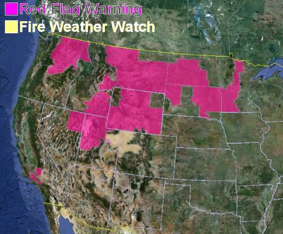
Quite a bit of the country is under a red flag warning today, including portions of California, Washington, Oregon, Idaho, Nevada, Utah, Montana, Wyoming, North Dakota, South Dakota, and Minnesota. Other than California, this may be one of the last red flag warnings for these states, as precipitation and cooler weather will be moving into some of these areas.
Tag: weather
Wildfire potential and fire behavior advisories
Fuels and fire behavior advisories
Five geographic areas have released updated fuels and fire behavior advisories: Northwest, Northern Rockies, Rocky Mountain, Western Great Basin, and northern California.
Wildfire potential
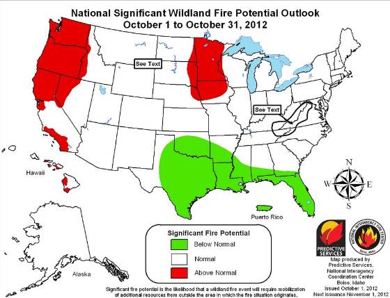
The Predictive Services section at the National Interagency Fire Center has issued their National Wildland Fire Potential Outlook for October, 2012 through January, 2013. If it is correct, Minnesota, the northwest, and portions of California and Iowa will be active in October. After that, it’s southern California.
Here is an excerpt from the NIFC report:
==============================================================
Significant Fire Potential
- For October above normal significant fire potential is predicted across the northwestern quarter of the U.S. including portions of Washington, Oregon, Idaho and California. Above normal significant fire potential also exists across portions of the upper Midwest. The mountains and foothills of central and Southern California will also experience above normal significant fire potential. Portions of the Hawaiian Islands continue to see elevated significant fire potential as well.
- The southeastern U.S. will continue to see periodic precipitation events and reduced significant fire potential.
- The rest of the country will have normal significant fire potential.
- As the fall leaf drop season develops the potential exists for a return to above normal significant fire potential across portions of the Appalachian Mountains.
- Also during mid-October through early November Southern California will likely experience periodic off shore flow events leading to elevated significant fire potential.
Red flag warnings and record-breaking heat expected in California
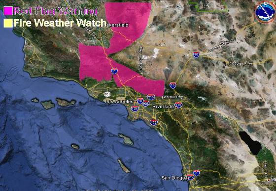
A weather forecast for record-breaking triple-digit heat and single digit humidities has brought out a red flag warning for some areas in southern California for Monday and Tuesday. The temperatures are expected to be about 20 degrees hotter than normal, between 95 and 105 at the lower elevations in the mountains of Los Angeles and Ventura Counties on Monday, then a few degrees cooler on Tuesday. Downtown Los Angeles is expected to hit 100 degrees on Monday, with it reaching 105 degrees in Burbank and Pasadena.
Northeast winds at 10 to 20 mph with 30 mph gusts are expected on Monday, with Tuesday afternoon bringing 25 mph onshore winds.
The map below shows the area in southern California covered by the red flag warning, which is in effect from 6 a.m. Monday until 6 p.m. PDT Tuesday.
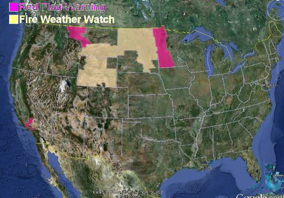
There is also a red flag warning for some areas in northwest Montana for gusty winds and low humidities from 11 a.m. through midnight MDT on Monday. The winds are expected to be southwest at 15 to 25 mph with gusts up to 50, with the humidities as low as 16 percent.
The passage of a cold front has resulted in a red flag warning for western Minnesota from 2 p.m. until 7 p.m. CDT on Monday. Winds should be northwest at 20 with gusts up to 30 mph along with humidities as low as 20 percent.
A fire weather watch is in effect for areas in Wyoming, Montana, North Dakota, and South Dakota.
Updated drought map
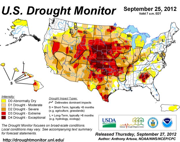 An updated drought monitor map was released today, current as of September 25, 2012. It is similar to the map we posted on September 8, but has a few areas moving into the next higher level of dryness. As before, most of the United States is in some form of drought.
Dry lightning could bring more fires to the Northwest
Originally published September 22, 2012, 8:47 a.m. PT
The dry lightning that is in the forecast for portions of Washington and Oregon could bring more fires to an area that already has its hands full dealing with dozens of blazes. On Friday the National Weather Service issued a Red Flag Warning for the lightning, but now the timing of the event has changed. That forecast predicted it would begin Friday night, but a revision now says isolated to scattered lightning will start Saturday night and continue through Sunday night.
The areas affected include the Cascade Mountains in central and north Oregon, the southern Washington Cascades, and the Columbia basin in Washington. If any rain occurs, it will be light and amounting to less than 1/10 inch. The thunderstorms will be high-based and could produce outflow winds of up to 45 mph.
We are not aware of a large amount of lightning that has occurred in this area yet this weekend, however as of 8:45 a.m. PT, there have been a couple of positive strikes detected very recently in north-central Oregon, which seems to be ahead of the NWS’s revised schedule.
We will update this article later on Saturday if we hear of any significant dry lightning occurring. I hope our loyal readers in Washington and Oregon will post comments about their observations as well.
The map below shows the Red Flag Warnings for Washington and Oregon and a Fire Weather Watch for western Utah.
The smoke map indicates that wildfire smoke created in Washington and Idaho is migrating across the southern tier of states.

Wildfire briefing, September 21, 2012
Idaho fires burn through uranium mine areas
As if firefighters and local residents didn’t have enough to worry about in Idaho, now we are hearing about wildfires that have burned through, or may burn through, areas with uranium mines. At least one of the mines is in the footprint of the Mustang Complex Fire. In case you have not received your copy of Uranium Market News, here is an excerpt from that publication:
Friday September 21, 2012, 1:55pm PDT
Reuters reported an Idaho wildfire has burned through three former mining sites with traces of radioactive uranium and thorium and is currently burning through a fourth site.
As quoted in the market news:
As a precaution, state environmental authorities planned to take air samples in North Fork, a small community in the fire zone north of Salmon, to assess any radioactive hazards posed by fire damage to the sites.
One area of concern is a defunct uranium mine and milling operation 5 miles west of North Fork, where the U.S. Environmental Protection Agency conducted a cleanup several years ago of polluted soil, hazardous wastes and piles of raw uranium and thorium ore.
The Missoulian has more information about the radioactive uranium and thorium issue.
The northwest to receive more dry lightning Friday night and Saturday
Dry lightning and thunderstorms with minimum rain are in the forecast for parts of Washington, Oregon, and Idaho, according to a fire weather forecast from the National Weather Service: (do you love their all-caps format as much as I do?)
HIGH PRESSURE WILL BEGIN TO WEAKEN AS A COMPACT LOW PRESSURE SYSTEM BARRELS INTO NORTHERN OREGON. ISOLATED TO SCATTERED DRY THUNDERSTORMS WILL BE POSSIBLE WITH THIS FEATURE EARLY SATURDAY MORNING THROUGH SUNDAY. GREATEST THREAT FOR SATURDAY MORNING AND SATURDAY AFTERNOON WILL BE ALONG THE CASCADE MOUNTAINS AND VALLEYS MAINLY SOUTH OF LAKE CHELAN. THE THREAT OF THUNDERSTORMS WILL SHIFT TO THE SOUTHEAST ACROSS SOUTHEAST WASHINGTON AND INTO THE CENTRAL IDAHO PANHANDLE SATURDAY NIGHT INTO SUNDAY. MOISTURE WILL BE INCREASING SATURDAY NIGHT INTO SUNDAY.
With fire approaching, ski resort activates snow making equipment
Usually snow making equipment at ski resorts gets the summer off, but at the Mission Mission Ridge Ski & Board Resort near Wenatchee, Washington they are using it to wet down the ski slopes as the Table Mountain Fire advances toward the area. More information.


