October wildfire potential to remain high in Montana, Northern California, and the Carolinas

New four-month forecast is available

3:49 p.m. MDT Oct. 5, 2021
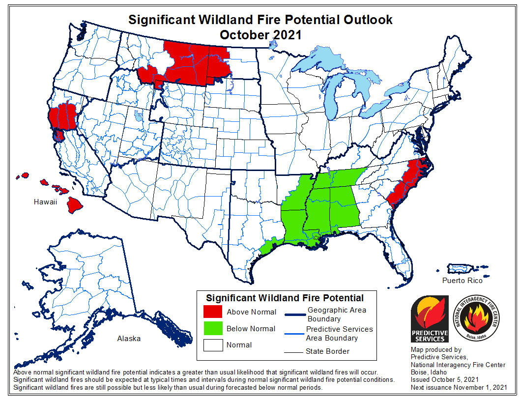
wildland fire potential October 2021An updated forecast for wildland fire potential for the next four months was issued October 5 by the National Interagency Fire Center. If their predictions are correct:

  • October: The potential in Southern California will be below average through January; Northern California and parts of Idaho and Montana will be above average in October, while the Mid-South will be below average.
  • November: Northern California will remain above average along with Central Texas, Central Oklahoma and parts of the East Coast;
  • December: Central Texas, Central Oklahoma and parts of the East Coast will be above average.
  • January: Central Texas, Central Oklahoma, most of Florida, and the southern portions of Alabama and Georgia will be above normal.

The data from NIFC shown here represents the cumulative forecasts of the ten Geographic Area Predictive Services Units and the National Predictive Services Unit.

Below:

  • An excerpt from the NIFC narrative report for the next several months;
  • Additional NIFC monthly graphical outlooks;
  • NOAA’s three-month temperature and precipitation forecasts;
  • Drought Monitor;
  • Keetch-Byram Drought Index.

“Climate outlooks indicate warmer than normal conditions are likely for much of CONUS into winter with temperatures likely closer to normal in the Pacific Northwest, Northern Rockies, and into the western Great Lakes. Above normal precipitation is likely across the Pacific Northwest into the Northern Rockies through fall with below normal precipitation likely for the southern half of the West and the southern and central Plains. The Southeast is forecast to have below normal precipitation through fall, but portions of the region could be susceptible to heavy rainfall events.

“Above normal significant fire potential is forecast to continue into October for southwest Montana and eastern Montana into western North Dakota as these areas have missed the heavier precipitation in September. Western slopes of the northern Sierra through the Sacramento Valley to the Coast Ranges from the Bay Area to Ukiah, CA are forecast to have above normal potential through November, with leeside locations in Hawaii likely to have above normal significant fire potential into November as well. Portions of Oklahoma, Texas, and the eastern Carolinas into Florida are likely to have above normal significant fire potential this fall into winter, with portions of the Mid-Atlantic forecast to have above normal potential in November and December. All other areas are likely to have near normal significant fire potential or are out of fire season through January.”


wildland fire potential November 2021

wildland fire potential December 2021

wildland fire potential January 2021

90-day outlook, temperature and precip
Continue reading “October wildfire potential to remain high in Montana, Northern California, and the Carolinas”

Frontal passage brings Red Flag Warnings and precipitation to Western states

Red Flag Warnings
Red Flag Warnings. The areas in CA, NV, ID, and CO expire Monday evening. The areas in ND, SD, WY, and most of MT expire Tuesday evening.

A frontal passage is bringing strong winds into most of the Western U.S., prompting Red Flag Warnings in seven states. The Red Flag Warnings generally expire Monday night except in North Dakota, South Dakota, Wyoming, and most of the areas in Montana, which expire Tuesday evening.

The cumulative precipitation forecast through Saturday evening shows at least a small amount of precipitation occurring in many western areas, but many locations will receive less than 0.10″.  Even some snow or rain/snow mix is in the forecast for portions of Oregon, Washington, Nevada, and Idaho.

Most of the southern two-thirds of California and Nevada are expected to remain dry through Saturday.

Forecast for cumulative precipitation
Forecast for cumulative precipitation, Monday evening through Saturday evening.

Dry lightning possible in California and northwestern states Thursday

Lightning with little or no rain could start more wildfires

forecast weather fire wildfire dry lightning Sept. 9, 2021 map
Forecast for lightning with little or no precipitation for 6 a.m. MDT Thursday until 6 a.m. MDT Friday.

Areas in 10 western states are included in forecasts for isolated or scattered thunderstorms with little or no rain Thursday afternoon and night, prompting Red Flag Warnings.

Nationally 23,467 firefighters are actively attempting to suppress 58 large fires and another 47 are being managed under a less than full suppression strategy. If this dry lightning event in drought-affected desiccated vegetation creates a new round of wildfires it would put additional stress on the wildfire suppression system that is already struggling to mobilize enough personnel and equipment for the existing 105 fires. Only one of the 16 Type 1 Incident Management Teams is available for new fires.

The National Weather Service predicts “…dry and breezy conditions conducive to fire spread across portions of the western Great Basin northeastward to the northern High Plains. Deep-layer ascent associated with the approaching upper trough will also support isolated to scattered thunderstorms across the western Great Basin and portions of the Pacific Northwest into the northern Rockies. Several fire starts will be possible where thunderstorms occur given the extremely dry fuels in place.”

Some locations from central Nevada northwestward to central Oregon and eastward to south-central Montana could receive more than half an inch of rain, but lightning could occur with no rain. Of particular concern is the area from central Oregon into far Northern California where fire managers should expect dry thunderstorms.

Red Flag Warnings forecast weather fire wildfire dry lightning Sept. 9, 2021 map
Red Flag Warnings Sept. 9, 2021.

The analysis in the tweet below raises the possibility of lightning with little or no rain in California’s South Bay, Central Coast, Santa Cruz Mountains, and the Los Padres National Forest in Monterey County. This area is under a Red Flag Watch.

Wildfire potential in September expected to remain above normal in parts of the Northwest

Predicted to be above normal in Northern California through November

Wildfire potential September

The forecast for wildland fire potential issued September 1 by the National Interagency Fire Center predicts that the potential for wildfires in Northern California will be above normal September through November. Northern Minnesota and the northwest one-quarter of the country  will also be above normal in September. Hawaii and Wyoming could be busy in September and October. The southeast Atlantic coast states may experience above normal fire activity in October and November, but December looks to be pretty average in all 50 states.

The data from NIFC shown here represents the cumulative forecasts of the ten Geographic Area Predictive Services Units and the National Predictive Services Unit.

Below:

  • An excerpt from the NIFC narrative report for the next several months;
  • Additional NIFC monthly graphical outlooks;
  • NOAA’s three-month temperature and precipitation forecasts;
  • Drought Monitor;
  • Keetch-Byram Drought Index.

“Climate outlooks indicate warmer than normal conditions are likely for much of CONUS through fall. Wetter than average conditions are likely across western Washington for the fall with below normal precipitation likely across the Southwest, Great Basin, central Rockies, and much of the Plains. The Southeast is forecast to have near normal precipitation through October but turn drier in late fall and early winter.

“Much of Southern Area and areas south of the Ohio River are likely to have below normal significant fire potential in September, but much of the southeast US and Mid-Atlantic is forecast to have above normal fire potential in October and November. Normal significant fire potential is forecast for Alaska along with most of Eastern Area through the period. The entire US is forecast to have normal fire potential in December.

“Above normal significant fire potential is forecast to continue for September across much of the Northwest and portions of the Great Basin, Northern Rockies, and Rocky Mountain Geographic Areas. Most of these areas will return to normal fire potential in October and November except for portions of Wyoming, northwest Colorado, and the Black Hills, which will remain above normal into October. Much of northern California is forecast to have above normal potential through November with leeside locations in Hawaii likely to have above normal significant fire potential into October.”


Wildfire potential October

Continue reading “Wildfire potential in September expected to remain above normal in parts of the Northwest”

Wildfire potential predicted to remain high in California, the Northwest, and Northern Rockies

In August and September, 2021

wildfire potential outlook August

The forecast for wildland fire potential issued August 1 by the National Interagency Fire Center predicts that the Northwest, Northern Rockies, and the mountainous areas of California will have above normal fire potential in August and September. Even into October much of the Northern Rockies, Northern California, and coastal mountains of Southern California will still be above normal.

The data from NIFC shown here represents the cumulative forecasts of the ten Geographic Area Predictive Services Units and the National Predictive Services Unit.

Below:

  • An excerpt from the NIFC narrative report for the next several months;
  • Additional NIFC monthly graphical outlooks;
  • NOAA’s three-month temperature and precipitation forecasts;
  • Drought Monitor;
  • Keetch-Byram Drought Index.

“Climate outlooks indicate warmer than normal conditions are likely for much of the CONUS, especially the West, into fall. The northern Intermountain West is likely to have drier than normal conditions in August, expanding to include most of the West during fall. Near normal precipitation is likely with the monsoon in August, which should continue to alleviate drought. However, drought is likely to expand and intensify across much of the West into fall.

“Much of Southern Area and areas south of the Ohio River are likely to have below normal significant fire potential through September, but much of the Southeast U.S. is forecast to have above normal fire potential in October and November. Normal significant fire potential is forecast for Alaska along with most of Eastern Area.

“Above normal significant fire potential is likely to remain in portions of northern Minnesota into August. Above normal significant fire potential is forecast to continue through September for much of the Northwest, Northern Rockies, and northern portions of the Great Basin and Rocky Mountain Geographic Areas. Most of these areas will return to normal fire potential in October and November. Most mountains and foothills in California are forecast to have above normal potential through September with areas prone to offshore winds likely to retain above normal potential into October and November in southern California. Leeside locations in Hawaii are likely to have above normal significant fire potential into October.”


wildfire potential outlook September

Continue reading “Wildfire potential predicted to remain high in California, the Northwest, and Northern Rockies”

Above normal wildfire activity predicted in the Northwest for July and August

Posted on Categories UncategorizedTags ,

wildfire potential July, 2021

As we enter what are usually two of the busiest months of the wildland fire season in the West, the forecast for wildland fire potential issued July 1 by the National Interagency Fire Center predicts that California and virtually the entire northwest one-quarter of the United States will have above normal fire potential in July and August.

The data from NIFC shown here represents the cumulative forecasts of the ten Geographic Area Predictive Services Units and the National Predictive Services Unit.

Below:

  • An excerpt from the NIFC narrative report for the next several months;
  • Additional NIFC monthly graphical outlooks;
  • NOAA’s three-month temperature and precipitation forecasts;
  • Drought Monitor;
  • Keetch-Byram Drought Index.

“Drought expanded and intensified over the West with more than 90% of the West now in drought. More than half of the West is in the highest two categories of drought. Numerous all-time record high temperatures were set in the Pacific Northwest, northern Great Basin, and Northern Rockies at the end of June as part of a historical heat wave. The first surge of monsoonal moisture arrived in the Southwest, Colorado, and southern Great Basin during the last few days of June.

“Climate outlooks indicate warmer than normal conditions are likely for much of the CONUS, especially the West, through summer. Much of the Rockies and the northern half of the West are also likely to have drier than normal conditions through September. Near normal precipitation is likely with the Southwest Monsoon in July, which should help alleviate drought conditions and significant fire activity, but drought is likely to expand and intensify across much of the West through the summer.

“Much of the Southern Area is likely to have below normal significant fire potential through the summer with mostly near normal significant fire potential in Eastern Area and Alaska into fall. Above normal significant fire potential is likely to remain in portions of northern Minnesota into August.

“Above normal significant fire potential will expand northward into the Great Basin and Rocky Mountain Geographic Areas through August with areas closer to the monsoon likely returning to near normal significant fire potential in July and August. Most of the Pacific Northwest, Northern Rockies, and northern Great Basin are expected to have above normal significant fire potential in July and August with areas beginning to return to normal significant fire potential in September and October. Most of the mountains and foothills in California are forecast to have above normal significant fire potential through September with areas prone to offshore winds retaining above normal potential through October. Leeside locations, saddles, and divides in Hawaii are likely to have above normal significant fire potential into October.”


wildfire potential August, 2021

wildfire potential September, 2021

wildfire potential October, 2021

Outlook for precipitation and temperature, July, August, and September
Outlook for precipitation and temperature July, August, and September. Made June 17, 2021. NOAA.

Drought Monitor

Keetch-Byram Drought Index