Washburn Fire grows in Yosemite National Park

It has burned into a grove of giant sequoia trees, some of which are 3,000 years old

Updated 5:08 p.m. PDT July 11, 2022

Washburn Fire, July 11, 2022
This photo of the Washburn Fire posted at about 4 p.m. PDT July 11 appears to have been taken near the South Fork of the Merced River, looking west. Compare it to the west-facing 3-D map below and you can pick out the large rock face on the north side of the ridge. The column of smoke appears to be coming from an area east or northeast of the sequoia grove, near the park boundary. Photo by Courtney Aviation.

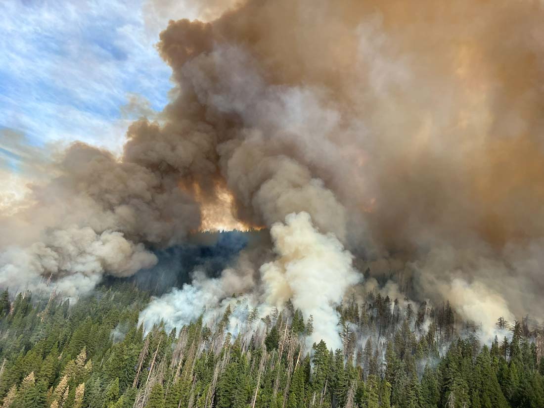
Late Monday afternoon activity on the Washburn Fire increased substantially. There have been reports of at least one spot fire on the north side of the South Fork of the Merced River. There were also reports of spot fires across highway 41 on the west or northwest side of the fire.

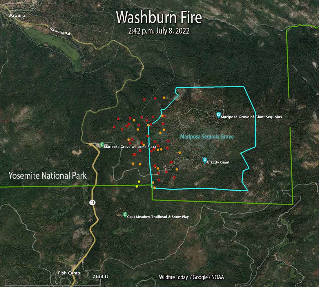
Satellite heat detections at 2:36 p.m. Monday showed numerous heat sources east of the earlier perimeter of the fire across the park boundary on the Sierra National Forest, and on the northwest side of the fire between Highway 41 and the river.

In mid-afternoon the FIRIS aircraft mapped the fire at 2,720 acres.

Washburn Fire at 3:13 p.m. July 11, 202
Washburn Fire at 3:13 p.m. July 11, 2022. AlertWildfire.

Updated 7:11 a.m. PDT July 11, 2022

Washburn Fire, 3-D map 10 p.m. July 10, 2022
Washburn Fire, 3-D, looking east at 10 p.m. July 10, 2022.

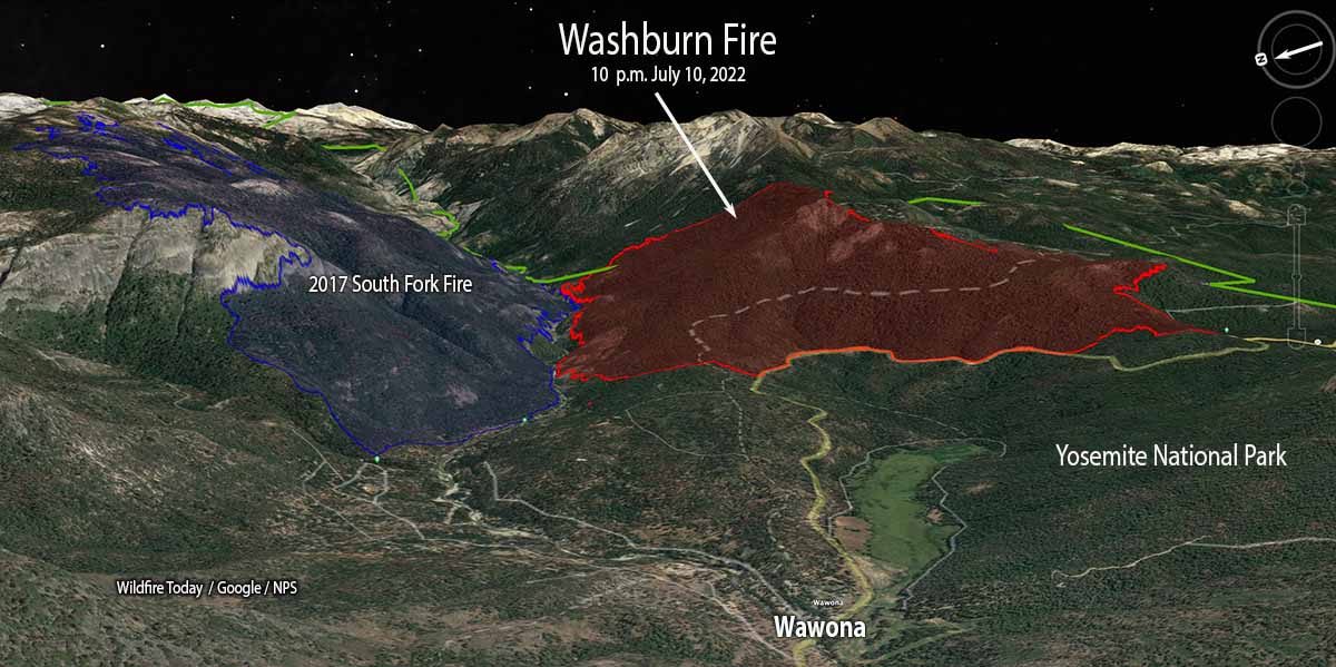
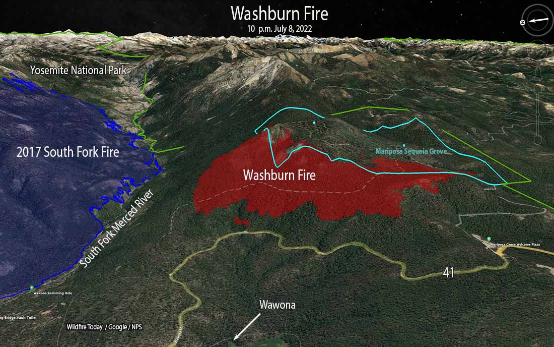
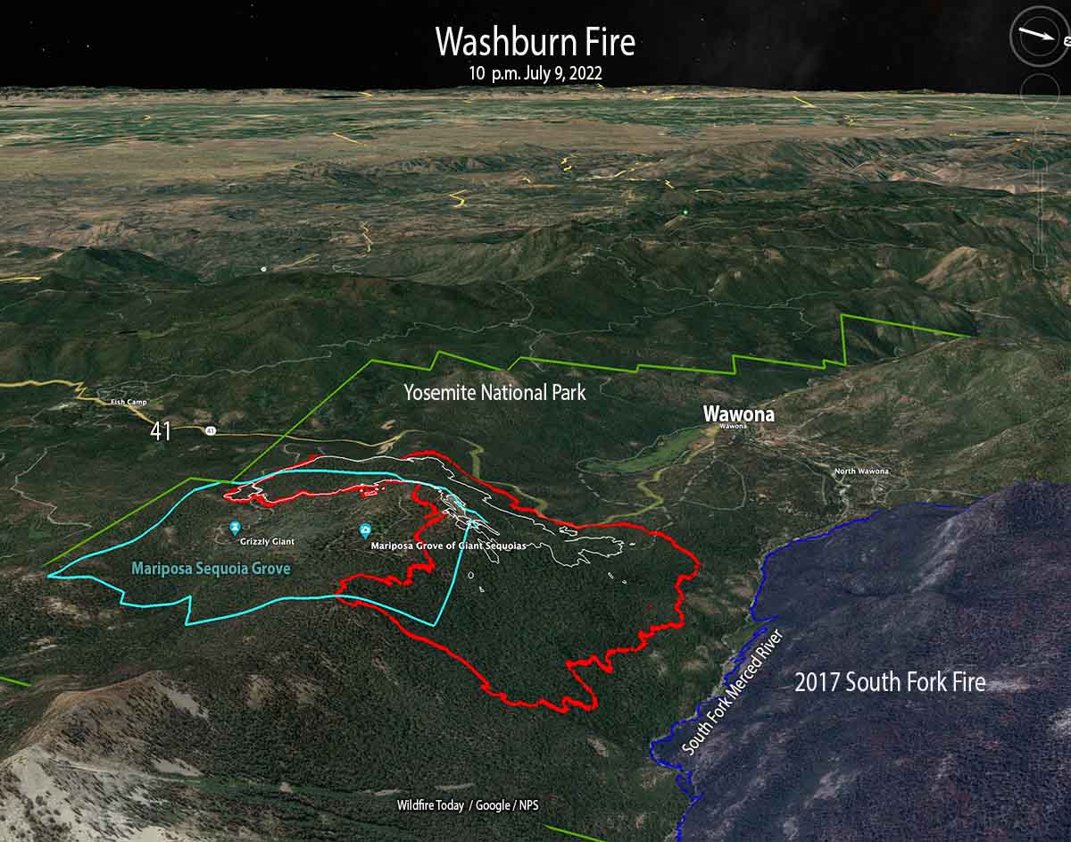
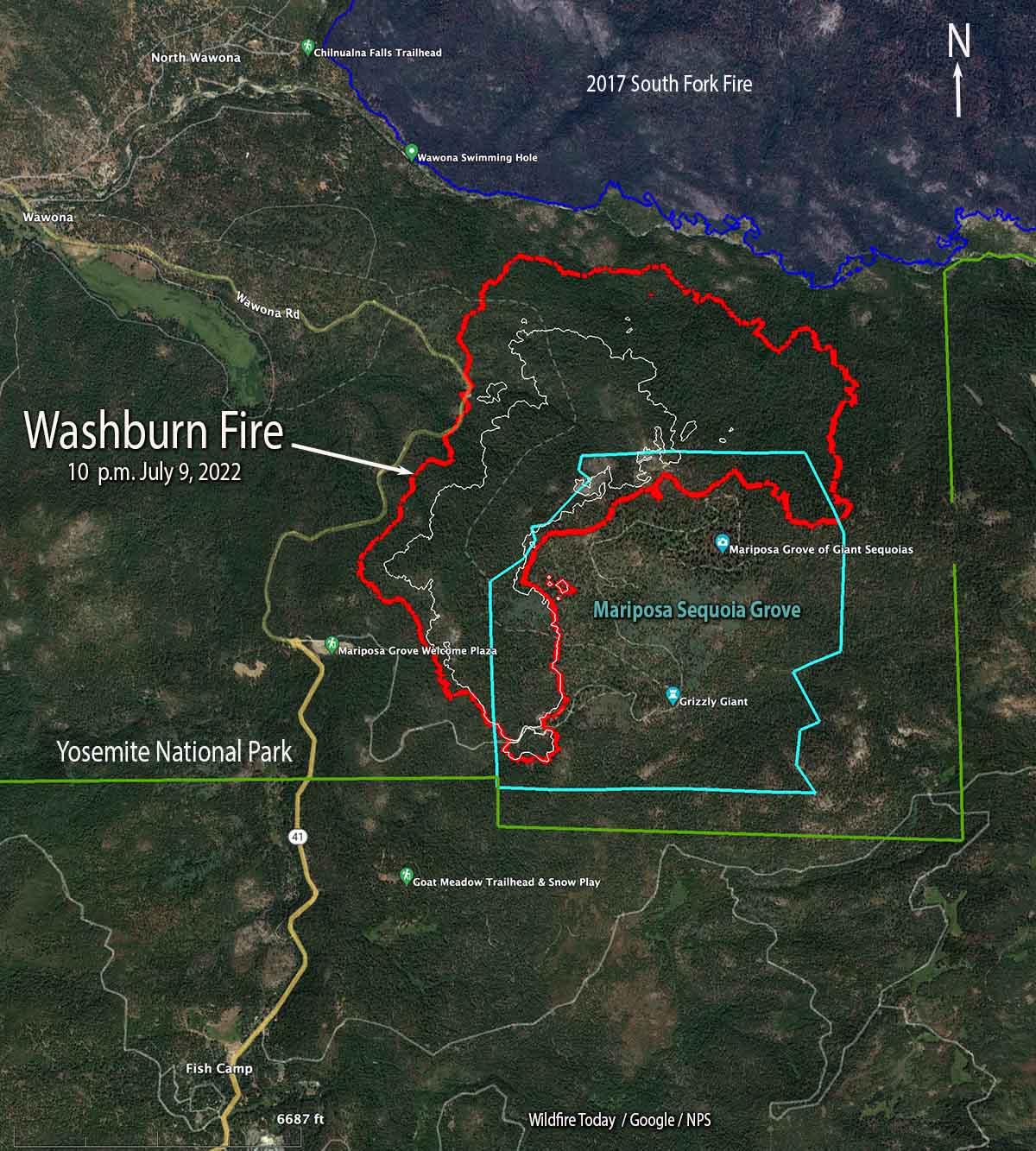
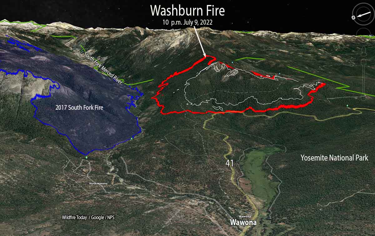
The Washburn Fire in Yosemite National Park in California continued to spread west, north, and east on Sunday. On Saturday and Sunday the size increased by 749 acres, bringing the total to 2,340 acres according to a mapping flight Sunday at 10 p.m.

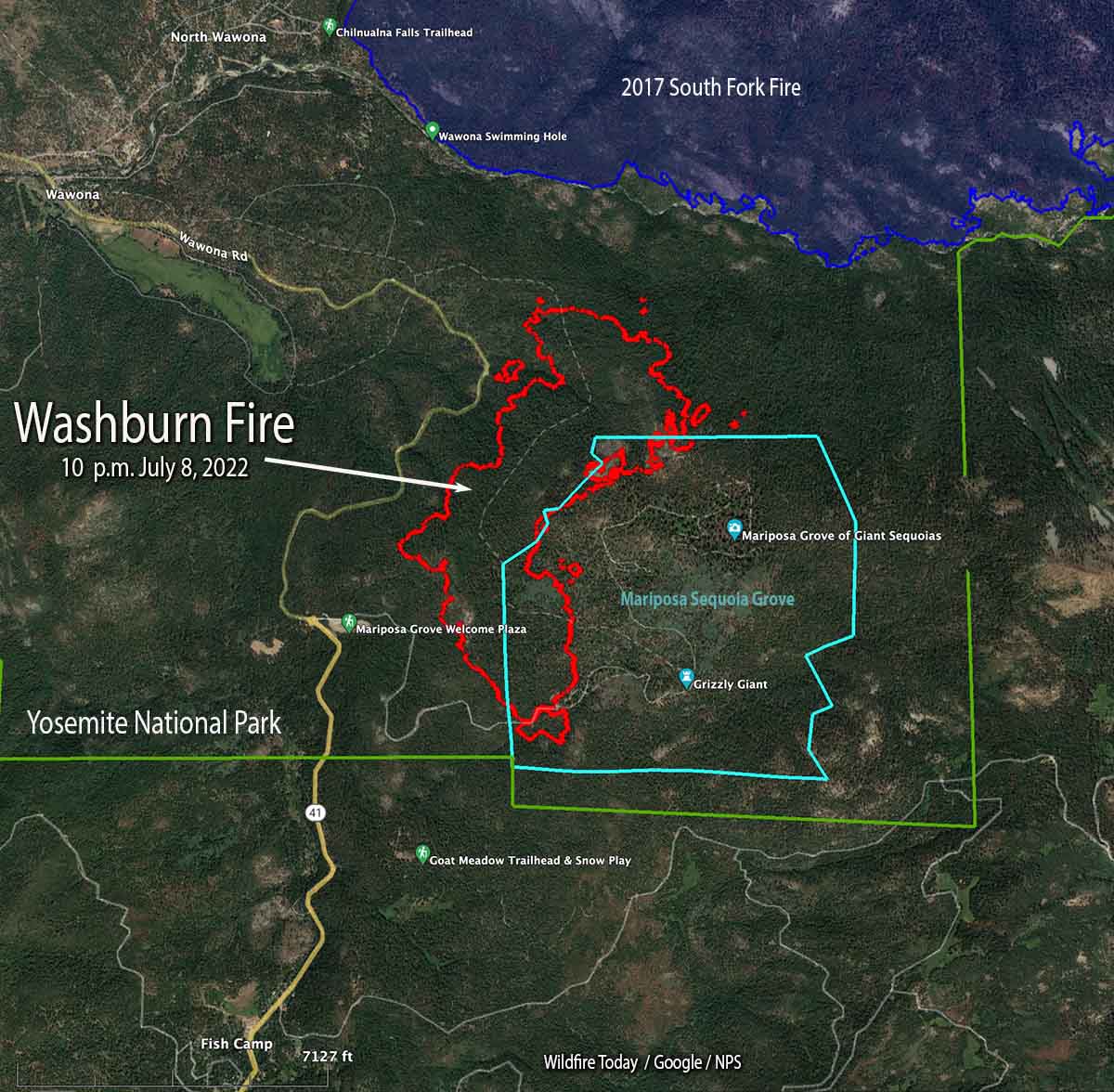
Approximately 340 acres of the fire are within the Mariposa Grove of giant sequoias. While protective foil-based structure wrap is not being used on the sequoias themselves, additional methods are being employed including the removal of fuels around the trees, and ground-based sprinkler systems to increase humidity and fuel moisture near the sequoias. The Mariposa Grove has a long history of prescribed burning and studies have shown that these efforts reduce the impacts of high-severity fire.

Washburn Fire map 10 p.m. July 10, 2022
Washburn Fire map. The red line was the perimeter at 10 p.m. July 10, 2022. The white line was the perimeter 24 hours before.

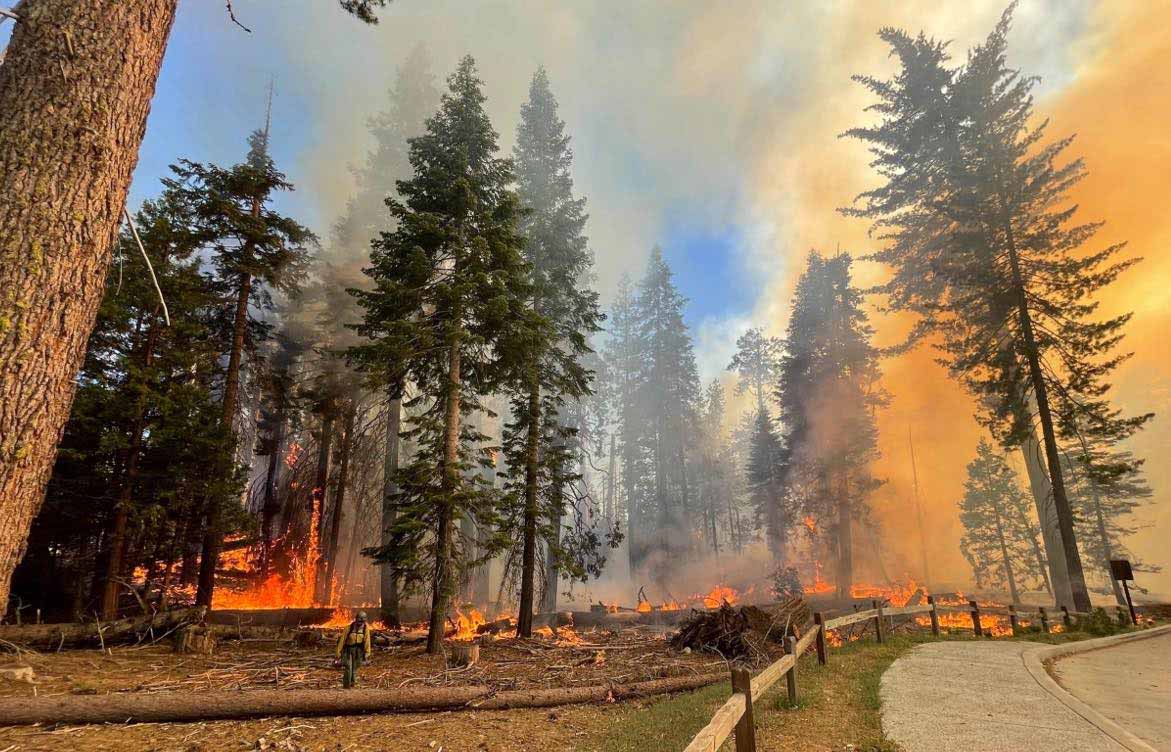
Firefighters are constructing direct fireline on the fire edge where possible, but are also using tactical firing to tie it in with barriers, such as Highway 41 on the west side.

Evacuations are in effect in the Wawona area. A map is available showing the locations. The Wawona Road (Highway 41) is closed from the South Entrance to Henness Ridge Road.  Yosemite West remains accessible from the northern side of the Wawona road.

Washburn Fire, 3-D map 10 p.m. July 10, 2022
Washburn Fire, 3-D map, looking west at 10 p.m. July 10, 2022.

The weather forecast for the fire area (6,400 feet above sea level) predicts for Monday and Tuesday 81 degrees, 3 to 8 mph west and southwest winds, relative humidity in the low to mid-20s, partly cloudy skies, and no chance of rain.


Updated 5:34 p.m. PDT July 10, 2022

Smoke from the Washburn Fire
Smoke from the Washburn Fire, looking northeast from the Miami Peak camera at 5:09 p.m. July 10, 2022. AlertWildfire.

The Washburn Fire, part of which is burning in a grove of giant sequoias in Yosemite National Park, has grown to 2,045 acres, according to a mapping flight at about 4 p.m. Saturday. Most of the additional acres are on the north and east sides. It spread closer to the South Fork of the Merced River, but at that time had not crossed. The east side has moved across the county line, from Mariposa into Madera county.

Washburn Fire map, July 10, 2022

Three large air tankers and a very large air tanker dropped retardant along a ridge in mid-afternoon, pretreating it in anticipation that when the fire reaches that location the spread will be slowed or stopped.

Satellite view of the Washburn Fire July 10, 2022
Satellite view of smoke from the Washburn Fire at 5:17 p.m. PDT July 10, 2022. NOAA.

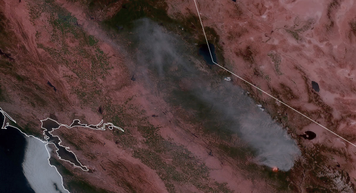
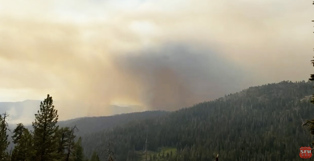
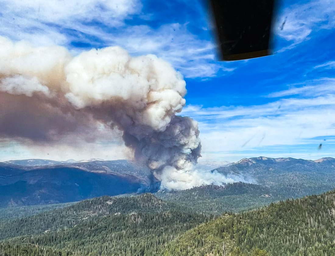
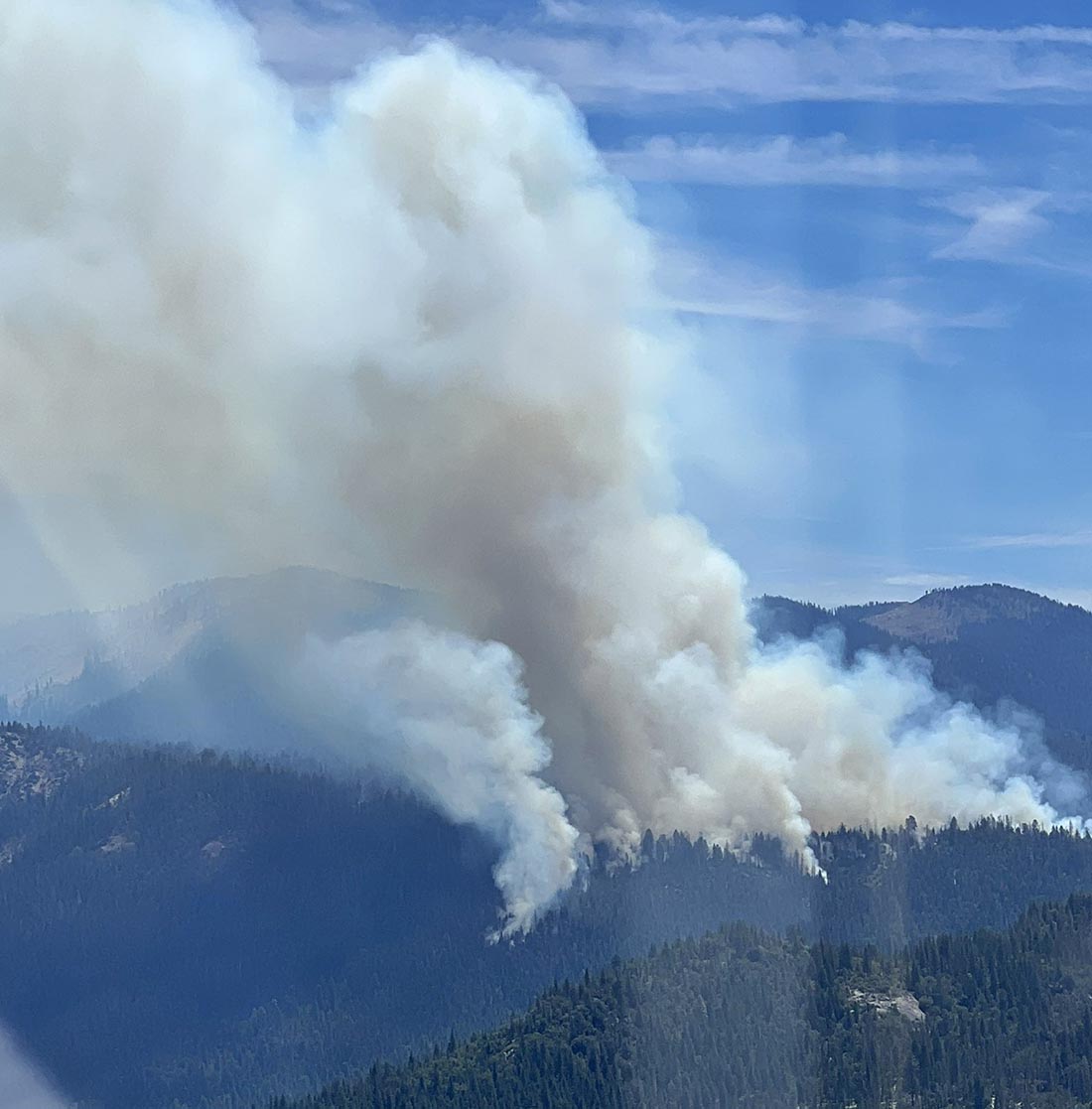
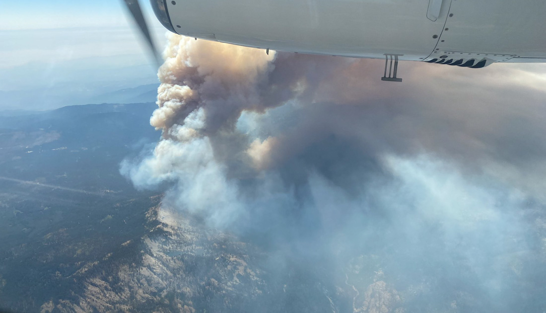
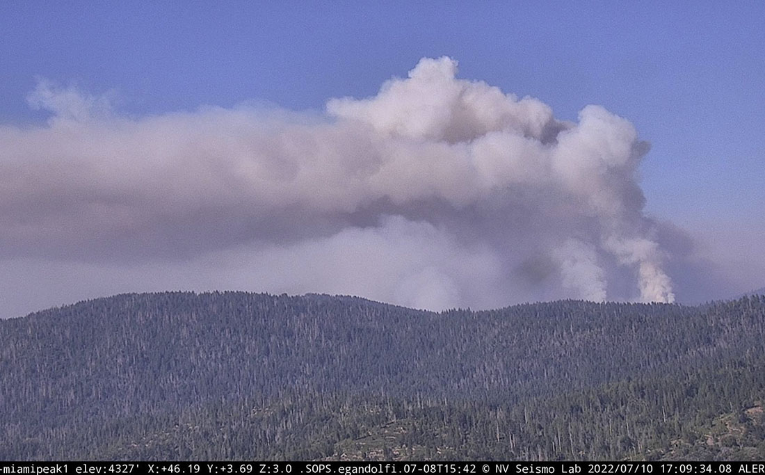
Late in the afternoon the fire activity increased substantially, sending up a substantial smoke column which was blown off to the north.


9:11 a.m. PDT July 10, 2022

Washburn Fire 3-D map 10 p.m. July 10, 2022
Washburn Fire, 3-D map looking west. The red line was the perimeter at 10 p.m. July 9, 2022. The white line was the perimeter 24 hours before.

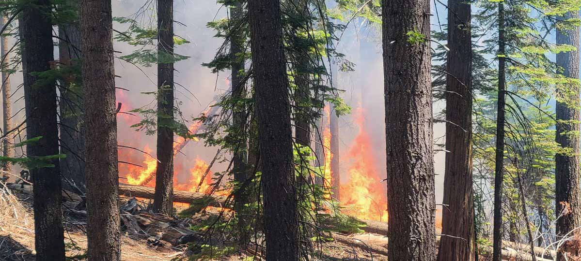
With very little wind Saturday, the Washburn Fire continued to spread in and adjacent to the Mariposa grove of giant sequoia trees in Yosemite National Park in California. In spite of the relatively mild weather conditions, spot fires are occurring hundreds of feet out in front of the leading edge. The growth into the grove has been limited due to previous prescribed fires that reduced the amount of fuel on the ground, and by the efforts of firefighters. Some of the trees are about 3,000 years old.

Firefighters set up sprinklers at Grizzly Giant sequoia fire
Firefighters set up sprinklers at the Grizzly Giant sequoia during the Washburn Fire in Yosemite National Park, July 9, 2022. NPS image.

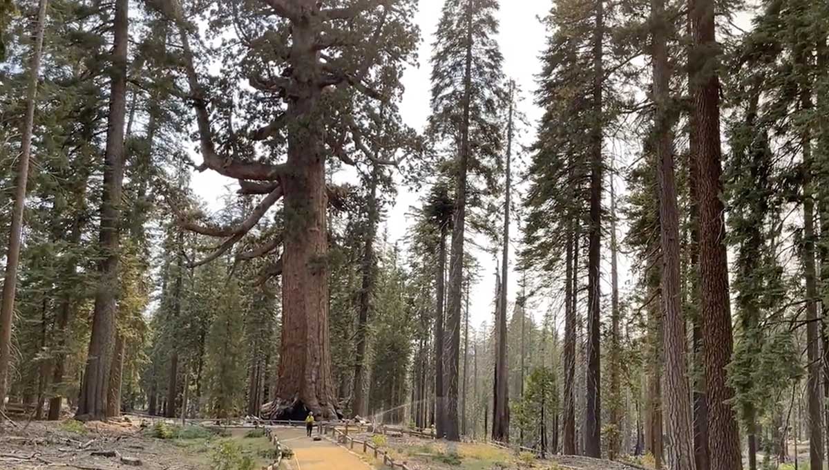
While the huge, very old trees are adapted to fire, they are not prepared for human caused climate change and the current “exceptional drought” conditions that have led to low soil and fuel moistures. The monster trees are more vulnerable to the existing weather and fuel conditions. They only grow in about 70 groves located on the western slopes of California’s Sierra Nevada Mountains. They are the largest trees on Earth in terms of volume.

The fire was mapped Friday night at 1,591 acres. Approximately 300 acres are in the Mariposa Grove of giant sequoias, on the west and north sides.

Smoke at times on Saturday degraded visibility to the point where retardant-dropping aircraft were grounded. Most of the movement of the fire was on the north end where it is working its way down-slope to the South Fork of the Merced River, which is also the southern edge of the South Fork Fire that burned 7,563 acres in 2017. The footprint of that 5-year-old fire scar will not stop the fire by itself, but there will be less resistance to control as it spreads through the lighter fuels.

Washburn Fire map 10 p.m. July 10, 2022
Washburn Fire map. The red line was the perimeter at 10 p.m. July 9, 2022. The white line was the perimeter 24 hours before.

The Washburn Fire is burning in mostly high load conifer litter with a heavy dead and down component as well as numerous standing dead trees.

There was very little wind on the fire Saturday and none overnight at Fish Camp, south of the fire and 1,000 feet lower where the minimum humidity Saturday was 31 percent but rose to 83 percent by 7:31 a.m. Sunday. Warmer and drier weather is predicted for the next few days.

The weather forecast for the fire area on Sunday calls for temperature around 80, relative humidity 26 percent, and ridgetop winds out of the west at 5 mph gusting to 12 mph in the afternoon. For Sunday night, 66 degrees, 33 percent RH, and 5 to 10 mph northwest winds in the evening shifting to east after 9 p.m.   Monday should bring 83 degrees, 20 percent RH, and 5 to 10 mph winds out of the southeast shifting to southwest by 11 a.m.

Washburn Fire 3-D map 10 p.m. July 10, 2022
Washburn Fire, 3-D map looking east. The red line was the perimeter at 10 p.m. July 9, 2022. The white line was the perimeter 24 hours before.

Fire burns into another giant sequoia grove, this time in Yosemite National Park

Washburn Fire has burned hundreds of acres in the Mariposa Giant Sequoia Grove

Updated at 5:26 p.m. PDT July 9, 2022

Washburn Fire at 5:24 p.m. July 9, 2022
Washburn Fire at 5:24 p.m. July 9, 2022. Sierra Fire Watch image.

Smoke over the Washburn Fire is preventing air tankers from dropping retardant.

The FIRIS mapping aircraft reported at about 4 p.m. that the fire had grown to 1,384 acres


Updated 8:03 a.m. PDT July 9, 2022

Map 3-D Washburn Fire Yosemite National Park 10 p.m. July 8, 2022
3-D map of the Washburn Fire in Yosemite National Park, looking east at 10 p.m. July 8, 2022.

The Washburn Fire in Yosemite National Park in California was very active throughout Friday night and into Saturday morning. The photo below taken at dawn on Saturday shows a convection column of smoke, something you don’t often see over a wildfire at dawn.

Washburn Fire, July 9, 2022
Washburn Fire, looking NNE from the Deadwood camera at 6:03 a.m. July 9, 2022.

The National Park Service, which often “manages” wildfires in Yosemite rather than aggressively putting them out, said they are fully suppressing this fire. California Interagency Incident Management Team 13 has assumed command, and additional firefighting resources will continue to arrive over the coming days.

A mapping flight at 10 p.m. Friday found that it had grown to 703 acres, a number that has no doubt been exceeded in the subsequent hours.

Map Washburn Fire Yosemite National Park 10 p.m. July 8, 2022
Map of the Washburn Fire in Yosemite National Park, 10 p.m. July 8, 2022.

The overnight weather at the Fish Camp weather station south of the fire 1,000 feet lower in elevation, recorded a maximum relative humidity of 53 percent and light winds out of the west and northwest. The spot weather forecast issued Friday afternoon predicted for Saturday 82 degrees, 27 percent relative humidity, and 6-12 mph afternoon ridgetop winds gusting to 18 mph out of the southwest and west. This should  influence the fire to continue spreading to the northeast and east.

Approximately 155 acres of the fire has burned into the west side of the 1,300-acre Mariposa giant sequoia grove. The Park Service has been conducting prescribed fires within the grove for years, including about seven since 1999. This should slow the spread in the grove and reduce the fire intensity compared to other locations that do not have similar recent fire history. It remains to be seen how much sequoia mortality will occur under the present low fuel moistures and “exceptional drought” conditions.

It appears likely that the blaze will reach the South Fork of the Merced River, the southern perimeter of the 2017 South Fork Fire, which should also slow the progression of the fire.

Washburn Fire, July 8, 2022
Washburn Fire, July 8, 2022. By @countryheli
Washburn Fire, July 8, 2022
Washburn Fire, July 8, 2022. By @countryheli

7:04 p.m. PDT July 8, 2022

Washburn Fire map, 2:42 p.m. July 8, 2022
Washburn Fire map. The dots represent heat detected by a satellite as late as 2:42 p.m. July 8, 2022. The red dots are the most current.

Another wildfire is burning in a grove of giant sequoia trees — behemoths that can live for 3,000 years. The Washburn fire was reported at 2 p.m. Thursday July 7 and by 4 p.m. Friday it had been mapped by a FIRIS aircraft at 466 acres. At least 150 acres of the fire are within the Mariposa giant sequoia grove in the south end of Yosemite National Park two miles southeast of Wawona, a community that is under an evacuation order. An evacuation map has been posted and the south entrance to the park is closed.

Preliminary surveys found that in a two year period, 2020 and 2021, almost 20 percent of all giant sequoias in their natural range over four feet in diameter were killed by fire (and neglect) or will die in the next few years. In 2020, 10 to 14 percent of the entire Sierra Nevada population of giant sequoia trees over 4 feet in diameter were killed in the Castle FireEarly estimates after two fires the following year, the KNP Complex and the Windy Fire, 2,261 to 3,637 sequoias over four feet in diameter were killed or will die within the next three to five years.

Washburn Fire, July 8, 2022
Washburn Fire, July 8, 2022. NPS photo.

Aircraft report that as the activity on the Washburn Fire increased Friday afternoon multiple spot fires occurred near the South Fork of the Merced River and east of Highway 41, some of them 0.7 miles out ahead of the main fire. That river was the south edge of the South Fork Fire that burned 7,563 acres in 2017. Normally a fire would slow down considerably when it encountered a fire scar less than 8 or 9 years old, but the Electra Fire near Jackson, CA burned quite well earlier this week in a seven year old scar. It will be interesting to see what the Washburn Fire will do if it bumps the South Fork Fire footprint.

Washburn Fire
Washburn Fire, looking north-northeast from the Deadwood AlertWildfire camera at 6:07 p.m. July 8, 2022.

The National Park Service has conducted four prescribed fires east of the Washburn Fire, in 2003, 2004, 2006, and 2016 for a total of 295 acres. This would have reduced some of the fuel in those areas, which may slow the spread in those treated locations, reduce the wildfire intensity, and the mortality of the giant sequoias. The more recent treatments are the most effective for modifying the behavior of a wildfire.

Washburn Fire, fuel treatments
Washburn Fire, fuel treatments. There have been other fuel treatments in the Mariposa Grove not shown on this map.
Washburn Fire
Washburn Fire, as seen from a firefighting helicopter. Photo by @countryheli July 8, 2022.
Washburn Fire shortly after it was discovered, July 7, 2022
Washburn Fire shortly after it was discovered, July 7, 2022. NPS photo.

Information about the Mariposa grove of giant sequoia, from Yosemite Mariposa County:

The most famous tree in the grove is the Grizzly Giant, one of the largest trees in the Mariposa Grove and, at an estimated age of 2,700 years, one of the oldest living sequoia.

Beyond the Grizzly Giant sit hundreds of lesser-visited sequoias in the upper grove including the Clothespin Tree, the Faithful Couple and the fallen Wawona Tunnel Tree.

Yosemite National Park closed due to damage from strong winds

Structures and vehicles were damaged

Yosemite NP wind damage
Yosemite NP wind damage, Jan. 19, 2021. NPS photo by Lindsay Stevenson

Very strong winds Tuesday morning January 19 blew down numerous large trees in Yosemite National Park causing significant damage to structures and vehicles. Photos show crushed pickup trucks, a damaged front end loader, and an impacted structure. A tree that was adjacent to a road damaged a road and a culvert as the roots tore through the pavement as it blew over. Power lines were also affected.

The park was closed Tuesday and will likely remain closed until Friday morning, the park announced, as employees conduct damage assessments, repair facilities, and clear trees. Thankfully no injuries have been reported as a result of the strong winds.

One of the photos showing a damaged structure was taken at Wawona south of Foresta.

A weather station at Crane Flat north of Forresta recorded a 53 mph wind gust Tuesday morning, while 35 mph gusts occurred at both Wawona and El Portal.

Yosemite NP wind damage
Yosemite NP wind damage, Jan. 19, 2021. NPS photo by Lindsay Stevenson
Yosemite NP wind damage
Building in Wawona damaged by tree that fell during Mono winds on January 19, 2021.. NPS photo by Lindsay Stevenson
Yosemite NP wind damage
Yosemite NP wind damage, Jan. 19, 2021. NPS photo by Lindsay Stevenson
Yosemite NP wind damage
Yosemite NP wind damage, Jan. 19, 2021. NPS photo by Lindsay Stevenson

Flyover tour of Ferguson Fire at Yosemite National Park

Take a simulated flight over the 89,000-acre wildfire

Above: screenshot from the video.

This is a flyover virtual tour of the Ferguson Fire burning in and near Yosemite National Park in California. The red line was the perimeter at 12:15 a.m. PDT August 5, 2018. The red shaded areas were intense heat at that time. The blue line is the location of the huge Rim Fire of 2013. The green line is the boundary between Yosemite National Park and U.S. Forest Service managed land. Recorded by WildfireToday.com August 5, 2018.

The fire has burned over 89,000 acres in Yosemite National Park, Sierra National Forest, and Stanislaus National Forest. On the north edge it has burned into the footprint of the Rim Fire that blackened 257,000 acres in 2013.

(To see all articles on Wildfire Today about the Ferguson Fire, including the most recent, click HERE.)

Ferguson Fire spreads across Highway 41, moves deeper into Yosemite

The fire is well established on the east side of Highway 41 and has crossed Glacier Point Road

(UPDATED at 5:20 a.m. PDT August 4, 2018)

map Ferguson Fire
Map showing the perimeter of the Ferguson Fire at 1:30 a.m. PDT August 4, 2018. The red shaded areas represent intense heat at that time. The blue line at the top is the 2013 Rim Fire. Click to enlarge.

These two maps of the Ferguson Fire at Yosemite National Park in California include the latest perimeter data collected by a fixed wing aircraft at 1:30 a.m. PDT August 4, 2018.

Friday afternoon the fire spotted across two highways running for almost a mile in both places — east of Highway 41 at Glacier Point Road, and across Highway 140 below Foresta. The slop over across 41 was approximately 200 acres at 1:30 a.m. PDT on Saturday. About half of that crossed over Glacier Point Road.

map Ferguson Fire
Map showing the northeast perimeter of the Ferguson Fire at 1:30 a.m. PDT August 4, 2018. The red shaded areas represent intense heat at that time. Click to enlarge.

Below is an excerpt from a Friday evening update by the incident management team:

The Ferguson Fire grew by 3,647 acres throughout the day and was at 77,207 acres as of 6 p.m. Containment is at 41 percent. Firefighters worked throughout the day on a spot fire that jumped the Merced River early this morning and is burning in the Crane Creek drainage southwest of Foresta. Aircraft dropped water and retardant in support of firefighters.

Bulldozers and hand crews built containment lines between the fire and Foresta. Engines and crews remained in Foresta for structure protection. While Yosemite Valley was not in imminent danger, dangerous road conditions, smoke and a loss of power prompted Yosemite National Park officials to evacuate the area until further notice.

Later in the afternoon, another spot fire emerged west of Wawona Road (Highway 41) and began advancing toward Badger Pass. Evacuations were issued along Highway 140 out of concern that shifting winds overnight could bring the fire back into the communities.

On the north side of the fire, crews completed tactical firing along Pilot Ridge on the Mariposa-Tuolumne county line. They will perform firing operations south along the 13 Road as weather allows to fully contain the fire’s northern perimeter.

(To see all articles on Wildfire Today about the Ferguson Fire, including the most recent, click HERE.)


(UPDATED at 7:17 p.m. PDT August 3, 2018)

map Ferguson Fire
The satellite heat sensing data from 2:43 p.m. PDT August 3, 2018, represented by the red dots, can be seen in the map above.

The satellite heat sensing data from 2:43 p.m. PDT August 3, 2018, represented by the red dots, can be seen in the map above. It shows heat where the Ferguson Fire, at Yosemite National Park in California, crossed Highway 41 near Glacier Point Road, and Highway 140 south and southeast of Foresta.

We hope to have an updated map Saturday morning. Continue reading “Ferguson Fire spreads across Highway 41, moves deeper into Yosemite”

TBT: Fire effects in Yosemite NP, 1897

For Throwback Thursday we’re throwing WAY back, to 1897. This photo shows Yosemite National Park Superintendent Capt. Alex Rogers standing next to a fire-scarred tree near Tioga Road in September, 1897.

Photo courtesy of the U.S. Geological Survey.