Social media can help identify evacuation patterns

Data can help determine when people relocate in or out of an evacuation area

social media evacuation pattern Ranch Fire wildfire
August 5, 2018

In July 2018, a spark near the Mendocino National Forest ignited California’s largest wildfire on record. As the Ranch Fire spread rapidly, officials declared mandatory evacuations in several areas and counties. But where did people go, when did they leave, and when did they return? Researchers have turned to a new data source to observe population movements during a crisis: social media.

“We wanted to analyze evacuation patterns and factors that can influence the speed of evacuations during a crisis,” said Shenyue Jia, a remote sensing specialist at Chapman University.

Analyzing evacuation and recovery patterns could help researchers understand how humans behave in the face of a disaster, which could inform emergency response efforts. Jia said nobody was able to provide population movements during a disaster, especially at a high temporal and spatial resolution—until Facebook.

Almost 2.5 billion people per month actively use Facebook. When a disaster strikes, many of those users log on during an evacuation. Facebook’s disasters map initiative uses aggregated, anonymized Facebook data in disaster areas to estimate population densities, movements between neighborhoods, and where people mark themselves as “safe” during a crisis. The company also works with mobile phone carriers to observe the number of connections to surrounding cell phone towers.
social media evacuation pattern Ranch Fire wildfire
August 8, 2018

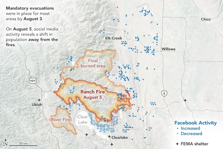
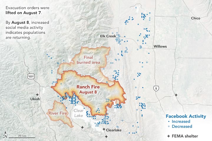
The images on this page show the population data during the Mendocino Complex Fire in Northern California for 10,000 people, as provided by the Facebook disaster map dataset. The first map above shows the area on August 5, 2018, two days after mandatory evacuations were in place. The second map below shows the area on August 8, one day after the evacuation orders were lifted.

During the Mendocino Complex fire, most people fled the fire perimeter when an evacuation was in place, which was not surprising. But what surprised Jia was where people were headed—or not headed.

“Originally, I thought this data could be nice to track which places people decide to go, but the information didn’t show any significant pattern for this fire,” said Jia, whose research was funded by NASA. “I was expecting a very simple trend, but evacuations are more complicated to understand.”

Jia thinks that perhaps people had more shelter options to flee to (FEMA shelters, neighboring towns, etc.), so the evacuation patterns were dispersed.

However, when the evacuations were lifted, the data showed a much clearer trend of where people were headed: most were returning back to their homes and hometowns. Jia said that how the population bounces back post-disaster is an important indicator of whether the evacuated areas may be safe for residing. In the Mendocino Complex fire, most areas saw people returning.

But that’s not always the case. Jia also analyzed population data from Facebook for the Camp Fire that occurred in November 2018. The data showed a large portion of the evacuated area did not see a sustainable population return since many of those areas were destroyed.

“This research demonstrates that social-network data can be a valuable tool to monitor human behaviors in response to disasters, such as wildfires in areas that have been exacerbated by urbanization,” said Son Nghiem, remote sensing expert at NASA’s Jet Propulsion Laboratory, who oversaw this research.

According to Nghiem, this frequently updated social media data can add another dimension to satellite remote sensing data from NASA and other international agencies used to monitor land cover and land use change.

“With remote sensing data, we don’t know the immediate socioeconomic and demographic impacts,” said Nghiem. “This innovative use of demographic data opens up new possibilities to advance research on how humans respond to abrupt physical changes in disaster situations.”

This article first appeared on the NASA website. NASA Earth Observatory images by Joshua Stevens, using data courtesy of Shenyue Jia/Chapman University. Story by Kasha Patel.

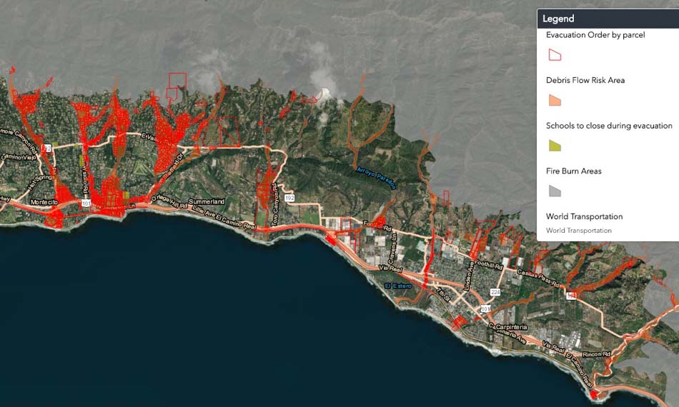
Thousands told to evacuate below burn scars in Santa Barbara area as heavy rain is predicted

The evacuation order begins at 10 a.m. January 15

Fire debris flow flooding Santa Barbara evacuation map
Map showing areas under evacuation orders beginning at 10 a.m. January 15, 2019. Santa Barbara County. Click to enlarge.

Three to four thousand residents in areas below the footprints of three recent fires in Southern California’s Santa Barbara County have been ordered to evacuate as a winter storm approaches which could lead to debris flows below the Sherpa, Whittier, and Thomas fires burn areas. The evacuation order is in effect beginning at 10 a.m. Tuesday January 15.

Thomas Fire debris flow flooding
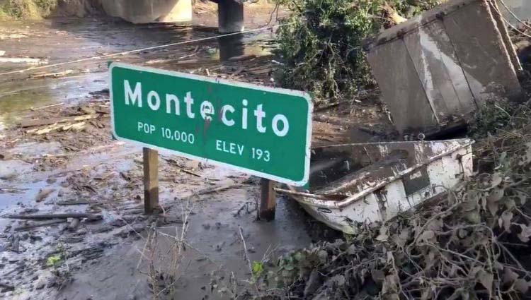
Mud and debris flow in Montecito below the Thomas Fire, January 9, 2018. Photo by Mike Eliason, Santa Barbara FD.

Santa Barbara County has more information about the evacuation, including a map. A Red Cross shelter will be open at 10 a.m. at Goleta Valley Community Center, 5679 Hollister Ave., Goleta. Two schools are closed and three are holding classes at alternative sites.

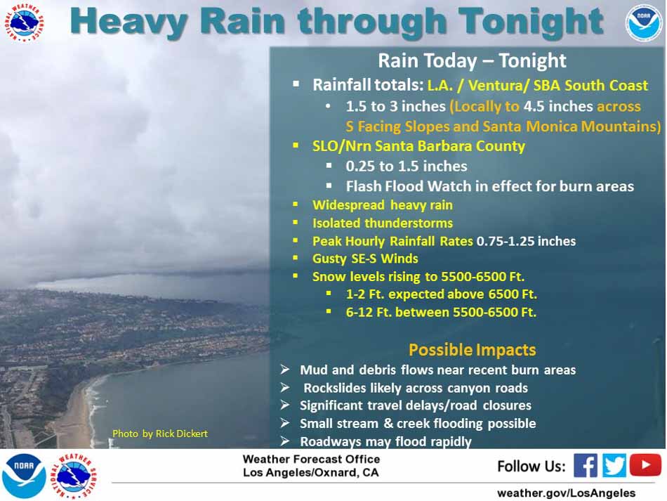
The National Weather Service is predicting 1.5 to 3 inches of rain in the Santa Barbara area with up to 4.5 inches locally on south-facing slopes. Peak hourly rainfall rates could reach 0.75 to 1.25 inches. The heavy rain should taper off Tuesday night, followed by showers on Wednesday which will increase to heavy rain again Wednesday night.

Fire debris flow flooding Santa Barbara

Evacuation alerts face scrutiny as California wine country wildfires rage

(Above: A firefighter works in Northern California. Photo courtesy CAL FIRE). 

It was only a matter of time.

As follows almost every major natural disaster in recent years, emergency officials are under fire for what some say was lackluster performance when it came to warning people about the oncoming siege of fire marching toward their homes early Monday.

Why weren’t more cell phone alerts issued?

Why wasn’t there more advance notice?

What worked, and what didn’t?

With at least 31 lives lost as a result of the fast-moving fires across Northern California’s wine country, they’re fair questions — questions that will no doubt come to dominate the conversation in coming weeks and months.

But while there are always things to learn from, it is worth remembering this was not a disaster that had a days-long build-up, like a hurricane. For many near the point of origin, there wasn’t even an hours-long build up, like severe weather such as tornadoes. Rather, many families went to bed Sunday before any fires had ignited, only to be awoken in the middle of the night to commands from a loudspeaker outside, a neighbor pounding on the door, or — maybe — a telephone call.

As it relates to messaging, here’s a rundown of what we know:

  • Officials did not issue Amber-Alert-style cell phone messages in Napa and Sonoma counties. These alerts, administered through the Wireless Emergency Alert System, light up cell phones and trigger an un-mistakable screeching sound when a child is missing and in danger in the recipient’s area. Though they are almost guaranteed to wake people from a dead sleep, they are not necessarily intended for neighborhood-level evacuations.

According to the FCC, the alerts are broadcast from cell towers whose coverage area best matches the zone of an emergency to “phones that are using the cell towers in the alert zone.” Depending on the region and how connected residents are to cell phone networks, that could result in a widespread, wide-radius of messaging.

And that could have resulted in a widespread shadow evacuation in which everyone — not just those in immediate evacuation zones — hits the roads in the middle of the night in a panic, potentially leading to any number of other emergencies, officials maintain. 

“It would cause unnecessary evacuations and delays for emergency vehicles reaching people in areas in need,” said county spokeswoman Jennifer Larocque, according to The Mercury News. “In order not to slow down response to people actually in need of help, we chose not to send the notice.”

Though beneficial, residents have to register for the service, a quick process but a process nonetheless. And there remains the challenge of reaching people in the middle of the night, as was the case this week.

It seems pertinent here to mention media, both social and traditional. Though news reporters were quick to begin reporting on the fires, and many were on the fire line overnight, residents were likely slow to tune in, at least initially. And social media, the means through which many community-level communications are handled by way of Facebook or NextDoor, was a vacuum at first. If you posted something, it might not have been seen until the morning.

  • So that leaves word-of-mouth. There are scores of harrowing stories of neighbors warning neighbors, showing up on doorsteps, blaring horns and doing everything they could to simply get people to wake up and look outside. This was how many people learned of the urgency. This, many have said, was the best way to get the word out.

“The smoke and ash and embers were raining down, sparking spot fires,” Paul Lowenthal, assistant fire marshal in Santa Rosa, recalled in an interview Wednesday with The Washington Post. “It didn’t take but moments for people to look out their front doors and see what was happening.”

It’s less than ideal. But in some cases, it’s all there can be.

As an aside, my graduate research was about evacuation communications during the 2013 Colorado Flood, which devastated a swath of the state and carved communities into islands. The gist: social ties matter within a community during disaster events. And while technology can certainly help, it cannot be the only answer, nor can it be the answer without considering the role of local first responders. People go through a two-step process during evacuations: hearing an alert and seeking additional information. It is inherently a social experience. Accordingly, communication infrastructure is vital as people both receive initial information and seek additional details, through whatever means necessary discussed earlier in this piece.

All of that to say cell phone towers becoming compromised during a disaster — as was the case during this week’s wildfire outbreak — will no doubt be a topic officials hone in on, with good reason.

In March, I wrote a piece for Wildfire Today about issues continuing to play out surrounding evacuations in Gatlinburg, a starkly different situation, but relevant still. Essentially, city officials there, it was determined, downplayed the threat early in the incident. Then, when hurricane-force winds tore through the region and fanned the flames, a “communication failure” caused by disabled communication services prevented the immediate issuance of a timely alert. Alternative sources of emergency communication — local media, for example — had only a marginal effect.

It’s only been five days since fires in Northern California erupted. The questions, after-actions reviews and analyses will be long coming.

Communicating breaking news or public safety-related evacuation messages to off-line, at-risk populations during a dynamic disaster event is a seemingly impossible conundrum. It is one that researchers have spent decades studying in various forms, whether under the umbrella of the sociology of disaster or the various hazard communication models within emergency management.

Going forward, with a continuous onslaught of disasters now reality, it’s an area that should not be ignored.

Station Fire burns homes and at least 7,000 acres near Casper, Wyoming

Cole Creek Fire
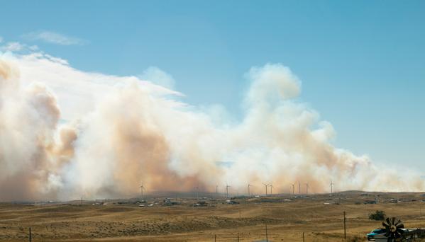
Station Fire near Evansville, WY, Oct. 11, 2015. Photo by MyWyomingAdventure

The Station Fire has burned approximately 16 homes and 9,000 acres just east of Casper, Wyoming in the community of Evansville. It started in a landfill on the north edge of town Saturday afternoon during a strong wind event, laid down overnight, but took off again Sunday afternoon. At 3:15 p.m. Monday, Wyoming State Forester Bill Crapster said the fire had been mapped at 7,000 Monday morning, but strong winds later in the day caused it to continue spreading and he estimated it had grown to about 9,000 acres.

Mr. Crapster said 536 homes are under evacuation orders affecting 1,350 residents. Two large air tankers assisted the ground-based firefighters. The MD-87 and BAe-146 were reloading at Rocky Mountain Metropolitan Airport (JeffCo) 219 miles southeast of the fire.

He confirmed the name of the fire is Station, in spite of media reports calling it the Cole Creek Fire.

Map Cole Creek Fire
Map showing heat detected by a satellite over the Station Fire up through 11:36 a.m., October 12, 2015. The dots represent heat, but most of the vegetation is grass which can burn and then cool off before the next satellite overflight.

Two helicopters are working the fire, a Type 1 and a Type 3, in addition to 50 to 60 engines, Mr. Crapster said.

While returning from a motorcycle trip to the national parks in northwest Wyoming Saturday evening, we happened to stop overnight in Evansville at a hotel 1.8 miles southeast of the burning landfill. As the sun was setting we watched the fire which was burning vigorously in the landfill and had spread a bit beyond it. Sunday morning as we left at 8 a.m. we did not notice any smoke there at all.

But the wind in the area Saturday night and Sunday morning was very, very strong, steady at 30 mph at least, with much stronger gusts. I was worried about the wind Saturday night blowing over my 600-pound bike in the hotel parking lot. When I checked in, the desk clerk noticed my attire, asked if I was on a motorcycle, and said that because of the wind I could park it near the front door … which I did. Thankfully it was still upright Sunday morning. As I departed the area on Interstate 25 heading east and then south there was an electronic sign over the Interstate warning of winds gusting to 55 mph, and said light trailers should not attempt travel. It was a battle on the motorcycle trying to stay in only one lane as I was rudely pushed around by the very, very strong wind.

The RAWS weather station at Fales Rock west of Casper recorded a wind gust Sunday morning of 61 mph with sustained winds above 30 mph between 8 a.m. and 2 p.m. By afternoon the relative humidity dropped to 10 percent.

At 3:10 p.m. on Monday the Fales Rock station showed 69 degrees, RH of 13 percent, and a southwest wind of 16 mph gusting to 27.

The weather forecast for the fire area calls for southwest winds decreasing Monday night to 17 mph with gusts to 24, an overnight RH of 42 percent and a low temperature of 44 degrees. Tuesday should bring 73 degrees, winds out of the southwest at 13 gusting around 20, and an RH of 14 percent.

UPDATE  December 22, 2015: The Star Tribune has more information about how the fire started and how the initial attempts by landfill personnel to suppress the fire were not successful. The correct name of the fire is Station, not Cole Creek.

A fire that destroyed 14 homes in rural Evansville began after smoldering debris from a grinder at the Casper landfill ignited a woodchip pile at the facility, a state report concluded.

High winds the following day spread the embers to the surrounding prairie, sparking the Cole Creek Fire, which burned over 10,000 acres and temporarily displaced more than 1,000 people in October.

Landfill workers tried twice to extinguish the smoldering debris from the grinder, first with water extinguishers and later by stomping on them, according to the report, which was produced by the Wyoming Department of Fire Prevention and Electrical Safety.

The debris was pushed back into the woodchip pile after the second attempt by employees who believed the debris was no longer burning. However, the debris was still smoldering and ignited wood in the brush pile. Firefighters responded and kept watch overnight but lost control of the fire the following afternoon.

The report, which the Star-Tribune obtained Monday using a public records request, concludes the fire was an accident. The document does not address whether any workers at the landfill acted negligently….

Wildfire briefing, March 24, 2014

Research: global wildfires did not kill the dinosaurs

Contrary to what other researchers concluded, a new study revealed that an asteroid that hit the Earth 65 million years ago on the Yucatan Peninsula in Mexico did not cause global wildfires that wiped out the dinosaurs. The first study led scientists to think that the impact raised temperatures to 1,000 degrees C, igniting global wildfires that killed most organisms.

The latest research team from Royal Holloway, University of London, led by Claire Belcher, concluded that “…the amounts of thermal radiation released by the impact of an asteroid with the Earth 65 million years ago, were not as significant as previously thought, and the energy component of the K-T event was not responsible for the extinctions seen at this time”.

Research: Understanding evacuation preferences and wildfire mitigations among Northwest Montana residents

The paper with the above title, written by Travis Paveglio, Tony Prato, Douglas Dalenberg, and Tyron Venn, employees who work at state Universities in Idaho, Missouri, and Montana, is available for taxpayers to read if they pay $25 to an organization in Australia.

Public Service Announcements about wildfire

An organization in Nevada has produced and released nine 31-second public service announcements about wildfire evacuation and defensible space. The list is HERE, and below is an example:

Colorado state Senator has second thoughts about bill that would have limited agricultural burning

A Colorado state Senator who introduced a bill that would allow county commissioners to ban agricultural burning and campfires when fire danger is high has had second thoughts and now wants to pull the bill. Senator Larry Crowder from Alamosa, under pressure from farmers, said Friday that there could be a possibility of county officials over using the power. The bill already passed the House by a 36 to 27 vote on February 14.

A tweet from Smokey Bear

Tweets about a fire in Capetown, South Africa

(Hopefully the photos will appear below. Sometimes they do, and sometimes they don’t.)

Authorities in Australia recommend evacuation due to “catastrophic” fire danger

NSW fire danger January 8, 2013
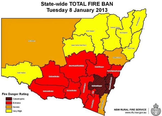
New South Wales fire danger predicted for January 8, 2013

As we write this at about 11 a.m. Mountain Time in the United States, the sun will be rising in an hour Tuesday morning in New South Wales, Australia. Residents there will experience a day that could have the most extreme fire danger ever recorded. Predictions in the state for Tuesday range from Very High to Catastrophic.

Australia’s ABC News reports that Rural Fire Service (RFS) Commissioner Shane Fitzsimmons said:

Catastrophic fire danger ratings are the worst you can get. We are talking about the most extreme fire behaviour – destruction is likely. We will see ember showers likely to be thrown 10 kilometres, if not 20 kilometres ahead, under the extraordinary conditions being forecast. We are looking at widespread areas of New South Wales likely to experience very high, severe, and even catastrophic conditions.

We’ve got 91 different fires … there’s a lot of work with firefighters on the ground at the moment – more than 650 firefighters working across those fire grounds, looking to bring those fires under control as much as possible.

About 20 of those 91 fires are not under control.

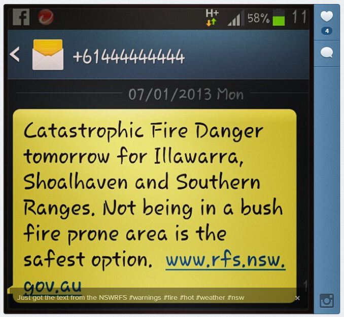
Here is the text of an emergency alert telephone message, a SMS, that was sent to the Illawarra, Shoalhaven, and Southern Ranges regions Monday night ahead of a 43C (109F) temperature forecast, recommending people escape while they can.

If you have received this message you are in an area that is forecast to have Catastrophic Fire Danger on Tuesday 8 January 2013.

For your survival, leaving early is the safest option. Leaving a bush fire prone area tonight or early tomorrow morning is recommended.

Make a decision about when you will leave, where you will go and how you will get there. Homes are not designed to withstand fires in catastrophic conditions.

Below is a screen capture from a cell phone of another similar message sent out by the RFS on Monday, January 7:

NSW RFS fire danger warning
Matt_1110 posted to Instagram this screen capture from his cell phone with a slightly different message, also from the RFS.

In my experience, this is unprecedented, at least in the United States, recommending that residents evacuate based on predicted fire danger — an example of proactive, forward-leaning leadership. If large, damaging fires erupt, the leaders will be praised as heroes. If not, there may be criticism.

The Premier, Barry O’Farrel, is also getting involved, and was quoted at ABC News as saying:

[It] is not going to be just another ordinary day. [It could] be perhaps the worst fire danger day this state has ever faced. If Sydney reaches 43C [109F] [Tuesday], it will only be the third time in the history of record keeping that the temperature in Sydney has been that high.

Last month we wrote an article at Fire Aviation which detailed the aviation resources that were going to be available in Victoria this 2012-2013 fire season down under. Last year they leased two CV-580 air tankers from Conair, but this year it appears there are no large air tankers in Victoria. UPDATE: The Australian states and territories each operate or contract for their own firefighting aircraft, but they are shared across lines as needed. This fire season among all the states there are no large air tankers, but they have 14 small single engine air tankers and 35 helicopters which are used for various purposes.

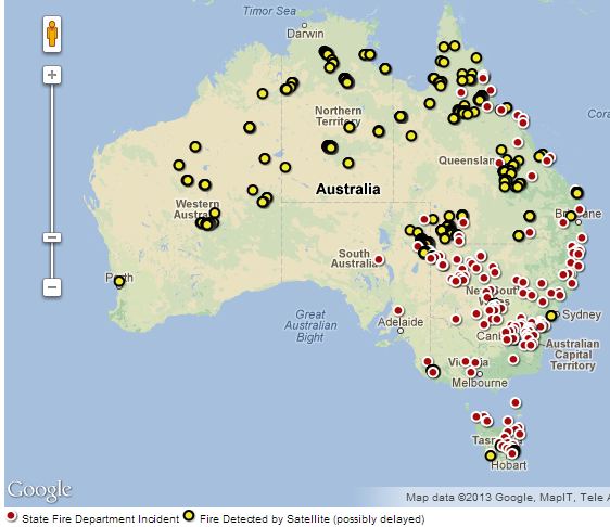
Current fires in Australia


Thanks go out to Dick and Kelly.