Mill Fire prompts evacuations in Weed, California

Multiple structures have been destroyed. A second fire, the Mountain Fire, is burning 12 miles west of Weed.

Updated at 8:30 p.m. PDT Sept. 3, 2022

Mill Fire

At 7 p.m. Saturday CAL FIRE reported that damage assessment imagery indicates 132 structures have been affected by the Mill Fire. This includes all structures of any kind including outbuildings that were damaged or destroyed. On Sunday damage assessment teams will begin ground truthing the data. The size has been updated to 4,254 acres and about 1,000 residents have been evacuated.

Mountain Fire

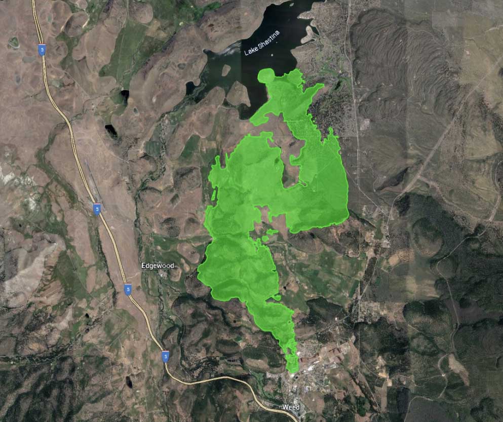
Also at 7 p.m. CAL FIRE said the Mountain Fire east of Weed, CA has burned 4,812 acres. There have been no reports of destroyed structures and 690 remain threatened. Approximately 332 people have been evacuated.

At 4 p.m. on Saturday CAL FIRE Incident Management Team 5 assumed command of both fires.


Updated 4:31 p.m. PDT Sept. 3, 2022

The Sacramento Bee is reporting that 100 homes have been destroyed in the Mill Fire, according to the Mayor and a CAL FIRE Unit Chief. Most of the homes were in the Lincoln Height area.

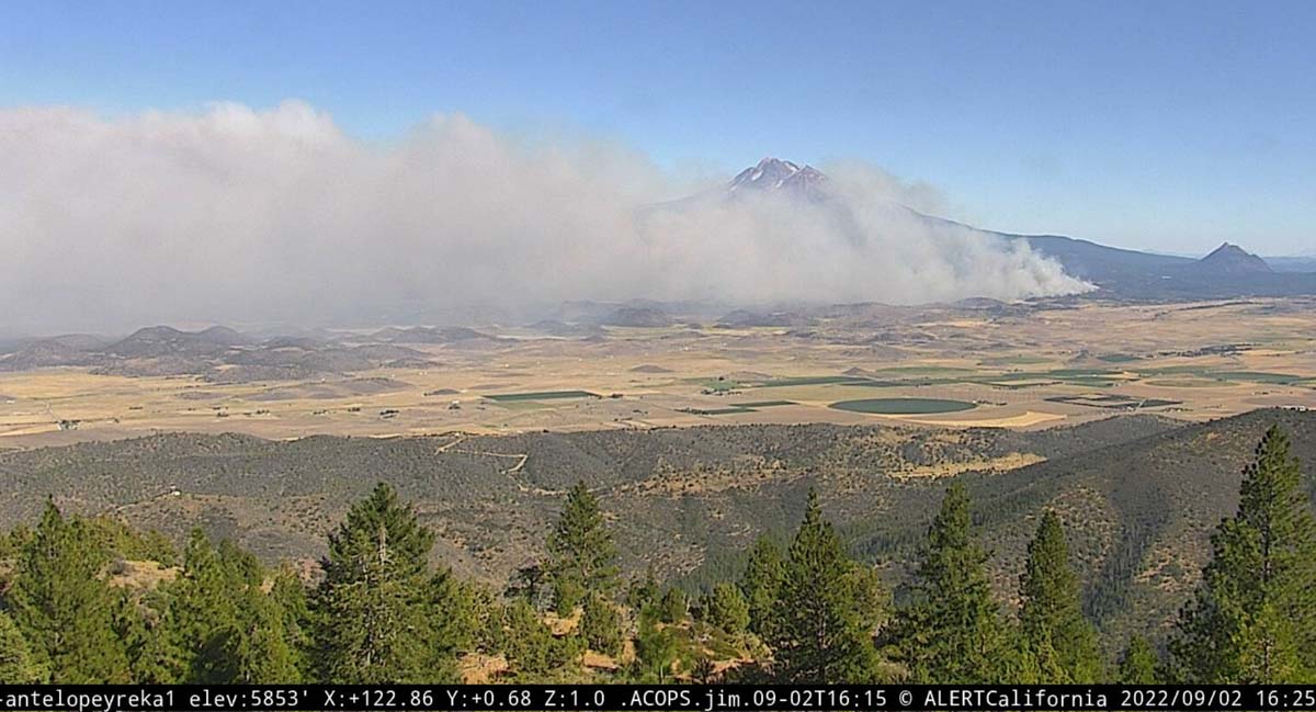
The nearby Mountain Fire is smoked in, making it impossible for firefighting aircraft to work.

NOAA aircraft over Mountain Fire
NOAA aircraft over Mountain Fire, 422 p.m. Sept. 3, 2022. FlightRadar24.

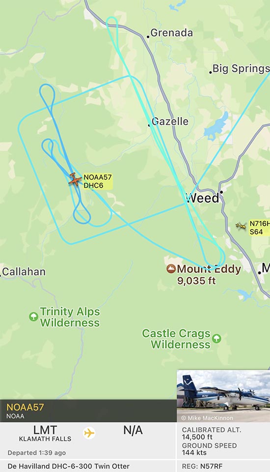
However, there is a NOAA Twin Otter aircraft flying an interesting square pattern over the fire at 14,500 feet. It may be collecting smoke or air quality data.


Updated 7:22 a.m. PDT Sept. 3, 2022

Map of the Mountain and Mill Fires
Map of the Mountain and Mill Fires 3:02 a.m. Sept. 3, 2022.

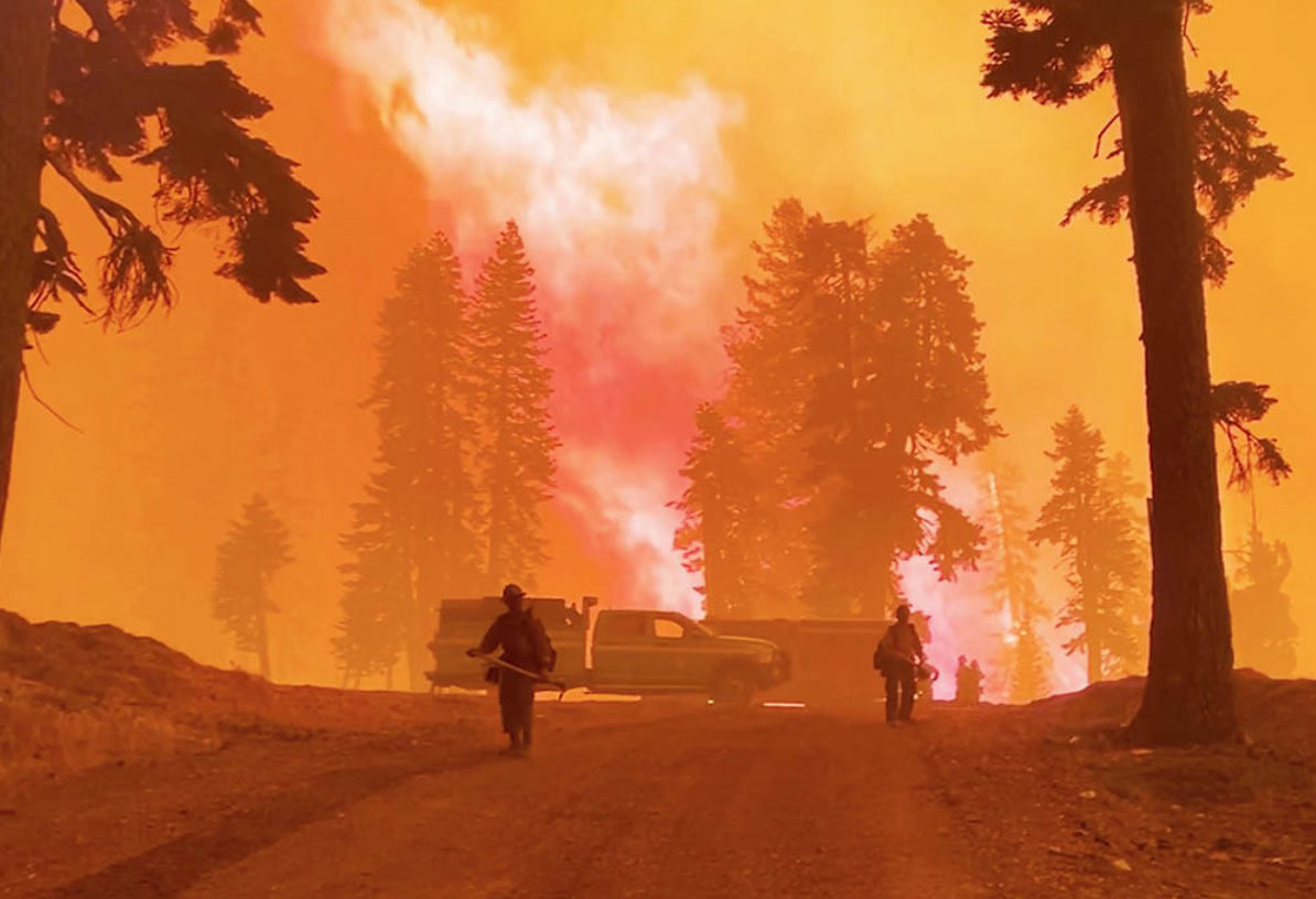
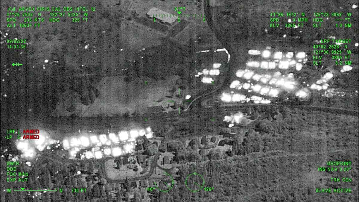
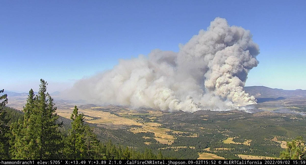
The 3,921-acre Mill Fire has destroyed multiple structures in the town of Weed, 56 air miles north of Redding California. Videos posted online showed residential areas burning as well as one industrial building. Thermal imagery recorded by the FIRIS mapping aircraft showed intense heat at the site of dozens of structures.

Map showing heat detected by the FIRIS aircraft at the Mill Fire
Map showing heat (white areas) detected by the FIRIS aircraft at the Mill Fire at 2:01 p.m. Sept. 2, 2022.

The spread of the Mill Fire slowed overnight as the winds that were gusting at more than 20 mph hour Friday afternoon decreased to 4 mph after midnight and the relative humidity rose to 54 percent.

The Mayor of Weed told the LA Times that the fire appeared to have started at a lumber mill near the town.

Suzi Brady, a CAL FIRE spokeswoman, said several people were injured. At least two were treated at hospitals, NPR reported.

Another fire in the area, the Mountain Fire, was very active through the night. It has spread about five miles north since it started near Gazelle Callahan Road 12 air miles west of Weed. It is about 6 miles southwest of Gazelle. CAL FIRE reports it has burned 1,464 acres, but current unofficial estimates put it more than double that figure.

Both fires are burning primarily on private land, but the Mountain Fire started near the boundary of the Shasta-Trinity National Forest and burned some of the Forest east of Gazelle Callahan Road.

Map of the Mountain and Mill Fires
Map of the Mountain and Mill Fires by the FIRIS aircraft, ~5:49 a.m. Sept. 3, 2022.

The Mill Fire has light fuel loadings out ahead, and to the east is the burn scar of last year’s 26,000-acre Lava Fire.

The Mountain Fire on the other hand is surrounded by private timber land with no significant recorded history of fire in the National Interagency Fire Center database. However that database is often lacking complete information. It has the potential for growth in all directions, including through numerous clear cuts with dry, light to medium flashy fuel.


Updated 9:32 p.m. PDT Sept. 2, 2022

Mill Fire map
Mill Fire, FIRIS map at 8:10 p.m. PDT Sept. 2, 2022.

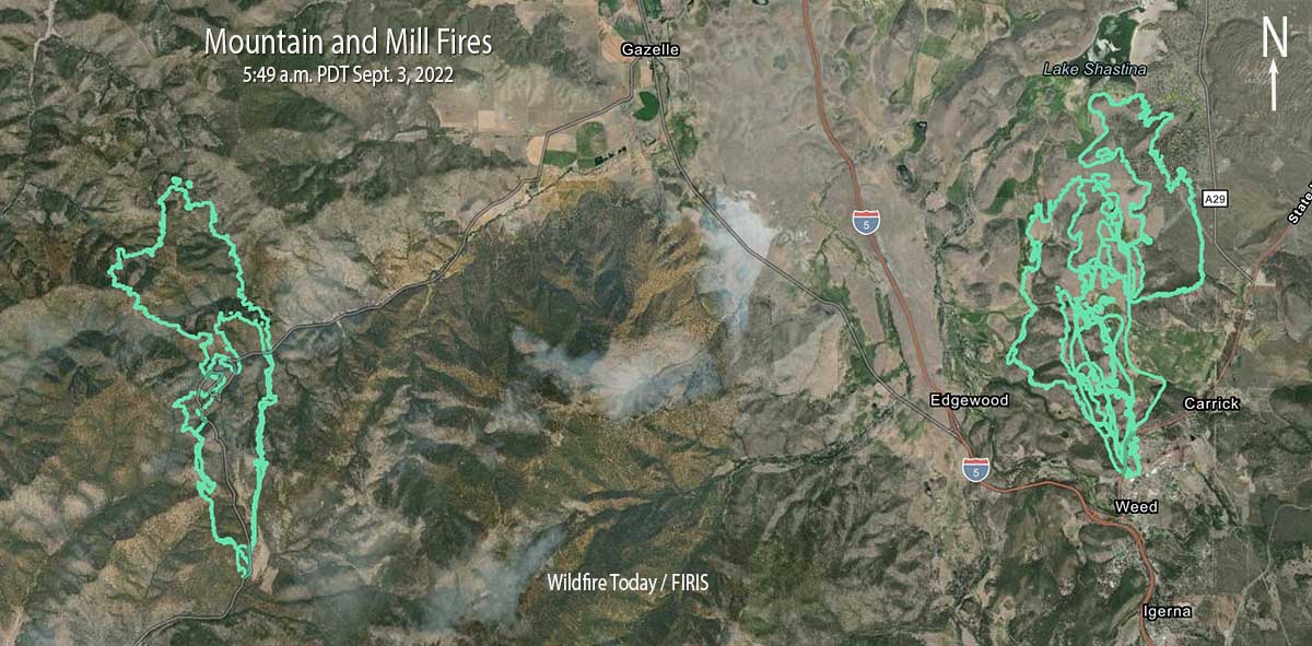
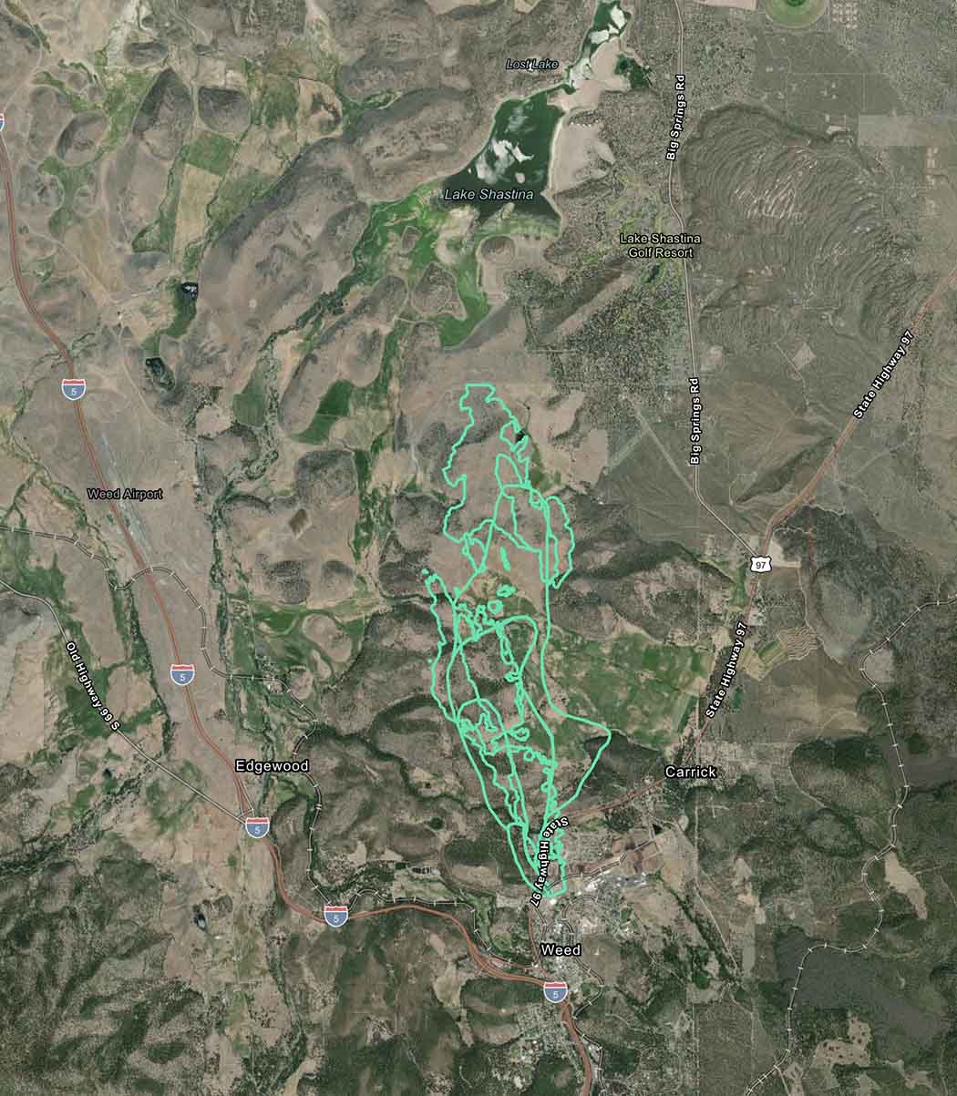
At about 8:10 p.m. the FIRIS aircraft mapped the Mill Fire at 3,921 acres, showing that it had burned from Weed, California north to the shore of Lake Shastina, a distance of nearly six miles.

The Mountain Fire 12 air miles west of Weed near Gazelle Callahan Road has burned approximately 700 acres. It is about 9 miles southwest of Gazelle.

Weather

Friday afternoon a weather station just southeast of Weed recorded 89 degrees, 7 percent relative humidity, and 12 mph winds gusting at 20 to 26 mph out of the east-southeast.

Friday night the winds should decrease to 5 to 10 mph out of the south after sunset, then decrease to 2 to 4 mph after midnight with a maximum RH of 45 percent.

The spot weather forecast for Saturday predicts 88 degrees, 12 percent RH, and winds out of the north at 1 to 3 mph.

The slower wind speeds should give firefighters a chance to put in some direct fireline on Saturday.


5:32 p.m. PDT Sept. 2, 2022

Map showing location of the Mill and Mountain Fires
Map showing location of the Mill and Mountain Fires, near Weed, California Sept. 2, 2022.

A fire reported at about 12:58 p.m. PDT is threatening structures in the town of Weed which is northwest of Mt. Shasta, 56 air miles north of Redding California.

The blaze is moving rapidly to the north. The southernmost end of the fire is near US Route 97 east of Interstate 5.

Map showing growth of the Mill Fire
Growth of the Mill Fire as tracked by FIRIS the afternoon of Sept. 2, 2022; time uncertain. The fire has grown substantially since this map was created.

Evacuations are in effect; the details and a map are at Zonehaven.

The last size released was 1,228 acres, but the blaze has grown substantially since then.

Mill Fire
Mill Fire, looking north-northeast from the Hammond Ranch camera at 3:59 p.m. Sept. 2, 2022.

There are widespread power outages in the area which is affecting multiple nearby AlertWildfire cameras.

Mill Fire
Mill Fire, looking southeast from the Antelope Yreka camera at 425 p.m. Sept. 2, 2022.

Mountain Fire

Another fire in the general area that started Friday afternoon is the Mountain Fire 12 air miles west of Weed near Gazelle Callahan Road. Both fires are creating very large smoke plumes and are spreading rapidly. The Mountain Fire was reported at 4:19 p.m. Shortly after 5 p.m. Air Attack estimated it had burned about 300 acres.

We will update this article as more information becomes available.

Thanks and a tip of the hat go out to Scott.

Transition of federal wildland firefighters to new position descriptions encounters difficulties

OPM requires that it be complete by June, 2023

Wildland firefighters
Wildland firefighters. USFS image.

Legislation that passed in 2021 required that federal wildland firefighters be offered the opportunity to move from their present job series, such as Forestry Technician, into a new series configured specifically for wildland firefighters. This would affect employees in five agencies, Forest Service (FS), Bureau of Land Management, Fish and Wildlife Service, Bureau of Indian Affairs, and National Park Service. 

Groups have been working on building the blueprint for the new system — which requires selecting a job series, writing position descriptions (PDs), and classifying those PDs by assigning a grade level for each position description. The last step would be making a decision about the pay at each grade level. 

Job Series

Most federal wildland firefighters up through the GS-9 or 11 level have been in the GS-0462 Forestry Technician series. The federal agencies have decided that instead of creating a new wildland firefighter series they would just modify one that has not been used much for about 50 years, the Wildland Fire Management GS-0456 series. 

The revised classification standards for the series were published in June 2022 and now the agencies have one year from that date to implement the “new” series.

The Office of Personnel Management (OPM) describes it, in part:

“This series includes classes of positions which involve technical and specialized work in the protection of forest or range lands and resources from fire. This series includes general fire management work which is preparatory to the assumption of technical or specialized assignments, and which is accomplished as a part of specialized functional fire management programs including forest and range fire prevention, presuppression, suppression, postsuppression, fire research, and other specialized work relating to fire management programs.”

Right now the agencies are tasked with working with two groups, human resource managers and subject matter experts, to develop position descriptions that accurately reflect the jobs performed in 2022. They are also classifying each PD and assigning a grade level that will affect pay. They also have to evaluate all 286 of the PDs to determine whether they will  qualify for firefighter retirement coverage. In a perfect world the refreshed PDs would describe what the employees actually do at that level, and the GS grade would be correctly and impartially assigned without bias or a preconceived agenda.

We have been in contact with several people who are closely involved with this process. One of them told us that the old GS-0462 PDs were basically copied and pasted into the new GS-0456 series with a few additional duties added. We were told that the FS Washington Office liaison for this project simply transferred the old point scores for grade determinations into the new GS-0456 series. There appears to be strenuous resistance to including duties in the PDs that would result in their being scored at a higher grade. 

On August 31 the FS held an online briefing for some of its employees in the Western U.S. called “FAM to Boots,” with “FAM” meaning Fire and Aviation Management. One of the speakers during the one-hour call was Ben Elkind, a smokejumper who would fall into the “boots” category but was serving as a representative of the union, the National Federation of Federal Employees (NFFE). He has been involved in the process of transitioning to the new firefighter job series, including reviews of the PDs and classification.

“Over the next few meetings we learned that the process was basically a crosswalk,” Mr. Elkind said in the call. “I think a lot of people were expecting to get a higher grade or to have new duties added to their PDs. But what we were told is that the PDs are not changing grades, and that’s the direction from the Washington Office. As well as keeping the grades the same, they’re attaching the grades to the PDs to send them to classifications. So they’re not independently grading them. They’re just looking at the grade that is attached to them and stamping that grade on there. We’re just kind of wondering why aren’t they following a process independently and letting people grade these without kind of pre-setting the grades.”

“We’re debating internally whether or not to continue our participation,” Mr. Elkind continued. “We don’t want our participation seen as like a stamp of approval. And just to give an example of the grades, right? The Forest Service makes the grades, like a hotshot superintendent, 2,100 points would be required for the next grade up, and they’re scored it at 2,090. So less than half a percent holds them back from getting an upgrade. This is the kind of stuff that we’re concerned about, and it seems like they’re working backwards — the grades are set and then they’re just making a PD to match, and then they’re grading it arbitrarily to match what they want.”

Wildfire Today communicated with Morgan Thomsen, who is also participating in the process as a representative of the union. He speaks not for the union, but as a union rep.  

“My biggest concern and reticence to remain involved in this process, is that the Washington Office management (not the FAM subject matter expert folks) are choosing to use terms like “may” in these PDs to willfully avoid any sort of meaningful classification,” Mr. Thomsen said.As an example: the new Interagency Hotshot Crew Superintendent PD states that a Superintendent “MAY” perform as a Branch Director or Operations Section Chief. Another PD says: “MAY perform qualifications on red card.” While this is true, we certainly “may” and certainly do; I am a GS-7 doing Division Supervisor trainee. No PD even requires Division Supervisor below the Assistant Fire Management Officer level. Instead of trying to copy/paste 0462 PDs and sneaking in more duties using the term “may” as a cop-out, we might as well just be real here, go back to the drawing board, and produce some PDs that will actually work for the coming decades.”

Pay

The temporary pay increase funded by a specific Congressional limited appropriation is expected to last through September 2023. Beyond that, firefighters’ pay would regress to the previous paltry amounts, unless a permanent fix is developed by Congress or the agencies develop a new special rate pay. 

Brian Rhodes, who was also on the call,works in the FS Washington Office and has a major role in the transition to the new series. He spoke for an extended time, but while verbally dancing around the issue of a long-term pay increase, he would not divulge what was being considered. 

Dispatchers

As it stands now, fire dispatchers are being reviewed for inclusion in the 0456 job series, but they could elect to remain in the 0462 series. Mr. Rhodes said at one point that OPM did not believe dispatchers “met the major duties of a wildland firefighter.” He said the FS hopes to revisit that decision with OPM. 

At the end of the presentations in the FAM to Boots call, a dispatch center manager brought up the subject, saying “It’s a really big deal to us, [and, if it is not resolved soon] we’re going to have people walking out the door, people that have been with us for years that have dedicated their lives to the safety of all of our firefighters. … I think we’re an integral part of keeping people safe and making stuff happen. I don’t want my group to be an afterthought.”

“Hire to retire”?

There is an understanding among firefighters that one of the goals of the new job series was that a person could remain in the series from “hire to retire.” But there are indications that it will top out at the GS-9 level. One of the many issues that leads to difficulty in retaining experienced firefighters is that when they become a GS-7 or GS-8 they look up and see a narrowing career ladder with no room for them. That can lead them to quit, and they take their existing qualifications over to CAL FIRE or state or local fire departments, often doubling or tripling their pay.

Border 32 Fire southeast of San Diego prompts evacuations

Started at Hwy. 94 near Barrett Junction

Updated 1:05 p.m. PDT Sept. 1, 2022

Border 32 Fire
Border 32 Fire, looking southeast from Lyons Peak at 12:50 p.m. Sept. 1, 2022.

The Border 32 Fire which is burning in Southern California on both sides of Highway 94 between Barrett Junction and Potrero was mapped at 4,438 acres at 10:51 a.m. by the FIRIS aircraft. That is an increase of about 200 acres over the previous 24 hours.

The cameras are showing minimal fire activity, but that could change during the heat of the afternoon.


Updated 6:04 a.m. PDT Sept. 1, 2022

Border 32 Fire, map
Border 32 Fire, vicinity map 9:30 p.m. Aug. 31, 2022.

At around sunset on Wednesday the Border 32 Fire spread across Highway 94. When the fire was mapped at about 9:30 p.m. it was on both sides of the highway for a two-mile stretch along the highway just west of Tecate Road. At that time it was very close to Potrero, 1 mile from Tecate, 1 mile from the US/Mexico border, 4 miles west of Canyon City, and 8 miles west of Campo.

At least four structures are reportedly destroyed and more than 400 residences are affected by evacuations.

The 9:30 mapping flight determined it had burned 4,243 acres.

Border 32 Fire map 9:30 p.m. Aug. 31, 2022
Border 32 Fire map 9:30 p.m. Aug. 31, 2022.

CAL FIRE said at 11 p.m. on Wednesday that the fire continues to threaten Barrett, Potrero, and Tecate.

The Customs and Border Protection said the Tecate border crossing will not open Sept. 1 at the usual time of 6 a.m. but will remain closed. The Otay Mesa crossing is an alternative.

The San Diego County Sheriff’s office has ordered evacuations. They have posted a map showing the areas affected.

After Wednesday night at 9 p.m. the wind speeds decreased from 15-20 to 5 mph, slowing the spread of the fire. The maximum relative humidity overnight was 36 percent. The spot weather forecast for Thursday calls for 107 degrees, 20 percent RH, and south winds up to 8 mph shifting to the west at 12 mph with gusts to around 20 mph in the afternoon.


Updated 5:29 p.m PDT August 31, 2022

Map of the Border 32 Fire, 4:19 p.m. Aug. 31, 2022
Map of the Border 32 Fire, 4:19 p.m. Aug. 31, 2022.

The Border 32 Fire grew rapidly after it was reported southeast of San Diego Wednesday at about 2:30 p.m.

The blaze is about 5 air miles west of Potrero, the same distance northwest of Tecate, and 3 miles north of the US/Mexico border.

It is spreading quickly primarily to the east and east-northeast in the general direction of Potrero and Potrero Park. All but a relatively small portion of the fire is north of Highway 94. Judging from the map it apparently started east of Barrett Junction, south of the highway and southeast of the junction with Barrett Smith Road.

Border 32 Fire near Barrett Junction, CA
Border 32 Fire, looking southeast from Lyons Peak at 4:52 p.m. Aug. 31, 2022.

At 4:34 p.m. the fire had burned an estimated 1,446 acres.

The Incident Commander has requested a very large number of engines, dozers, and air tankers.

Evacuations

The San Diego County Sheriff’s office has ordered evacuations. They have posted a map showing the areas affected.

Weather

The forecast includes a heat warning for the rest of the week all the way through Saturday night, at least. At 4:30 p.m. PDT on Wednesday the nearby Barrett Junction weather station recorded 100 degrees, 20 percent relative humidity, and 18 mph winds gusting out of the south-southwest at 28 mph. For Wednesday evening and night the wind speeds will decrease to 6 mph out of the north-northwest by 9 p.m., with 77 degrees and a maximum humidity of 40 percent. For Thursday firefighters should expect 106 degrees, RH of 22 percent, and 13 mph winds gusting out of the west up to 21 mph.

Border 32 Fire near Barrett Junction, CA
Border 32 Fire near Barrett Junction, CA. CAL FIRE photo, Aug. 31, 2022.
Border 32 Fire near Barrett Junction, CA map
Map showing the location of the Border 32 Fire August 31, 2022.

We will update this article as more information becomes available.

Construction costs for fire-resistant home in California

Mitigating destruction in the home ignition zone

Home steps on fire
Relatively fire-resistant homes can ignite during low-intensity wildfires if a path of combustible material, such as fences, stairs, decks, or support beams lead the fire to the home. Image from Texas Forest Service report about fires in 2011.

This is a portion of an article first published at Headwaters Economics in July, 2022. It is used with permission here.


Increasing home loss and growing risks require reevaluating the wildfire crisis as a home-ignition problem and not a wildland fire problem. A home’s building materials, design, and nearby landscaping influence its survival. Together with the location, arrangement, and placement of nearby homes, constructing a wildfire-resistant home is critical in light of rising wildfire risks. This report compares the cost of constructing a home to three different levels of wildfire resistance in California.

California is a leader in the country with a statewide building code and other property-level vegetation requirements addressing wildfire impacts to the built environment. Applicable to all new developments located in State Responsibility Areas (SRAs) and the highest fire severity zones in Local Responsibility Areas (LRAs), California’s Building Code Chapter 7A is intended to reduce the vulnerability of homes to wildfire.

Yet given the magnitude of California’s wildfire risks and increasing home development in wildfire-prone areas, constructing a home beyond Chapter 7A requirements may be needed to ensure greater wildfire resistance. Understanding the comparative costs of wildfire-resistant home construction in California can inform future wildfire policy and decision-making.

This report compares the costs for constructing three different versions of a wildfire-resistant home in California:

  • Baseline home compliant with the minimum requirements of Building Code Chapter 7A;
  • Enhanced home augmenting Chapter 7A requirements with a vertical under-deck enclosure around the perimeter of the deck and a noncombustible zone around the home (0 to 5 feet), including under the deck and extending five feet out from the deck perimeter; and,
  • Optimum home constructed to the most stringent, fire-resistant options (e.g., use of a noncombustible material), or in some cases, a “Code plus” option (an option not currently included in Chapter 7A). Optimum performance levels were selected based on recent research findings and best judgment.

Building materials and assemblies for five primary home components were considered, including:

  • Roof – roof covering, vents, roof edge, and gutters (including gutter covers and drip edge)
  • Under-eave area – eaves, soffit, and vents
  • Exterior wall – siding, windows, doors, trim, and vents
  • Attached deck – horizontal surface area, rails, and under-the-deck footprint
  • Near-home landscaping – the immediate five-foot perimeter around the home and attached deck (including mulch and fencing)

Cost estimates for individual building materials were provided through RSMeans, a national database of construction costs for residential, commercial, and industrial construction. Cost estimates included building material, labor, equipment, and contractor overhead costs such as transportation and storage fees.

In northern and southern California, building an Enhanced wildfire-resistant home increased construction costs by approximately $2,800 over the Baseline home. Constructing a home to Optimum wildfire resistance increased overall costs by $18,200 in northern California and by $27,100 in southern California.

Cost differences, fire resistant home

Although the Optimum home was more expensive to build, it is likely that the increased costs will return greater long-term benefits in energy efficiency and durability. The roof, exterior walls, and near-home landscaping added the largest proportional increases to building costs. Each of the five components is described in more detail below.

Read the entire article at Headwaters Economics.

Evacuations in effect for the Rum Creek Fire in southwest Oregon

14 miles northwest of Grants Pass, Oregon

3-D map of the Rum Creek Fire,
3-D map of the Rum Creek Fire, looking south-southwest at 9:45 p.m. Aug. 28, 2022.

The Rum Creek Fire 14 miles northwest of Grants Pass, Oregon has grown to 10,709 acres since it started from lightning on August 17. The fire is burning in very steep, remote, rugged terrain on both sides of the Rogue River. It has spread upriver to Galice and east to Stratton Creek. Spot fires have occurred two miles down range.

Much of the work being done by firefighters is construction of indirect fire lines some distance from the fire and prepping structures to increase their chances of survival.

Map of the Rum Creek Fire, 9:45 p.m. Aug. 28, 2022
Map of the Rum Creek Fire. The red line was the perimeter at 9:45 p.m. Aug. 28, 2022. The white line was the perimeter about 24 hours before.

The fire is under a unified command with three incident management teams working together, Northwest 13, Oregon State Fire Marshal’s Blue Team, and Oregon Department of Forestry’s Team 1.

Evacuations

Evacuations orders can be found on the Facebook pages for Josephine County Sheriff’s Office and Josephine Co. Emergency Management. A map is available showing the evacuation areas.

Firefighter Fatality

Logan Taylor, 25-year old firefighter, was killed August 18 when hit by a falling tree while working on the Rum Creek Fire.

Rum Creek Fire, Oregon, August 23, 2022
Rum Creek Fire, Oregon, August 23, 2022. Photo by Rand.

Updated status on two unsuppressed fires in Yosemite National Park

Red Fire 3-D map 8:52 p.m. Aug. 27, 2022
Red Fire 3-D map 8:52 p.m. Aug. 27, 2022.

Two wildfires in Yosemite National Park are being managed without the intent to stop the spread. They are being allowed to replicate natural processes, restoring fire to the landscape.

It is a little too far out to predict with much certainty, but possibly by the first half of next week around September 4 or 5, temperatures much higher than average for the date could impact large sections of the Western United States. If it is accompanied by low humidity and strong winds there could be a significant increase in the spread of existing wildfires. We won’t get too excited about it now, but the situation bears watching as the forecasts become more certain.

Perhaps with that medium-range forecast in mind, or it could be unrelated, fire managers at Yosemite are taking steps to modify the spread of two fires. Both of them have large swaths of granite out in front, but the rock does not present a 100 percent impenetrable barrier. However under less than extreme conditions the granite would at least greatly slow the spread of the fires.

Red Fire

The Red Fire is in the southern part of Yosemite near Grey Peak and was mapped at 1,833 acres Saturday evening. The spread has been minimal in recent days as it chews through pockets of dead and and down vegetation. The plan is to use crews and hoselays to keep the fire south and east of the trail system and hold the fire from moving further into the Illilouette basin, which would result in increased smoke impacts to Yosemite Valley.

Rogers Fire

Rogers Fire 3-D map 10:09 a.m. Aug. 27, 2022
Rogers Fire 3-D map 10:09 a.m. Aug. 27, 2022.

The Rogers Fire, 10 miles east of Hetch-Hetchy Reservoir had burned 1,370 acres when it was mapped the morning of August 27. Fire managers intend to use helicopters to drop water in order to slow spread to the northeast. This is intended to enable hand crews to construct fire line between granite slabs. The next step is not specified, but depending on the intensity of the fire, which has been low, the line might stop the fire, or provide an anchor from which to start a backburn or backfire.

Rogers Fire
Rogers Fire, Yosemite NP, posted August 27, 2022. Inciweb.