Two women killed in I-15 accident as smoke obscured the highway

In Northern Montana north of Conrad

 I-15 North of Conrad, MT fire
Heat from a fire detected by a satellite near I-15 north of Conrad, MT, May 3, 2021 near the site of the fatal crash as reported by the Montana Highway Patrol.

A tractor-trailer that slowed as it traveled through a cloud of smoke from a controlled burn near the highway led to a chain-reaction crash on Interstate 15 near Conrad May 3, killing two young women from Columbia Falls.

A chain reaction series of crashes began when a tractor trailer slowed to 25 mph as it entered the smoke according to the Montana Highway Patrol (MHP). A second tractor trailer plowed into the first, then a sedan with the two women hit the second truck and a fourth vehicle, a sedan, hit the vehicle with the two women, who died at the scene. Four people in the fourth vehicle were injured.

The crash occurred at approximately 1:15 p.m. on I-15 at mile marker 344, about five miles north of Conrad, 0.78 mile south of Ledger Road (MT 366).

During a 2:54 p.m. MDT overflight on the day of the crash a satellite detected heat from a fire just west of the location of the crash reported by the MHP. According to Google Earth imagery virtually everything within a mile of the site, other than roads, is agricultural fields, including the location of the detected fire. It appears likely that the controlled burn was from agricultural or debris burning, rather than a prescribed burn used by land managers to reduce hazardous fuels or restore fire to a fire dependent ecosystem.

Thanks and a tip of the hat go out to Dick.

May 4 is International Firefighters’ Day

Thank a firefighter today

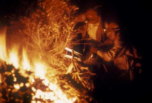
night firefighting
Barry Koncinsky running a chain saw on the El Cariso Hotshots, in 1971. Photo by Bill Gabbert.

International Firefighters’ Day was established in 1999 to honor the lives of five firefighters who died in a wildfire in Linton, Victoria, Australia, on December 2, 1998 – Garry Vredeveldt, Chris Evans, Stuart Davidson, Jason Thomas, and Matthew Armstrong.

May 4 has been selected as a day to recognize the service and sacrifice that all firefighters around the world make daily. Here at Wildfire Today we especially appreciate wildland firefighters, tactical athletes who take on vegetation fires from the air, from engines, and those on foot using hand tools while carrying 45 pounds of gear.

We also need to recognize the others who work at logistics, dispatch, warehouses, and tanker bases. Just as important are the families of these men and women who temporarily lose their spouse, son, or daughter for weeks at a time during the fire season. Too often there is an empty seat at anniversaries, birthdays, soccer games, and summer vacations.

Thank a firefighter today.

Fire within CZU Lightning Complex burns 7 acres

In Big Basin State Park south of San Francisco — may be a holdover from the fire 9 months ago

Basin Fire at 12:25 PDT May 2, 2021
Basin Fire at 12:25 PDT May 2, 2021. From PG&E camera.

On Monday firefighters suppressed a fire that burned within the perimeter of the CZU Lightning Complex of fires. The blaze was in Big Basin Redwoods State Park south of San Francisco and could be a holdover from the 86,502-acre blaze from August, 2020.

When firefighters hiked into the fire it was less than two acres, but with the assistance of aircraft they stopped the spread after it burned about seven acres.

In January several other holdover fires were found in the footprint of the same fire.

Map of Fires in San Mateo and Santa Cruz Counties
Map of Fires in San Mateo and Santa Cruz Counties, Jan. 19, 2021.

There is a chance that considering the numerous very large fires that spread through California and Oregon last year, and with lower than normal precipitation during the winter, other similar holdover fires will be discovered. In many cases since they are within the burn perimeter, they may not be a serious problem. But if they are in a large unburned island, burning embers lofted into the air could ignite spot fires some distance away, perhaps outside the perimeter where there is an abundance of available fuel.

The Park has been closed for the last 9 months after the fire destroyed most of the infrastructure. On August 28, 2020 the Park released a list of the structures that were known to have been destroyed at that time:

  • Historic Park Headquarters
  • Historic (Main) lodge
  • Ranger Station
  • Nature Museum
  • Store
  • Maintenance Shop
  • Multiple park residences, including some Saddle Mountain Property structures
  • Multiple campground bathrooms
  • Gatehouse
  • Bridge between North Escape Road and Gazos Creek Road
  • Many structures at Little Basin
  • Jay Camp Seasonal Housing

Southern Fire burns structures southeast of Julian, CA

CAL FIRE reports it has blackened 5,184 acres

Updated at 4:54 p.m. PDT May 2, 2021

Southern Fire map
Southern Fire map at approximately 2 p.m. PDT May 2, 2021. Data from NIFC/FIRIS.

CAL FIRE has updated size of the Southern Fire near Shelter Valley 8 miles southeast of Julian, California, reporting at 2:35 p.m. Sunday that it had burned 5,184 acres.

As seen in the photo below taken at 4:43 p.m. Sunday four miles away from Monument Peak, the fire from that distance looks pretty quiet.

Southern Fire
The Southern Fire (at the arrow) as seen from Monument Peak, looking north at 4:43 p.m. PDT May, 2, 2021. ALERTWildfire.

Resources assigned to the fire include 20 engines, 8 water tenders, 10 hand crews, and four dozers, for a total of about 200 personnel.


10:00 a.m. PDT May 2, 2021

Southern Fire map 3:18 a.m. PDT May 2, 2021
Southern Fire map, APPROXIMATE LOCATION, from data as late as 3:18 a.m. PDT May 2, 2021. It is based on satellite and FIRIS data. This is APPROXIMATE fire location information, not to be used for planning or decision making.

The Southern Fire in East San Diego County 8 miles southeast of Julian, California has prompted the evacuation of about 500 people and destroyed three structures in Shelter Valley. The residents were relocated from the Butterfield Ranch Campground to Agua Caliente.

At 9:43 a.m. Sunday there was a relatively small amount of smoke visible from Monument Peak which is near Mount Laguna.

Southern Fire May 2, 2021
The Southern Fire as seen from Monument Peak, looking north at 9:43 a.m. PDT May 2, 2021. ALERTWildfire.

At about 9 a.m. PDT Sunday morning CAL FIRE reported that the Southern Fire had burned 2,900 acres. (See map above.) Firefighters battled strong 40 to 60 mph winds during the night, and according to the forecast the weather is going to continue to be a challenge.

A wind advisory is in effect for San Diego County for strong winds through Sunday night. In the fire area the wind is predicted to increase from 23 mph gusting to 36 at 11 a.m. out of the west and west-southwest, to 32 mph gusting to 47 by 5 p.m. It will then gradually decrease by 6 a.m. Monday to 12 mph gusting to 20 out of the northwest. The high temperature on Sunday will be 77 degrees with a minimum relative humidity of 27 percent. The humidity will increase Sunday night to 40 to 55 percent.

Five miles west of the fire and 2,000 higher in elevation at Harrison Park, Cuyamaca State Park, and Julian, low clouds have increased the humidity to 100 percent.

Since the fire was reported at about 4 p.m. on Saturday, it has been spreading generally to the east and southeast.

Wildfire forces evacuations southeast of Julian, CA

The “Southern Fire” is near Highway S-2

Updated at 10:09 p.m. PDT May 1, 2021

Southern Fire map
Southern Fire map, approximately 8 p.m. MDT May 1, 2021.

The FIRIS Intel 12 mapping aircraft overflew the Southern Fire at approximately 8:00 p.m. May 1 and determined that it had burned at least 1,500 acres. At that time the fire was still actively spreading.


Updated at 7:09 p.m. PDT May 1, 2021

CAL FIRE reported at 6:38 p.m. Saturday that the Southern Fire southeast of Julian, CA had grown to approximately 1,200 acres and 3 structures had been destroyed. About 500 residents have evacuated from the Butterfield Ranch Campground. After evacuation, the assembly point is Agua Caliente.

(To see all articles on Wildfire Today about the Southern Fire, including the most recent, click HERE.)

The fire is spreading to the east pushed by strong winds measured at 33 mph with gusts to 40 at the Harrison Park weather station at 6:50 p.m.

The weather forecast for the fire area produced by the NWS at 5:31 p.m. Saturday predicts the gusty winds will continue through Sunday. For Saturday night, the wind will be out of the northwest at 15 to 20 with gusts to 25, with 45 percent humidity. On Sunday the wind will be a little stronger in the afternoon with 20 percent humidity and a temperature of 82.


Originally published at 5:35 p.m. PDT May 1, 2021

Southern Fire map
Map showing the approximate location of the Southern Fire in East San San Diego County, May 1, 2021.

Saturday afternoon the Southern Fire that was reported at about 4 p.m. in East San Diego County in Southern California spread quickly pushed by strong winds. The fire is in the community of Shelter Valley near Highway S-2 south of the Highway 78 Banner Grade about 11 miles southeast of Julian.

At 5:13 p.m. CAL FIRE said evacuations were in progress for the Butterfield Ranch campground.

At about 4:50 p.m. PDT on Saturday an Air Attack aircraft reported structures were threatened and the fire had burned about 40 acres with a critical rate of spread.

Southern Fire at 5:07 p.m. PDT May 1, 2021
Southern Fire, looking north from Monument Peak at 5:07 p.m. PDT May 1, 2021. ALERTwildfire image.

At 4:45 p.m. PDT a weather station not far from the blaze recorded 20 mph winds gusting out of the west-northwest at 35 mph. The wind is keeping the smoke close to the ground, rather than rising and creating a large vertical column. The temperature was 82 degrees with 8 percent relative humidity. Under those conditions water or retardant-dropping aircraft would would have reduced effectiveness.

Wildfire potential in the Southwest expected to remain above normal through June

It is also predicted to be above normal in much of the Great Basin through August

May wildfire outlook

The forecasts for wildland fire potential issued May 1 by the National Interagency Fire Center for May through August predict wildfire potential will be higher than normal in the Southwest until the monsoons arrive in July. Fire potential is also expected to be high in much of the Great Basin for the entire period and will be increasing in the mountains of California from June through August.

The Great Plains and Northern Rockies are slated for normal conditions but Central Oregon and Southeast Washington will be above normal beginning in June.

The data from NIFC shown here represents the cumulative forecasts of the ten Geographic Area Predictive Services Units and the National Predictive Services Unit.

Below:

  • An excerpt from the NIFC narrative report for the next several months;
  • More of NIFC’s monthly graphical outlooks;
  • NOAA’s three-month temperature and precipitation forecasts;
  • Drought Monitor;
  • Keetch-Byram Drought Index.

    “Climate outlooks indicate warmer and drier than normal conditions are likely for much of the Plains and West into summer continuing and exacerbating drought there. A Fuels and Fire Behavior Advisory is in effect for North Dakota, eastern Montana, and northwest South Dakota due to drought and continuous fine fuels. Near normal timing and precipitation are expected with the Southwest Monsoon in July, which will help alleviate drought and significant fire activity.

“Near normal significant fire potential is forecast across the northern Plains into the Great Lakes for May, but dry periods followed by strong winds could increase fire activity above normal. Outside of increased fire potential in western Oklahoma and west Texas, Southern area is likely to have near normal fire potential with elevated activity possible in and around northern Florida in May.

“The Southwest is forecast to have above normal significant fire potential through June before the Southwest Monsoon arrives. Above normal significant fire potential will expand northward into the Great Basin and Rocky Mountain Geographic Areas through August with areas closer to the monsoon likely returning to near normal significant fire potential in July and August. Central Oregon into southeast Washington are likely to have above normal significant fire potential beginning in June with portions of the Coast Ranges, Sierra, and Cascades in California increasing to above normal in June and July and continuing through August. Leeside locations of Hawaii are likely to have above normal significant fire potential in July and August due to heavier fuel loading and forecast warm and dry conditions, while Alaska should have near normal significant fire potential through summer.”


June wildfire outlook July wildfire outlook August wildfire outlook

Temperature outlook May-July, 2021
Precipitation outlook May-July, 2021

Drought Monitor April 27, 2021 Keetch-Byram Drought Index