Senators ask GAO to assess hiring and retention of federal wildland firefighters

Nine Senators signed letter asking how to strengthen the federal firefighting workforce

Briefing on Springs Fire
Firefighters gather for a briefing on the Springs Fire on the Boise National Forest near Banks, Idaho, August 12, 2020. Kari Greer photo for U.S. Forest Service.

Nine U.S. Senators signed a letter requesting that the Government Accountability Office (GAO) conduct an assessment of hiring and retention of federal wildland firefighters at the five federal agencies responsible for wildland fire. Those agencies are:

  • Forest Service
  • Bureau of Indian Affairs
  • Bureau of Land Management
  • Fish and Wildlife Service
  • National Park Service

The Senators, almost 10 percent of all Senators, asked that the GAO make recommendations for how these agencies can improve wildfire prevention and suppression efforts by strengthening the federal firefighting workforce.

Excerpts from the letter:

Wildfires in the West are now a near-constant threat and we can no longer afford to rely on just a seasonal firefighting workforce. Transitioning to a larger, full-time workforce would add immediate capacity to fight wildfires nationwide, allow for greater flexibility in shifting personnel between regions depending on wildfire activity, provide more stable work opportunities and employee benefits, increase employee retention, and reduce agency costs and burdens associated with the seasonal hiring process.

[…]

Assess whether OPM should create a new, separate job series and pay scale for federal wildland firefighters to ensure their pay is commensurate with state firefighting agencies and reflects their training requirements and the hazardous conditions they must endure.

The Grassroots Wildland Firefighters had some input into this effort. This is a rapidly growing organization that is becoming a factor in implementing changes that could benefit Forestry and Range Technicians whose primary job is fighting wildland fires.

This is the organization’s mission:

The Grassroots Wildland Firefighter Committee is dedicated to promoting and advocating for Federal Wildland Fire personnel titled Forestry Technicians and Range Technicians. Our mission is to advocate for proper classification, pay, benefits and comprehensive well being. Our mission is to educate the public, generate support and provide solutions to our federal representatives through policy reform.

The three-page letter written by the Senators is below. To scroll to the additional pages, click on or hover your mouse over the document then click on the down arrow at bottom-left.

[pdf-embedder url=”https://wildfiretoday.com/wp-content/uploads/2021/04/Letter-to-GAO-Federal-Firefighting-Workforce.pdf” title=”Letter to GAO – Federal Firefighting Workforce”]

The Pack Test involves risk

Between 2011 and 2019 five people were killed while taking the test

Work Capacity Test or Pack Test
Taking the Work Capacity Test

The Wildland Fire Lessons Learned Center put together the following information about serious incidents and fatalities that occurred while taking the Work Capacity Test, or Pack Test. Many agencies involved in wildland fire in the United States are required to administer the test to employees who respond to wildfires. There are three levels depending on the amount of physical activity required for the job. On-the-line firefighters are required to take the Arduous Level, known as the Pack Test, carrying 45 pounds for three miles in less than 45 minutes.

[pdf-embedder url=”https://wildfiretoday.com/wp-content/uploads/2021/04/Work_Capacity_Test_Infographic_2021.pdf”]


Additional information is available in .pdf downloads about the following Pack Test incidents:

In 2019 we conducted a poll about the Pack Test.

To see all articles on Wildfire Today tagged “Pack Test”, click here.

Former Forest Service Fire Staff Officer to testify before Congress

Investing to increase the capacity of the federal workforce to plan for and respond to wildfire

Committee hearing April 29 fire wildfire

Riva Duncan, now retired from the Fire Staff Officer position on the Umpqua National Forest in Oregon, is scheduled to testify before Congress Thursday April 29.

The House Subcommittee on National Parks, Forests, and Public Lands, led by Chair Joe Neguse (D-Colo.), will host an oversight hearing titled Wildfire in a Warming World: Opportunities to Improve Community Collaboration, Climate Resilience, and Workforce Capacity.

The Subcommittee describes one of the topics of the hearing:

Congress and the Biden administration have an opportunity to better incorporate climate change into federal land and wildfire policies by protecting naturally resilient landscapes, prioritizing funding for community collaboration and protection, and investing to increase the capacity of the federal workforce to plan for and respond to wildfire.

Ms. Duncan is now the Executive Secretary of Grassroots Wildland Firefighters.

Other expected witnesses:

  • Courtney Schultz, Associate Professor of Forest & Natural Resource Policy, Director of the Public Lands Policy Group at CSU, Department of Forest and Rangeland Stewardship, Colorado State University.
  • Beverly Law, Professor Emeritus, Global Change Biology & Terrestrial Systems Science, Oregon State University
  • Minority witness to be announced

When:

1 p.m. EDT, Thursday April 29

Written testimony:

Written testimony from the witnesses will be posted at the Committee’s website shortly before the hearing begins. Ms. Duncan’s is 13 pages long.

How to watch live:

You can watch it right here. When the hearing begins, click on the Play button on the YouTube screen below.

After the hearing is over, it should be possible to replay it above, or on YouTube.

Three Rivers Fire in New Mexico grows to 6,000 acres

Eight miles northwest of Ruidoso

Updated at 9:45 a.m. MDT April 27, 2021

  1. Three Rivers Fire, map wyyyy ffednffn and Three Rivers Fire, map 4:30 p.m. MDT April 26, 2021.

The latest information available about the Three Rivers Fire in New Mexico is that as of Monday afternoon it had burned 6,100 acres, and was about 8 miles northwest of Ruidoso and six miles west of Sierra Vista.

The primary direction of spread is generally toward the northeast, but the right flank is also moving to the east.

(To see all articles on Wildfire Today about the Three Rivers Fire, including the most current, click here.)

As this is written at 8:12 a.m. on Tuesday the live camera at Ruidoso shows wet streets. The weather forecast for the fire area on Tuesday calls for a minor chance of light rain showers. Minimum relative humidities will remain between 25 and 30 percent with breezy 15 to 25 mph winds out of the southwest with gusts up to 35 mph. Temps will be below to well below average through Friday, then back above average this weekend.

Evacuations are still in effect for the Three Rivers Fire :

• Nogal Canyon Area
• Bonito Canyon Area
• Tanbark
• Church
• Ranchman’s Camp
• Loma Grande
• Cora Dutton
• Magado
• Ski Apache

Evacuation Centers
• Nazarean Church Camp, 200 Bonito Park Rd. Alto, NM 88316
• Capitan Senior Center at 412 Tiger Drive Capitan, NM 88316
• Ruidoso Downs Senior Center at 393 Highway 70 West Rd. Ruidoso Downs, NM 88346.

Three Rivers Fire, April 26, 2021. USFS photo. Three Rivers Fire, April 26, 2021. USFS photo.

Three Rivers Fire forces evacuations in Southern New Mexico

8 miles northwest of Ruidoso

Updated at 7:16 p.m. MDT April 26, 2021

Three Rivers Fire map
The Three Rivers Fire has spread into the Little Bear Fire of 2012.

The 6,100-acre Three Rivers Fire 10 miles northwest of Ruidoso, New Mexico has spread into the footprint of the Little Bear Fire of 2012. Residents of the area will remember that fire because it stirred up a great deal of controversy.

(To see all articles on Wildfire Today about the Three Rivers Fire, including the most current, click here.)

Much of the criticism of the Little Bear fire was focused on what appeared from a distance to be less than aggressive suppression tactics, even though it was a suppression fire. Two firefighters worked the fire on the first day, June 4, 2012, and from day two through day five, while the fire was only four acres, a hotshot crew was assigned, but they had very, very little aerial firefighting support; limited use of one helicopter and no air tankers. On the fifth day the wind increased, a tree in the interior of the fire torched, and spot fires took off. The fire grew from 4 acres to 44,000 acres and destroyed 254 structures.

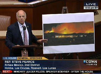
Rep Steve Pearce House of Representatives speech, western wildfiresIn June, 2012, Representative Steve Pearce was extremely critical of the way the U.S. Forest Service was managing the fire and the 297,000-acre Whitewater Baldy Complex in New Mexico, mentioning the name of Tom Tidwell, Chief of the Forest Service, many times during a 22-minute speech on the floor of the House of Representatives.

Rep. Pearce had five reports written about the two fires


Updated at 6:49 p.m. MDT April 26, 2021

Three Rivers Fire, satellite photo map
Three Rivers Fire, satellite photo 5:46 p.m. MDT April 26, 2021.

At about 5 p.m. Monday the Lincoln National Forest lengthened the list of locations under evacuation notices for the Three Rivers Fire northwest of Ruidoso, New Mexico:

• Nogal Canyon Area
• Bonito Canyon Area
• Tanbark
• Church
• Ranchman’s Camp
• Loma Grande
• Cora Dutton
• Magado
• Ski Apache

Evacuation Centers
• Nazarean Church Camp, 200 Bonito Park Rd. Alto, NM 88316
• Capitan Senior Center at 412 Tiger Drive Capitan, NM 88316
• Ruidoso Downs Senior Center at 393 Highway 70 West Rd. Ruidoso Downs, NM 88346.

The latest size estimate is 6,100 acres. The fire is spreading very rapidly.


Within hours of the Three Rivers Fire detection on the Lincoln National Forest in New Mexico, evacuations were ordered. The fire is about 10 miles northwest of Ruidoso. It is one-half mile above Three Rivers Campground near the White Mountains on the Smokey Bear Ranger District between Tularosa and Carrizozo.

Evacuation notices are in effect according to the U.S. Forest Service for Nogal Canyon, Bonito Canyon, and the Ski Apache area.

At about 11 a.m. officials estimated the size at 30 acres, but judging from the live video from Ruidoso at 2:40 p.m. it appears to be growing rapidly. The latest report puts it at approximately 4,000 acres.

The fire is being pushed by a strong wind gusting out of the southwest at up to 38 mph. That wind speed was recorded at a weather station in Ruidoso which at 2:35 p.m. April 26 showed 66 degrees and 7 percent relative humidity. The forecast is for wind gusts up to 55 mph in the afternoon. These conditions will make it very difficult to impossible for firefighters to get out in front and stop the forward progress of the fire —  or for retardant-dropping aircraft to be effective.

A Type 1 Incident Management Team has been ordered. Other resources ordered or onsite as of 2:10 p.m. MDT included 2 single-engine airtankers, 1 hotshot crew, 2 other hand crews, and 5 engines.

Flag Fire prompts evacuations southeast of Kingman, AZ

Hualapia Mountain Park and Pine Lake are threatened

Updated at 2:12 p.m. MDT April 26, 2021

Flag Fire. April 26, 2021
Flag Fire. April 26, 2021. BLM photo.

The Bureau of Land Management reported at 1:20 p.m. MDT Monday that the Flag Fire 12 miles southeast of Kingman, Arizona was mapped Monday morning at 1,400 acres. There have been no injuries or structures destroyed. Overnight firefighters extinguished spot fires near homes and conducted tactical burning operations.

Flag Fire map
Flag Fire map. Updated at 12:45 p.m. MDT April 26, 2021. NIFC.

The Arizona Central West Zone Type 3 Incident Management Team  assumed command at 9 a.m. Monday. A higher qualified IMT, a Type 1, has been assigned and is expected to transition with the Type 3 team tomorrow, April 27.

Flag Fire. April 26, 2021
Flag Fire. April 26, 2021. BLM photo.

The Mohave County Sheriff’s office still has evacuations in effect for Hualapai Mountain Park, the Lodge, and the Pine Lake Community, affecting about 200 households.


Originally published at 9:31 p.m. MDT April 25, 2021

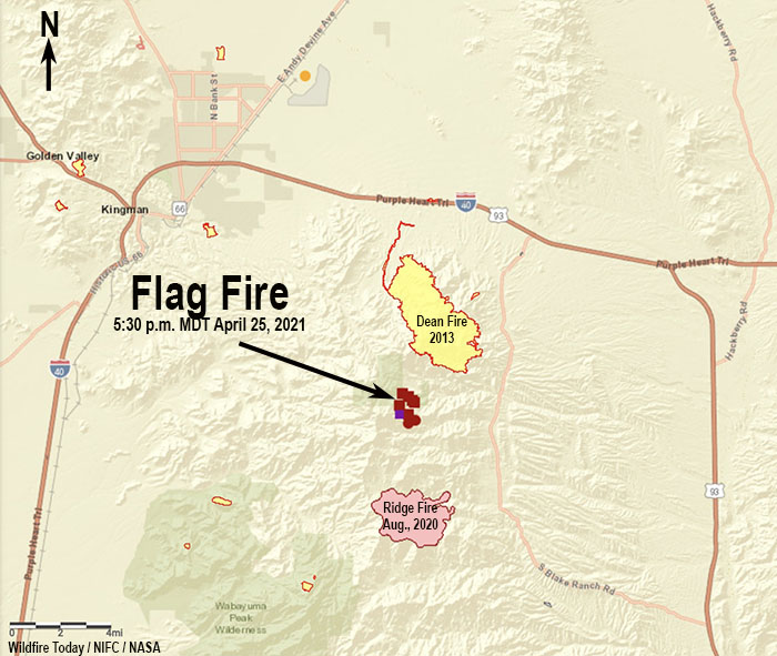
Flag Fire map
Flag Fire map. The icons represent heat detected by satellites as late as 5:30 p.m. MDT April 25, 2021.

The Flag Fire reported at 2 p.m. Sunday is prompting evacuations about 12 miles southeast of Kingman, Arizona. The Mohave County Sheriff’s Office has ordered the evacuation of Hualapai Mountain Park, Lodge, and the Pine Lake Community. The Sheriff’s Facebook page has details. Sunday evening the Bureau of Land Management reported that the fire had burned approximately 600 acres.

A strong wind Sunday afternoon out of the south and southwest gusting at 20 to 30 mph pushed the blaze to the north. The wind will continue through Sunday night, according to a spot forecast, but the relative humidity will increase to 60 percent. There is a chance of showers Monday in the fire area with the RH expected to be around 50 percent, the temperature in the low 40s, and 10 to 20 mph winds out of the southwest.

The map of the area above shows two previous fires within three or four miles of the Flag Fire. On Sunday it was moving north toward the footprint of the Dean Fire that burned 5,417 acres in 2013 on the same day the Yarnell Hill Fire burned over and killed 19 firefighters. The two fires were competing for air tankers.

To the south is the Ridge Fire that grew to more than 3,000 acres in 2020.

The Flag Fire started between the Flag Mine and Wild Cow Campground in the Hualapai Mountains. It is being managed by the Bureau of Land Management.

An Arizona Type 3 Incident Management Team is on order. Other resources on scene or requested Sunday included 1 lead plane, 3 large air tankers, 3 single engine air tankers, 3 helicopters, and 5 hotshot crews.

Flag Fire, April 25, 2021
Flag Fire, April 25, 2021. Photo by Whitney Clark.