Prescribed fire escapes on Eldorado National Forest

The fire has burned over 2,000 acres 15 miles southwest of Lake Tahoe in Northern California

Caples prescribed fire October 7, 2019
Caples “prescribed fire”. Photo by Forest Supervisor Laurence Crabtree, published October 7, 2019.

I was first aware of the Caples  prescribed fire on the Eldorado National Forest when three tweets were published by the forest’s Twitter account on the afternoon of Monday October 7 saying, “Ignitions continue on Caples Prescribed Fire. More smoke is expected”. Photos taken from an aircraft by Forest Supervisor Laurence Crabtree also were Tweeted.

At that time there had  been news and discussions for several days in the wildland fire community about very strong winds and Red Flag Warnings that were due to hit California Wednesday October 9. Smoke from the prescribed fire was easily detected by a satellite October 7. It was a large amount of smoke to be generated by what was supposed to have been some burning debris piles.

The project began October 1 and involved disposing of debris piles by burning. Additional ignitions occurred on October 5 and 7.

The information below came from the @EldoradoNF Twitter account.

Tuesday, October 8:  A tweet from the National Forest said, “The goal of today’s burn operation is continue active ignitions to reach the end of the ridge and tie into a dozer line that extends to the 10N30 road before the wind event that is predicted for this evening. No additional ignitions are planned this week.” And later that day, “Ignitions on the Caples Prescribed Fire have been completed and crews will patrol and monitor the area over the next few days during the wind. No additional ignitions are planned this week. ”

Wednesday October 9: “Today’s goal is to finish active ignitions to tie into the 10N30 road before the wind event now predicted for Wednesday night. Ignitions were intended to be done yesterday but due to unfavorable wind conditions during the day shift the operation is continuing today.”  And later that day, “Personnel on the Caples Prescribed Burn continue ignitions down the western perimeter of the fire towards forest road 10N30. A total of 1,080 acres have been treated, exceeding today’s target.” And later, “Ignitions are complete on the western end of the Caples Burn. Crews will patrol and monitor the area over the next few days during the wind event predicted to start this evening. Smoke will continue to be visible as the fire consumes unburned fuels within the fire perimeter.” And later, “The scheduled PG&E Power Outage has resulted in the closure of Eldorado National Forest offices except Camino ECC. Fire and essential personnel continue to work, however, forest offices are not open and phones are not operational until power is restored.”

Thursday, October 10: No additional information except for a Community Meeting scheduled in Pollock Pines that evening. One of the six items on the agenda was, “Brief updates on Caples Prescribed Fire and PG&E Power Outage”.

Friday October 11: “The Caples prescribed burn declared a wildland fire on today at 1:30 pm. Fire managers made the decision due to unfavorable weather conditions and the inability to meet previously established objectives. Inciweb is down. We will update when it comes back up.”


Today, October 11, personnel from the Eldorado National Forest report that the fire has burned 2,143 acres. It is 3 miles west of Kirkwood and 15 miles southwest of the south shore of Lake Tahoe. Approximately 152 personnel and a Type 3 Incident Management Team has been assigned.

Here is a report from the Northern California Geographic Coordination Center, Friday morning October 11:

Extreme fire behavior with wind driven runs, torching and spotting has been observed. A Red Flag Warning is in effect until 1000 this morning for the fire area. There is a threat to structures on remote ranches in the area. Private timberlands, major municipal watershed, historical sites and critical wildlife habitat are also threatened. Smoke impacts to the Sacramento Valley and Lake Tahoe areas are possible. Road, trail and area closures are in effect in the fire area.
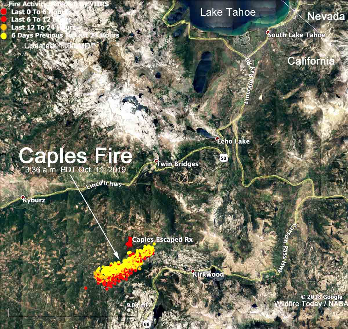
Caples Fire Map
Map showing heat on the Caples Fire detected by a satellite at 3:36 a.m. PDT October 11, 2019.

Caples Fire escaped prescribed fire information

Thanks and a tip of the hat go out to Fred. Typos or errors, report them HERE.

Saddle Ridge Fire burns over 7,000 acres and dozens of homes in Los Angeles

The fire is near Sylmar and Granada Hills

UPDATED at 6:16 PDT October 12, 2019

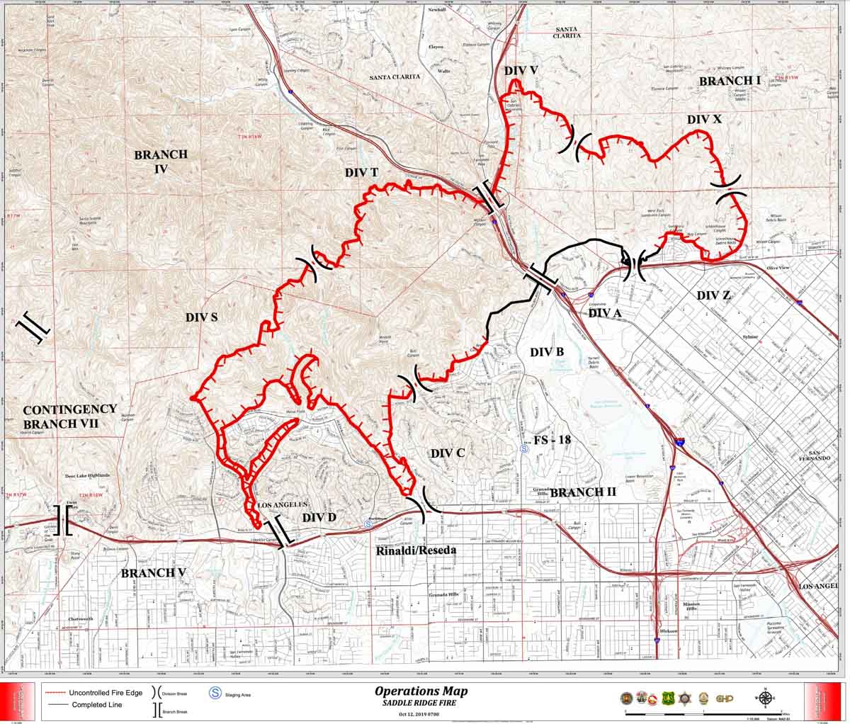
Map of the Saddle Ridge Fire, October 12, 2019
Map of the Saddle Ridge Fire, October 12, 2019. Los Angeles Fire Department.

Map of the Saddle Ridge Fire, October 12, 2019.


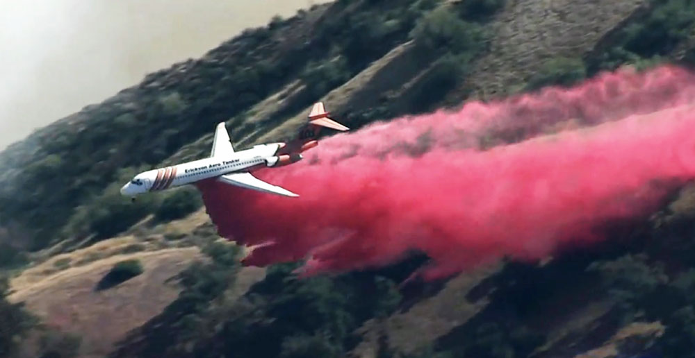
MD87 drops on Saddle Ridge Fire
Air tanker 101, an MD87, drops on the Saddle Ridge Fire on the north side of Los Angeles at 2:24 p.m. PDT October 11, 2019. Screenshot from KTLA video.

UPDATED at 7:12 p.m. PDT October 11, 2019

The Los Angeles Fire Department reported Friday afternoon that the Saddle Ridge Fire had burned 7,542 acres and was being fought by 1,000 firefighters. Numerous helicopters and air tankers are assisting firefighters on the ground, including the two Super Scoopers from Quebec under contract with the Los Angeles County Fire Department. The fire started at about 9 p.m. on Thursday in Sylmar and spread across Interstate 5 into the Granada Hills area north of the 118 freeway.

At 5 p.m.  Friday the Los Angeles Fire Department began allowing  Los Angeles city residents who are under mandatory evacuation and whose homes are north of the 118 freeway to be escorted by LAPD personnel to their homes for a 5 minute period to obtain important documents, medication, small pets, etc. The two locations where residents can go to obtain escorts are the Porter Ranch Town center at Porter Ranch & Rinaldi and at the Target located at the northwest corner of Balboa & San Fernando Mission.

Evacuation orders are still in effect in several areas.

Super Scooper Castaic Lake water
A Super Scooper from Quebec on contract with Los Angeles County FD scoops 1,600 gallons of water at Castaic Lake Friday. LA County Parks and Recreation photo.

There has been no update on the number of structures destroyed since the Fire Department said Friday morning that 25 had burned. Assessment teams are working to gather more information.

One firefighter has sustained a minor eye injury and a civilian suffered a cardiac arrest and died at the hospital.

The wind pushing the fire slowed Friday afternoon, but at 6:40 p.m. was still strong, with sustained speeds of 16 to 20 mph gusting at 30 to 40. The relative humidity barely registered, hovering around five percent in the afternoon. The forecast indicates there will be no humidity recovery Friday night, with it maxing out at 9 percent by 7 a.m. Saturday, after which it will sink to five percent Saturday afternoon. The wind will remain out of the northeast Friday night and Saturday, 13 to 17 gusting at 20 to 26 during the night and 7 to 13 mph gusting to 17 Saturday morning. Saturday afternoon, the wind then out of the east, will relax to 7 mph. All this indicates that conditions on Saturday for battling the fire will be more favorable for firefighters.


UPDATED at 12:12 p.m. PDT Oct. 11, 2019

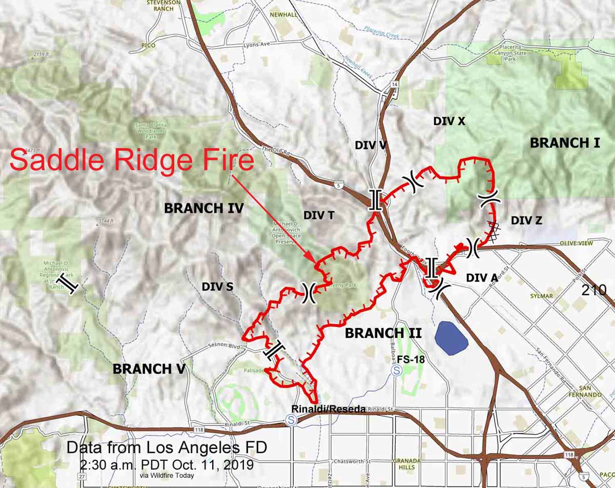
Air tankers and helicopters began hitting the Saddle Ridge Fire early in the morning on Friday, battling the wind in their attempts to drop fire retardant and water in strategic locations to slow the fire and assist firefighters on the ground. At least five large air tankers, two water scooping air tankers, and numerous helicopters worked the fire in the morning. (see map below)

After six a.m. the wind slowed slightly, decreasing at Newhall Pass to 22 mph gusting at 38 to 50 mph out of the north.

Saddle Ridge Fire map
Map showing the perimeter of the Saddle Ridge Fire at 2:30 a.m. PDT Oct. 11, 2019. Derived from a Los Angeles Fire Department product.
Saddle Ridge Fire Los Angeles
Firefighters protect homes on the Saddle Ridge Fire on the north side of Los Angeles. Screenshot from KTLA video at 11:45 a.m. Oct. 1, 2019.

9:35 a.m. PDT October 11, 2019

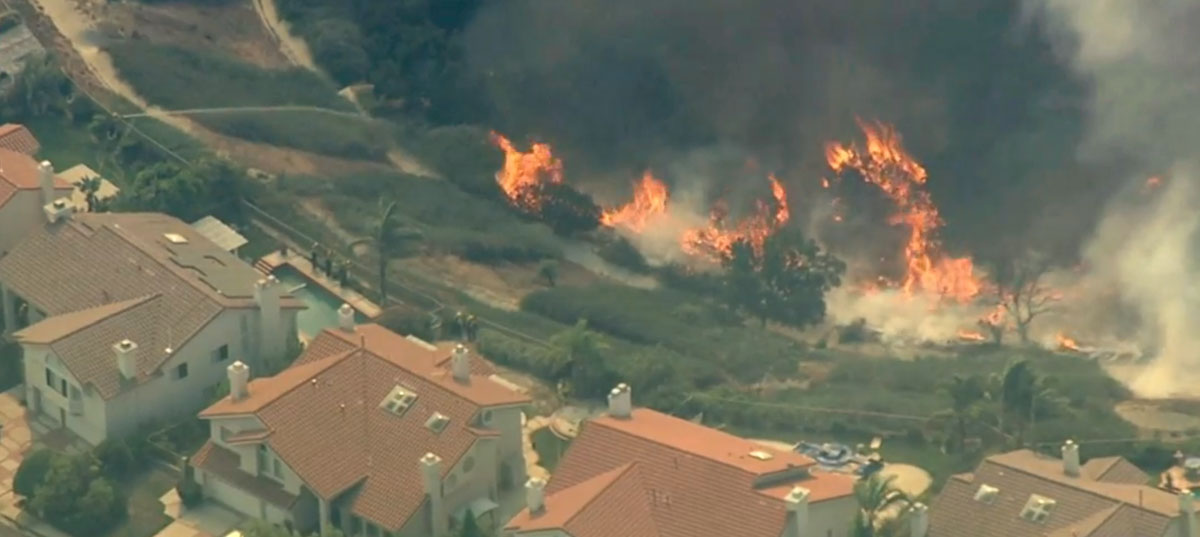
The Saddle Ridge Fire that was reported at 9 p.m. October 10 on the north side of Los Angeles has burned at least 4,700 acres and 25 homes. The fire started near Sylmar northeast of the interchange of the 210 and 5 freeways, jumped those highways and kept running to the southwest north of the 118 near the densely populated Granada Hills area. All three of those freeways have at times been closed due to the fire.

Continue reading “Saddle Ridge Fire burns over 7,000 acres and dozens of homes in Los Angeles”

Wildfire burning south of San Francisco on San Bruno Mtn.

Fire Brisbane, California
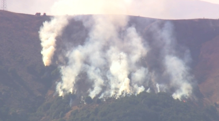
Fire on a steep slope above Brisbane, California south of San Francisco. Screenshot from ABC7 video.

A wildfire that started around 11 a.m. has burned approximately 10 acres on a steep north-facing  slope near Brisbane, California south of San Francisco. It is burning under high-voltage power lines, but there is no official  word on the cause.

The area  is  not in a PG&E preemptive power shutoff area.

Fire Brisbane, California
Fire on a steep slope above Brisbane, California south of San Francisco. Screenshot from ABC7 video.

ABC7 occasionally has live video.

Update on fire-related power shutoffs in California

UPDATED at 12:22 p.m. PDT October 10, 2019

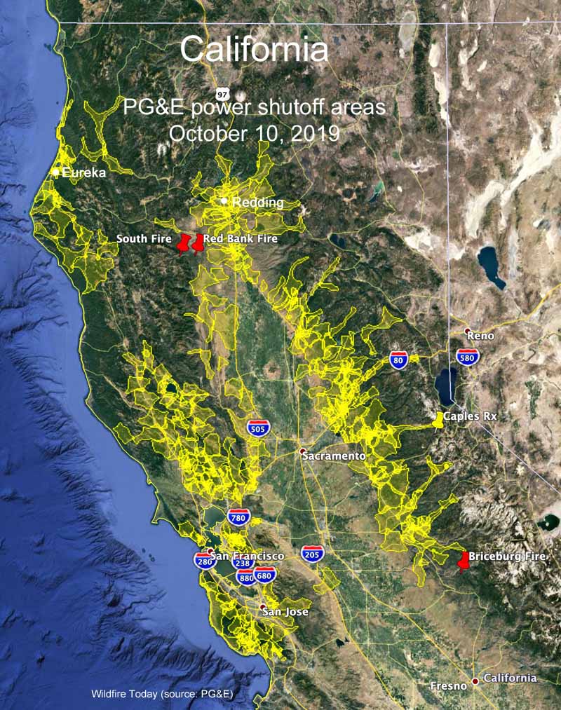
Recently updated information about Pacific Gas and Electric’s preemptive power shutoff for much of Northern California includes additional locations in the San Francisco Bay Area and the north coast near Eureka (see map above). This brings the total number of PG&E addresses affected to 800,000, which could translate to approximately two to four million residents.

PG&E power shutoffs California
PG&E power shutoffs in Northern California, October 10, 2019.

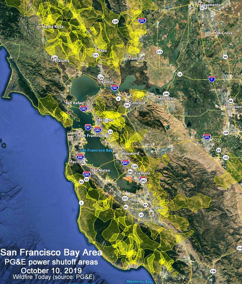
Below is a zoomed-in map showing the greater San Francisco Bay Area.

PG&E power shutoffs California
PG&E power shutoffs in the Bay Area of California, October 10, 2019.

According to PG&E they have been turning off the power during periods of high wildfire danger since 2013, never before at this magnitude.


San Diego Gas and Electric was one of the pioneers in turning off the power to their customers when the wind blows and has been doing it  for years.

“Moderate Santa Ana winds are expected to sweep through our region starting Thursday and peak on Friday morning, bringing elevated wildfire danger to the backcountry and the potential for Public Safety Power Shutoffs,” SDG&E said in a press release.

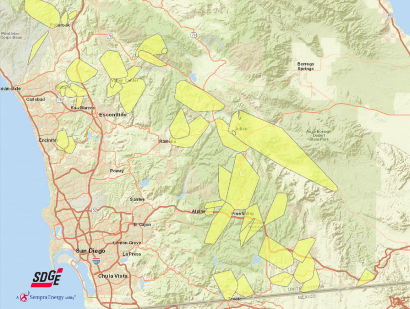
About  34,000 SDG&E customers have been notified their electricity may be turned off (see map below).

SDG&E turn off power wind
SDG&E says the areas in yellow could experience public safety power outages during the wind event that will hit San Diego County Thursday and Friday. (SDG&E map updated October 9, 2019.)

And in the Los Angeles area:

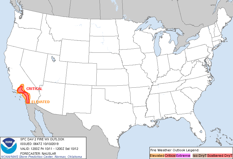
The fire danger in Northern California is expected to decrease on Friday but remain elevated in the south part  of the state.

Predicted fire weather for October 10, 2019
Predicted fire weather for Thursday October 10, 2019.
Predicted fire weather for October 11, 2019
Predicted fire weather for October 11, 2019.

What happens when a power company decides to turn off the electricity for millions of residents?

The preemptive power shutoff for 800,000 addresses by Pacific Gas and Electric in Northern California is directly affecting approximately two to four million residents. The power company took this action to prevent their feeble power line system from starting fires during this period of strong winds. Farther south in California, San Diego Gas and Electric has warned residents living at 30,000 addresses that their power could also be turned off this week.

The indirect effects of having no electricity expand to a much larger  population when you consider traffic lights not working, tunnels on highways being shut down, plus the closure of gas stations, schools, and businesses. At some point cellular telephone towers and infrastructure may exhaust their emergency power supply systems, not to mention the batteries in the public’s cell phones.

Firefighters’ communications could be hampered by the disabling of their radio repeaters on mountain tops. Notifying residents of approaching fires and conducting evacuations in order to save lives could be challenging.

All that is the assessment of someone hundreds of miles away. For the thoughts of a person much closer to what is actually happening on the ground, we turn to Rob Carlmark, a meteorologist for ABC10 in Sacramento, who is surrounded by areas affected by PG&E’s power shutoff. Here, with his permission, are samples of what he has been writing on his Twitter account, @rcarlmark:


10:25 a.m. October 9, 2019

So here is what’s happening on the ground in California for the fire weather story. It’s genuinely freaking everybody out. If we get ZERO fires out of this (small miracle) the power shut off will be remembered for a long time. #MorningBlend10

Rob Carlmark
Rob Carlmark photo.

Despite the pretty large media effort by PG&E to warn people of the power outages…many people we are talking to at closed gas stations had no idea. Turns out not everyone…especially in rural areas look at the internet all day. Some of these folks were BLINDSIDED. We have to take them at their word because they are far away from the windiest areas affecting lines or COULD affect lines. Many work far away, and fuel up often. If you are at a gas station…let’s face it you NEED gas and maybe can’t drive 15-20 miles away to get it…or wait in long lines to get gas. They also have an unexpected day off work…maybe cancelled school..kid/kids to pick up and figure out what to do for DAYS with no power. Of course the alternative is having power on…and a well known source for fires active.

This is a tough spot to be in for 100,000s of customers which likely includes million+total in actual population if you extrapolate for households etc.

They are not going to reimburse people for spoiled food since it was planned. If an outage was caused by an extreme event and weather they might…case by case basis.

Also remember a lot of these people just got hit with a non-renewal for home insurance and if they found someone…it costs drastically more. Also remember that many of these people are actively trying to move…sell their home…can’t find insurance for new buyer or are dropping their prices all the time. This is the APEX of stress in some of the most beautiful places you ever could live.

We need to add more places… the Bay area is about to find out today if one of the major tunnels…MAJOR…will have to shut down for power outages at noon. Traffic there is a true daily horror show…and if you find this out…at work you are going to freak.

We haven’t even talked about Southern California…they too will experience massive outage issues potentially…STRONGER winds and LOWER humidity.

WE HAVEN’T EVEN HAD A FIRE YET! If that happens…which the odds are fairly high…it immediately turns into a dangerous life-threatening event with little info, or ways to get info (no power…no gas).

Finally…peak wind will be middle of the night [Wednesday night/early Thursday]. It’s not just about power…there are DOZENS of ways fires start and any fluke accident could set up many communities for a dangerous moment.

If we can get through this…the power might not come back on for a few DAYS in some areas after the fact (no strong winds) while they inspect lines. fire or not this story will continue for many days more.


4:19 a.m. PDT October 10:

Update from what’s going on in California with this fire weather/power outage emergency. We are right in the thick of it and it’s not over yet.

We had a VERY close call in a town called Moraga near the Bay Area overnight. Fire broke out near a nice suburb surrounded by open land…a true urban/wildland interface situation. It was dicey, scary and in the middle of the night…gusts were 35mph+ nearby and evacuations were door to door with no cell service and power shut off.  By the hard work of firefighters and perhaps the advantage of having roads and access the fire is mostly contained and a nightmare scenario has been avoided…for now.

From what we can tell this is an area with a planned power outage and it’s a reminder that a fire can start form dozens of different ways…not just power arcs. We don’t know cause, but since the power was shut off there it’s worth exploring other causes

Supplies are running really low in power outage areas…water, flashlights, generators etc. have been in short supply like a true disaster emergency situation.

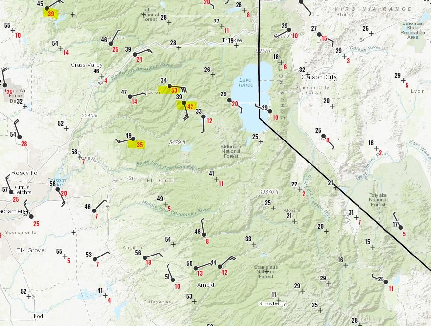
Easily the biggest complaint is “It’s not windy at my house…the power should be back on” Gusts near the dams/hydropower/transmission lines though are VERY strong up to 52 mph so upstream impacts are creating downstream confusion

Observed wind speeds in California
Observed wind speeds in California early Thursday morning. Rob Carlmark.

In short…it’s ongoing…people are on edge…every stoplight is a four way stop with traffic issues…people have NO idea when power is coming back…it’s a big deal that is getting bigger today.

I do see the weather changing tonight for many…less wind but still dry so there is an end to this in the weather world…but the power thing…it’s going to be some time.

Power company may turn off electricity to 30,000 addresses in Southern California during wind event

SDG&E may suspend electrical service to some customers this week

SDG&E turn off power wind
SDG&E says the areas in yellow could experience public safety power outages during the wind event that will hit San Diego County on Thursday and Friday.(SDG&E map)

Pacific Gas and Electric in Northern California is not the only power company with plans to turn off the electricity to their customers. San Diego Gas and Electric said they may suspend electrical service to about 30,000 addresses during the wind event on Thursday and Friday of this week. Thinking that their power line infrastructure may not be robust enough to withstand the wind, they want to reduce their liability by de-energizing the power lines, rather than fully hardening their electrical distribution system.

SDG&E was one of the pioneers in turning off the power to their customers when the wind blows and has been doing it  for years. They floated the idea in July, 2009 after their power lines started three massive fires in 2007 , the Witch Creek, Guejito, and Rice Canyon Fires, that burned more than 198,000 acres, destroyed more than 1,500 homes, injured 40 firefighters, and caused two deaths.  The company figured up to 150,000 people could be affected by a proactive power outage in 2009.

SDG&E has been trying for the last 7 years to get their customers to pay $379 million the company incurred in claims from the deadly 2007 fires. They took litigation all the way to the U.S. Supreme Court which ruled against them on October 7, 2019. After the verdict the company wrote in a news release,  “SDG&E has shown that the fires occurred due to circumstances beyond our control, but nevertheless the application to spread the costs through rates was denied.”

To be fair, SDG&E has taken steps to reduce the chances their power lines will start a fire during strong winds, such as replacing some wooden poles with metal poles. They have also put systems in place to deal with a fire before and after it starts, including making a large firefighting helicopter available beginning in 2010, hiring contract firefighters during extreme fire weather, and installing more than 100 weather stations on their power lines around Southern California.