Media day planned for firefighting aircraft at Colorado airport

The aircraft will make water drops but the public is not invited. Our opinion about this.

Air Tanker 23, a P3 Orion
File photo of Air Tanker 23, a P3 Orion. Airstrike Firefighters photo.

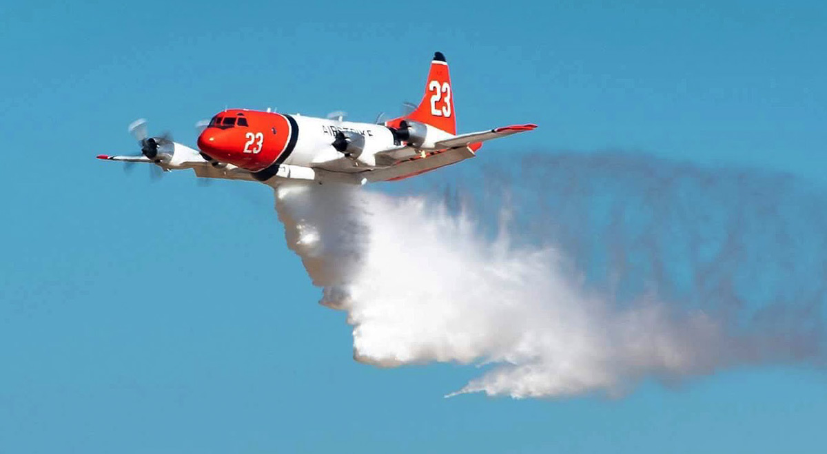
The Colorado Division of Fire Prevention and Control (DFPC) is planning a media day on June 28 at Northern Colorado Regional Airport in Loveland, Colorado (map). Two air tankers will be making demonstration drops — an Airstrike Firefighters P-3 Orion and a Single Engine Air Tanker (SEAT). They will be dropping BLAZETAMER380, a water enhancing gel that looks similar to water when released by an air tanker.

The DFPC  has a summer-long exclusive use contract for the SEAT and a Call When Needed (CWN) contract for Airstrike’s large four-engine P3 air tankers.

The airborne demonstrations are scheduled to begin at 10:30 a.m. MDT June 28, with static displays to follow.

The event is for the media, who will be escorted out to the ramps to get a close up look at the aircraft on static display. We were told by Shawn Battmer, the Airport Executive Assistant, that the public will not be allowed to approach the planes but may be able to see them through a fence near the Fort Collins-Loveland JetCenter. Mr. Battmer did not say anything about being able to see the water drops, but they will presumably be from 100 to 200 feet above the ground so sightseers may be able to find a spot where they get a good view of the demonstrations.

In August of last year the DFPC signed a CWN agreement with Airstrike Firefighters to provide large airtanker services for wildland fire suppression.  The agreement will allow the State of Colorado to access Airstrike’s P-3 airtankers to help combat wildfires in the State.

Airstrike Firefighters is making progress toward their goal of putting seven P3 Orion air tankers formerly owned by Aero Union back into service. The aircraft have not been used on a fire since the U.S. Forest Service canceled the Aero Union contract July 29, 2011 due to the company “failing to meet its contractual obligations”, according to the agency.

An Opinion:

The Colorado Division of Fire Prevention and Control and the Northern Colorado Regional Airport are missing what could have been a grand public relations opportunity by not allowing the public to get close to the static displays of the aircraft. It will be a lost opportunity to educate the public about aerial firefighting. They could at least set up a designated location outside the secure fence where the taxpayers who fund these aircraft could be ENCOURAGED to see how their money is spent as the air tankers make their drops. And further, it would have been possible to allow the public to go 150 feet or so out onto the ramp where they could walk around the three of four aircraft and talk to the pilots and crews. Air shows do this, and the Aerial Firefighting Conferences at Sacramento, Europe, and Australia do it as well, allowing hundreds of people out on the ramp. Portable barriers could be set up and volunteers or wildland firefighters could ensure that the visitors stay within the established viewing areas.

As you can see in the photo below, it is possible for the media to record interviews while others walk around the aircraft.

Attendees at the Aerial Firefighting Conference in Sacramento were allowed within a designated area of the ramp to examine the aircraft and talk to the flight crews while the media was conducting interviews. Photo By Bill Gabbert, March 12, 2018.
tour 747 Supertanker
At the Aerial Firefighting Conference in Sacramento on March 12, 2018 people lined up to tour the 747 air tanker. Photo by Bill Gabbert.

Vegetation fire spreads to vehicle dealership — 86 cars damaged or destroyed

Vegetation fire Bakersfield, CA burns 85 cars
Vegetation fire in Bakersfield, CA destroys or damages 86 cars. Screenshot from 23 ABC News.

A vegetation fire that started along the 99 freeway in Bakersfield, California Monday spread into a car lot and damaged or destroyed 86 cars.

A preliminary investigation is centered on a truck that was dragging a chain, creating sparks that ignited grass adjacent to the highway in spots scattered along a four-mile stretch.

The cars were in the CarMax lot at 6801 Colony Street. An information officer from the Bakersfield Fire Department said 26 cars were totaled and another 60 were damaged. The estimated monetary loss is $2.1 million.

CAL FIRE frequently reminds the public about the danger of dragging chains.

cal fire dragging chains start fire

Red Flag Warnings in Nevada this week

fire weather red flag warning
Red Flag Warning

A Red Flag Warning is in effect for areas of Western Nevada and Northwest California from 11 a.m. Wednesday until 1 a.m. Friday. The forecast calls for southwest winds of 15 to 25 mph with gusts at 40 to 45 with relative humidity levels at 8 to 10 percent. A Fire Weather Watch is in effect for Southern Nevada for the same time frame and similar weather conditions.

(Red Flag Warnings can be modified throughout the day as NWS offices around the country update and revise their weather forecasts.)


Four crews complete their fire assignments in Alberta

hotshot fire crew Alberta
Snake River IHC. Alberta, June, 2019.

@AlbertaWildfire sent out a tweet today with four pictures saying goodby to four crews that had been assisting in the Province:

Today we say goodbye to our US firefighters that assisted us at the McMillan Complex in the Slave Lake Forest area. Thank you to the Prineville, Logan, Union and Snake River Hotshot Crews; we appreciate the support. Safe travels and all the best back home! #ABfire #ABwildfire

Click on the photos to see larger versions.

hotshot fire crew Alberta
Logan IHC. Alberta, June, 2019.

(Let us know which crew is which and we’ll add the crew names in captions. UPDATE — got them all identified. Thanks!)

hotshot fire crew Alberta
Union IHC. Alberta, June, 2019.
Prineville IHC Alberta
Prineville IHC. Alberta, June, 2019.

In addition to a number of U.S. firefighters in Alberta, at least 11 crews from the lower 48 states are assigned in Alaska according to the Alaska Interagency Coordination Center: Los Padres, Lewis and Clark, Chief Mountain, Golden Eagles, Crane Valley, Idaho Panhandle, Lakeview, Redmond, Vale, Wolf Creek, and Winema.

Planning evacuations using dynamic fire vulnerability mapping

satellite photo Camp Fire Paradise California
Camp Fire as seen from NASA Operational Land Imager on Landsat 8 at 10:45 PST November 8, 2018. The photo, enhanced with infrared imagery, was taken about 4 hours and 15 minutes after the fire started.

In the last three years examples of wildfires in North America that have caused massive evacuations, fatalities, and structures destroyed include:

City officials in Paradise had an evacuation plan in place and had even conducted a drill, but the plan assumed a specific fire situation that would allow time for sections of the city to evacuate, one area at at time. The Camp Fire, driven by strong winds, hit the community so quickly that the entire city had to evacuate immediately, causing the limited and low volume evacuation routes to become clogged. A situation like that with very little advance notice would overwhelm many cities, especially if the availability and capacity of routes can’t come close to handling the traffic.

Managers can use computer models to predict the spread of fires, and there are also models that can estimate how much time it would take to evacuate people in vehicles or on foot. But these models have not been integrated to determine how changes in fire behavior would affect evacuation capability and plans.

A linked fire behavior and evacuation model could have variable inputs for weather, fuels, and topography as well as an assortment of evacuation alternatives that could inform planners about existing and proposed designs.

An integrated modeling system or simulator for dynamic fire vulnerability mapping does not exist, but researchers have laid out specifications and a framework for building one. Their recommendations are detailed in a paper published in Safety Science titled, “An open physics framework for modelling wildland-urban interface fire evacuations.”

dynamic fire vulnerability mapping
Illustration from the researchers. Click to enlarge.

Below is the abstract from their paper:

“Fire evacuations at wildland-urban interfaces (WUI) pose a serious challenge to the emergency services, and are a global issue affecting thousands of communities around the world. This paper presents a multi-physics framework for the simulation of evacuation in WUI wildfire incidents, including three main modelling layers: wildfire, pedestrians, and traffic. Currently, these layers have been mostly modelled in isolation and there is no comprehensive model which accounts for their integration. The key features needed for system integration are identified, namely: consistent level of refinement of each layer (i.e. spatial and temporal scales) and their application (e.g. evacuation planning or emergency response), and complete data exchange. Timelines of WUI fire events are analysed using an approach similar to building fire engineering (available vs. required safe egress times for WUI fires, i.e. WASET/WRSET). The proposed framework allows for a paradigm shift from current wildfire risk assessment and mapping tools towards dynamic fire vulnerability mapping. This is the assessment of spatial and temporal vulnerabilities based on the wildfire threat evolution along with variables related to the infrastructure, population and network characteristics. This framework allows for the integration of the three main modelling layers affecting WUI fire evacuation and aims at improving the safety of WUI communities by minimising the consequences of wildfire evacuations.”

Authors of the paper: Enrico Ronchi, Steven M.V. Gwynne, Guillermo Rein, Paolo Intini, and Rahul Wadhwani.

Wildfire smoke maps, June 23, 2019

Posted on Categories UncategorizedTags
wildfire smoke United States
Made by NOAA in the United States, this map depicts the extent of wildfire smoke at 9:52 a.m. MDT June 23.

These maps, produced by agencies in Canada and the United States, show the distribution of smoke from wildfires in both countries.

The map above, made by NOAA in the United States, depicts the extent of wildfire smoke at 9:52 a.m. MDT June 23.

The one below, from the Canadian government, is a forecast for the maximum amount of smoke expected to occur today, June 23. It only applies to the area within the box with the black border, and does not predict for the southern half of the United States.

wildfire smoke Canada United States
From the Canadian government, this is a forecast for the maximum amount of smoke expected to occur today, June 23. It only applies to the area within the box with the black border, and does not apply to the southern half of the United States.
wildfire smoke Canada United States
From the Canadian government, this is a forecast for the maximum amount of smoke expected to occur today, June 23. It only applies to the area within the box with the black border, and does not apply to the southern half of the United States.