Firefighters suppress a wildfire at Lake Como on Monte Berlinghera. Varese News
Two 22-year old students accused of accidentally starting a wildfire have each been fined €13,500,000 ($15,200,000). The fire burned about 1,000 hectares (2,470 acres) near Lake Como in Italy, ignited, investigators determined, by embers from the barbecue at a home owned by the grandfather of one of the two men.
Firefighters battled the blaze for about a week on Monte Berlinghera after it started on December 30, 2018 during dry conditions when a nearby weather station recorded wind gusts up to 62 mph.
In addition to the fine the men could face civil suits from property owners affected by the fire.
Below is an excerpt from an article at BBC:
La Stampa reports that the regulation calls for a fine of €118–€593 per square metre. The damage the two men were liable for was calculated at some 6,840 square metres, the newspaper said – resulting in a fine of between €8m and €40m.
A lawyer for one of the students told the newspaper that any sentence should be meaningful and have a point.
“What is the sense to impose an administrative sanction… already knowing that the two boys, still students, cannot pay it?” she said.
However, the prosecutor told local news outlet Il Giorno Como that the fine was “a signal that we need to push people to greater responsibility in protecting the environment”.
Thanks and a tip of the hat go out to Mike. Typos or errors, report them HERE.
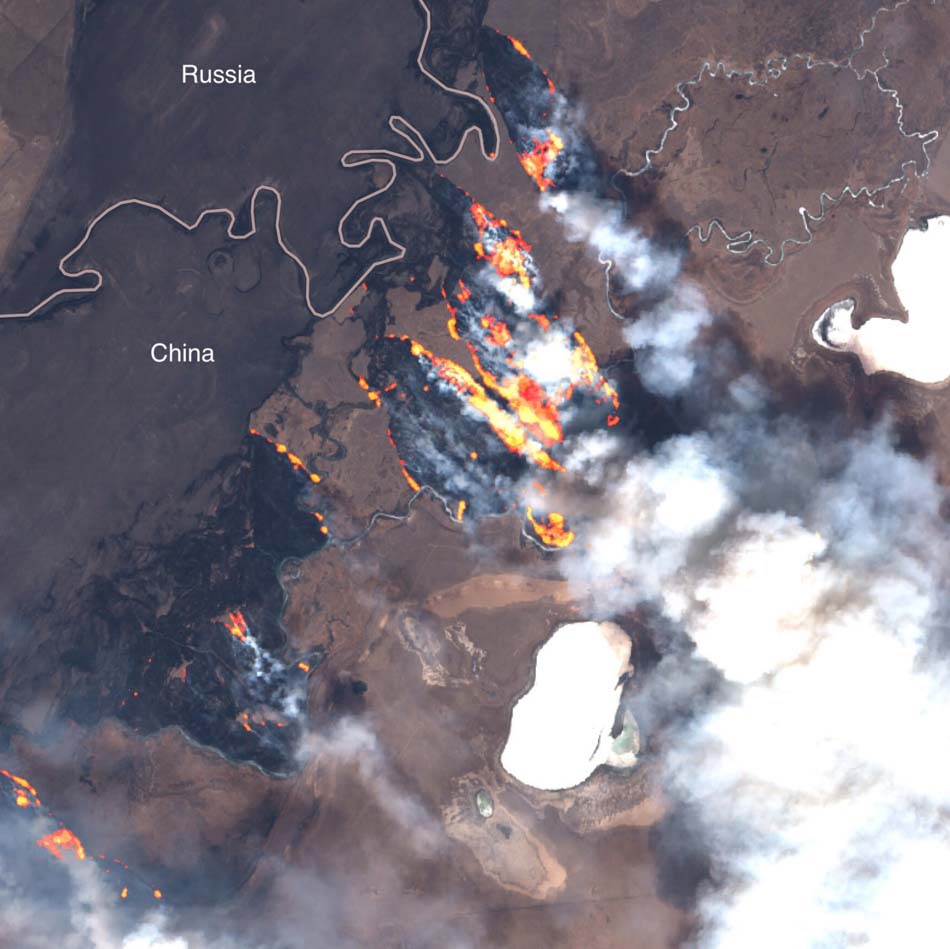
These photos taken by the European Union’s Copernicus satellite show large wildfires that have been burning in grasslands (steppe) in southern Siberia for about a week. A State of Emergency has been declared in the Transbaikal region where about 1,200 personnel are battling the blazes. The province of Khabarovsk is also affected.
The photo below shows interesting burn patterns.
#aerosol UVAI index of #TROPOMI #Sentinel5P shows high amount of absorbing particles, well correlated with the sources of smoke depicted by #Sentinel3 #OLCI (right). Only space instruments with fine pixels allow to detect these events at such a scale. @sentinel_hub pic.twitter.com/Y698E2NPAk
— Julien Chimot, PhD (@JChimotScience) April 21, 2019
At least one large fire has burned from Russia into China.
A paper published in January describes an analysis of 865 civilian and firefighter fatalities in Spain, Portugal, Greece, and Sardinia (Italy) from 1945 through 2016. They found that 77 percent of the fatalities occurred in the months of July, August, and September, and that Sardinia (a large Italian island in the Mediterranean Sea) had the highest rate of fatalities based on their population, 10.01 per million inhabitants.
The leading cause of death was burns and suffocation, followed by health problems including heart attacks, physical trauma, respiratory problems, and exhaustion. Next was aviation accidents and then terrestrial accidents.
All of the images shown here are from the research paper.
A surprisingly high number of fatalities were the result of aviation accidents. Here is an excerpt from the document:
Aircraft-crew fatalities are not negligible, particularly in Spain, where 72 out of the total 96 fatalities reported occurred. This is alarming, although it can be explained to some extent by the heavy use of aerial-firefighting resources in Spain when compared, for example, to Portugal. Aerial firefighting is also heavily applied in Greece, although fatalities in this country are not just the result of the number of flying hours, but also of a host of other parameters still to be investigated and described by specialists. Indeed, an evaluation and a comparison between countries of these other parameters and operational protocols are needed.
Authors of the paper: Domingo M. Molina-Terre´n, Gavriil Xanthopoulos, Michalis Diakakis, Luis Ribeiro, David Caballero, Giuseppe M. Delogu, Domingos X. Viegas, Carlos A. Silva, and Adria´n Cardil.
Among other directives, it urges Forest Service firefighting personnel to use “the best science available” when making decisions.
Air Tanker 912, a DC-10, drops retardant on the north side of the Indian Canyon Fire at 7:18 p.m. MDT July 17, 2016. The objective was for the retardant to serve as a contingency fire line to help protect the town of Edgemont.
The Chief of the U.S. Forest Service, Victoria Christiansen, has issued a Letter of Intent for Wildland Fire for 2019. The “intent” is probably derived from the principle of “leader’s intent” which should be included in a briefing for a fast-moving, dynamic situation so that subordinates can adapt plans and exercise initiative to accomplish the objective when unanticipated opportunities arise or when the original plan no longer suffices.
This is at least the third annual Intent letter and this year’s version is much more specific than last year’s missive. Chief Christiansen’s 2018 letter talked about safety, “protect the people and communities we serve”, the National Cohesive Wildland Fire Management Strategy, the fire funding fix that takes effect in FY 2020, and a few miscellaneous topics.
The letter dated April 11, 2019 hits on most of those but in a more specific way. It is like the difference between Smokey Bear saying “Prevent Forest Fires”, and “Douse your campfire with water, stir it, and douse it again.”
During the last two years the Forest Service has been accused of not doing enough to create a workplace free of harassment. In the hearing on April 9 before the Senate Energy and Natural Resources Committee six minutes was spent on this subject. In the April 11 letter, 78 words are devoted to the issue.
The Chief’s letter implores Forest Service personnel to use “the best science available” when making decisions. It also urges them to implement Administration policies such as “engage early with our partners and communities” before fires start, “use active management that focuses on wildfire risk reduction, forest products and restoration”, and “use wildland fire to achieve desired ecological conditions”.
Below are excerpts from the Chief’s 2019 Letter of Intent for Wildland Fire:
“…As I look ahead to the remainder of the 2019 fire year, it is more important than ever we remain grounded in our core values of safety, diversity, conservation, interdependence and service, while we foster a safe, respectful workplace where everyone is valued for their contributions. Everything we do—every part of our mission—depends on creating a workplace where each one of us is able to thrive in our work, free from harassment and safe from harm.
“For wildfire response, let me be clear: that we will continue to implement incident response strategies and tactics that commit responders to operations where and when we understand the risks responders may face and where they can be most successful. We will deploy our people under conditions where we protect important values at risk. These decisions will be based on risk-informed trade-off considerations, looking at all available tactics and opportunities, while maintaining relationships with the communities we serve. Each of us must remain committed to “stop, think and talk” before “acting”.
[…]
“With this in mind, I issue this direction to ALL employees. Each of you has a role to play in carrying out our key agency priorities of reducing wildfire risk and improving forest conditions. As you continue to focus on work that delivers successes in these priority areas in 2019, these principals apply:
We will maintain our commitment to improve the wildland fire system to one that more reliably protects responders and the public, sustains communities and conserves the land.
We will be responsible for ensuring sound, risk informed decision making that takes into account the best science available and most appropriate use of the right tools at the right time.
We will engage early with our partners and communities to strengthen relationships even where priorities may differ, to ensure we are sharing risk before fires start, to work towards achieving our shared goals and missions.
We will use active management that focuses on wildfire risk reduction, forest products and restoration, engaging in cross-boundary collaboration to set landscape-scale treatment priorities with our partners.
We will also use wildland fire to achieve desired ecological conditions where possible and where it makes sense, setting that intention together with our partners.”
(end of excerpt)
Our opinion:
As Chief Christiansen has pointed out in this new letter and other venues, she wants firefighters to “engage fires where they can be most successful.” Left unsaid is the fact that a warming climate has resulted in a longer fire season and more acres burned while the constant dollars allocated for wildland fire management decrease. Even though the USFS fire budget remains about the same, the agency has been told to expect an overall five percent reduction next fiscal year. Inflation takes a toll, wages increase, air tankers are more expensive, firefighting equipment costs more, and the flat budget for fire does not go as far. Finding help on large fires from the “militia”, non-fire agency employees who help when and if they are available, becomes more of a challenge. So, as we have seen in recent years, too often initial attacks or extended attacks fail — more fires become megafires.
And the list of fires where firefighters can’t be successful grows. Local residents look at the smoke column and ask, “Where are the firefighters?”
Researchers hope to use the information to help wildland firefighters find the best escape routes
Firefighters on the Whitetail Fire in the Black Hills of South Dakota, March 8, 2017. Photo by Bill Gabbert.
Fitness tracking data from 29,928 individuals representing 421,247 individual hikes, jogs, and runs on trails in and around Salt Lake City was used to calculate travel rates on slopes. Researchers hope their findings can be used to help develop a smart phone app that would suggest to wildland firefighters the best escape route if faced with a possible entrapment.
They undertook the study basically because it had not been done before using a large amount of raw foot travel data and the information is needed to develop an app that can enhance the situational awareness of firefighters. Some preliminary work was done two years ago by some of the same researchers. They used Light Detection and Ranging (LiDAR) technology to analyze the terrain slope, ground surface roughness and vegetation density of a fire-prone region in central Utah, and assessed how each landscape condition impeded a person’s ability to travel. At the time, Department of Geography professor and co-author of that study, Philip Dennison, said, “Finding the fastest way to get to a safety zone can be made a lot more difficult by factors like steep terrain, dense brush, and poor visibility due to smoke. This new technology is one of the ways we can provide an extra margin of safety for firefighters.”
The researchers felt they needed more accurate travel rate data to build on their previous work to calculate the best escape routes.
The data used in this study were obtained from Strava, a popular fitness tracking and social networking app that allows users to track their movement while hiking, running, and cycling using GPS on phones or fitness tracking devices to compare their travel rates to their peers. The company aggregates and anonymizes the data and makes them available to planning organizations and researchers. The information used in the study represents hiking, jogging, or running a combined 81,000 miles.
“This will revolutionize our understanding with how terrain affects pedestrian movement,” said Michael Campbell, assistant professor at Fort Lewis College and lead author of the study. “From a firefighter perspective, under normal conditions a fire crew may have ample time to hike to a safety zone, but if the sh*t hits the fan, they’re going to have to sprint to get there. We tried to introduce predictive flexibility that can mimic the range of conditions that one might need to consider when estimating travel rates and times.”
“Calculating how quickly people move through the environment is a problem more than a century old. Having data from such a large number of people moving at all different speeds allowed us to create much more advanced models than what’s been done before,” said Phil Dennison. “Any application that estimates how fast people walk, jog, or run from point A to point B can benefit from this work.”
From the study. Click to enlarge.
According to the results of the study, a slow walk on a flat, 1-mile (1.6 km) trail takes about 33 minutes on average, whereas that same level of exertion on a steep, 30 degree slope will take about 97 minutes. On the other end of the spectrum, a fast run on a flat, 1-mile trail takes about six minutes, as compared to 13 minutes up a 30 degree slope. People move most rapidly on a slightly downhill slope, and travel rates were faster for downhill than uphill movement. For example, walking down a steep slope of 30 degrees was done at the same speed as walking up a slope of 16 degrees.
“For wildland firefighters, the slope of the terrain is largely what determines the most efficient path to safety, and dictates how long it’s going to take,” Mr. Campbell told Runner’s World. “Our goal is to provide firefighters with the ability to press a button on their phone and not only map the best route to safety, but also provide a travel time estimate.”
Of course hiking times on established trails is not always completely transferable to the situations faced by wildland firefighters. Presumably ground surface roughness and vegetation density from the earlier work will be factored in when developing the app to make the results more realistic.
Starting this month, the geographers will apply their new models to wildland firefighters. During their spring training, nearly a dozen fire crews in Utah, Idaho, Colorado and California will use GPS trackers to record their movements and log their travel rates. This will allow them to better understand the travel rates of the unique firefighter population, who are often traversing rugged terrain, working long hours, and carrying heavy packs.
Map showing heat detected by satellites during the last seven days. Updated at 1 p.m. CDT April 19, 2019.
The Kansas Department of Health and Environment (KDHE) says the average annual acreage burned in the Flint Hills during the prescribed fire season was almost matched over the past month. Most of the burning is related to agriculture, improving pastures or preparing crop lands.
Almost 2.1 million acres of grassland were treated with fire between March 15 and April 12. KDHE said roughly 2.5 million acres are burned annually.
The reporting time period includes 21 counties in Kansas and Oklahoma.
KDHE said burns from April 8-9 caused six air quality exceedances across parts of Kansas, Missouri and Oklahoma. There were no air quality exceedances due to burns last year.
Thanks and a tip of the hat go out to Matt. Typos or errors, report them HERE.