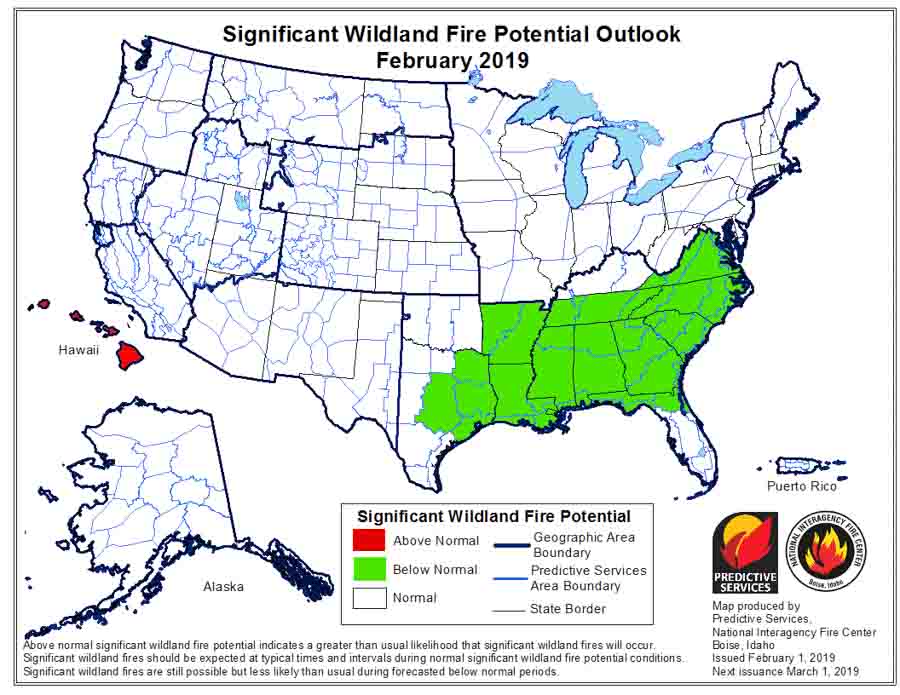
Wildfire potential, February through May

Wildfire potential in United States is expected be normal or below normal in most areas during the coming four months

February wildfire potential outlook

After missing the January edition of the monthly fire potential outlook due to the shutdown of the Departments of Interior and Agriculture, today the Predictive Services section at the National Interagency Fire Center issued their Wildland Fire Potential Outlook for February through May. The data represents the cumulative forecasts of the ten Geographic Area Predictive Services Units and the National Predictive Services Unit.

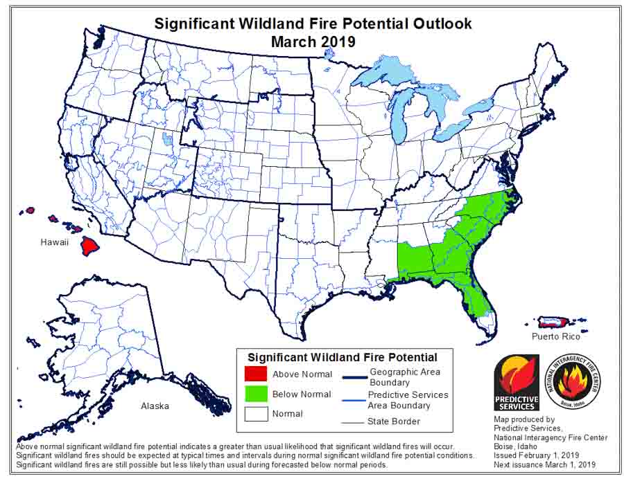
If their analysis is correct, the wildfire potential for United States will be normal during the coming four months, except it will be below normal for most of the South and above normal for Hawaii.

The format of the written outlook has recently evolved. Verbiage about past weather and fuel conditions over the previous 30 to 60 days is more prominent along with descriptions for what is normal for the present and near future. Forecasts for what land managers will be faced with in the coming months are still in the document, and can be found in the sections for each geographic area.

Below:

  • An excerpt from the NIFC narrative report for the next several months;
  • More of NIFC’s monthly graphical outlooks;
  • NOAA’s three-month temperature and precipitation forecasts; and,
  • Drought Monitor.

Here is one section that discusses El Niño:

“Impacts from a fading El Niño event on late winter and spring weather conditions vary. They typically result in below average snowpack across the northwestern quarter of the nation and above average snowpack across the central portion of the West. The southern tier of the nation tends to experience wetter than average conditions, except possibly across West Texas which can be drier than average. The northern tier of the nation can be warmer than average which would promote a faster melting rate of the snowpack in the mountains across the Pacific Northwest and the Northern Rockies.”

March wildfire potential outlook

Continue reading “Wildfire potential, February through May”

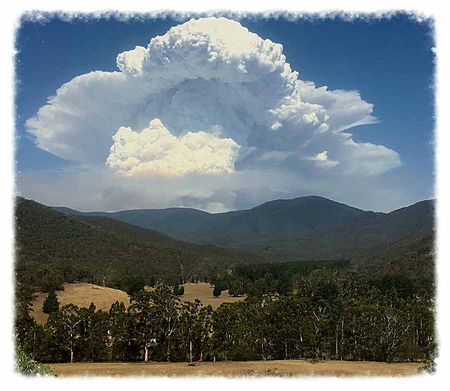
Pyrocumulus cloud near Timbarra, Victoria

Pyrocumulus Australia wildfire bushfire
Pyrocumulus north of Timbarra, Victoria, Australia. Murray King took the photo 30km west of the fire in Bindi, East Gippsland on January 25, 2019 at 5:30 p.m.

Murry King sent us this photo of the pyrocumulus cloud over a bushfire north of Timbarra, Victoria, Australia. He got the shot from a point 30km west of the fire in Bindi, East Gippsland on January 25, 2019 at 5:30 p.m.

Thanks Murry.

Here is the latest information about the fire from Vic Emergency:

This Advice message is being issued for Timbarra, Gillingall, Gelantipy, Butchers Ridge, W-Tree, Murrindal, Buchan and Buchan South.

There is an active bushfire north of Timbarra and Gillingall and west of the Gelantipy Road between Butchers Ridge and W-Tree that is not yet under control.

We have now started igniting a back burn on the south eastern corner of the fire near W-Tree, along Hodges Track and Dawson Track. If conditions are favourable, we will continue to extend the back burn later today.

There will be increased smoke in this area. Crews and machinery continue to strengthen containment lines around the fire perimeter.

Here is another photo of the pyrocumulus taken around the same time.

Grass fire in Tate County Mississippi

Posted on Categories UncategorizedTags
fire Yellow Dog Road Senatobia Mississippi
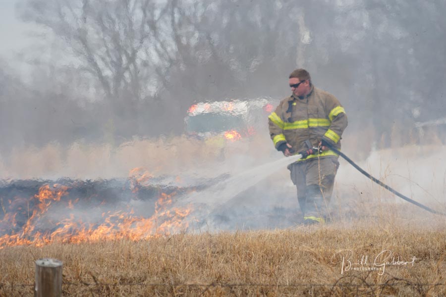
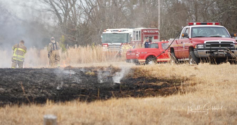
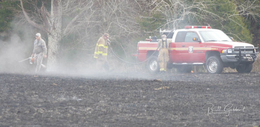
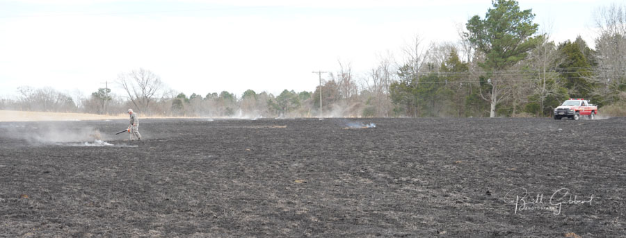
Fire near Yellow Dog Road in Tate County, Mississippi, January 30, 2019. Photo by Bill Gabbert. Click to enlarge.

A grass fire burned a couple of acres today near a home at Yellow Dog Road in Tate County Mississippi before Senatobia Fire & Rescue knocked it down.

fire Yellow Dog Road Senatobia Mississippi
Fire near Yellow Dog Road in Tate County, Mississippi, January 30, 2019. Photo by Bill Gabbert.
fire Yellow Dog Road Senatobia Mississippi
Fire near Yellow Dog Road in Tate County, Mississippi, January 30, 2019. Photo by Bill Gabbert.
fire Yellow Dog Road Senatobia Mississippi
Fire near Yellow Dog Road in Tate County, Mississippi, January 30, 2019. Photo by Bill Gabbert.

Judge to PG&E: Safety is not your number 1 thing

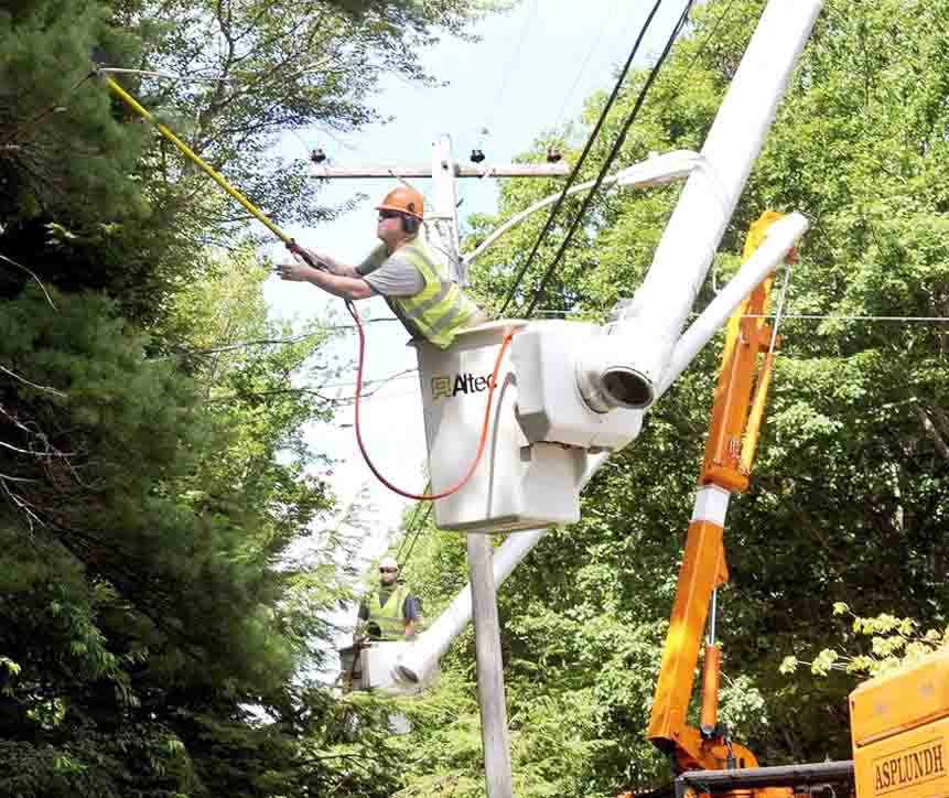
trim trees power line
Mohave Electric Coop photo.

On Wednesday, the day after Pacific Gas and Electric officially filed for bankruptcy protection, a federal judge berated the company for wildfires started by their electrical distribution equipment.

“To my mind, there’s a very clear-cut pattern here: that PG&E is starting these fires,” Judge William Alsup said. “What do we do? Does the judge just turn a blind eye and say, continue your business as usual. Kill more people by starting more fires.'” And later, “Safety is not your number one thing”.

PG&E has been on criminal probation for years following the 2010 gas line explosion in the San Francisco Bay Area that killed eight people and destroyed 38 homes. Judge Alsup is overseeing the company’s probation.

Investigators have attributed more than 1,500 fires to PG&E power lines and hardware between June 2014 and December 2017, according to the Wall Street Journal (subscription).

Below is an excerpt from KCRA:

[Alsup] proposed earlier this month as part of PG&E’s probation that it remove or trim all trees that could fall onto its power lines in high-wind conditions and shut off power when fire is a risk regardless of the inconvenience to customers or loss of profit. Alsup said his goal was to prevent PG&E equipment from causing any wildfires during the 2019 fire season.

PG&E wrote in a court filing last week that the judge’s proposals would endanger lives, could cost $75 to $150 billion to implement, and require the hiring of 650,000 workers.

From the Merced Sun Star:

Alsup, however, was clearly frustrated by PG&E’s explanations. “I don’t buy that there isn’t enough people,” the judge said, adding that PG&E is moving too slowly and wasted billions paying dividends to shareholders instead of removing trees and improving its system.

What does California law require?

The California Public Resources Code section 4293e requires all vegetation to be removed that is within four to 10 feet of a power line, depending on the how many volts it is carrying. The Code also requires the removal of “dead trees, old decadent or rotten trees, trees weakened by decay or disease, and trees or portions thereof that are leaning toward the line which may contact the line from the side or may fall on the line.”

PG&E acknowledged this law and others in the November 2, 2017 edition of their “Currents” publication. The  original copy on the internet has been removed and we were unable to find it — except on the Wayback Machine Internet Archive that was captured on November 20, 2017.

November 2, 2017 edition of PG&E's "Currents"
November 2, 2017 edition of PG&E’s “Currents”. Screen capture from Wayback Machine on November 20, 2017.

Our Opinion

It seems odd, to say the least, that PG&E now seems surprised and outraged that a judge is suggesting that the company “remove or trim all trees that could fall onto its power lines in high-wind conditions”, which is exactly what the law requires, and which was acknowledged by the company in their newsletter three weeks after their electrical system started a dozen fires in Northern California on October 8, 2017, according to CAL FIRE investigators. The agency is also looking into PG&E power line equipment failures that may have caused the Camp Fire on November 8, 2018. Over 40 people died in the Northern California fires, and 86 perished in the Camp Fire which also destroyed more than 14,000 homes.

Update on the wildfires in Tasmania

Numerous bushfires are burning in the island state south of the Australia mainland

satellite photo tasmania wildfires
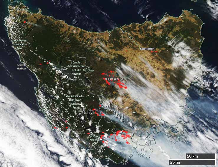
Satellite photo showing smoke streaming from the wildfires in Tasmania, January 29, 2019. The red dots represent heat. Click to enlarge.

Firefighters in Tasmania has been battling large bushfires for the last month and conditions are not improving. Several large air tankers and helicopters from the Australian mainland, as well as firefighters, have flown across the Bass Strait to provide assistance.

Below are excerpts from an article from ABC Australia published at about 6 a.m. PST US January 30:

Communities in the Central Plateau also remain on high alert with gusty winds pushing flames towards properties.

More than 500 firefighters are battling nearly 1,500 kilometres of fire fronts across Tasmania but the main fire fight is in the Huon Valley, south of Hobart.

The Tasmania Fire Service said the Huon Highway near Geeveston was expected to be impacted by fire tonight, with the possibility that communities further south could be cut off for an extended period of time.

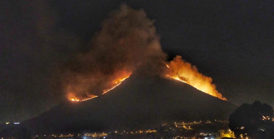
Wildfire burns across Lion’s Head Mountain

wildfire lions head mountain
Wildfire on Lion’s Head Mountain near Cape Town, South Africa. Photo: EBU Social Newswire

A wildfire near Cape Town, South Africa spread across Signal Hill and Lion’s Head forcing a few residents to evacuate. It also burned portions of  Table Mountain National Park, damaging infrastructure which will require the popular tourist destination to remain closed until repairs can be made.

Thanks and a tip of the hat go out to MrCapt. Typos or errors, report them HERE.