President threatens to cut funding for California wildfires

President Trump on Wednesday seemed to threaten to cut the federal government’s funding for fighting wildfires in California. During a Cabinet meeting exchange with Secretary of Agriculture Sonny Perdue, who oversees the U.S. Forest Service, Mr. Trump said about the fires in California,  “…we’re just not going to continue to pay the kind of money that we’re paying…”, which he said was “hundreds of billions of dollars”.

It is not clear exactly what funding would be cut. About 20 percent of the land in California is managed by the Forest Service, where many of the largest fires occur. It is hard to see how cutting the Forest Service budget would improve the situation. The state has responsibility for suppressing vegetation fires in many rural areas of California.

Any state can apply to the Federal Emergency Management Agency (FEMA) for a Fire Management Assistance Grant (FMAG) which  may provide federal funding for up to 75 percent of eligible firefighting costs.  The grant is intended to assist in fighting fires that threaten to cause major disasters.  Eligible costs covered by FMAGs can include expenses for fire camps, equipment use, materials, supplies, mobilization, and demobilization activities attributed to fighting the fire.

Some of the California fires in 2018 for which FMAGs were approved included the Carr Fire near Redding, Pawnee Fire in Lake County, Cranston Fire in Riverside County, and the Mendocino Complex of Fires in Lake County near Clear Lake.

Also in 2018 FEMA declared the Carr Fire to be a “major disaster” which enabled grants to individuals for temporary housing, home repairs, low-cost loans to cover uninsured property losses, and other programs to help individuals and business owners recover from the effects of the fire. Major disasters are often declared for recovery from hurricanes, floods, and other natural disasters.

Fact check
cost fires california
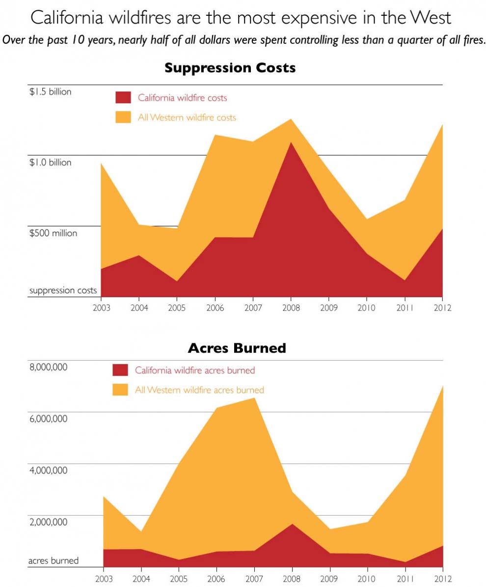
On average from 2003-2012, California wildfires had 44 percent of all reported suppression costs in the western 11 states (based on fiscal fire years, October 1 – September 30). Only 24 percent of acres burned were in California, on average, over the same time. Click image to enlarge. Credit: Climate Central.

Twice during the two-minute discussion about the cost of fires in California, Mr. Trump said fires in the state are costing the country “hundreds of billions of dollars”. Using data compiled by the National Wildfire Coordinating Group, Climate Central created the graphs above. We extracted from the graphic the approximate yearly costs and found that the average annual costs of suppressing fires in California from 2003 through 2012 was approximately $300 million. Only one time during that 10-year span did suppression costs exceed $1 billion — in 2008 when about $1.1 billion was spent in the state. If that annual average suppression cost remained the same it would take 180 years to total $200 billion. Mr. Trump’s statement about the costs of suppressing fires in California is off by a factor of approximately 180.

These costs do not include other expenses that may be authorized by a major disaster declaration, like on the Carr Fire.

It is true that the cost per acre of wildfires in California is high. Some of the reasons include the high costs of firefighting resources in the state, and the proximity of values at risk such as homes and infrastructure.

Video and a transcript of the October 17 Cabinet meeting discussion about the cost of wildfires in California.


Secretary of Agriculture Sonny Perdue:

“You talked about the forest fires. Now we are permitting and cleaning up these forests so we will reduce the threat of forest fires as well as creating jobs in these communities.”

President Trump:

“They ought to do that in California by the way.”

Secretary Perdue:

“Yes sir.”

President Trump:

“California’s a mess. We’re giving billions and billions of dollars for forest fires in California. There’s no reason for those fires to be like they are. They are leaving them dirty, it’s a disgraceful thing. Old trees are sitting there rotting and dry and instead of cleaning it up they don’t touch ’em. They leave ’em. And we end up with these massive fires that we’re paying hundreds of billions of dollars for — to — fix, and the destruction is incredible.

“So I think California oughta get their act together and clean up their forests and manage their forests because it’s disgraceful.

“What’s happening should never happen. I go all over the country. When I meet with governors the first thing they say is there’s no reason for forest fires like that in California.

“So I say to the Governor, or whoever is going to be the Governor of California, better get your act together cause California we’re just not going to continue to pay the kind of money that we’re paying because of fires that should never be to the extent.

“They were telling me in a couple of states I won’t even mention their names, it’s like a flash, some grass will burn. It will be over in minutes. They’ll lose two acres, three acres at the most. They won’t even lose that. And here we are with thousands of acres and billions and billions of dollars every year. It’s the same thing every year.

“And they don’t want to clean up their forests because they have environmental problems in cleaning it up. It should be the opposite. Cause you’re going to lose your forest. You’re losing. But it’s costing our country hundreds of billions of dollars because of incompetence in California.

“The people, I’m speaking now for the people of California. They don’t want to see this happen. They’re getting destroyed. And it’s hurting our budgets, it’s hurting our country and they just better get their act together.”

Report of “extreme spotting” 6 miles ahead of Klondike Fire

(Originally published at 5:34 a.m. PDT October 17, 2018)

Typically by mid-October firefighting agencies in Oregon have downsized their ranks of seasonal firefighters and are preparing to enter winter mode. But the Klondike Fire west of Grants Pass, after being dormant for weeks, exploded back to life on October 14 and in a big way. Within a matter of hours it burned an additional 4,968 acres to bring the total up to 172,287 acres.

According to an article in the Mail Tribune it was transporting burning embers into the atmosphere that started fires six miles out ahead of the flaming front:

“Extreme spotting” propelled fine embers up to six miles ahead of the main fire, dropping the live ash right between firefighters’ tents and close to people’s homes.

“We even had to move our own fire camp,”  [information officer Kale] Casey said.

The map below shows spot fires detected by an infrared mapping flight.

map Klondike Fire
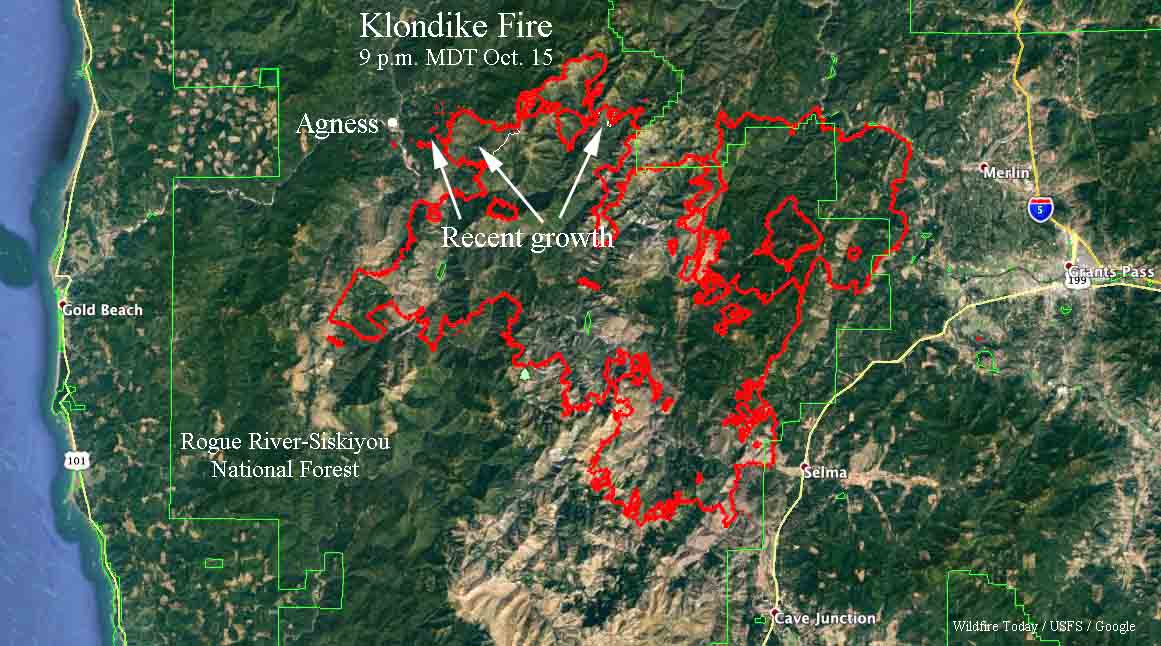
The red line on the map was the perimeter of the Klondike Fire at 9 p.m. October 15, 2018. The white line shows where the perimeter was before the October 14-15 additional growth. Click to enlarge.

The Incident Management Team posted an update on Tuesday October 16:

Fire personnel focused all efforts to ensure that Sunday’s wind driven spot fires did not damage any of the homes in the Oak Flats, Spud Road and Agness area. Fire managers estimate that the weekend wind event resulted in approximately 5,000 acres of new growth to the west of the primary containment lines. Level 3 evacuations remain in effect for these areas while fire crews and engines work to construct and link together new and existing containment lines.

The Oregon State Fire Marshal’s five structural task forces that arrived yesterday have split into day and night shifts to ensure that all homes under evacuation are protected. These resources include twenty engines and five water tenders with firefighters from thirty-three different fire agencies from across the state.

Fire behavior moderated significantly yesterday as the 30 mph winds over the weekend diminished significantly, allowing fire firefighters to attack spot fires directly. Containing the remaining spot fires east and west of the Illinois River and west of the 3577 Road is the primary objective for all fire personnel.

Washington DNR requests a record $55 million budget

The agency wants to convert 30 seasonal engine Captain jobs into year-round permanent positions

Washington Commissioner of Public Lands Hilary Franz unveiled on October 10 the largest budget request of its kind in state history: a $55 million Department of Natural Resources proposal for fighting wildfires and maintaining healthier forests in Washington.

The 2019-21 budget package, which already has bipartisan support from members of the Legislature’s Wildfire Caucus, would transform DNR’s firefighting strategy and reduce that hazards that unhealthy forests pose to Washington communities.

This year, DNR responded to about 1,700 wildfires – second only to the number of wildfire responses in 2009. Smoke from this year’s fires at times gave Washington the worst air quality in the world, and numerous fires forced families to evacuate their homes.

Washington Commissioner of Public Lands Hilary Franz
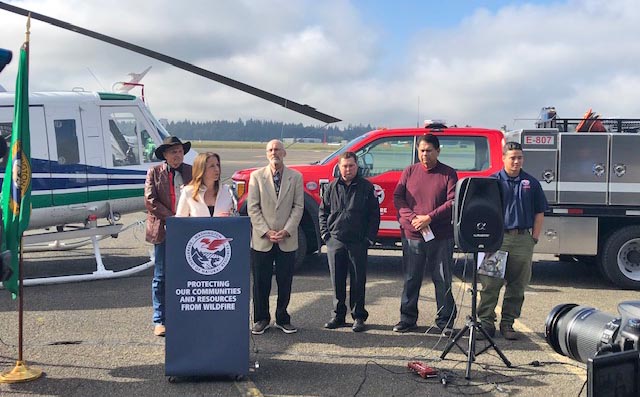
Washington Commissioner of Public Lands Hilary Franz speaks about her budget request October 10, 2018 at the Department of Natural Resources helicopter maintenance hangar in Olympia, Washington.

“We need bold, forward-thinking investments to reduce wildfires. Inaction is not an option,” Franz said. “It’s time to come together to invest in strategies that keep wildfires small and our skies clear of smoke, and I look forward to working with the governor and the Legislature to ensure we have the resources we need to keep our communities healthy and safe.”

Wildfire fighting and prevention

The biennium budget request includes nearly $12 million to transform 30 seasonal engine Captain jobs into year-round permanent positions. This would help retain seasoned firefighters at DNR and provide a staff to carry out critical forest health treatments, such as prescribed burning, during the offseason. The vast majority of DNR’s firefighting force is seasonal (only 43 firefighters work full time), prompting many firefighters to take their skills elsewhere.

“I love serving my community as a wildland firefighter,” said Tommy Matsuda, a seasonal firefighter at DNR. “But the part-time nature of the job makes it hard to sign up year after year. I would gladly stay on full time performing forest health work in the offseason if I was able.”

The agency’s firefighters would also receive more training to deal with increasingly complex wildfire seasons under the commissioner’s budget plan, to the tune of $2.2 million in the 2019-21 biennium. They would receive two additional helicopters – increasing their helicopter fleet to nine and helping them respond more rapidly to fires.

Additionally, more than $4.8 million would grow the firefighting force supplied by Washington’s prison system – from 300 to 380 workers – allowing incarcerated people to learn firefighting and forestry skills while reducing the state’s firefighting costs. The budget also would provide $100,000 to improve emergency communications and $234,200 to help assess landslide risk in areas affected by wildfire.

These requests support the commissioner’s Wildland Fire Protection Strategic Plan to make the fundamental changes necessary to stop and prevent uncharacteristically large wildfires.

“As a fire chief and incident management team member in a community impacted by wildfire, I know we need more resources on the ground,” Spokane County Fire District 9 Chief Jack Cates said. “With more full-time firefighters and air resources, the Department of Natural Resources will be better able to assist us in protecting endangered communities like Spokane County.”

Franz made her announcement alongside state Reps. Larry Springer, D-Kirkland, and Tom Dent, R-Moses Lake, as well as Confederated Tribes of the Colville Reservation Chairman Rodney Cawston, Cowlitz 2 Fire & Rescue Chief Dave LaFave, and Matsuda.

“The facts are simple: When fire is running across the landscape, it’s terrifying. It doesn’t matter if it’s 15,000. It doesn’t matter if it’s 80,000 acres. It’s terrifying,” said LaFave, a member of the the state’s Wildland Fire Advisory Council and the Washington Fire Chiefs Association. “We want to see these initiatives move forward. We want to see a different decision today, so there’s a different outcome tomorrow.”

Because people cause 90 percent of all wildfires, teaching the public about wildfire prevention is another key part of the commissioner’s budget.

It would invest nearly $2 million in the creation of seven public-outreach specialists scattered across the state, and it includes $4.2 million for DNR’s Landowner Assistance Program. This program helps private forestland owners reduce the wildfire threat on their lands.

Restoring resilient, healthy forests

To get at the core of the problem, Franz’s budget request includes more than $5.7 million to speed up forest health restoration by creating a division solely committed to forest health. The proposal also asks for $17.7 million in capital budget funds to treat more than 32,000 acres of state, federal and private forests in targeted, high-risk areas.

And more than $724,000 in the proposal would dedicate two employees to manage the federal contracts, finances, and grants necessary to carrying out restoration treatments on federal lands. DNR and the U.S. Forest Service work together through the Good Neighbor Authority agreement to work toward their forest health goals.

“Wildfire doesn’t respect property boundaries,” Cawston said. “By increasing resources for our state’s wildland firefighters, we decrease the risk that wildfires pose to tribal communities and private property owners. This is a win-win for Washington.”

Warm, dry, breezy weather awakens Klondike Fire in Southwest Oregon

After being relatively quiet for weeks the fire jumped firelines Sunday requiring evacuations in Agness

(UPDATED at 5:10 a.m. PDT October 16, 2018)

map Klondike Fire
The red line on the map was the perimeter of the Klondike Fire at 9 p.m. October 15, 2018. The white line shows where the perimeter was before the October 14-15 additional growth. Click to enlarge.

The map of the Klondike Fire above is a result of mapping by a fixed wing aircraft at 9 p.m. PDT October 15. The new growth on October 14 and 15 added another 4,968 acres to bring the total up to 172,287 acres.

The weather forecast for the fire area on Tuesday (Agness, OR) predicts a high temperature around 80, relative humidity in the teens, and 5 mph east to northeast winds. The area is not under a Red Flag Warning.


Klondike Fire in southwest Oregon
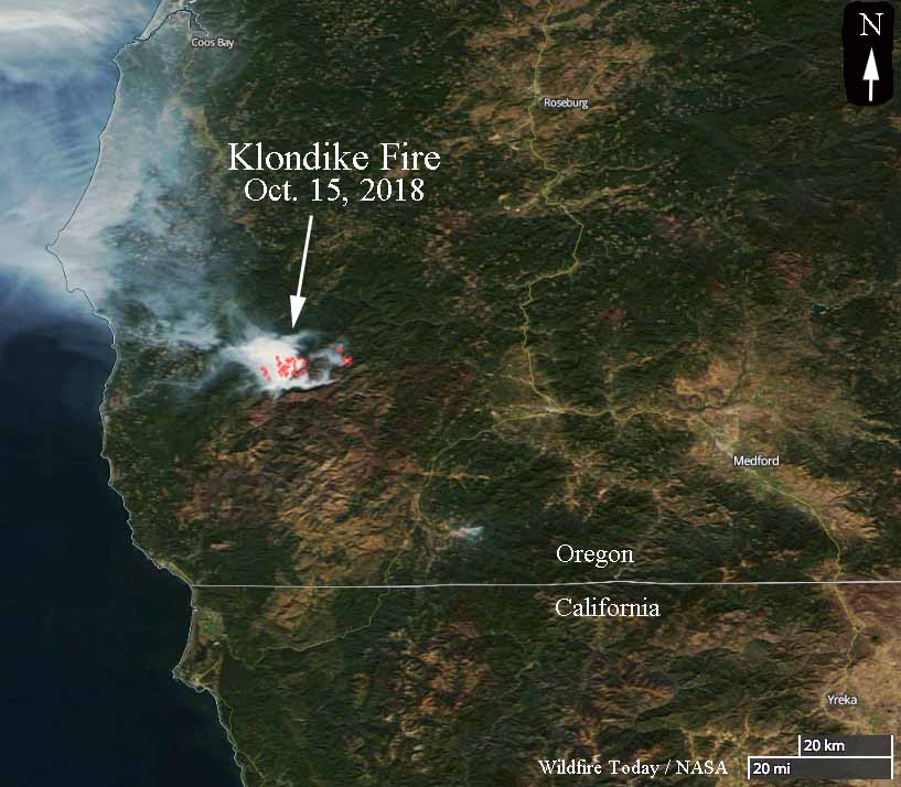
A satellite photo taken October 15 showing heat (the red dots) and smoke on the Klondike Fire in southwest Oregon.

The Klondike Fire had been quiet for weeks until warm, dry, breezy weather on Sunday brought it back to life, burning thousands of acres outside the firelines and requiring evacuations in the small town of Agness 20 miles northeast of Gold Beach, Oregon. The Sheriff’s Office in concurrence with fire officials  made the determination that evacuations were appropriate for residents north of the Rogue River and in the areas of Oak Flat, Spud Road, and along the 33 road in Agness.

Incident Management Teams had released 171 fire personnel over the last seven days, to bring the total down to 316. The 167,423-acre fire had not increased in size for over a week. Approximately 250 additional resources have been requested, including aircraft, engines, and Type 1 Interagency Hotshot Crews (IHC). Northwest Incident Management Team 7 (NWIMT7) assumed command of the October 14, 2018 at 8:00 p.m.

The Oregon Governor has declared the Klondike Fire to be a “conflagration”which allows the State Fire Marshal to mobilize firefighters and equipment to assist local crews.

map Klondike Fire
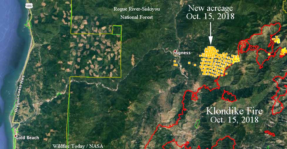
The red line on the map was the perimeter of the Klondike Fire the last time it was mapped, on October 12, 2018. The yellow dots represent heat detected by a satellite at 4:54 a.m. PDT October 15, 2018. We will update this map when new data becomes available.

At 2 p.m. Monday afternoon a weather station near Agness recorded 73 degrees, 10 percent relative humidity, and 2 mph SSE winds. The maximum wind gust over the previous 24 hours was 20 mph Sunday evening.

Our very unofficial analysis of Sunday’s activity indicates that approximately 4,500 additional acres burned on the northwest side of the fire east of Agness. Firefighters have requested a Monday night infrared mapping flight to get a more accurate assessment.

Strong, dry winds hit California

PG&E has proactively shut off power to tens of thousands of customers to prevent vulnerable power lines from starting fires

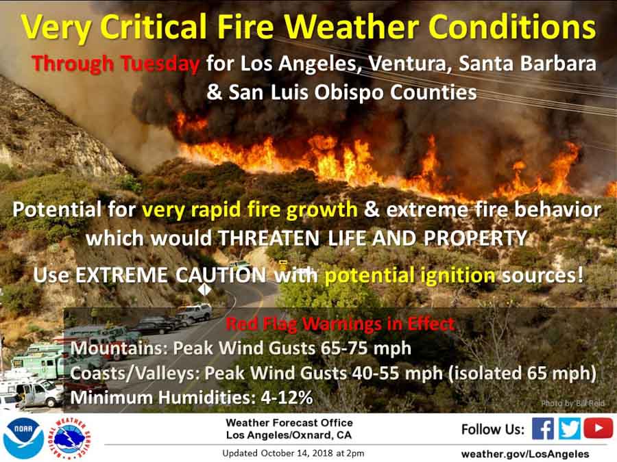
Red Flag Warnings CaliforniaWith a forecast for strong Santa Ana winds that are predicted to gust above 65 mph in some areas firefighters and utility companies are making preparations — some to prevent fires and others to suppress them after they start.

Sunday night Pacific Gas and Electric turned off the power for 59,000 of their customers in areas of six Northern California counties — Amador, Calaveras, El Dorado, Lake, Napa, and Sonoma — reasoning  that their electricity infrastructure is vulnerable to the strong winds, which could ignite fires.

PG&E power shut off traffic signalsPG&E sent out a tweet asking residents of those areas to “Please be safe at intersections where traffic signals are out”.

In the south part of the state Southern California Edison warned 130,000 customers they may shut off power in parts of Ventura, Los Angeles, Orange and San Bernardino counties.

The National Weather Service has issued Red Flag Warnings for large areas of southern California through 10 p.m. Tuesday for 25 to 45 mph winds that could gust in some areas at 65 or 75 mph with humidities ranging from 4 to 12 percent.

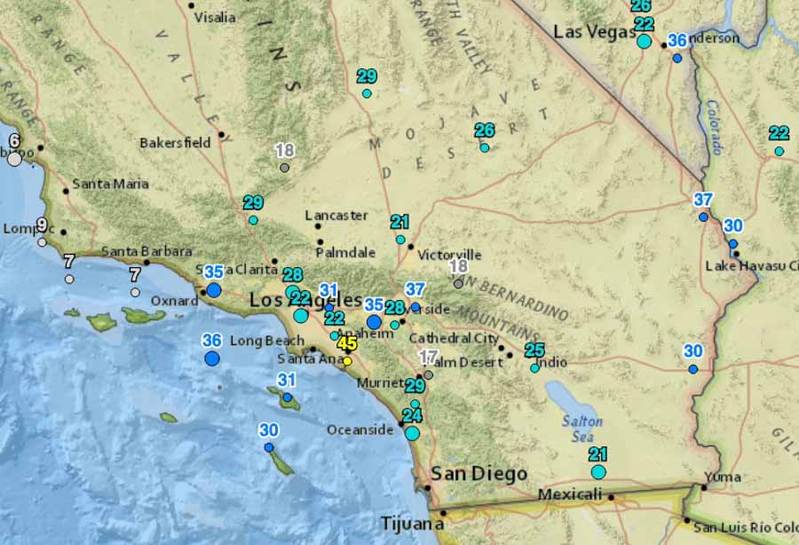
Wind gusts at 9 a.m. PDT October 15, 2018 California
Wind gusts at 9 a.m. PDT October 15, 2018.

Several Red Flag Warnings are in effect in areas of Northern California until mid-day Monday or 1 a.m. Tuesday for 15 to 25 mph winds gusting at 35 to 45 mph along with very low humidities.

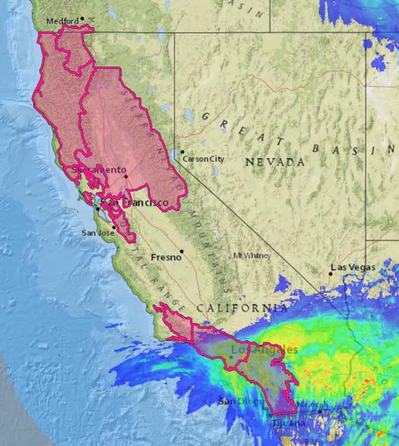
Many areas in Southern California from Los Angeles to San Diego received over half an inch of rain Friday which could have an effect on the spread of wildfires until the fine fuels are dried by the winds.

Red Flag Warnings precipitation california
Red Flag Warnings in California for October 15 with an overlay showing precipitation that occurred October 12-13, 2018.

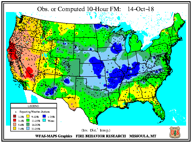
On Sunday the moisture content of ten-hour time lag fuels in those areas was still relatively high, at 11 to 15 percent.  Ten-hour fuels include vegetation 0.25-inch to 1-inch in diameter.

10-hour time lag fuel moisture
Moisture content on October 14 of 10-hour time lag fuels (less than one-half inch in diameter).

But Northern California was a different story with 3 to 4 percent moisture content. These numbers will be lower at both ends of the state after a day or two of strong, dry winds.

Technology increasingly being used by firefighters in Oregon

camera detect wildfire Oregon
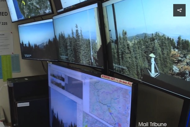
Cameras are used to detect wildland fires in a detection center in Oregon.

(Originally published at 9:51 p.m. PDT October 13, 2018)

Wildland firefighters in Oregon and other locations are increasingly using technology to streamline dispatching, map fires, communicate, detect fires, and enhance situational awareness. An article at the Mail Tribune covers advances in fire detection, drones, mapping, and satellite imagery. Below are two excerpts.

…It’s called the detection center, and ODF employees who man its viewing stations are constantly on the lookout for just-sparked wildfires.

“Typically, what we’re looking for are slight movements,” [Chris] James says while gesturing at a bank of monitors that displays multiple views of the region’s hazy, forested landscape.

Each monitor contains four pictures that rotate through on the screens and are spaced over time, giving ODF workers the ability to see fires.

“We’re looking at those pictures for any sign that we don’t recognize, that we haven’t seen before, and that keys us up on smoke,” says James, a detection center supervisor.

The Bureau of Land Management utilized drone technology for a variety of purposes, including infrared heat detection, mapping, and scouting certain areas of terrain for possible fire lines. Unrelated to surveillance — but no less interesting — the agency utilized some of the unmanned aircraft to haul in supplies. The drones also were used for burnout purposes, dropping ping pong balls … which triggered a chemical reaction that ignited the plastic spheres.

We checked with Gil Dustin who leads the Bureau of Land Management Unmanned Aircraft Systems program. He said the federal land management agencies have not used drones to haul supplies. The aircraft they have been flying can only carry a few pounds at most. One day they may be resupplying firefighters with drinking water, food, fire hose, pumps, and chain saw fuel, but we are not there yet.

Mr. Dustin said years down the road helibases are going to look very different compared to what we are seeing today.

Thanks and a tip of the hat go out to Kelly.
Typos or errors, report them HERE.