Six firefighters injured escaping from sudden flare up

The six firefighters on the Mendocino Complex of Fires in Northern California had to run for a mile through unburned vegetation when an unexpected wind shift caused explosive fire growth

The following “72-Hour Report” was distributed by the Wildland Fire Lessons Learned Center August 28, 2018 for an incident that occurred August 19, 2018 on the Mendocino Complex of Fires in Northern California.


THE FOLLOWING INFORMATION IS PRELIMINARY AND SUBJECT TO CHANGE

Location: Ranch Fire, Mendocino Complex, east of Ukiah, CA
Date of Occurrence: Sunday, August 19, 2018
Local Agency Administrator: Ann Carlson, Mendocino Forest Supervisor
Activity: Wildland Fire Suppression
Number of Injuries: 6
Number of Fatalities: 0
Property Damage: Radios, packs, 2 vehicles with paint blistering.

SUMMARY

On August 19, 2018, six firefighters received injuries when the fire crossed the dozer line in multiple locations and cut them off from their planned egress. At the time of the incident, firefighters were en-gaged in firing operations off a dozer line near the division break between Hotel and Juliet on the Ranch Fire of the Mendocino Complex.

CONDITIONS

Information from RAWS nearby around the time of this incident, showed temperatures at 93.3 Fahren-heit, RH 11.3%, and winds at 6.6 mph with gusts to 13.3 mph.

NARRATIVE

The Mendocino Complex consisted of the Ranch and River fires that started on July 27th. The fires experienced significant growth during the first ten days, growing 30,000 acres on August 3rd, 40,000 acres on August 4th and 50,000 acres on August 5th. Up until August 19th, the fire growth had been steadily moving both south/southeast and north/northeast. Most days experienced warming and drying trends with very poor recoveries and critically low fuel moistures and afternoon relative humidities near single digits. Steep terrain, poor ventilation, fire intensities and long travel times made it difficult to insert crews and utilize aircraft in certain areas of the fire.

On August 19th, the plan for the fire’s northeast flank was to secure dozer line north of DP25 near the division break in Branch II with a firing operation. Resources from other divisions were brought over to help with the operations. These resources included federal and local fire resources and strike teams from the Los Angeles Fire Department and CAL FIRE. After arriving near the drop point, the personnel staged their engines and vehicles, reconfigured, and were split into two modules to support burning operations and hold the line along a Forest Service road and the dozer line.

During the burnout operations, a sudden wind shift and explosive fire growth happened and at about 1733, personnel were cut off from their escape routes. Most of the firefighters were able to move back to their vehicles to exit the area. However, six individuals farther down the dozer line were forced to run in front of the advancing flame front, through unburned fuels to a nearby dirt road for approximately one mile before they were picked up and transported for treatment. Five Los Angeles Fire Department firefighters and one CAL FIRE firefighter were injured. Two unoccupied CAL FIRE emergency crew transports parked in the vicinity sustained damage from the fire when it jumped containment lines.

Injuries include 1st and 2nd degree burns and a dislocated shoulder.

Britania Mountain Fire spreads south toward Palmer Cyn. Road

The fire has burned 24,105 acres west of Wheatland, Wyoming

Map of the Britania Mountain Fire
Map of the Britania Mountain Fire as of 6:30 p.m. MDT August 29, 2018. Map produced by Incident Management Team. Click to enlarge.

The 24,105-acre Britania Mountain Fire 8 miles west of Wheatland, Wyoming was active Wednesday, influenced by 8 to 15 mph winds out of the west gusting up to 25 mph in the afternoon. The temperature reached 87 degrees at a weather station in Wheatland with 11 percent relative humidity, conditions that kept the fire spreading on the south side and causing a two-mile run to the east between Palmer Canyon and Marble Roads.

(To see all of the articles on Wildfire Today about the Britania Mountain Fire, including the most recent, click HERE.)

The maps produced by the incident management team show the fire up against the north side of Palmer Canyon Road. This could be in part due to firefighters igniting along the road to remove the fuel between the road and the main fire, hoping to stop the fire in that area.

During a satellite overflight at 2:34 a.m. MDT Friday the only large heat sources detected from 200 miles up were on the south side, primarily north of Palmer Canyon Road west of the Albany/Platte County line.

The map below shows previous fires in orange. The fires to the north were the Arapaho and Cow Camp Fires of 2012, while the one to the south was the 2002 Reese Fire. These blazes, especially the ones six years ago, could slow the spread of the Britania Mountain Fire if it reaches those areas — or at least there would be less resistance to control.

Map of the Britania Mountain Fire
Map of the Britania Mountain Fire as of 6:30 p.m. MDT August 29, 2018. The red line is uncontrolled fire edge; the black line is completed fireline; the orange areas are previous fires. Map produced by Incident Management Team. Click to enlarge.

Very little official information has been released about the fire since it started on August 26, but a Type 2 Incident Management Team assumed command Friday morning so that could change. Already we have seen a plethora of new maps.

All of Wyoming except for the northwest portion is under a Red Flag Warning again Thursday. The forecast for the fire area calls for 90 degrees, 11 percent relative humidity, and 8-13 mph winds out of the west and southwest gusting up to 18 mph. Conditions should moderate somewhat on Friday.

The predicted weather will keep cities to the east under a possible threat of dense smoke. Areas in Wyoming that could be affected, depending on the exact wind direction, include Wheatland, Guernsey, and Torrington. Cities in Nebraska that could experience smoke are Mitchell, Scottsbluff, Chadron, and Alliance.

Britania Mountain Fire
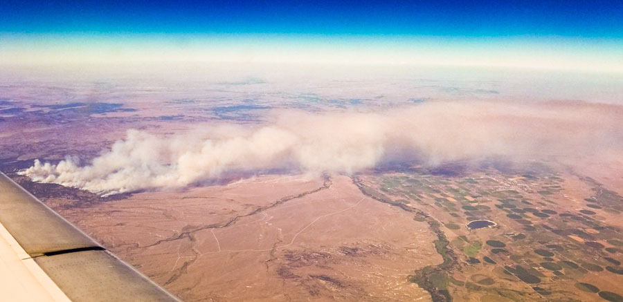
Photo by Nate Mezera @NateMez_turf as he flew over the Britania Mountain Fire August 29. Looking north. Wheatland, WY is under the smoke.


The Northern Rockies Fire Cache – A firefighting megastore

Above: Northern Rockies Fire Cache at Missoula. USFS photo.

(Originally published at 5:20 p.m. MDT August 29, 2018)

From adapters for everything imaginable to wrenches in all sizes – the Northern Rockies Fire Cache is a wildland firefighting megastore. When firefighters need equipment, tables, clothing, foot powder, sleeping bags, radios, or even medical supplies they call on the Cache to meet their needs.

Located in Missoula, Montana, the Northern Rockies Cache serves a wide range of federal, state, local and tribal government agencies within the Northern Rockies Geographical Area, an area of roughly 235,654 square miles.

The Northern Rockies Cache is capable of immediately supplying up to 5,000 firefighters and more than 30 major wildland fires. Support is sustained with a steady flow of replacement supplies from vendors and other Caches.

The Cache is moving toward becoming a minimal waste facility. Every piece of equipment returned to the Cache from a fire is assessed to see if it can be fixed, repaired, or refurbished. If it can, it is cleaned and repaired in-house saving considerable taxpayer dollars. If the equipment is beyond repair it gets recycled if possible. Last year alone the Cache recycled over 22,000 pounds of steel and almost 11,000 pounds of batteries.

Following the 2017 wildland fire season, the Cache inspected, laundered, and repaired over 40,000 pieces of Nomex clothing and over 9,000 sleeping bags. Working through this amount of laundry involves a lot of people – clothes and sleeping bags are inspected when they return from the fireline, sent to local businesses to be laundered, separated by size and condition, and those items needing a little TLC are set aside to be worked on during the winter months. Smokejumpers, known for their elite firefighting skills are also known for their sewing abilities and are called on during the winter to repair Nomex clothing so it can be used again the next season.

How does it work? When a fire burns for a number of days it quickly surpasses the local unit’s ability to provide needed supplies and provisions. Fire managers will place orders for the things they need to the Cache which quickly assembles and ships the supplies. When the fire no longer needs the supplies they return them to the Cache to be cleaned, refurbished and restocked. This includes the miles of hose that has to be pressure tested, cleaned to remove any aquatic hitchhikers (aquatic invasive species), dried, and finally rolled and stacked. Following the 2017 fire season over 1,200 miles of hose (enough hose to reach from Missoula to Long Beach, CA) went through this process.

fire cache at the National Interagency Fire Center
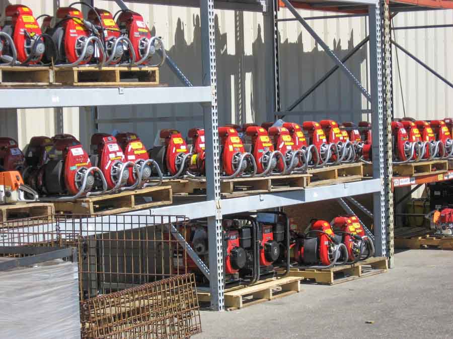
Portable pumps in the fire cache at the National Interagency Fire Center in Boise, ID. BLM photo.

A few Cache figures from the 2017 fire season: 1,300 pumps cleaned and refurbished (the last pump was put back on the shelf ready for the 2018 fire season in June – a year after the 2017 fire season began); almost 400 chainsaws, over 8,200 fire tools, almost 3 million pairs of earplugs, almost 300 pounds of foot powder, over 1.2 million AA batteries; and 64,420 MREs (meals ready to eat) which is enough to feed one person, three meals a day for 58.8 years.

Although its primary focus is to support fire suppression activities in northern Idaho, Montana, and North Dakota (referred to as the Northern Rockies Geographical Area), the Northern Rockies Cache may also lend support to any type of emergency incident in every part of the country. Beginning in the late 1990s, this helping hand and support was extended to include Canada, Mexico and Puerto Rico.

This Cache’s staffing operation consists of 15 people year round and up to 50 during the summer. This highly skilled workforce has met the needs of firefighters across the nation for the last 3 years with no serious accidents.

Utah firefighter adopts dog found at California wildfire

Many of us had not heard of Draper City, Utah before their fire department Battalion Chief Matthew Burchett was killed by a falling tree while fighting the Mendocino Complex of Fires in Northern California August 13, 2018. That was, of course, a tragedy, but now the city and department are in the news for a different reason. One of their firefighters found and has adopted a dog they found while fighting the same fire.

Firefighters meet at international border

The Horns Mountain / Santa Rosa Fire is burning in Washington and British Columbia

border canada united states firefighters horns mountain
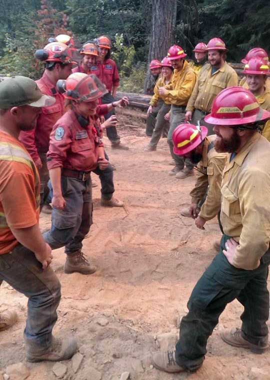
Firefighters meet at the Canada / United States border while working on the Horns Mountain Fire. Canadians on the left and Americans on the right. Photo by Johnny Walker.

(Originally published at 4:15 p.m PDT August 28, 2018)

The 5,500-acre Horns Mountain Fire is burning in both Canada and the United States — Washington and British Columbia — east of  the Laurier Port of Entry border crossing. In Canada the fire is named Santa Rosa.

In the photo above firefighters from both countries had a good natured meeting at the international border. I would wager that the topics discussed did not include tariffs or trade agreements.

Due to numerous large fires in Washington and British Columbia, both sides experienced a shortage of resources. According to an update from the incident management team, “working together was a benefit to both”.

The fire is winding down thanks in part to favorable weather in the last few days. Some resources on both sides are being demobilized.

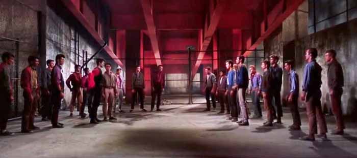
UPDATE: August 29, 2018: When we posted this on our Facebook page Eric Haberin wrote, “Very much West Side Story”. I found the fight scene on YouTube and got a screenshot:

fight scene in West Side Story
The Jets face off with the Sharks in West Side Story.

The big difference is that the firefighters are smiling.

Britania Mountain Fire burns USFS and private land west of Wheatland, WY

(UPDATED at 3:06 p.m. MDT August 29, 2018)

(To see all of the articles on Wildfire Today about the Britania Mountain Fire, including the most recent, click HERE.)

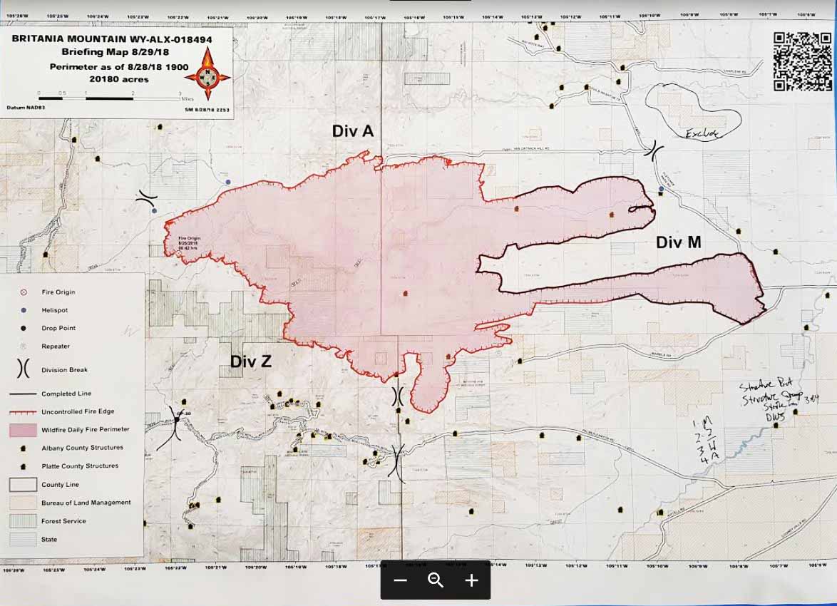
The incident management team on the Britania Mountain Fire 8 miles northeast of Wheatland, Wyoming has released a map of the fire:

Map Britania Mountain Fire
Map of the Britania Mountain Fire by the Incident Management Team; data from 7 p.m. MDT August 28, 2018. Click to enlarge.

Mandatory evacuations have been issued for Palmer canyon. The Red Cross set up an evacuation center in Wheatland at the Services for Seniors Annex, 809 16th St. They are asking those evacuating to call (307) 322-3279.


(UPDATED at 11:04 a.m. MDT August 29, 2018)

The Britania Mountain Fire 8 miles northwest of Wheatland, Wyoming has burned at least 20,180 acres and 16 structures according to information released by fire officials Wednesday morning. It is not clear how many of the structures are outbuildings or residences, or how current the data is. Very little official information has been released about the fire since it started on August 26.

On Tuesday the Britania Mountain Fire spread to the south into even more rugged terrain.

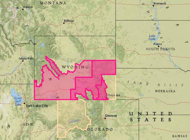
The area is under a Red Flag Warning through Thursday. The forecast calls for southwest winds of 15 to 25 with gusts to 35 mph and relative humidity of 10 to 15 percent in the afternoons on both days. This could spread the fire farther to the east and northeast if receptive fuels are available.

Red Flag Warnings, August 29, 2018
Red Flag Warnings, August 29, 2018.

A Type 2 Incident Management Team with Incident Commander Shane Greer was scheduled to in-brief Wednesday morning at 8 a.m. Tuesday evening 259 personnel were assigned.

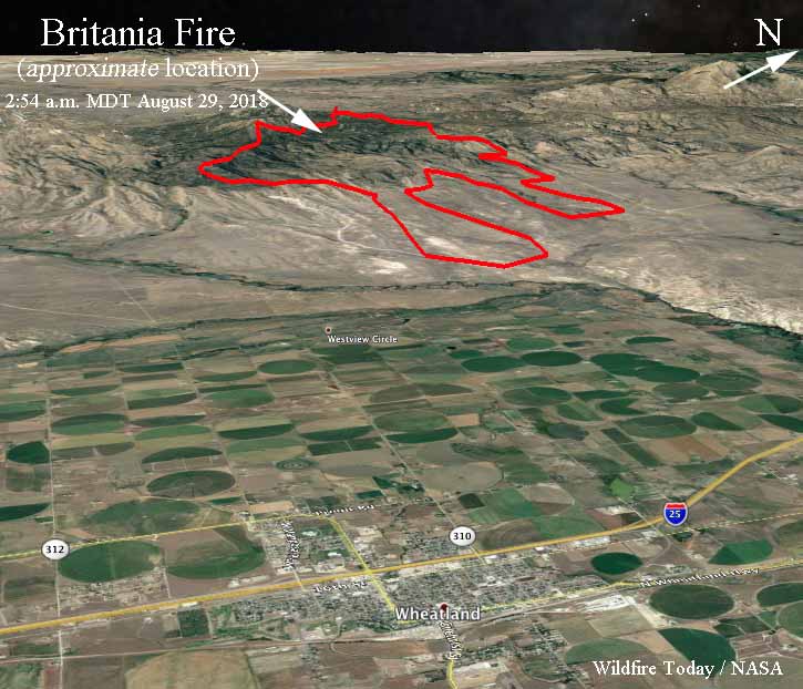
The maps below show the APPROXIMATE location of the Britania Mountain Fire. It is based on heat sensing data from a satellite at 2:54 a.m. MDT August 29 and a map created by fire personnel that used data from 7:46 p.m. August 27.

map Britania Fire Wyoming
The shows the APPROXIMATE location of the Britania Mountain Fire. It is based on heat sensing data from a satellite at 2:54 a.m. MDT August 29 and a map created by fire personnel with data from 7:46 p.m. August 27.

During the satellite overflight at 2:54 a.m. MDT Wednesday the only large heat sources detected were on the southern-most perimeter and the southwest side. At about 200 miles above the Earth smaller heat sources scattered across the fire can’t be “seen” by the sensors. On the map above the heat stretched across the south edge for 4 miles west of the County line (the green line) and one mile to the east. The fire spread further to the south in this area.

3-d map Britania Mountain Fire
The 3-D map shows the APPROXIMATE location, looking west-northwest, of the Britania Mountain Fire. It is based on heat sensing data from a satellite at 2:54 a.m. MDT August 29 and a map created by fire personnel with data from 7:46 p.m. August 27.

(Originally published at 11:30 a.m. MDT August 28, 2018)

The Britania Fire west of Wheatland, Wyoming has grown to approximately 18,800 acres. Shifting winds and rugged terrain are creating challenges for the 150 to 200 firefighters on scene, including one crew from Florida. More resources will be arriving today (Tuesday). The fire is approximately 8 to 12 miles west of Wheatland, Wyoming and 68 miles north of Cheyenne.

Continue reading “Britania Mountain Fire burns USFS and private land west of Wheatland, WY”