Report issued on one of the devastating fires near Athens, Greece

Greece wildfire July 2018

A report has been issued about one of the wildfires that recently burned into populated areas in Greece (covered by Wildfire Today here). The National and Kapodistrian University of Athens distributed the document in their Newsletter of Environmental, Disaster, and Crisis Management Strategies.

The fire started July 23, 2018 near the community of Kallitehnoupolis on Penteli Mountain, approximately 20km (12 miles) northeast of Athens and 5.6 km (3.5 miles) west of the Aegean Sea. With the extreme weather conditions it spread quickly east to Kallitechnoulopis, Neos Voutzas, Rafina, and reached Mati where it finally stopped at the coast.

The Fire Service responded, sending 60 personnel in  24 vehicles, 2 ground forces teams, 3 Canadair scooping air tankers, and a helicopter.

Pushed by strong winds out of the west the fire ran 5.6 km (3.5 miles) in about 90 minutes, moving through a densely populated area frequented by tourists.

From the report:

The aftermath is tragic. The fire burned approximately 1,276 ha (3,153 acres), estimated from satellite data. Within the area, there are approximately 1,220 totally destroyed buildings (according to official inspections) and 305 burned vehicles. The days following the event, the authorities recovered at least 91 bodies from the scene (updated July 31, 2018 at 11.00am). Several missing persons were reported and tens of injured (approximately 200 at some point) were transferred to nearby hospitals.

The wind speeds recorded by a network of weather stations were the highest seen during the summer months in the last eight years, with gusts of 100 to 120 km/hour (62 to 74 mph).

The rapid spread of the fire and with little effective notification, the residents and tourists in the communities in its path and the densely populated city of Mati had little chance to escape. The report said, “The population had almost zero time between risk awareness and reaction decision”.

Greece wildfire July 2018Many got in their vehicles and drove away from the blaze toward the coast. They encountered urban planning, or the lack of it, that included narrow streets, numerous dead ends, elongated blocks without the possibility of lateral escape, and the absence of areas that could serve as safety zones. The visiting tourists who were often not very familiar with the layout of the streets were at a particular disadvantage. The low visibility due to the smoke was another challenge. Continue reading “Report issued on one of the devastating fires near Athens, Greece”


North part of Mendocino Complex of Fires was very active Wednesday

Late in the day the Ranch Fire ran for at least five miles to the southeast

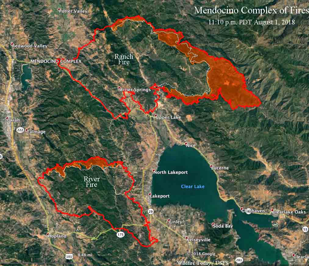
The northernmost of the two fires in the Mendocino Complex east of Ukiah, California, the Ranch Fire, was very active late in the day on Wednesday, running for at least five miles to the southeast according to the very reliable information from a mapping aircraft at 11:10 p.m. August 1. It is possible it may have spread for an additional three miles three to five hours later, but the data from the later overflights by the MODIS and VIIRS satellites could have been detecting heat and debris in a powerful convection column, rather than fire on the ground. All of the significant activity on the Ranch Fire Wednesday was on the northeast and east sides.

map Mendocino Complex River Fire Ranch fire
Map showing the perimeter, in red, of the Mendocino Complex of Fires at 11:10 p.m. MDT, August 1, 2018. The white line was the perimeter about 24 hours before. The red shaded areas represent intense heat. Click to enlarge.

With the expansion of the Ranch Fire it is now about three to five miles northeast of the community of Nice and four to seven miles northeast of Lucerne; both of these communities are on the east shore of Clear Lake.

To see all of the articles on Wildfire Today about the Mendocino Complex of Fires, including the most recent, click HERE.

Apparently firefighters on the River Fire have been very successful on the south and east flanks, with those locations showing little to no growth Wednesday in the Lakeport and Finley areas. The north side, however, was quite active, spreading north for about a half mile across the north perimeter.

CAL FIRE reports that 14 residences have been destroyed. The two fires have burned a total of 110,168 acres — 74,890 on the Ranch Fire and 35,278 on the River Fire, according to the numbers released by CAL FIRE Thursday morning.

Wildfire potential for August through November

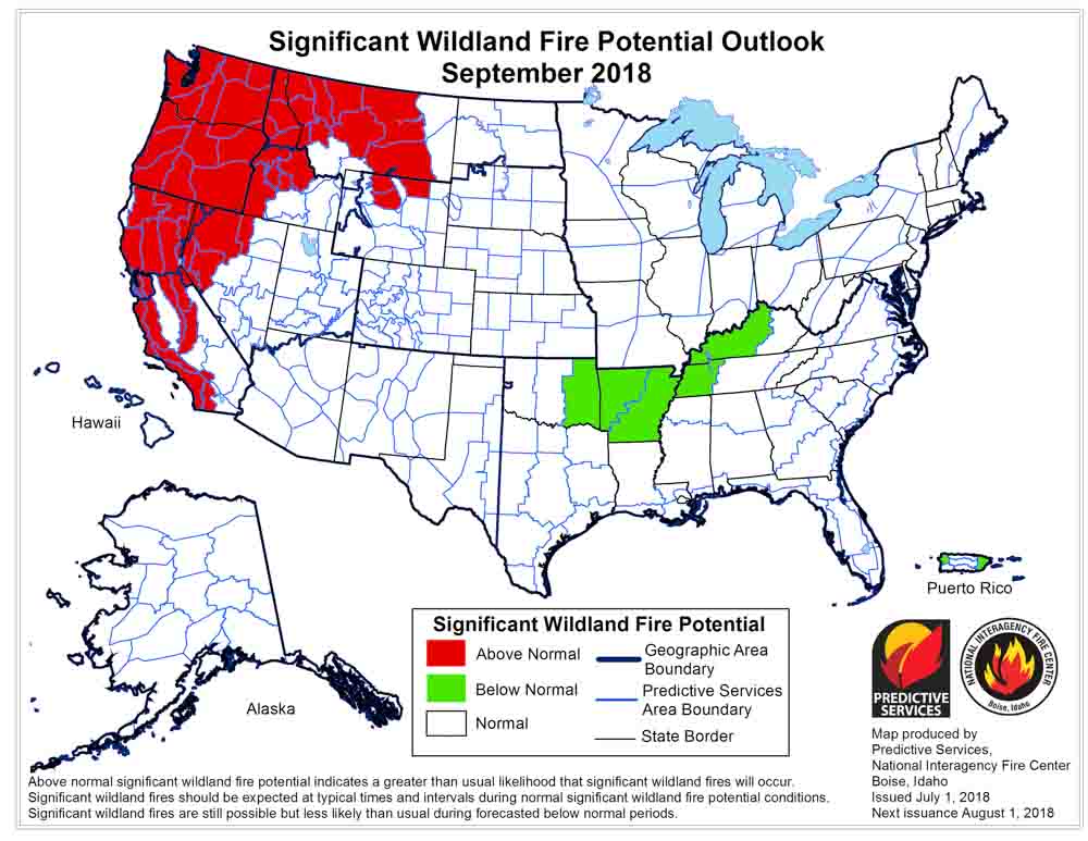
Above: Wildfire potential for August, 2018. NIFC.

(Originally published at 1:20 p.m. MDT August 1, 2018)

On August 1 the Predictive Services section at the National Interagency Fire Center issued their Wildland Fire Potential Outlook for August through November. The data represents the cumulative forecasts of the ten Geographic Area Predictive Services Units and the National Predictive Services Unit.

If their analysis is correct, in August and September firefighters will be busy in Washington, Oregon, Idaho, California, and northern Nevada.

Below are:

  • An excerpt from the NIFC narrative report for the next several months;
  • NIFC’s monthly graphical outlooks;
  • NOAA’s three-month temperature and precipitation forecasts; and,
  • Drought Monitor.

“August is the peak month for fire activity across the West. Given the amount of lightning received along with preexisting heavy fuel loading and dryness, a very active month is expected with Above Normal significant wildland fire potential likely across portions of the Pacific Northwest, Northern Rockies, northern Great Basin, and California. Typically, a weather event occurs by mid-September that brings moisture to regions experiencing significant fire activity which allows for the western fire season to begin to decrease in activity. Given ongoing trends that support a normal seasonal progression and given a transition from ENSO Neutral conditions to El Niño, such an event is expected. Most regions will exit the fire season at this point, but only a brief lull is expected across California before it enters its fall fire season by October and November. Given ongoing dryness in the fuels, the fall season may very well be robust across portions of the state.”

September 2018 wildfire potential

Continue reading “Wildfire potential for August through November”

Mendocino Complex of Fires spreads closer to Lakeport

There are media reports that homes were destroyed Tuesday afternoon northwest of Lakeport

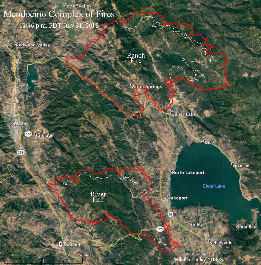
ABOVE: Map showing the perimeter, in red, of the east side of the River Fire (part of the Mendocino Complex of Fires) at 11:46 p.m. PDT July 31, 2018. The white line was the perimeter about 24 hours before.

(Originally published at 10 a.m. PDT August 1, 2018)

Tuesday afternoon winds pushed the two blazes that comprise the Mendocino Complex of Fires farther east, both spreading for at least a mile. The Ranch Fire moved into sparsely populated areas, but the River Fire ran through an area with scattered ranches northwest of Lakeport, California. Media personnel on scene said the fire was especially intense near Dessie Drive and Hendricks Road. CAL FIRE said Wednesday morning that a total of 10 residences have been destroyed in the two fires, but it is not clear if that number includes what could be additional losses late in the day on Tuesday.

To see all of the articles on Wildfire Today about the Mendocino Complex of Fires, including the most recent, click HERE.

Firefighters were extremely busy Tuesday in that wildland-urban interface as the fire raced through the populated areas. They were protecting structures, then getting chased out by flames, and reestablishing a defense at another structure.

Mendocino Complex fires map
Map showing the perimeter, in red, of the Mendocino Complex of Fires at 11:46 p.m. PDT July 31, 2018. The white line was the perimeter about 24 hours before.

Both fires started in Mendocino County but burned into Lake County. The Ranch Fire is now also well established in the Mendocino National Forest.

According to the numbers CAL FIRE released Wednesday morning, the two fires have burned 90,912 acres; 59,019 on the Ranch Fire, and 31,898 on the River Fire.

As usual, Kent Porter got some fabulous shots of the River Fire Tuesday:

Below, a CAL FIRE Battalion Chief explains how they fight fires when you don’t have enough resources. Basically, you protect lives and private property first, then as time and resources permit, deal with the part of the fire that is burning in remote areas.

Wildfire activity increases in Colorado

Fires western Colorado
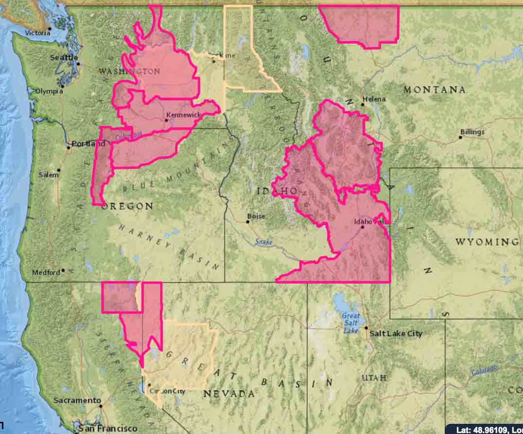
Fires in western Colorado, July 31, 2018.

After having received some monsoonal moisture, Western Colorado apparently is drying a bit, and has quite a few active fires.

Below is information provided by the Rocky Mountain Coordination Center July 31, 2018. Some of the larger ones that are active are listed below, north to south.

Cabin Lake: 350 acres, 103 personnel. White River N.F. ICT3 (Thompson) 16 miles SE of Meeker, CO. Fuel model 4 and 10. Extreme fire behavior with crowning, wind-driven runs and spotting. Residential structures and powerlines threatened. Road, trail and area closures in effect.

Red Canyon: 1,500 acres; 136 personnel. White River BLM. ICT4 (Jacob) 45 miles SW of Meeker, CO. Fuel model 5 and 2. Moderate fire behavior with running, uphill runs and spotting. Residential structures, oil and gas infrastructure and FAA Tower threatened. SWA IMT (Andrews) transition of command anticipated 2400 7/30.

Cache Creek: 325 acres; 50 personnel. White River N.F. ICT3 (Spetter/Ottoson(T)) 8 miles SW of Rifle, CO. Fuel model 10. Moderate fire behavior with single tree torching, group torching and long-range spotting. Oil and gas infrastructure, watershed and private timber interests threatened. RMA IMT2 (Esperance) in-brief 2000 7/30.

Lake Christine: has been burning since July 3, 2018. 12,588 acres, 313 personnel. Eagle County. RMA IMT2 (Greer). One mile NW of Basalt, CO. Fuel model 8 and 2. Minimal fire behavior with smoldering and creeping. Threat to residential structures, private inholdings and high voltage transmission lines, communications infrastructure, water supply infrastructure, commercial airline corridor. Road, area and trail closures in effect. Transfer of command to local IMT3 (Anderson) planned for 7/31. Expected containment 8/2.

Buttermilk:  671 acres, (no more information)

Plateau: 1,200 acres, 87 personnel. San Juan N.F. ICT3 (Seekins/Stark (T)). 13 miles N of Dolores, CO. Fuel model 10 and 2. Moderate fire behavior with short range spotting, isolated torching, group torching and wind driven runs. Road and area closures in effect.