Spring Creek Fire spreads closer to highway 12

(UPDATED at 8 p.m. MDT July 2, 2018)
Map Spring Creek Fire
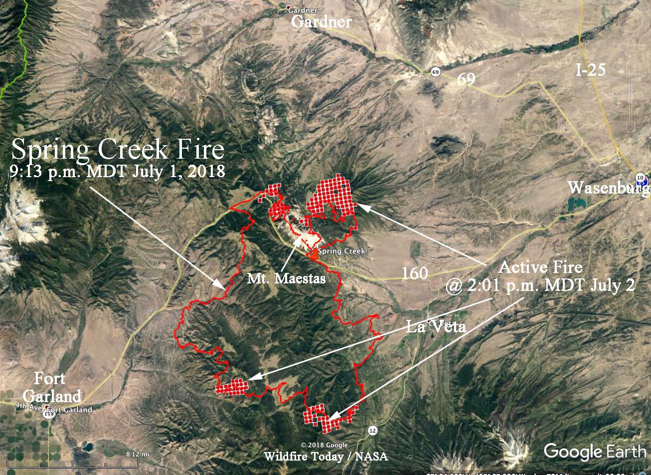
The Spring Creek Fire showing updates from 9:13 p.m. MDT June 1, and from 2:01 p.m. MDT July 2, 2018. Click to enlarge.

A brief update on the Spring Creek Fire burning 17 miles west of Walsenburg, Colorado. Monday afternoon at 2:01 a satellite detected active fire on the north side of Mt. Maestas. At that time the fire had not made it down to the flatter terrain on the north side but it may have by sundown. There was also activity on the southeast side during the satellite overflight.

Portions of several highways are closed, including 69, 160, and 12.
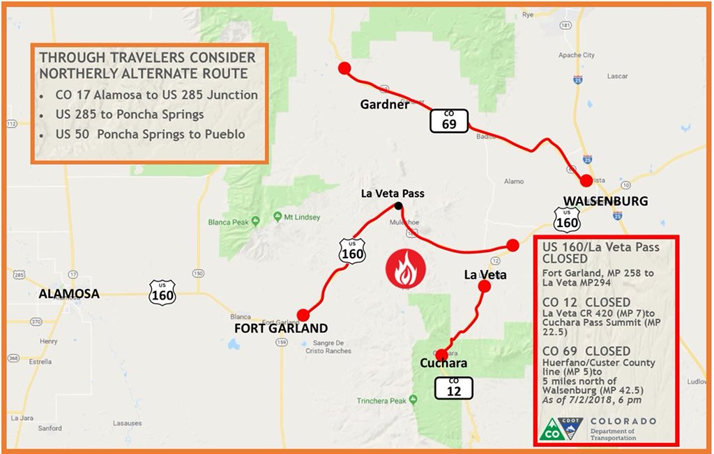
Closed Roads
Closed Roads. July 2, 2018. Colorado DOT.

(Updated at 12:27 p.m. MDT July 2, 2018)

On Sunday and Sunday night the Spring Creek Fire east of Fort Garland, Colorado spread closer to Highway 12, coming to within two miles in some places.

According to the Incident Management Team the fire has burned 56,820 acres with most of that being on private land. Approximately 2,878 structures are threatened but so far none have been destroyed.

Tuesday morning the management of the fire will be spilt with two Rocky Mountain Type 2 IMTs. The Blue Team will take the portion of the fire north of Highway 160.

CLICK HERE to see all of the articles on Wildfire Today about the Spring Creek Fire.

The IMT is concerned about outflow winds from passing thunderstorms Monday which could push the fire in any direction. The fire should become active before noon, and could be very active throughout the afternoon.

On the east side of the fire, growth has slowed somewhat as the fire moves into lighter fuels. Indirect contingency lines are being constructed, anchoring to the 421 road and Highway 12, with the goal of keeping the fire west of La Veta.

Below is more information from the IMT:

“On the south side in Division K, the fire has moved south of East Indian Creek and is progressing over the ridges of Raspberry Mountain, continuing downslope through heavy fuels. While this type of “backing” behavior (downhill growth), does not move as quickly as fire running up hill, the fire is expected to continue moving south/southwest toward Cuchara Village. The geography between Raspberry Mountain and the communities of Pinehaven and Cuchara Village is extremely challenging with significant beetle kill fuel, rough terrain and narrow canyons. This is a difficult area to place firefighters, as there are minimal escape routes should fire intensity change. As fire continues to push south, crews are constructing indirect line around the communities of Pinehaven and Cuchara Village and will prepare structures in this area in the event of fire spread. Expect to see large smoke columns in this area today.

“The fire is growing to the south-southwest in Divisions N and Z, pushing toward West Indian Creek. Crews are successfully implementing point protection for houses in the South Forbes community. Firefighters are scouting for opportunities to create indirect line to keep the fire north of West Indian Creek. On the southeast side of the fire, crews are working to construct fireline off Mallott Rd, moving from Division A south and east into Divisions Z and N to keep fire east of Trinchera.

“The west and northwest sides of the fire in Divisions A and D continue to hold. The 5% containment is along the northwest perimeter in Division D. Crews are scouting for options for more indirect line running from the ridges back into Highway 160.

“There is now a portable fire retardant plant east of La Veta. Aircraft will drop retardant on areas where its effects will be successful. Air tankers are in use, and the Spring Fire now has two National Guard Blackhawk helicopters participating in air operations along with currently assigned resources.”

County Fire roars through the hills above Lake Berryessa

The fire is burning northeast of the San Francisco Bay area 19 miles northeast of Napa and 28 miles west of Sacramento.

(Originally published at 6:12 a.m. PDT July 2, 2018)

Burning in both Yolo and Napa Counties, the County Fire has doubled in size in the last 24 hours. The blaze is running across Rocky Ridge east of Lake Berryessa northeast of the San Francisco Bay area.

(Click Here to see all of the articles on Wildfire Today about the County Fire, including the most recent.)

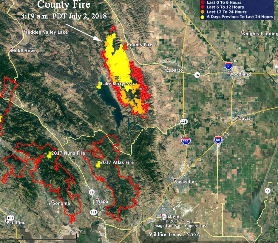
Our VERY UNOFFICIAL estimate based on satellite data indicates that at 3 a.m. Monday it had burned approximately 42,000 acres — roughly 1,100 acres an hour since it was reported at 2:12 p.m. June 30. CAL FIRE’s official estimate released at 7:49 p.m. Sunday put it at 32,500 acres. During the 3 a.m. overflight there were large areas of very active fire, as represented by the red dots in the map below.

County Fire map Atlas fire
Map showing heat detected on the County Fire by a satellite at 3:03 a.m. PDT July 2, 2018. The footprints of fires that devastated large areas in October 2017 are also shown: the Atlas, Nuns, and Tubbs Fires. Click to enlarge.

The County Fire is spreading northeast of the areas devastated by the North Bay Area Fires of October, 2017 that destroyed over 7,000 structures and killed 31 people. The footprint of the Atlas Fire could serve as a partial barrier, reducing the chance that this new fire could reach the Napa area again. But if it keeps moving south and crosses Highway 128 into Solano County there are many homes that could be threatened in the Vacaville area.

Many areas are under mandatory evacuation orders. For questions regarding Yolo County evacuations or advisories, dial 2-1-1. For questions regarding Solano County evacuations or advisories dial (707) 398-8261.

Evacuation center: Guinda Grange Hall in the Community of Guinda 16487 Forest Ave. Guinda, CA 95637.

The fire is being battled by 1,226 personnel, including 119 fire engines, 27 hand crews, 12 helicopters, 23 dozers, and 34 water tenders.

County Fire burns tens of thousands of acres north of Napa, Calif.

map county fire california
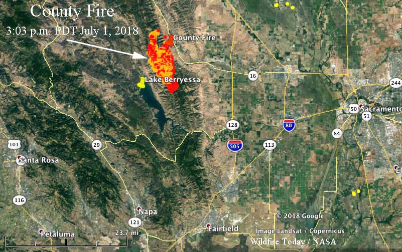
Map showing heat detected by a satellite on the County Fire at 3:03 p.m. PDT July 1, 2018.

In a little more than 24 hours after starting, the County Fire has burned approximately 22,000 acres in northern California 18 miles north of Napa. Mandatory evacuations are taking place in several areas.

(Click Here to see all of the articles on Wildfire Today about the County Fire, including the most recent.)

It started near the line that separates Napa and Yolo Counties, and since then about two-thirds of the fire has spread into Yolo County south of Guinda and west of Highway 16, covering an area 17 miles long parallel to the county line.

The weather forecast for Monday morning predicts fairly strong winds generally out of the north and northeast at 12 to 21 mph gusting up to 31, but the relative humidity will be above 50 percent until 11 a.m. and then will drop into the 20s by late afternoon.

Weston Pass & Chateau Fires burn thousands of acres west of Colorado Springs

Above:  Map showing the locations of the Chateau and Weston Pass Fires, with data from about 11 p.m. MDT June 30, 2018.

(Originally published at 7:20 am MDT July 1, 2018)

The Chateau Fire is burning 24  miles west of Colorado Springs 7 miles northwest of Cripple Creek. Since it was reported June 29 it has been managed by Lohmire’s Type 4 Incident Management Team and has blackened 1,425 acres according to Sunday’s National Situation Report.

Another fire in that part of Colorado, the Weston Pass Fire, was reported June 28 and had burned an estimated 4,138 acres by 11 p.m. Saturday, which was the best guess after a mapping flight that was partially obscured by clouds. It is 64 miles WNW of Colorado Springs and 16 miles southeast of Leadville. Musser’s Type 3 Incident Management Team has been handling this fire.

Weston Pass Fire
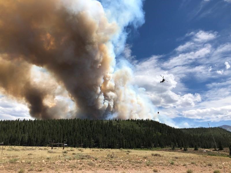
A helicopter works the Weston Pass Fire. Undated & uncredited photo uploaded to Inciweb June 30, 2018.

Todd Pechota’s Type 1 Team mobilized Saturday and will eventually be assuming command of both incidents.

Both fires are highly visible and have structures nearby, which may explain dispatching a Type 1, rather than a Type 2 Team. But we have also noticed a recent trend in Colorado to attack fires more aggressively than in the recent past. Crews and aircraft have been responding earlier and in greater numbers than in previous years. This is a welcome development.

Multiple wildfires burning in Colorado

Above: Colorado Fires. Heat detected at 1:01 p.m. MDT June 30, 2018.

(UPDATED at 6:11 p.m. MDT June 30, 2018)

Colorado has been the location where much of the firefighting action has taken place during the last couple of weeks and that continues as at least five large blazes burn across the state.

The map above shows the locations of the largest and most active fires. The heat data on the map is from 1:01 p.m.  MDT June 30.

Here is the list:

  • 416 Fire, 9 miles north of Durango. 47,000 acres. It started June 1.
  • Spring Creek Fire, between La Veta and Fort Garland along Highway 160. 38,000 acres. CDOT reports that the closure of US 160 between Fort Garland and La Veta and the closure of CO 12 between Cuchara and La Veta, will continue. The fire is now pretty well established on the north sides of Highway 160 and Mt. Maestas. (More information.)
  • Chateau Fire, 7 miles northwest of Cripple Creek. Our VERY UNOFFICIAL estimate puts it at 1,300 acres early Saturday afternoon. (More information)
  • Weston Pass Fire, 16 miles southeast of Leadville. Our VERY UNOFFICIAL estimate puts it at 3,400 acres early Saturday afternoon. US 285, in Park County, is closed between Fairplay and Antero Junction (mp 188 to mp 163) in both directions. A Type 1 Incident Management Team has been ordered and will assume command  7/1. This team will manage both the Weston Pass Fire and the High Chateau Fire. (More information)
  • Sugarloaf Fire, 13 miles northeast of Silverthorne. The Forest Service estimates it has burned about 1,300 acres. This fire is not being fully suppressed.

Granite Mountain Hotshots — five years ago today

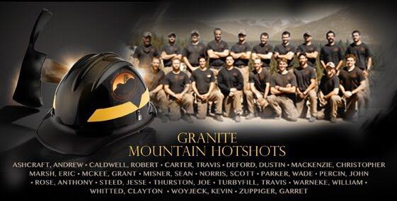
Granite Mountain HotshotsWhen I think about the June 30, 2013 tragedy where 19 firefighters were killed battling a fire near Yarnell, Arizona, I remember Abraham Lincoln’s Address as he and others dedicated a military cemetery in Gettysburg, Pennsylvania, where thousands of soldiers died almost exactly 155 years ago, July 1-3, 1863, in what has been described as the turning point of the Civil War. We don’t even know for sure the number killed, with estimates ranging from 7,000 to 8,000.

The President was honoring those who were killed in the battle. The men fought each other, the North vs. the South. Wildland firefighters, thankfully, don’t fight each other, but there are similarities between fighting wars and fighting wildfires.

That day in 1863 the President said in part:

“…It is rather for us to be here dedicated to the great task remaining before us—that from these honored dead we take increased devotion to that cause for which they gave the last full measure of devotion—that we here highly resolve that these dead shall not have died in vain.”

It is difficult to find positive outcomes in a mass casualty incident like the Yarnell Hill Fire. But one thing that is doable, is to at least learn some lessons, and more importantly, use them to take action to reduce the number of fatalities on wildland fires. We will never eliminate all risks of firefighting, but proactive management locally, at the national level within the agencies, and in Congress, can make a difference.

Excerpt from Lincoln’s Gettysburg Address:


“…Now we are engaged in a great civil war, testing whether that nation, or any nation so conceived and so dedicated, can long endure. We are met on a great battle-field of that war. We have come to dedicate a portion of that field, as a final resting place for those who here gave their lives that that nation might live. It is altogether fitting and proper that we should do this.

“But, in a larger sense, we can not dedicate—we can not consecrate—we can not hallow—this ground. The brave men, living and dead, who struggled here, have consecrated it, far above our poor power to add or detract. The world will little note, nor long remember what we say here, but it can never forget what they did here. It is for us the living, rather, to be dedicated here to the unfinished work which they who fought here have thus far so nobly advanced. It is rather for us to be here dedicated to the great task remaining before us—that from these honored dead we take increased devotion to that cause for which they gave the last full measure of devotion—that we here highly resolve that these dead shall not have died in vain—that this nation, under God, shall have a new birth of freedom—and that government of the people, by the people, for the people, shall not perish from the earth.”