Rapidly spreading fire west of Gatlinburg, TN

map East Miller Cove Fire
Map showing the location of the East Miller Cove Fire at 10:30 p.m. ET November 18, 2016.

The East Miller Cove Fire 16 air miles west of Gatlinburg, Tennessee spread very rapidly Friday night as a cold front passed through with winds shifting from south to west gusted at 12 to 23 MPH. However the nearby Indian Grave weather station in Great Smoky Mountains National Park recorded 0.12 inches of rain after 6 a.m. on Saturday.

When a mapping aircraft overflew the fire at 10:30 p.m. Friday the fire had burned 700 acres and was very active. Data from a heat sensing satellite at 3:04 a.m. Saturday indicated that it was more than 1,000 acres.

The East Miller Cove Fire is just east of Walland, Tennessee, five miles north of Great Smoky Mountains National Park, and 16 air miles south of Knoxville.

On Friday hundreds of students at the Walland elementary school were ordered to evacuate.

At least one Blackhawk helicopter from the Tennessee National Guard assisted firefighters on the ground by dropping water.

The area is under a Red Flag Warning on Saturday for strong winds and low humidities. The forecast calls for temperatures on Saturday in the high 40s, 45 percent relative humidity, 60 percent cloud cover, 15 mph west to northwest winds gusting at 23 mph, and the probability of rain decreasing to 4 percent by 1 p.m. Sunday should be cooler, drier, and with 8 mph winds out of the northwest.

Many locations in the South have had very little rain over the last two months, leaving the live and dead vegetation very dry. Below is an excerpt from a Saturday morning article at Knoxnews:

…Nothing in the weekend weather looks as if it will be much help to firefighters, according to regional safety officer James Gregory, who is also up from Florida to help fight the Tennessee wildfires. He is a Maryville native who knows east Tennessee parks and wilderness well.

“The ground cover, the layer of twigs and branches and grass and vegetation that normally helps keep trees upright during a fire, is so dry and brittle, it can’t hold the trees in place so they fall over,” Gregory explained. “When a burning tree falls over, of course that spreads the flames. Even live trees that aren’t on fire fall over because the drought has dried out the forest so much.”

The article also said the rain “had almost no impact” on the fires in east Tennessee.

Southern states under a Red Flag Warning, November 19, 2016

Eight states expected to have enhanced wildfire danger.

The National Weather Service has posted Red Flag Warnings or Fire Weather Watches for areas in Mississippi, Alabama, Georgia, Tennessee, North Carolina, South Carolina, Florida and California.

Following the passage of a cold front in the southeast the relative humidity is expected to fall into the upper 20s to the low 40s, along with increasing northwesterly winds gusting at 25 to 42 mph.

The map was current as of 8:15 a.m. MT on Saturday. Red Flag Warnings can change throughout the day as the National Weather Service offices around the country update and revise their forecasts and maps.

Firefighter killed after being struck by tree limb

Rodney Collett
Photo courtesy of Red Bird VF&R

We regret to pass along the news that a firefighter in Kentucky has been killed while fighting a wildland fire. Rodney Collett served on two departments, the Bell County Volunteer Fire Department in Pineville, Kentucky and the Redbird Volunteer Fire and Rescue Department in Manchester, Kentucky.

On October 29th Firefighter Collett was working with Red Bird VF&R on a wildfire in Clay County when a tree limb fell striking the fire apparatus and Firefighter Collett causing him to suffer head and arm injuries. He was airlifted to Pikeville Medical Center for treatment. Tragically, Firefighter Collett succumbed to his injuries Thursday evening, November 17.

Firefighter Collett was 44 years and is survived by his parents — Ted and Shirley, and his sister — Connie. Funeral arrangements are pending and will be posted on SupportingHeroes.org.

Between 1990 and 2014 18 firefighters were killed by hazardous trees.

Our sincere condolences go out to Firefighter Collett’s family, friends, and co-workers.

Thanks and a tip of the hat go out to Chris.

Precipitation reduces wildfire smoke in the central U.S.

Above: Snow cover in the United States, November 18, 2016. The Weather Channel.

Precipitation in the northwest quarter of the United States this week has put even more of a damper on the occurrence of wildfires, the execution of prescribed fires, and agricultural burning.

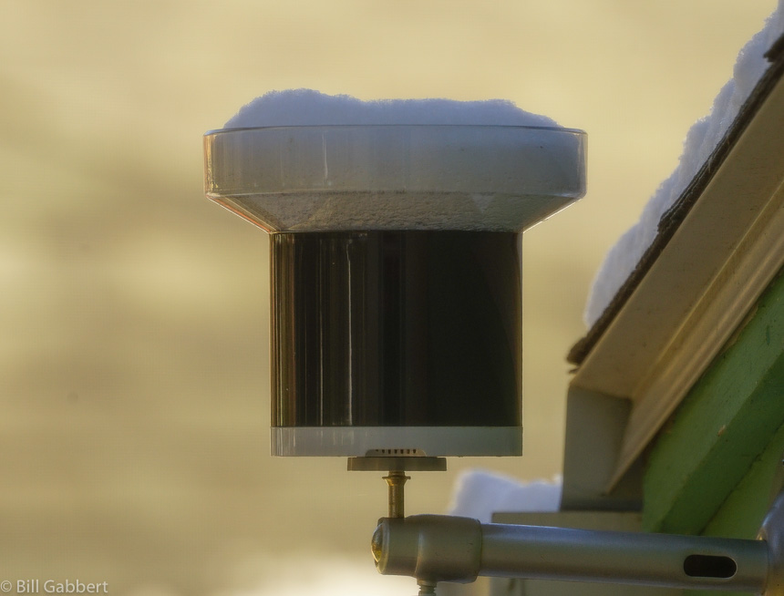
After weeks of warm, dry weather the Black Hills finally received a little precipitation over the last 24 hours. I won’t know the exact amount at my house until the snow in the rain gauge melts, but there was an inch or two of the white stuff on the ground. Today is sunny with a high of 32 predicted, so maybe it will trickle through the tipping bucket this afternoon.

snow rain gauge
Snow captured by my rain gauge since Thursday afternoon. Photo at 11 a.m. MT November 18, 2016 by Bill Gabbert.

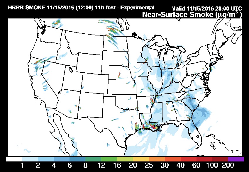
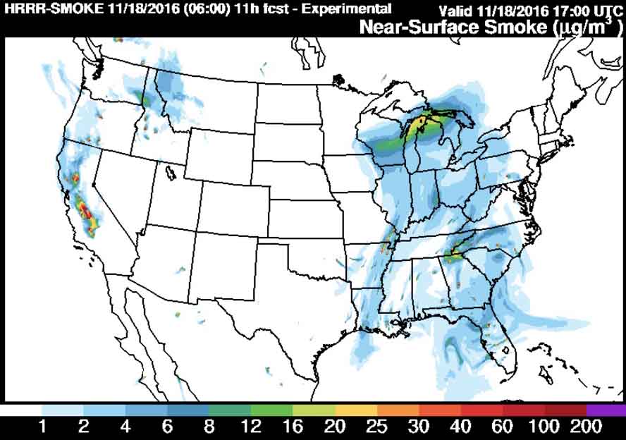
Small amounts of precipitation in southern Saskatchewan may be the reason smoke from that area is no longer immigrating into the United States, as you can see in the two maps below. The first one was the smoke forecast for November 15 and the one after that is for today, November 18.

wildfire smoke forecast
Prediction for the distribution of smoke from wildfires at 6 p.m. ET, November 15, 2016. Produced at 7 a.m. ET November 15.
wildfire smoke forecast
Forecast for wildfire smoke at 6 p.m. ET November 18, 2016, created at 1 a.m. ET November 18, 2016.

However, prescribed fires, wildfires, or agricultural burning in Louisiana, Arkansas, and eastern Texas are still producing large quantities of smoke that at times moves north into the midwest.

No rain is predicted until the middle of next week for the areas where wildfires are smoking out the residents in some areas of Tennessee, North Carolina, Georgia, and South Carolina.

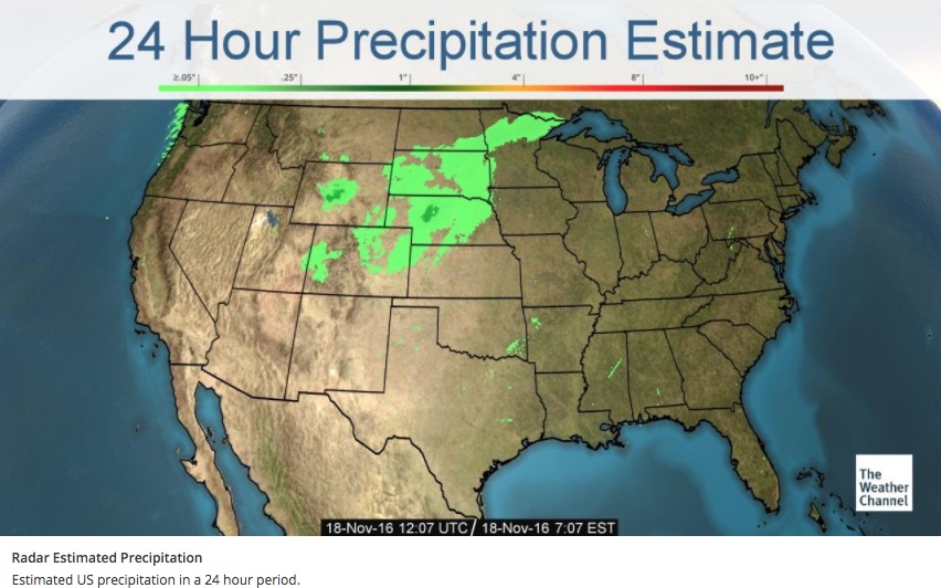
24 hour precipitation
Accumulated precipitation estimated by radar over the 24 hours before 7:07 a.m. ET November 18, 2016.


North Carolina to receive the worst of the smoke on Friday

Above: Forecast for wildfire smoke at 6 p.m. ET November 18, 2016. Created at 1 a.m. ET November 18, 2016.

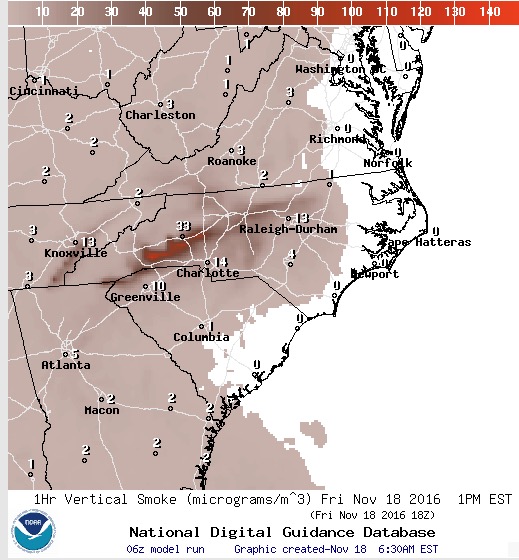
Most of the eastern one-third of the United States will be experiencing some degree of wildfire smoke on Friday. But by far the heaviest concentrations are being created by the wildfires in the South. The winds on Friday will cause the much of the smoke to pass through areas in western Tennessee, northern Georgia, and western North Carolina.

Forecast for wildfire smoke at 1 p.m. ET November 18, 2016, created at 6:30 a.m. ET November 18, 2016.

Continue reading “North Carolina to receive the worst of the smoke on Friday”

Research: Wildfires in Sierra Nevada driven by past land use

Changes in human uses of the land have had a large impact on fire activity in California’s Sierra Nevada since 1600, according to research by a University of Arizona researcher and her colleagues.

Above: Indian Canyon Fire near Edgemont, SD, 2016. Photo by Bill Gabbert.

By Mari N. Jensen, University of Arizona College of Science

Forest fire activity in California’s Sierra Nevada since 1600 has been influenced more by how humans used the land than by climate, according to new research led by University of Arizona and Penn State scientists.

For the years 1600 to 2015, the team found four periods, each lasting at least 55 years, where the frequency and extent of forest fires clearly differed from the time period before or after.

However, the shifts from one fire regime to another did not correspond to changes in temperature or moisture or other climate patterns until temperatures started rising in the 1980s.

“We were expecting to find climatic drivers,” said lead co-author Valerie Trouet, a UA associate professor of dendrochronology. “We didn’t find them.”

Instead, the team found the fire regimes corresponded to different types of human occupation and use of the land: the pre-settlement period to the Spanish colonial period; the colonial period to the California Gold Rush; the Gold Rush to the Smokey Bear/fire suppression period; and the Smokey Bear/fire suppression era to present.

“The fire regime shifts we see are linked to the land-use changes that took place at the same time,” Trouet said.

“We knew about the Smokey Bear effect — there had been a dramatic shift in the fire regime all over the Western U.S. with fire suppression. We didn’t know about these other earlier regimes,” she said. “It turns out humans — through land-use change — have been influencing and modulating fire for much longer than we anticipated.”

Continue reading “Research: Wildfires in Sierra Nevada driven by past land use”