USFS bans exploding targets in their Northern Region

The U.S. Forest Service has banned the use of exploding targets in their Northern Region, which includes all lands administered by the USFS in the states of Montana and North Dakota, and in parts of South Dakota and northern Idaho. The ban, signed last week, will be in effect for a year, until May 9, 2015. This is considered a stop-gap measure while a longer term prohibition is being considered that will be incorporated into Title 36 of the Code of Federal Regulations, part 261.

The decision by the Northern Region is in concert with other USFS areas that have banned the dangerous devices, including national forest system lands in the states of Wyoming, Nebraska, South Dakota, Colorado, Kansas, Washington, Oregon, Arizona, New Mexico, Oklahoma, and Texas. 

The announcement about the ban, issued by Jonathan L. Herrick, Special Agent in Charge and Faye L. Krueger, Regional Forester, included this statement:

The purpose of the order is to enhance public safety, and to protect our natural resources and property by restricting the use of explosives and exploding targets.  The widening use of exploding targets on our National Forests and Grasslands has led to serious injuries, catastrophic wildfires, destruction of property and a significant loss and/or damage to our natural resources.  This order provides authority for FS law enforcement officials on all Forests/Grasslands in Region 1 to enforce this restriction and to enhance our ability to protect our natural resources and the people who use them.

On April 20 the Bureau of Land Management issued a ban on exploding targets on BLM lands within the state of Idaho, to be effective between May 10 and October 20, 2014.

Exploding targets have become popular in the last two years with shooters who get a thrill from seeing the explosion when their bullet hits its mark. We have documented numerous wildfires that have been started by the exploding targets. They are sometimes called “binary exploding targets”, since they are completely inert until two powders are mixed by the target shooter. After they are combined, the compound is illegal to transport and is classified as an explosive by the Bureau of Alcohol, Tobacco, Firearms, and Explosives and is subject to the regulatory requirements in 27 CFR, Part 555.

In June, 2013, a man attending a bachelor-bachelorette party in Minnesota was killed by an exploding target. After someone shot the device, shrapnel struck 47-year-old Jeffery Taylor in the abdomen causing his death.

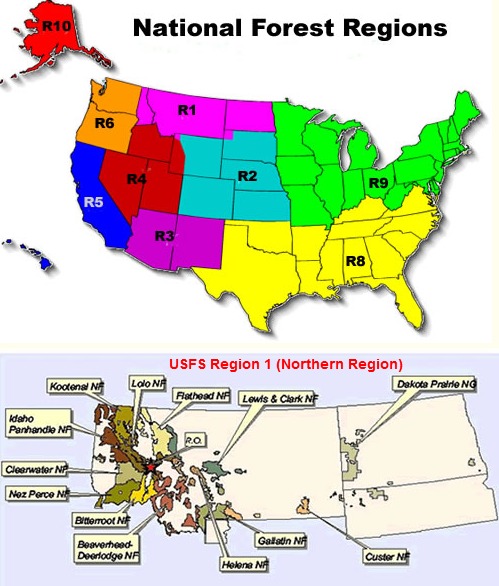
We have written about exploding targets numerous times, and applaud this decision by the USFS Northern Region. Hopefully the Regional Foresters in California, and Regions 4, 8, and 9 have the courage to take the same step. (See the map below to decode the region numbers.)

USFS Region 1

Thanks and a hat tip go out to Steve and Chuck.

California: Tomahawk Fire near Fallbrook

Tomahawk Fire
Tomahawk Fire, from Red Mountain at 2:24 p.m. PDT, May 14, 2014

(UPDATED at 7:27 p.m. PDT, May 15, 2014)

The fire is still reported to be 6,000 acres. A Type 2 Incident Management Team, with Incident Commander Garwood, is on scene.

****

(UPDATED at 8:59 p.m. PDT, May 14, 2014)

CAL FIRE reported at about 8 p.m. that the fire was 6,000 acres. It spread from the Naval Weapons Station near Fallbrook onto Camp Pendleton. 

****

(UPDATED at 4:40 p.m. PDT, May 14, 2014)

A change in wind direction has resulted in Fallbrook having an increased threat from the Tomahawk Fire that started just west of the community on Camp Pendleton. The wind is now from the west and southwest pushing the smoke, and possibly the fire, closer to the town.

CAL FIRE reports that the Tomahawk fire has burned 150 acres, and the Highway fire, near Interstate 15 and SR-76 has blackened about 600 acres with no containment. Evacuations are taking place in the area of the Tomahawk fire.

The Southern California Geographic Area Coordination Center reported at 4 p.m. that Interstate 15 is closed from 3.5 miles south of the junction of SR76 to 0.7 miles north of the junction of SR76 (San Diego County) as of 3:27 p.m. due to a wildfire. Possibly the Highway Fire which started near the intersection of I-15 and SR-76 is the culprit in the freeway closing issue. However, by 4:40 p.m. the Interstate reopened.

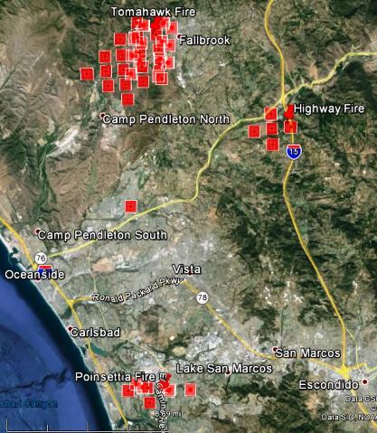
The updated map below shows the spread of the Highway, Tomahawk, and Poinsettia Fires.
Continue reading “California: Tomahawk Fire near Fallbrook”

California: Poinsettia Fire in Carlsbad

Map Poinsettia Fire, 1205 PDT, May 14, 2014
Map of the Poinsettia Fire, at 12:05 PDT, May 14, 2014, showing heat detected by a satellite. The location of the icons can be as much as a mile in error.

(UPDATED at 7:02 p.m. PDT, May 15, 2014)

All evacuation orders have been lifted for the 400-acre Poinsettia Fire in Carlsbad.

The fire is now considered a regional event.  As of 12 p.m. today, CAL FIRE Team 4 has assumed unified command for the fires burning throughout the county. This now is being referred as the “San Diego Complex.”  

A deceased person has been found inside the perimeter of the Poinsettia Fire.

The City announced today that during mopup of the 400-acre blaze, firefighters were alerted to a transient encampment in the area of Ambrosia and Calliandra.  On checking the area, firefighters located a badly burned body. Further details about the deceased are unknown at this time and the investigation is ongoing. There have been no other reported injuries or fatalities.

****

(UPDATED at 5:31 p.m. PDT, May 14, 2014)

Due to still another fire, the Washitonia Fire west of Escondido, the campus of Cal State San Marcos has been evacuated. The City of San Marcos (@sanmarcoscity) reported at 4:35 p.m. that all neighborhoods south of San Marcos Blvd, including Lake San Marcos, are under a mandatory evacuation order.

The updated map below shows the spread of the Highway, Tomahawk, and Poinsettia Fires.

Tomahawk, Poinsettia, Highway, Fires, 322 pm PDT, May 14, 2014
Tomahawk, Poinsettia, Highway, Fires, 3:22 p.m. PDT, May 14, 2014. The square red icons represent heat detected by a satellite; the location of the icons can be as much as a mile in error.

Continue reading “California: Poinsettia Fire in Carlsbad”

Colorado improves their wildfire suppression capability

Posted on Categories UncategorizedTags

Colorado will provide wildland firefighting resources this year that have not been available previously. The state has always been one of the least progressive or proactive in providing wildfire suppression resources and management. They have instead relied on local firefighters (who sometimes are very skilled) and an antiquated system in which the County Sheriff is responsible for fire suppression on non-federal land. Few County Sheriffs have advanced knowledge, skills, and abilities in wildland fire management so there is little innovation or use of modern wildland firefighting systems, organization, or technology outside of large cities at the local level. A few other states like Wyoming and Montana have similar systems. Texas is even more, uh, unique, with the County Judge being responsible for fire suppression in some areas.

New this year for the state of Colorado will be two multi-mission fixed wing aircraft that will provide intelligence on new fires within 60 minutes of the first report, four helicopters that can transport helitack crews and drop water, and two additional Single Engine Air Tankers (for a total of four SEATs). They expect to have two large air tankers in 2015.

This year for the first time Colorado “proposes”, to field two Wildland Fire Modules (WFMs), each staffed with ten individuals. Their purpose will be to conduct operations involving planned and unplanned wildland fire events. The WFMs will have expertise in the initial attack, ignition, holding, suppression, prescribed fire preparation and implementation support, hazard fuels reduction, aviation operations and fire effects monitoring. More information about the state’s aviation plans is at Fire Aviation.

Recently passed legislation in Colorado will create a “center of excellence for advanced technology aerial firefighting”, which will:

  • Serve as a laboratory to evaluate the “three fundamental contributing factors to successful aerial firefighting: effectiveness, efficiency, and sustainability”.
  • Conduct research to evaluate new technology in a variety of settings, such as initial attack, night operations, and operations in wildland-urban interface areas.
  • Produce data and documentation on science and technology relevant to aerial firefighting.

Other resources that will continue to be available in Colorado include three 20-member State Wildland Inmate Fire Team (SWIFT) crews, one each in Canon City, Buena Vista, and Rifle.

The state can also deploy 12 engines — 3 staffed by state employees, 5 staffed jointly by state and local agencies, and four call when needed engines operated by local agencies.

Red Flag Warnings, May 14, 2014

wildfire Red Flag Warnings -- May 14, 2014

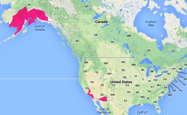
Warnings for elevated wildfire danger have been issued by the National Weather Service for areas in southern California, Arizona, and Alaska.

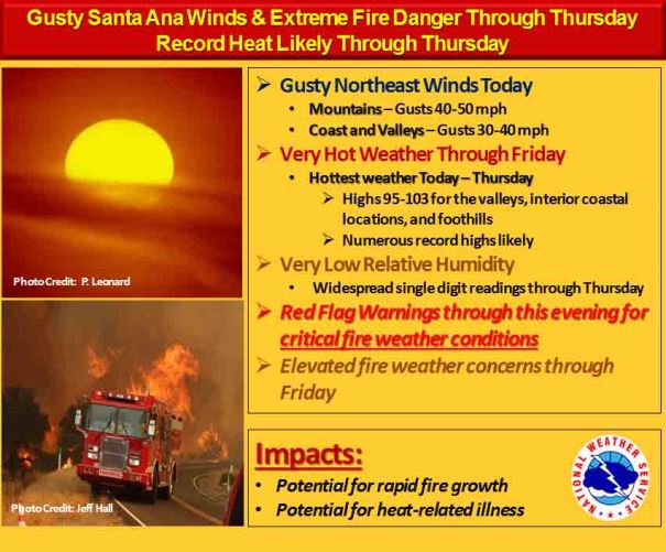
In southern California forecasters expect northeast to east winds to be stronger than yesterday, with gusts above 65 mph. Daytime temperatures will top out in the 90s to lower 100s, with humidity values ranging between 3 and 8 percent. The weather on Thursday will also be hot, dry, and windy.

Red Flag Warning, SoCal 5-14-2014

The Red Flag Warning map was current as of 11 a.m. MDT on Wednesday. Red Flag Warnings can change throughout the day as the National Weather Service offices around the country update and revise their forecasts. For the most current data, visit this NWS site.

California: Bernardo Fire near Rancho Santa Fe

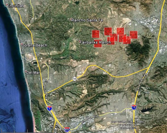
Map Bernardo Fire, north of San Diego, 2:52 pm PDT May 13, 2014
Map of heat detected on the Bernardo Fire, north of San Diego near Rancho Santa Fe, at 2:52 p.m. PDT May 13, 2014. The icons can be as much as a mile in error.

(UPDATE at 8:23 a.m. PDT, May 14, 2014)

All evacuations have been lifted for the Bernardo Fire north of San Diego at Rancho Santa Fe. The satellites that passed over the fire early Wednesday morning did not detect any large sources of heat or any additional fire spread.

San Diego Fire-Rescue reports Wednesday morning that 1,548 acres have burned and the fire is 25 percent contained. As of Tuesday night there were no reports of any homes burning, in spite of the fact that the fire burned through and adjacent to dense housing developments.

The weather on Wednesday will be a challenge for firefighters, who should expect 94 degrees, a relative humidity in the single digits, and by 11 a.m. 26 mph winds gusting up to 43 mph. By nightfall the winds will decrease to 10 mph or less and the humidity will rise to 39 percent by 1 a.m. Thursday.

The video report below was aired at 11 p.m. Tuesday night.

San Diego, California News Station – KFMB Channel 8 – cbs8.com

Police Chief Shelley Zimmerman said about 22,000 phone numbers that had registered with AlertSanDiego were sent evacuation alerts in the first hours after the fire started on Tuesday. It was first reported near Del Norte High School’s playing fields, on Nighthawk Lane and Camino San Bernardino in the city of San Diego, about 10:40 a.m.

The video below is a time-lapse of the fire as photographed from a camera system on Mt. Woodson.

 
Continue reading “California: Bernardo Fire near Rancho Santa Fe”