Burns most of the Redwood Mountain Grove, the largest grove of giant sequoia trees on earth.
1:30 p.m. PDT Oct. 5, 2021
KNP Complex map, north side. The red line was the perimeter at 7:30 p.m. Oct. 4, 2021. The green areas are the APPROXIMATE locations of groves of giant sequoias.
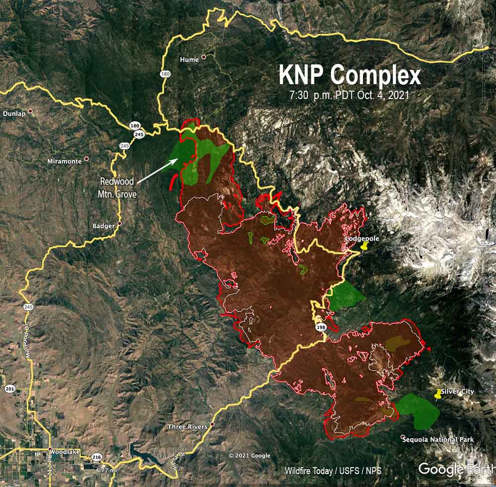
On Monday the KNP Complex of fires in Sequoia National Park, pushed by 55 mph winds, crossed Generals Highway about a mile east of Wilsonia. The extreme fire behavior forced firefighters to temporarily move to safer locations. The additional growth resulted in the fire becoming well established in Redwood Creek and burning much of the Redwood Mountain Grove, which is the largest grove of giant sequoia (Sequoiadendron giganteum) trees on earth. It contains the world’s tallest giant sequoia, 312 feet (95 meters). The amount of mortality of the sequoias is unknown at this point.
At least two very large pyrocumulus convection columns of smoke were seen Monday on the north side of the fire that rose to more than 32,000 feet, indicating extreme fire behavior.
This additional growth threatens Hartland, Quail Flat, Wilsonia, and Grant Grove. Firefighters are doing what they can to provide structure protection in these locations.
KNP Complex map. The red line was the perimeter at 7:30 p.m. Oct. 4, 2021. The white line was the perimeter about 48 hours before. The green areas are the APPROXIMATE locations of groves of giant sequoias.
The KNP Complex has burned 79,382 acres. Resources assigned include 27 hand crews, 90 engines, 35 water tenders, 18 dozers, and 13 helicopters for a total of 1,566 personnel.
On the southern side of the fire Monday, firefighters worked along Mineral King Road to contain the spot fires from Sunday night. They also provided structure protection in Silver City and the Mineral King area. Helicopters were able to support ground resources with bucket drops on Monday after the smoke cleared enough to safely fly.
On Tuesday crews are working on control lines to keep the fire out of the communities near the Redwood Mountain Grove on the north side of the blaze.
KNP Complex of fires. Uploaded to InciWeb Oct 4, 2021.
Map produced by a multi-mission aircraft Tuesday morning, Oct. 5; 964 acres.
Tuesday morning an aircraft mapped the Auburn Fire north of Rapid City and determined it had burned 964 acres.
Firefighters have conducted one or two firing operations on Tuesday to help secure the firelines. They are being assisted by a Type 1 helicopter which is dropping water.
Another fire broke out Tuesday in Southwest South Dakota 14 miles east of Hermosa and burned 650 acres on the Pine Ridge Reservation. Three single engine air tankers helped slow the spread.
10:34 a.m. MDT Oct. 5, 2021
The red dots on the map represent heat detected by satellites on the Auburn Fire as late as 2:54 a.m. MDT Oct. 5, 2021. Grass that burned and then cooled between overflights does not show up.
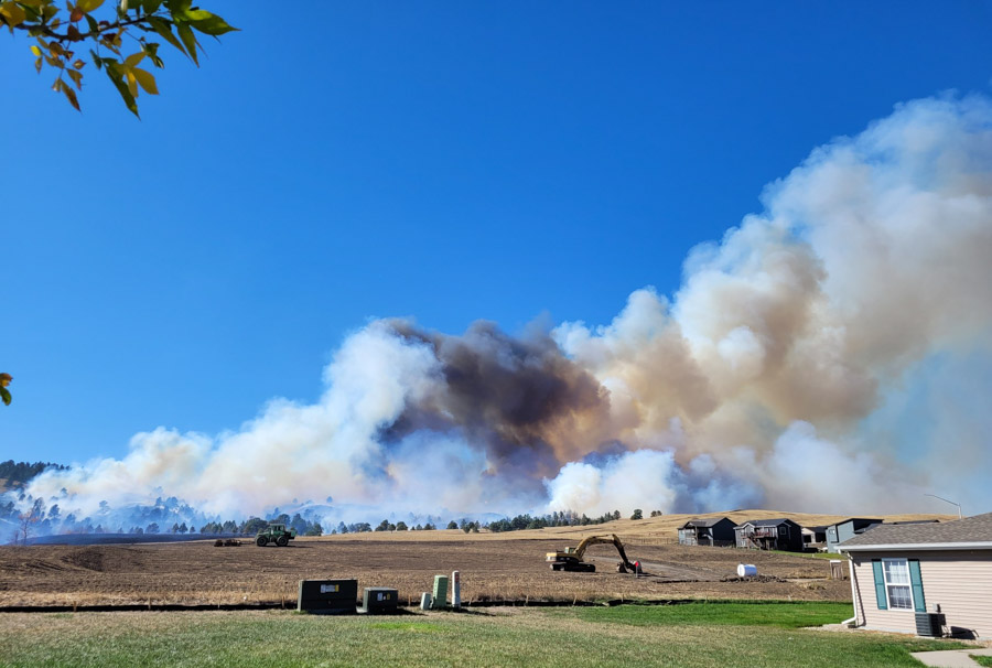
The Auburn Fire burned an estimated 500 to 750 acres north of Rapid City, South Dakota Monday. Overnight firefighters stopped the spread and completed a line around the blaze with the help of a tactical firing operation. Much of the fire burned through timber which will be smoking for days and will require extensive mop up.
It was reported at 1:49 p.m. Monday west of Auburn Drive between Haines and Deadwood Avenues north of Interstate 90. It started in Pennington County and spread north into Meade County.
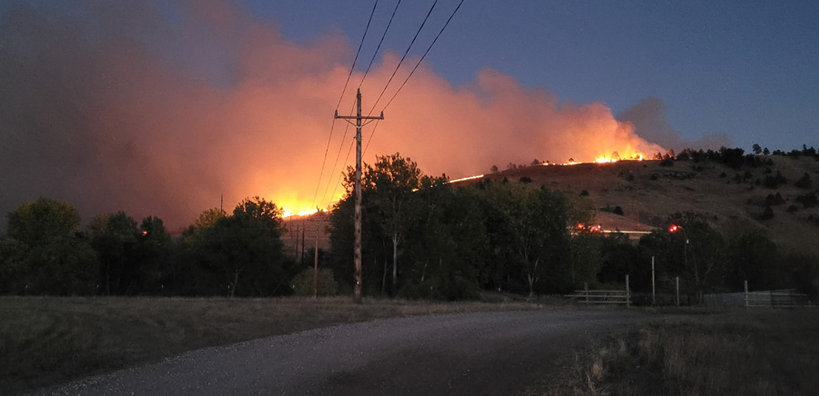
Auburn Fire – photo by Rapid City FD, Oct. 4, 2021.
Evacuations ordered Monday were still in effect Tuesday morning. The areas affected theoretically could be seen on a map. However, our experience was that the map was not visible on a Chrome browser, but it did work on Firefox and Safari.
There have been no reports of any structures destroyed.
Resources on the fire Monday included one large air tanker, a large type 1 helicopter, two single engine air tankers, dozers, and federal, state, and local firefighters.
The Rapid City air tanker base at the airport was activated to reload the air tankers.
Auburn Fire, Oct. 4, 2021, looking north from Mt. Rushmore Road/US 16. Photo by Pennington County Sheriffs Office.
Near critical fire weather conditions are expected through Wednesday. The forecast calls for temperatures to be in the upper 80s or lower 90s with relative humidity falling into the 7 to 20 percent range. Winds are expected to be out of the south at 10-20 mph.
The aircraft used Monday were still available Tuesday morning if needed.
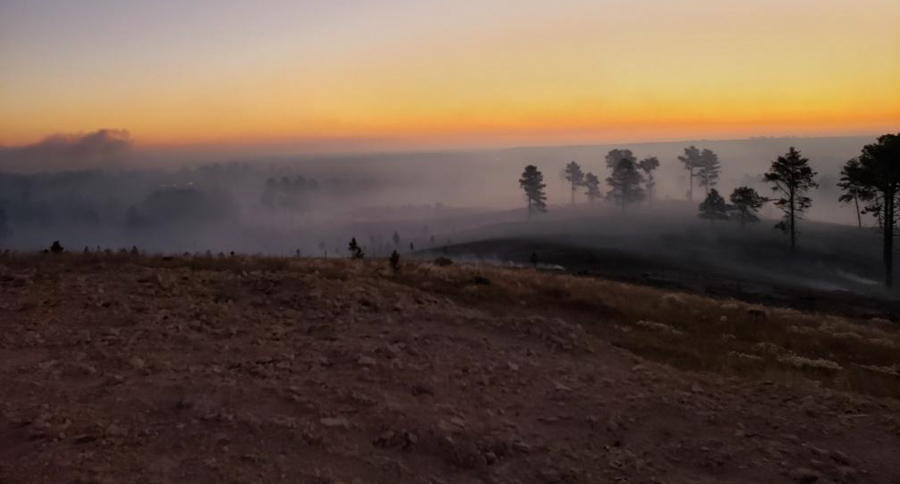
Dozer on the Auburn Fire, Oct. 4, 2021. Photo courtesy of Great Plains Fire Information.Auburn Fire – photo by Rapid City FD, Oct. 4, 2021.Auburn Fire – photo by Rapid City FD, Tuesday morning Oct. 5, 2021.
The firing operation on the north side of the KNP Complex along the Generals Highway/180 southeast of Wilsonia is moving along rapidly. It appears to have begun on Saturday, and by the time of the mapping flight Sunday night had spread half a mile to a mile south of the highway. It is now moving through the Redwood Mountain Grove, which is the largest grove of giant sequoia (Sequoiadendron giganteum) trees on earth. It contains the world’s tallest giant sequoia, 312 feet (95 meters).
Monday morning @mn_storm reported that a very large pyrocumulus convection column of smoke had been created that rose to 33,000 feet where the temperature reached -62°F. Monday afternoon @mm_storm said another pyrocumulus had reached 40,000 feet.
Nate Bogenschutz, an information officer for the fire, told Wildfire Today at 4 p.m. PDT Monday that the firing operation had remained within it’s intended boundaries and had not crossed Generals Highway/180. He said fire activity had increased around most of the fire today.
Our hope is that most of the smoke is not coming from the Redwood Mountain Grove and the tactical firing operation, and that the operation does not destroy large numbers of giant sequoia trees, which can live for more than 3,000 years old if climate change was not creating multi-year droughts and extremely low fuel moistures.
10:27 a.m. PDT Oct. 4, 2021
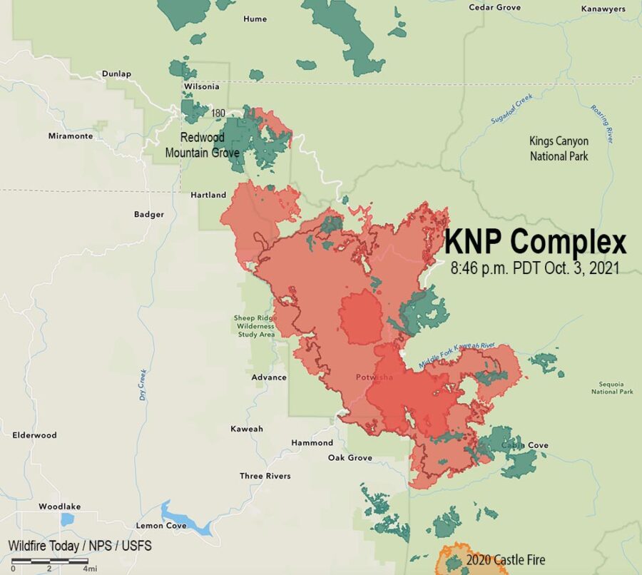
Map of the KNP Complex of fires, 8:46 p.m. Oct. 3, 2021. The dark red line was the perimeter on October 1. The green areas are groves of sequoia or redwood trees.
A drying trend over the last several days has led to an increase in fire behavior on the KNP Complex of fires in the Sequoia National Park in California. This has been especially apparent in lower elevations on the south and west sides where brush is the primary component of the vegetation.
Smoke trapped under an inversion has socked in the drainages and has limited the use of conventional aircraft for the last few days. However drones with infrared technology which can see through smoke have been flying, providing intelligence about the spread of the fire.
Map of the north side of the KNP Complex of fires, 8:46 p.m. Oct. 3, 2021, showing two firing operations. The dark red line was the perimeter on October 1. The green areas are groves of sequoia or redwood trees.
Two large firing operations are ongoing. On the north side near the Heartland community firefighters are working to keep the fire in Redwood Canyon, an area that is very steep and rugged all the way north to the Redwood Mountain Grove and the Generals Highway/180. The canyon is too steep and inaccessible and has multiple hazards, making it unsafe for firefighters. Saturday night a firing operation began at the highway to get the fire to back down the slope to the south, creating a buffer along the highway. By Sunday night fire personnel had ignited along four miles of the highway.
A few miles to the southeast, another firing operation is working north along the Generals Highway, starting near Dorst Campground. After it proceeds for a few miles, it will leave the highway to get onto a trail system to the west, closer to the fire, and will eventually meet up with the other operation which is working south off the highway.
KNP Complex of fires, Inyo Hotshots, Sept 29, 2021. InciWeb.
The incident management team is having difficulty obtaining the firefighting resources they need. This is due to several reasons, including the fact that some seasonal employees on hand and engine crews are reaching the end of their employment periods, and other fires are competing for the same types of resources.
Sunday night strong winds on the south side of the fire caused a spot fire across Mineral King Road which prompted an evacuation order for Crest, Sierra King, Hammond, and Oak Grove. Evacuation details are available on a map and at theTulare County Sheriff’s Facebook Page.
Helicopter waits for technicians installing a radio repeater on the KNP Complex of fires, Oct. 2, 2021. InciWeb.
She was asked about the provisions in the infrastructure bill that is now languishing in the House of Representatives after being passed in the Senate.
About 0.3 percent, or approximately $3,369,000,000 in this $1 trillion infrastructure bill is directed at wildland fire. Another much more controversial “reconciliation” bill, mostly about social programs that may spend more than $3 trillion, is much more controversial, but some politicians want the two bills to be passed at the same time.
In additional to customary infrastructure like roads and bridges, the $1 trillion infrastructure bill appropriates funds toward a couple of dozen wildland fire issues, most of which are important, but especially a few that have been near and dear to the hearts of Federal firefighters Forestry Technicians for years, especially the creation of a Wildland Firefighter occupational series. This would mean if the bill passes they will no longer be pigeonholed as they are now in a Forestry Technician job description. A bump in salary is also included.
The bill authorizes $600 million for management of personnel — those who fight fires.
The bill directs OPM to develop a distinct “wildland firefighter” occupational series.
The DOI and FS shall convert no fewer than 1,000 seasonal wildland firefighters to wildland firefighters that are full-time, permanent, year-round Federal employees who will reduce hazardous fuels on Federal land for at least 800 hours each year.
The base salaries of Federal wildland firefighters will be increased by the lesser of an amount that is commensurate with an increase of $20,000 per year or an amount equal to 50 percent of the base salary.
Develop mitigation strategies for wildland firefighters to minimize exposure due to line-of-duty environmental hazards.
Establish programs for permanent, temporary, seasonal, and year-round wildland firefighters to recognize and address mental health needs, including care for post-traumatic stress disorder.
Other provisions of the the bill that are related to Wildland fire. (M = million)
$20M, Satellite fire detection
$10M, Radio interoperability
$30M, Reverse 911 systems
$50M, Slip-on firefighting modules for pickup trucks
$100M, Pre-fire planning, and training personnel for wildland firefighting and vegetation treatments
$20M, Data management for fuels projects and large fires
$20M, Joint Fire Science Program (research)
$100M, Planning & implementing projects under the Collaborative Forest Landscape Restoration Program
$500M, Wildfire defense grants for at risk communities
$500M, Prescribed fires
$500M, Constructing fuelbreaks
$200M, Remove fuels, produce biochar and other innovative wood products
$200M, Post-fire restoration
$8M, Firewood banks
$10M, Wildfire detection and real-time monitoring equipment
One issue this legislation does not address is the inadequate funding of aerial firefighting — the use of air tankers and helicopters to assist firefighters on the ground by dropping water or retardant to slow the spread of wildfires, which is necessary for Homeland Security. The Federal agencies entered the year with 18 large air tankers and 28 large Type 1 helicopters, when they should have 40 large air tankers and 50 large helicopters on exclusive use 10-year contracts instead of the existing 1-year contracts.
The blaze has burned more than 92,000 acres in California.
9:02 a.m. PDT Oct. 3, 2021
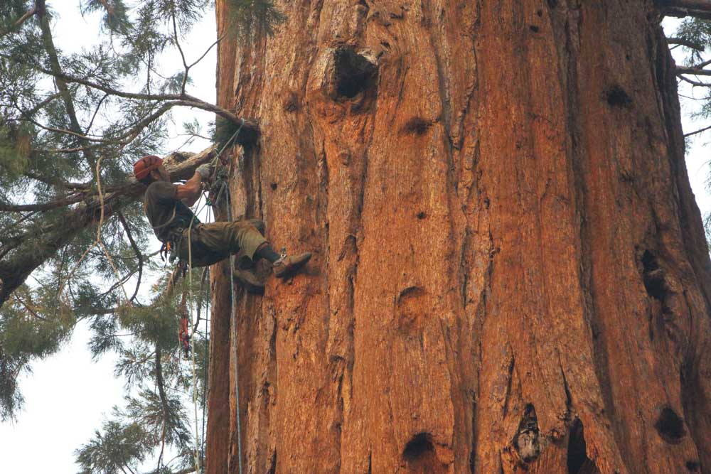
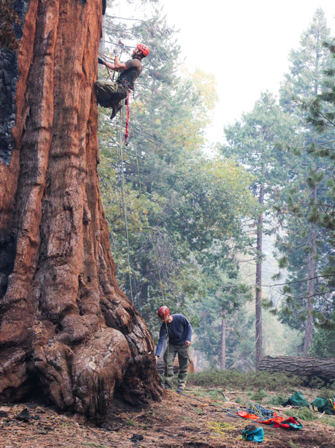
Rick Rataj and Tyler Anderson, USFS California Smokejumpers, climb a giant sequoia to investigate an area on the tree that is burning. Windy Fire, Sept. 30, 2021. BIA photo by Laura Scott.
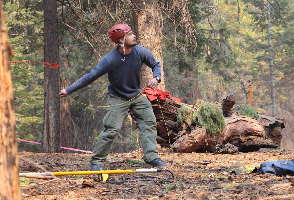
Smokejumpers who usually arrive at a fire by parachute have climbed at least one of the giant sequoia trees on the Windy Fire in California to investigate areas on the tree that were burning. The initial reports were that they would climb an adjacent tree and use a fire hose to apply water onto the burning tree. Smokejumpers are trained to climb trees in order to retrieve hung up chutes, but this is not a common task for them, climbing a tree that is burning. Usually they simply cut it down.
But these huge trees that can live for more than 3,000 years have been suffering during the multi-year drought and dry windy weather that has caused very low fuel moistures and intense fires that can penetrate the foot-thick bark. Last year the Castle Fire, just to the north (see map below), destroyed an estimated 7,500 to 10,600 large sequoias with trunk diameters of more than four feet, which was 10 to 14 percent of all large sequoias across the tree’s natural range in the Sierra Nevada.
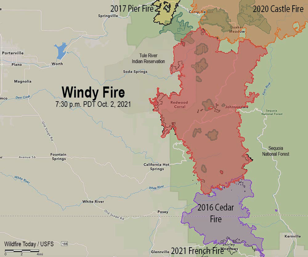
The red line on the map was the perimeter of the Windy Fire at 7:30 p.m. Oct. 2, 2021. The black line inside that, was the perimeter about 48 hours before. The darkest green areas are groves of giant sequoias.
The 92,473-acre Windy Fire has not spread as much in the last two days as it did earlier. Most of the additional growth was on the west side in and south of the Tule River Indian Reservation. During the Saturday night mapping flight the only large area with intense heat (dark red area on the map) was on the reservation.
Most of the north one-third of the fire has contained fireline, as do some of the areas around California Hot Springs, Pine Flat, and Sugarloaf Village but there is still work to do west of Fairview, on the Tule River Indian Reservation, and other locations near Sugarloaf Village.
Very dry daytime and nighttime conditions are expected to persist into early next week. On Sunday, the Kern River drainage will be very prone to strong winds, with gusts of 25–30 miles per hour; elsewhere, gusts will be up to 20 miles per hour. The result will be several hours of near-critical to critical fire weather conditions along the Kern River valley and adjacent slopes.
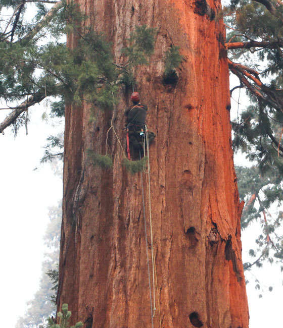
Rick Rataj and Tyler Anderson, USFS California Smokejumpers, utilize a “bigshot” to launch ropes into the branches of a giant sequoia tree so they can climb up to investigate heat left by the Windy Fire on September 30, 2021. BIA photo by Laura Scott.Rick Rataj and Tyler Anderson, USFS California Smokejumpers, climb a giant sequoia to investigate an area on the tree that is burning. Windy Fire, Sept. 30, 2021. BIA photo by Laura Scott.Rick Rataj and Tyler Anderson, USFS California Smokejumpers, climb a giant sequoia to investigate an area on the tree that is burning. Windy Fire, Sept. 30, 2021. BIA photo by Laura Scott.
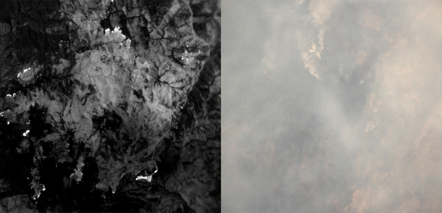
A thermal camera image (left) taken at the same time as a visible camera image (right). Both images were captured by one of Raven Aerostar’s Thunderhead Balloon Systems while station-seeking above and monitoring a wildfire. While billowing smoke obscures the visual image, active flames are identified as bright white markings on the thermal image, offering actionable information for containment efforts. Raven image.
When Bob, one of our readers, asked if I was aware that for several days a high altitude balloon had been seen on a flight tracking app maneuvering at 62,300 feet over the Dixie Fire in California I told him no, but I would check into it.
It was operated by Raven Aerostar, a company based near Sioux Falls, South Dakota, which has been working with lighter than air technologies since 1956. We contacted the Communications Manager for the company, Lisa McElrath, who told us that in June, July, and August they launched one of their Thunderhead Balloons from South Dakota and flew it west to monitor wildfires. While traveling more than 16,000 miles during its 70-day flight it engaged in station-seeking above four active fires — the Robertson Draw Fire (Mont.), the Dixie Fire (Calif.), the Dixie-Jumbo Fire (Idaho), and the Dry Gulch/Lick Creek fire (Wash.) — collecting visible and thermal imagery for extended periods of time.
Raven Aerostar balloon just after launch. Still image from the video below.
We asked Ms. McElrath if Raven been cooperating with the federal land management agencies in mapping fires. She said not yet, but that representatives from the National Interagency Fire Center had reached out to them and expressed interest in discussions after the fire season slows down.
“We can provide real-time imagery from the balloon today in the visible and infrared,” Ms. McElrath said. “In the future, the goal would be to automate the detection and download of critical imagery, fire perimeters, likely fire-starts, and other key information via onboard processing so that more actionable information would be available. We see stratospheric balloon technology being the key to cost-effective, scalable wildfire surveillance that reduces time between new fire detection and response. Effectively, balloons can alert firefighters to a new fire while it is still small, before the fire grows into something newsworthy and very expensive.”
She said the balloons can also serve as radio repeaters for personnel on the ground and could collect information from tracking devices on firefighting resources which could then be displayed on a map.
There are several paths that could lead to what we have called the Holy Grail of Wildland Firefighter Safety: knowing the real time location of a fire and firefighters. This could be one of them.
There are at least half a dozen companies in the U.S. that are working with high altitude balloons. Google Loon was one of them until they shut down a few months ago. Their goal was to help provide internet connectivity to the last one billion residents on the Earth, beaming it down from balloons. The company announced that it could not become commercially viable, around the time that thousands of SpaceX’s internet satellites were appearing in orbit.
The high altitude balloons navigate to locations by changing altitude to find wind directions that serve their needs.
“For the past nine years, Raven partnered with Loon on the development of this unique technology,” said Jim Nelson, Division Manager of Raven Aerostar. “Loon launched and navigated thousands of balloon platforms to help serve its mission. In parallel, we leveraged the Loon partnership and our 60-year history of balloon expertise to design and build our Thunderhead stratospheric platform. Thunderhead systems navigate using altitude steering, moving up and down to find favorable winds, just as the Loon balloons did. Because no lift gas or ballast is consumed during maneuvering, Thunderhead balloons can remain aloft for weeks to months at a time.”
The stratospheric balloon system works best in fleets or constellations of balloons that share wind information to improve navigation and share the sensor workload. This is explained in the video above.
All of the electrical power on the balloons comes from solar panels, which charge batteries for night operations.