Infrared mapping, the New York Times on Lassen’s Reading Fire, and more Yarnell Hill articles

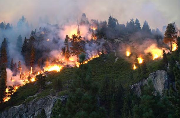
Reading Fire
Reading Fire. Photo by Lassen National Park.

Several online articles came to our attention today that you may be interested in.

New York Times

The Times has an excellent article about last year’s Reading Fire in Lassen National Park in northern California. It was a fire use fire that started on July 23, 2012, escaped the maximum management area, and burned outside the park, blackening a total of 28,000 acres. The author, Paul Tullis, oddly, but in a very interesting way, also writes about fire behavior research being conducted at the Missoula Fire Lab. Checking out the article is worth it, if only for the great photos taken by photographer Richard Barnes.

More articles about the Yarnell Hill Fire

The monthly magazines are now coming out with their articles about the fire on which 19 members of the Granite Mountain Hotshots died. They pale in comparison to the good one that was in Outside Magazine, but if you are obsessed with that multiple fatality incident, like many of us are, you’ll want to see the articles in Popular Mechanics and Men’s Journal.

The USFS infrared mapping program
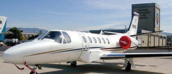
USFS IR aircraft, Cessna Citation Bravo
One of the U.S. Forest Service’s Infrared aircraft, their Cessna Citation Bravo, N144Z, parked at NIFC in Boise.

Earthzine has an article that does a good job of summarizing the U.S. Forest Service program that operates two fixed wing aircraft that map ongoing wildfires. Here is an excerpt:

…The two IR aircraft are a twin-engine Beechcraft Super King Air B-200 and a small jet, the Cessna Citation Bravo II. Both aircraft take off at between 7-9 p.m. and continuing mapping runs until 4 a.m.

Mapping flights follow a grid plotted out in advance, at an altitude of 10,000- 14,000 feet. From that height, each pass scans a swath 6.5 miles wide. For accuracy, passes overlap each other by 25-30 percent. Flying at 300 miles per hour, a map produced by the Super King is accurate by plus or minus 1 foot. The faster moving jet is only slightly less precise – providing maps accurate to plus or minus 10 feet.

The imagery is sent in real-time to interpreters on the ground while the aircraft are still making runs over a fire. Some 48 interpreters are scattered across the country and will have completed maps on the screens of firefighter command centers before the aircraft make their last landings of the night.

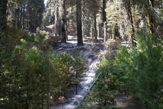
Rim fire burn area: “nuked” or not?

The Associated Press, in an article written by Tracie Cone, quotes Jay Miller, a U.S. Forest Service “Fire ecologist”, as saying the area burned by the Rim Fire in California has been “nuked” and “everything is dead”.

…The fire has consumed about 400 square miles, and within that footprint are a solid 60 square miles that burned so intensely that everything is dead, researchers said.

“In other words, it’s nuked,” said Jay Miller, senior wildland fire ecologist with the U.S. Forest Service. “If you asked most of the fire ecologists working in the Sierra Nevada, they would call this unprecedented.”

Smaller pockets inside the fire’s footprint also burned hot enough to wipe out trees and other vegetation.

In total, Miller estimates that almost 40 percent of the area inside the fire’s boundary is nothing but charred land. Other areas that burned left trees scarred but alive.

The excerpt below was written by the Rim Fire Burned Area Emergency Response (BAER) team which paints a very different picture than the one above from the Associated Press and Mr. Miller.

SONORA CA (September 16, 2013) – The BAER team completed the soil burn severity map for the Rim Fire. The map using burned acres as of September 13 shows that approximately 56% of the 254 926 acres within the Rim fire perimeter are either unburned or received a low-severity burn 37% sustained a burn of a moderate severity and approximately 7% burned at a high severity.

BAER specialists concluded that the amount of high severity burn is fairly low given time of year and comparison to other fires. The moderate and low severity burned areas are fairly high for similar reasons. These values are for the entire burn area of the Rim Fire. The soil burn severity BAER map can be downloaded at the “Rim Post-Fire BAER” InciWeb site as JPEG or PDF.

Near the end of the AP article there is a different point of view from Mr. Miller’s”

“It really burned here much like a prescribed fire would to a large degree because of land management practices,” Holbeck said. “Fire plays a natural part of that system. It can’t all be old growth forests, though Yosemite holds some of the oldest trees in the Sierra.”

Rim Fire, east side of Bourland drainage, USFS photo by Louis Haynes
Undated photo of the Rim Fire, east side of Bourland drainage. USFS photo by Louis Haynes from the BAER team Inciweb website.

The Rim Fire, which started August 17, has burned 256,895 acres in and near Yosemite National Park in California and is listed at 84 percent contained. It still has 1,371 personnel assigned.

Our take on the Associated Press article

We don’t know if Tracie Cone accurately quoted USFS “Fire Ecologist” Jay Miller, but if so, it is inconceivable that Mr. Miller’s description of the burn severity would appear so starkly in contrast to that presented by the BAER team. It would also be interesting to know if Mr. Miller was on the BAER team or if he has been on the ground at the Rim Fire. We are not aware of any reputable, experienced wildland fire manager or fire scientist who would ever use the terms “nuked” or “everything is dead” to describe the effects found on a very large fire that burned for weeks in various weather, topography, and vegetation conditions.

Based on the AP article and the reports from the BAER team, we have little confidence in the accuracy of the information attributed to Mr. Miller that was presented by the Associated Press.

A call to Mr. Miller, who is listed in the USFS directory as a Remote Sensing Specialist, was not immediately returned. We also called the Rim Fire incident Management Team for a comment on the article, and spokesperson Sean Collins told us it was their policy to not comment on the “opinions” of others in regard to the burn severity.

(UPDATE September 23, 2013: more information about different kinds of maps showing vegetation and soil severity.)

Wildfire smoke in Reno similar to air in casinos

Researchers at the University of Nevada said the smoky air that enveloped Reno while the Rim Fire in Yosemite National Park was burning was no worse than the air patrons breathe on the casino floors in the city.

Wildfire smoke map
Wildfire smoke map August 25, 2013

South Dakota: Cascade Fire

(UPDATED at 2:42 p.m. MDT, September 27, 2013)

Firefighters on the Cascade Fire 3 miles south of Hot Springs, South Dakota said it has burned 45 to 50 79.5 acres and they are calling it 80 percent contained. A National Guard Blackhawk helicopter will be assigned to the fire today along with two hand crews, a dozer, and an assortment of engines from federal, state, and volunteer agencies. A Single Engine Air Tanker is also available if needed.

Scroll down to see a slide show of photos from the fire.

****

(Originally posted at 2:43 p.m. MDT, September 18, 2013; updated at 8:17 p.m. MDT)

The Cascade Fire, 3 miles south of Hot Springs, South Dakota, was reported at about 2 p.m. MDT on Wednesday. By 2:30 it had blackened at least 5 acres and burned over the top of the Seven Sisters ridge. A couple of hours later the size was estimated at 15 to 20 acres and was being fought by state, federal, and local fire departments. At 8 p.m. the incident commander called it 40 percent contained.

The fire appeared to be burning on private land, but that was not confirmed.

A single engine air tanker (SEAT), Tanker 463 from Valentine, Nebraska, made its first drop over the fire at 3:56 p.m. At around 4:15 p.m. the Incident Commander inquired into the availability of a large air tanker. About 20 minutes later the dispatcher told him the closest one was in Idaho. Later I checked a map and that would have been 400 to 650 miles away.

After 5:00 p.m. a National Guard Blackhawk helicopter with a bucket was on scene. A second SEAT also dropped on the fire according to a spokesperson for the fire. The SEATs were from South Dakota and Valentine, Nebraska. They reloaded and refueled at the Hot Springs, SD airport, about five miles east of the fire.

All of these photos were taken by Bill Gabbert, except for the one of the SEAT refueling, which was supplied by South Dakota Wildland Fire.

[portfolio_slideshow]

Steven Pyne: Our approach to wildfires is all wrong

USFS engine crew on the White Draw Fire
USFS engine crew on the White Draw Fire, July 29, 2012. Photo by Bill Gabbert.

Steven Pyne, the author of many books about wildland fire, has written an amazing op/ed piece for the Washington Post titled “From Yosemite to Colorado, our approach to wildfires is all wrong”.

It is the most interesting article I have read in a long time, due in part, of course, to the wisdom of his ideas about how to coexist with the wildfire problems facing us. But what makes it a joy to read is his extraordinary gift as a wordsmith. About every third sentence I encountered a word, phrase, or a way of looking at an issue that was surprising, in a good way — arrangements of words that have rarely if ever been used in the context of wildland fire management.

You must read it, but here are some examples:

  • “misdiagnosed the problem”
  • “retrofitting houses”
  • “irrationally exuberant sprawl”
  • “fire repression”
  • “translating ideas into programs”
  • “pluralism of fire programs”
  • “ill-sited McMansions”
  • “climate change may flip the script”
  • “fire equivalent of a flood plain”
  • “emergency interventions rather than systemic reforms”

You are welcome.


Thanks go out to Bruce

FEMA’s wildland fatality statistics, 2012

The Federal Emergency Management Agency and the U.S. Fire Administration have released their annual report about the number of firefighter fatalities for 2012. This year their numbers for those killed on wildland fires are the same as those provided by the National Wildfire Coordination Group, which is not always the case.

According to the report:

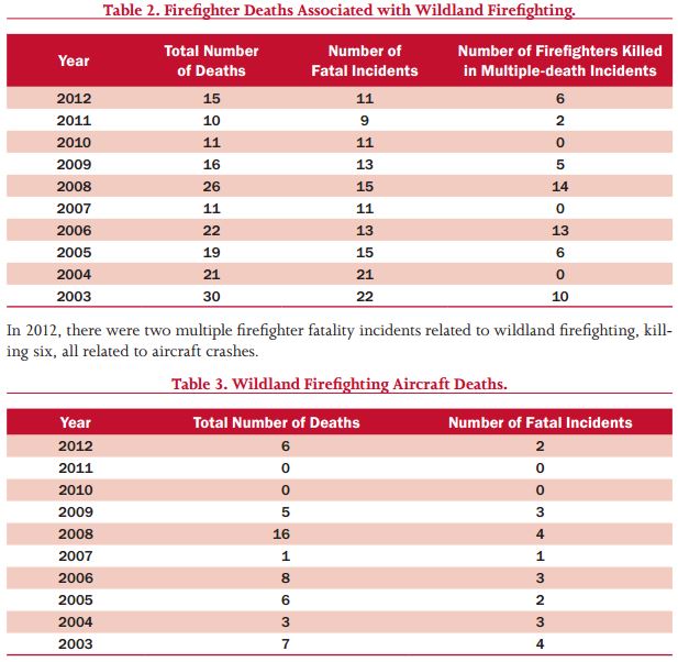
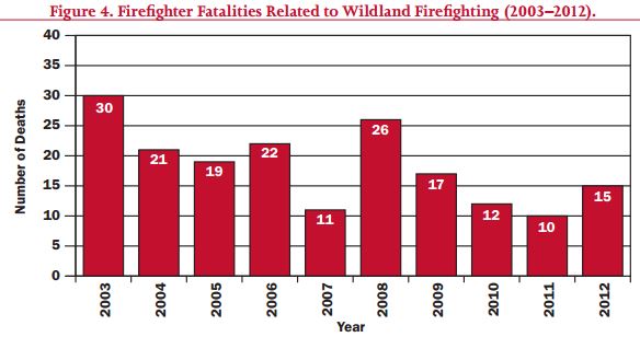
In 2012, 15 firefighters were killed during activities involving brush, grass or wildland firefighting. This total includes part-time and seasonal wildland firefighters, full-time wildland firefighters, and municipal or volunteer firefighters whose deaths are related to a wildland fire.

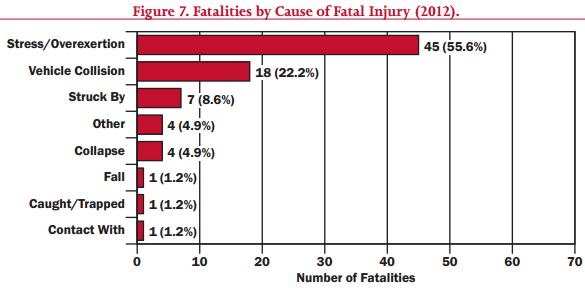
Below are some graphics from the report:

Wildland firefighter fatalities, aircraft, 2003 - 2012

Wildland firefighter fatalities, 2003 - 2012.As usual, for all firefighter deaths, wildland and other, the two leading causes, by far, were “stress/overexertion” and “vehicle collision”, accounting for 78 percent of all fatalities.

Cause of firefighter fatalities. FEMA.