California: Morgan fire

(UPDATED at 8:30 a.m. PDT, September 10, 2013)

The spread of the Morgan Fire in Mt. Diablo State Park 18 miles east of Berkeley, California slowed late in the day on Monday. More accurate mapping resulted in a decrease in acreage, from 3,718 to 3,243 acres by Tuesday morning. The incident commander is calling it 45 percent contained, up from 20 percent on Monday.

KTVU has an interesting timelapse video of the fire.

****
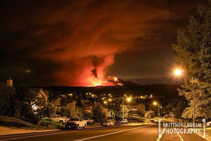
Morgan Fire
Morgan Fire as seen from Brentwood, September 8, 2013. Photo by Brittney Lauren.

(UPDATED at 4:57 p.m. PDT, September 9, 2013)

The Morgan Fire east of the San Francisco Bay area has grown to 3,718 acres, and the Incident Commander is calling it 20 percent contained.

****

(Originally published at 12:33 p.m. PDT, September 9, 2013)

The Morgan Fire is burning in Mt. Diablo State Park 18 miles east of Berkeley, California (see the map below). It started Sunday at 1 p.m. and burned actively all night. The fire is currently threatening PG&E electrical transmission lines, communications infrastructure on Mt. Diablo, and historical buildings at the summit of Mt. Diablo. At 11:30 a.m. on Monday CAL FIRE said it had burned 1,500 acres.

Map of Morgan Fire 3:12 a.m. PDT, September 9, 2013
Map of the Morgan Fire. The red squares represent heat detected by a satellite at 3:12 a.m. PDT, September 9, 2013. (click to enlarge)

Mandatory evacuations have been ordered for Oak Hill Lane, Curry Canyon, Curry Lane, Curry Point, Trail Ride Road, East Trail Road, Russelman Park Road, Upper Trail Road and Lower Trail Road.

The fire is being fought by 705 personnel, 85 engines, 30 hand crews, and 11 dozers.

Morgan Fire at 12:25 p.m. PDT, September 9, 2013
An engine with one firefighter out on the ground attempts to hold a road above a very active portion of the Morgan Fire at 12:25 p.m. PDT, September 9, 2013. Photo by NBC Bay Area.

These sites occasionally have live video feeds of the fire: KTVU, Dropcam, ABC7news, and NBC Bay Area. And there’s a web cam that needs to be refreshed to see the latest images: Mt. Diablo Cam.

After a fire, before a flood: NASA’s Landsat directs restoration to at-risk areas

While the 138,000-acre Silver Fire in New Mexico still smoldered, forest restoration specialists were on the job in August. They analyzed maps created using Landsat satellite data to determine where the burn destroyed vegetation and exposed soil – and where to focus emergency restoration efforts.

Silver Fire burn severity
The soil burn severity map of the New Mexico Silver Fire shows areas that with high (red), medium (yellow) and low (green) severity burns. Image Credit: USDA Forest Service, Burned Area Emergency Response Team

“The map looked like a big red blob,” said Penny Luehring, the U.S. Forest Service’s Burned Area Emergency Response and watershed improvement program leader, based in Albuquerque, N.M.

Red means high-severity fire, she explained – and the red areas were concentrated in a watershed drainage that fed communities west of Las Cruces, N.M. So crews got to work. The Burned Area Emergency Response, or BAER, teams are designed to go in as soon as the flames die down to help protect reservoirs, watersheds and infrastructure from post-fire floods and erosion. And Landsat satellites, built by NASA and operated by the U.S. Geological Survey, help direct the crews to those forest areas needing attention.

As a wildfire starts to die down, fire managers like Luehring can contact the Forest Service’s Remote Sensing Applications Center in Salt Lake City to request maps that identify the high, moderate and low severity burns. When that call comes in, remote sensing specialist Carl Albury finds satellite imagery of the burned forest both pre- and post-fire.

In Landsat images, he looks at two of the 11 spectral bands – the near-infrared band and a short-wave infrared band.

“The near infrared reflects well from healthy vegetation, and the short-wave infrared bands reflect well from exposed ground,” Albury said. “By comparing the normalized ratio of the near- and shortwave-infrared bands in the pre-fire image to the post-fire image, we can estimate the burn severity.”
Continue reading “After a fire, before a flood: NASA’s Landsat directs restoration to at-risk areas”

Great Basin Coordination Centers to merge

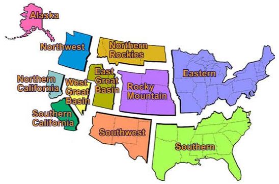
GAAC mapThe Eastern Great Basin and Western Great Basin Coordination Centers will merge and be located in a new facility in Salt Lake City. The federal agencies involved say the consolidation will save money and improve response time in getting resources to wildfires and other incidents. The centers, currently located in Salt Lake City and Reno, are responsible for mobilizing resources for wildland fire, prescribed fire and other all-hazard incidents primarily in Nevada, Utah and southern Idaho, plus small portions of California, Wyoming and Arizona.

The decision to consolidate was made after a study by the participating agencies that examined criteria including the safety of the public and firefighters; providing services at the same or higher level than the two existing organizations; proximity to other offices and an airport; minimal disruption to employees; technological capabilities; and overall efficiency. The consolidation will save about $305,000 a year after one-time moving expenses and will affect up to five employees in Reno, all of whom will be offered positions at the new center.

The coordination centers are two of eleven such organizations throughout the country. The centers also provide intelligence and meteorological products to wildfire personnel. Participating agencies include the states of Nevada, Utah and Idaho; BLM; the Forest Service; Bureau of Indian Affairs; National Park Service; and the Fish and Wildlife Service.

Five options were considered, ranging from status quo to consolidating facilities in Salt Lake City, Reno or Boise.

The target start-up date for the new Great Basin Geographic Area Coordination Center is April 2014.

****

Our thoughts

I always thought it was strange that the Great Basin was divided into basically two Geographic Area Coordination Centers —  and, that California is broken up into two as well. How long do you think it will before California’s North Zone and South Zone merge?

Body of missing firefighter discovered in New Mexico

(UPDATE at 9:50 a.m. MDT, September 11, 2013)

The memorial service for Captain Token Adams will be Thursday September 12th, 2013 at 10:00 am at:

Calvary of Albuquerque
4001 Osuna Rd. NE
Albuquerque NM 87109

To get further information about the service please go to www.danielsfuneral.com.

****

Token Adams
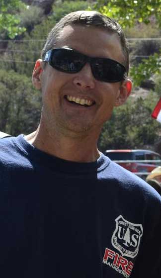
Token Adams, USFS photo

The body of U.S. Forest Service Engine Captain Token Adams was found today. Missing since Friday, August 30, he was last seen when he boarded an ATV to attempt to locate a smoke that had been reported on the Santa Fe National Forest in northern New Mexico. His crew of three split up when they arrived at the general location of a smoke report but he did not return to the agreed upon meeting place. For the last eight days hundreds of people have been searching for him over dozens of square miles of the National Forest.

At 11:45 a.m. today searchers discovered his remains about one-quarter mile from the nearest road. In a video about this development at KRQE, the reporter said there was an apparent crash of the ATV and that Captain Adams had been wearing full protective gear, but the exact cause of death has not been determined.

Below is an announcement issued Friday afternoon by the Incident Management Team managing the search organization:

Friday September 6 2013 – 4:45 pm

We are sad to announce that the body of Jemez Ranger District Engine Captain Token Adams has been located. Token was dispatched to locate a smoke reported on Friday August 30 2013. Search efforts began late Friday afternoon and continued through this morning when his body was discovered.

Token was an Engine Captain working in Jemez Springs NM. He was 41 years old and had been an Engine Captain on the Jemez Ranger District for 1 ½ years. He was a wildland firefighter for 10 years including previous experience as a hotshot. Before coming to the Forest Service Token served in the U.S. Navy. Token grew up in the community of Coarsegold California and was a 1990 graduate of Yosemite High School in Oakhurst California.

Token is survived by his wife Heidi a 3 year old son Tristan his mother a brother and sister. Token’s wife Heidi is expecting their second child.

All public and media are asked to please respect the privacy of the firefighter’s family during this time of mourning. We will release all details of this tragedy when more information becomes available.

Wildfire Today had been publishing daily updates on the search since it became public on September 2, 2013.

Our sincere condolences go out to the family and co-workers of Captain Adams.

Wildfire briefing, September 6, 2013

Scientists expect fire risk in the U.S. to escalate by the end of the century

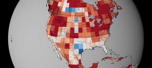
Map elevated wildfire risk, climate changeHot and dry conditions lead to more fires. Those were the findings presented in 2012 by a team of researchers that used NASA satellite data and climate models to predict fire activity in the United States. Now, a new animation shows how dry conditions will cause different parts of the U.S., Canada and Mexico to experience an increased risk of fire by the end of the century. By mapping projected values for a measure of dryness known as the potential evaporation—a calculation that’s based on temperature, rainfall and wind speed estimates—scientists are able to interpret how fire activity will be influenced by future climates. Changes in dryness relative to 1980 levels are shown in the animation using colors, where reds represent an increase in dryness and blues represent a decrease. Watch the video to see how dry conditions are expected to spread across North America by the year 2100.

Another firefighter fatality in Portugal

A seventh firefighter in a month passed away in a hospital in Portugal after suffering burn injuries on a wildland fire last week.

MAFFS demobilized

Five military Modular Airborne FireFighting System C-130 air tankers were released  from fire suppression duty yesterday. Since the year’s initial activation June 11, MAFFS crews have flown 572 missions and made 535 drops using 1,375,981 gallons of fire retardant. That works out to 2,406 gallons per mission.

Granite Mountain Hotshots memorial items to be removed

Soon after 19 members of the Granite Mountain Hotshots were killed on the Yarnell Hill Fire on June 30, mourners began placing memorial items on the fence surrounding their compound at the Prescott Fire Department. Now over two months later the city decided they have to do something with the hundreds of objects which include T-shirts, photos, posters, and other items. The City announced Thursday that the Fire Department and area volunteers would begin to remove them on Sept. 10.

Below is an excerpt from an article in the Daily Courier:

Now, officials say, it is time to begin packing away the items for preservation, and possible inclusion in a more permanent memorial in the future.

“Items that are able to be preserved will be temporarily stored until plans are finalized for the future permanent memorial,” the city’s new release stated.

City officials have noted that the outdoor elements have taken a toll on many of the items. Flowers, cardboard signs, and other perishable items were earlier removed. Many of the T-shirts from fire departments around the country have faded from dark-blue to gray.


Wildfire briefing, September 5, 2013

Investigators determine cause of Rim Fire

Investigators from the U.S. Forest Service and the Tuolumne County District Attorney’s Office have determined that the 237,000-acre Rim Fire in central California began when a hunter allowed an illegal fire to escape. Contrary to speculation earlier by Todd McNeal, fire chief in Twain Harte, there is no indication the hunter was involved with illegal marijuana cultivation and no marijuana cultivation sites were located near the origin of the fire.

Animation of the spread of the Rim Fire

An animation of the spread of the Rim Fire will entertain you for a few minutes. It is fascinating to watch as the fire spreads, burnouts are completed, and sections of the fire become smaller as data collected during GPS helicopter flights around the fire are later corrected by infrared mapping.

Dozer operator injured in rollover

The Idaho Statesman reported that a dozer operator was seriously injured Monday during a rollover while he was constructing a helispot on the Raft Fire, part of the Weiser Complex. Timothy Harrison, 55, was hospitalized in critical condition. The U.S. Forest Service is conducting an investigation into the accident.

Arizona Governor to appeal federal aid for Yarnell Hill Fire

Arizona Governor Jan Brewer reportedly plans to appeal the decision by FEMA which declined to provide federal aid for the Yarnell Hill Fire. FEMA’s rationale was that few of the homeowners who lost their residences in the fire did not have insurance. On June 30, 19 members of the Granite Mountain Hotshots were killed on the fire.


Thanks go out to JW