Utah: Rockport fire burns structures

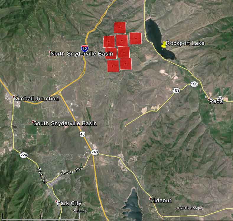
Map showing approximate locations of heat detected on the Rockport Fire
Map showing approximate locations of heat detected on the Rockport Fire at 2:39 p.m. MDT, August 14, 2013 (click to enlarge)

The map above shows the approximate location of the Rockport Fire that has burned at least 13 residences, approximately 20 outbuildings, several vehicles, and 2,000 acres near Rockport, about 8 miles northeast of Park City, Utah. The red squares indicate heat detected by a satellite, but the locations can be off by as much as a mile. The map indicates that the fire is burning through a populated area with homes on large lots.

It started Tuesday afternoon and slowed overnight and Wednesday morning but it was active enough at about 3:30 p.m. Wednesday that a scheduled press briefing had to be relocated from Wanshop (north of Rockport Lake) to the Summit County Justice Center in Park City due to “media and staff safety”.

A reminder: firefighters’ lives vs. saving structures

Posted on Categories Uncategorized

As we enter what is typically the busiest part of the western wildland fire season, and with the deaths of 19 hotshots still fresh in our minds, this is a good time to review some words from Tom Boatner that were in a wildland-urban interface course video. Mr. Boatner, now retired, was the Chief, Division of Fire Operations, for the BLM Office of Fire and Aviation in Boise.

Jump to 36:43 and just watch the last 2 minutes, where his remarks begin.

Thanks go out to Brit

Idaho wildfires creating massive travelling smoke plume

The wildfires east of Boise, Idaho, with the Elk Complex and Beaver Fire being the primary suspects, put up a massive pyrocumulus cloud and smoke plume on Tuesday that by mid-day on Wednesday had moved into Wyoming and eastern Montana. It should be over South Dakota later today.

Wildfire smoke, at 11:21 a.m. MDT, August 14, 2013
Wildfire smoke, at 11:21 a.m. MDT, August 14, 2013 (click to enlarge)

Darren R. Clabo, the South Dakota State Fire Meteorologist, alerted us to this and sent us the links to satellite imagery, below, via Mike Fromm.. The second one may take a long time to load, but after it does, the video moves along at a good clip.

Video of clouds and smoke, western United States.

Closer view with IR, video.

In recent years, scientists and fire behavior analysts have tracked smoke plumes like this while they made multiple trips around the Earth.

Wildfire briefing, August 14, 2013

Firefighter deaths resulting in changes

Rocky Barker of the Idaho Statesman has written an interesting article about how the death of 20-year old Anne Veseth of Moscow, Idaho a year ago this week has changed procedures in some wildfire organizations. She was killed on the Steep Corner Fire, 56 miles northeast of Orofino, Idaho August 12, 2012. The fire was on private property and was being managed by the Clearwater‐Potlatch Timber Protective Association (CPTPA). Ms. Veseth, in her second season working as a firefighter for the USFS, was killed when she was struck by a falling 150-foot tall fire-weakened green cedar tree. The tree fell on its own and was 13 inches in diameter where it struck her. The official report about the fire found no fault, and included this statement:

This tragedy resulted from the chance alignment of certain conditions: an emergency response to control a wildland fire, which required the presence of firefighters in an area where fire‐weakened trees could fall on their own with little or no warning.

The day before the fatality, a Hotshot crew and an engine crew refused to work on the fire after they observed serious safety issues.

Plane crash starts small fire

The crash of a small plane in northern California killed the two people on board and started a vegetation fire that burned 15 acres before firefighters stopped the spread. Federal Aviation Administration spokesman Ian Gregor says the plane crashed at about 11:30 a.m. Tuesday about five miles east of Chico in Butte County.

Large firewhirl photographed

A large fire whirl, sometimes called a fire tornado, was photographed on the Summit (name changed to Rockport) Fire north of Park City Utah on August 13. A new term has been introduced. Some people are calling this a “firenado”, which could be a takeoff from the “Sharknado” movie.
 

NPR profiles Jeanne Pincha-Tulley

Jeanne Pincha-Tulley has been a Type 1 Incident Commander for nine years. Almost long enough for the novelty of having a female Type 1 IC wear off among other firefighters.

While her team was managing the Mountain Fire in southern California last month between Idyllwild and Palm Springs, National Public Radio did a profile on her. You can listen to it or read the article at the NPR site.

Below is an excerpt from the article:

…Pincha-Tulley listens and texts other members of the team while Lane continues with his update. Being in the incident commander’s trailer is like being in a hive. There’s a near-constant buzz.

People come in and out; phones ring; radios squawk; lunches go uneaten.

In the time it takes [Operations Section Chief John] Lane to give an update, the area fire chief for Cal Fire walks in, as well as a liaison for the sheriff’s office, a member from communications and a guy from finance. Pincha-Tulley scribbles her signature on a form as a radio update comes in.

“And secondly, the retardant line with the helicopter across that ridge there heading towards the wilderness is progressing really well,” according to the update.

Lane then explains that the fire has crossed over their containment line in one section. They’re calling in the largest air tankers, DC-10s — or VLATs for Very Large Air Tankers, as firefighters call them — to try to box in the new threat before it spreads. Pincha-Tulley asks how that’s progressing when the radio squawks again: “So far we’ve been pretty successful with that.”

“There’s your answer,” Lane tells her. “It’s being dealt with.”

In 2008 and 2010 Ms. Pincha-Tulley was in the news for managing the 48,520-acre Castle Rock Fire in Idaho as well as other fires, here, here, and here.