KNP Complex of fires, Sequoia Kings Canyon National Park in Southern California
5:51 a.m. PDT Sept. 17, 2021
KNP Complex of fires, 3-D map, looking northeast, 8 p.m. PDT Sept. 16, 2021. The bright red areas had intense heat when the fire was mapped. Green represents the approximate location of giant sequoia groves.
In order to protect the largest tree in the world from a wildfire in Sequoia National Park extraordinary measures are being taken. In an effort to prepare a grove of giant sequoias for the expected spread of the KNP Complex of fires into the area, personnel are attaching fire resistant material usually used on structures on some of the iconic monarch sequoias that characterize the most famous area of Sequoia National Park. Firefighters are also carefully burning out around the largest or most vulnerable trees, basically treating them again with prescribed fire.
General Sherman sequoia tree with protective wrap Sept. 16, 2021. NPS photo.
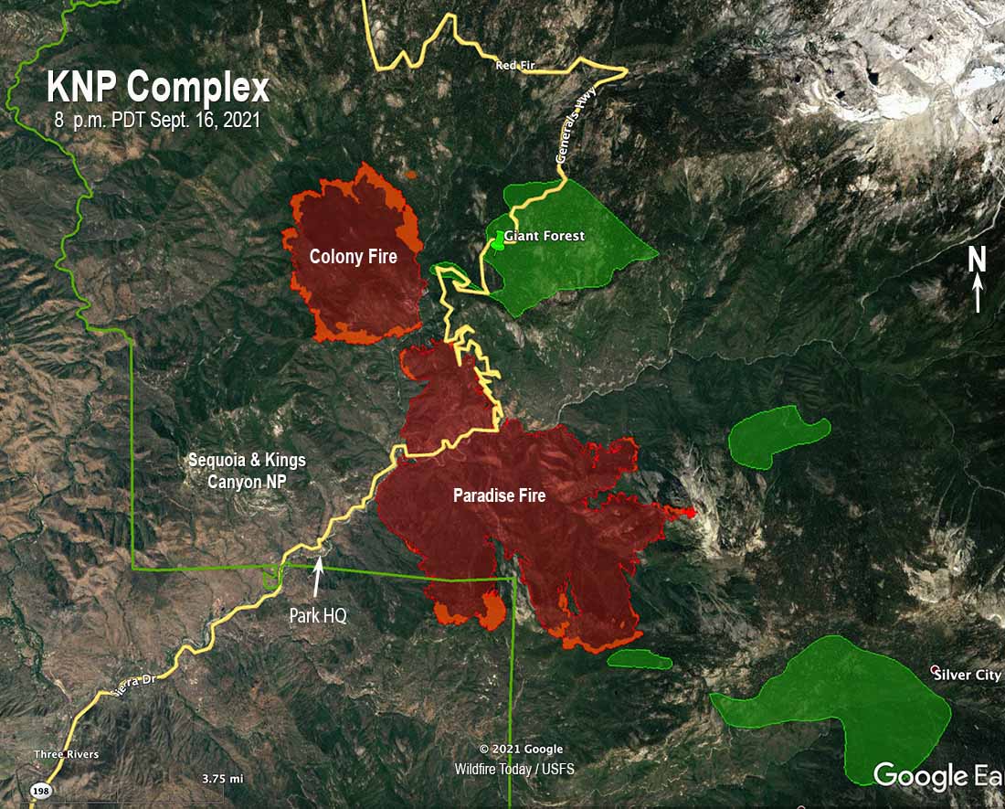
The KNP Complex of fires ignited by lightning on September 9 is growing in all directions in Sequoia National Park in Southern California. The complex is comprised of the Paradise and the Colony Fires. A mapping flight Thursday night found that the combined size of the two, which were about a quarter-mile apart, was approximately 11,300 acres.
To see all of the articles on Wildfire Today about the KNP Complex of fires, including the most recent, click HERE.
North of the Paradise Fire is the Giant Forest, a grove of very large giant sequoias. In this area is the General Sherman, the world’s largest tree measured by volume. It stands 275 feet tall, and is over 36 feet in diameter at the base. The National Park Service has been managing this grove with prescribed fire since the 1960s which will help the monster trees fend off the fire, but the multi-year drought has led to historically low fuel moistures, leading to concern that they could be damaged by these very intense fires.
The Tulare County Sheriff’s Office is maintaining a map showing the areas under evacuation orders.
KNP Complex of fires, map, 8 p.m. PDT Sept. 16, 2021. The bright red areas had intense heat when the fire was mapped. Green represents the approximate location of giant sequoia groves.
On Thursday fire activity picked up in the late afternoon with terrain driven surface spread and short crown fire runs as the smoke cleared, humidity levels dropped, and the temperature increased.
Firefighters from CAL FIRE are building an indirect dozer line southwest of the Paradise Fire outside the National Park, a project that is expected to take several days to complete. It starts at park headquarters near the Ash Mountain Entrance and runs southeast along the toe of Paradise Ridge south of Milk Ranch.
There are multiple large giant sequoia groves and structures southeast of the Paradise Fire that could be threatened, including Atwell Grove, Silver City Resort, and Mineral King Ranger Station.
Resources assigned to the fire include 10 hand crews, 28 engines, and 8 helicopters for a total of 416 personnel.
Protecting the Sequoia National Park sign with structure protection wrap, September 14, 2021. InciWeb.
Will be charged with parole violation, aggravated arson (multiple structures), arson of an inhabited structure, and arson during a state of emergency
3:16 p.m. PDT Sept, 15, 2021
Hopkins Fire, looking southeast from Ridgewood Grade at 3:39 p.m. PDT Sept. 12, 2021.
On Tuesday September 14, the California Department of Forestry and Fire Protection (CAL FIRE) and officers from the Mendocino County Sheriff’s office arrested a person for starting the Hopkins Fire that on Sunday burned numerous structures and 257 acres in Calpella, California.
During a briefing at the Incident Command Post on Tuesday, an officer from the Mendocino County Sheriff’s Office announced the status of the case.
Investigators recovered footage from a security camera at a local business that showed an adult male starting the fire. Tuesday morning one of the investigators saw that person in downtown Calpella who was then contacted and identified as Devin Lamar Johnson, a 20-year old male from Ukiah, California. Mr. Johnson was on probation in Mendocino County for an attempted robbery charge.
After fire investigators and Sheriff’s detectives followed up, Mr. Johnson was arrested and placed in the Mendocino County Jail on a no bail status to be charged for parole violation and three arson charges: aggravated arson (multiple structures), arson of an inhabited structure, and arson during a state of emergency.
Mr. Johnson may have been photographed watching the fire in a photo taken by Peter Armstrong.
Hopkins Fire map. The icons represent heat detected by satellites as late as 4:53 a.m. PDT Sept. 13, 2021.
Update, September 16, 2021: The Press Democrat reported yesterday a damage assessment found that 30 homes and 16 other structures were destroyed in the Hopkins Fire.
The Dixie Fire that started on Tuesday, July 13 has now burned 960,470 acres. Minimal fire activity is occurring but with some increase in visible smoke as the weather continues to become warmer and drier. The incident management team reported that unburned interior islands of vegetation near the line continue to flare up and present control issues due to a limited number of firefighting resources.
Nearly all of the perimeter has established fireline. There are a few relatively small stretches where it does not exist according to the September 14 map prepared by the Incident Management Team. But it is possible that it is not needed in all of those locations.
A satellite overflight at 2:29 a.m. PDT September 14 found few large heat sources. However from hundreds of miles above the Earth the sensors on the satellite can’t detect small heat sources that firefighters on the ground could easily see, or during the later stages of mopup, feel with the back of their hand as they try to extinguish every hot spot within hundreds of feet of the fireline.
Dixie Fire map, northwest side, September 14, 2021.
Park personnel are concerned about threats the fires pose to groves of giant sequoia trees
10:17 a.m. PDT Sept. 15, 2021
KNP Complex of fires 3-D map, 7:05 p.m. PDT Sept. 14, 2021. The green areas are the approximate locations of giant sequoia groves. The white lines were the perimeters Monday night.
The KNP Complex of fires more than doubled in size Tuesday, growing by more than 4,000 acres to bring the combined size of the Paradise and Colony Fires up to 7,039 acres.
The southernmost blaze, Paradise, is now well established on the north side of the Generals Highway and the Middle Fork of the Kaweah River.
To see all of the articles on Wildfire Today about the KNP Complex of fires, including the most recent, click HERE.
There is concern that the giant sequoia trees could be more vulnerable to fire than usual during this drought and the very low fuel moistures. During a Tuesday evening mapping flight the Colony Fire was about a half mile west of the Giant Forest grove but it has to cross the Marble Fork of the Kaweah River to get there. The Paradise Fire was a little over a mile south of the grove.
The incident management team predicts that by the end of the day on Thursday the two fires will have merged at Generals Highway. The Colony fire will likely run uphill in Yuca Creek to the north and uphill to the Giant Forest of sequoias.
KNP Complex of fires map, 7:05 p.m. PDT Sept. 14, 2021. The green areas are the approximate locations of giant sequoia groves. The white lines were the perimeters Monday night.
The weather is not in favor of the firefighters on Wednesday. There is no rain in the forecast and good ventilation will favor fire growth. Afternoon and evening winds of 15 to 25 mph with gusts to 40 mph are expected. A cooling trend will take place beginning Thursday and continue through the weekend.
6:47 p.m. PDT Sept. 14 2021
Tuesday afternoon the KNP Complex of fires, comprised of the Colony and Paradise Fires, was mapped at a total of 5,861 acres.
An Evacuation Order, meaning evacuate now, is in effect for the community of Sycamore within Sequoia & Kings Canyon National Park. Other areas are under a warning that they may have to evacuate. The Tulare County Sheriff’s Office is maintaining a map showing these areas.
In addition to spreading to the north, the Paradise Fire has grown to the south, crossed Paradise Ridge, and is backing down the other side, according to the Deputy Fire Management Officer for the park who participated in a briefing in a community meeting Tuesday evening.
An incident base will be established near Horse Creek Campground and will include a mobile fire retardant plant for helicopters. This is 11 air miles southwest of the Paradise Fire off of Generals Highway.
10:56 a.m. PDT Sept. 14, 2021
KNP Complex of fires 3-D map, looking northeast. The red lines are the perimeter mapped by a fixed wing aircraft at 8:33 p.m. Sept. 13, 2021. The red dots represent heat detected by satellites as late as 3:41 a.m. PDT Sept. 14, 2021.
Two lightning-caused wildfires in Sequoia & Kings Canyon National Park that started September 9 in southern California were very active Monday, more than doubling in size. The KNP Complex is comprised of two fires that were previously separated by the Generals Highway, 198, and the Middle Fork Kaweah River. The Paradise Fire is on the south side and the Colony Fire is on Colony Peak north of the river and the highway.
President Biden visited two locations in the West Monday to gather information about the current wildfire situation. His first stop was in Boise where he became the first US President to visit the National Interagency Fire Center since it was created 50 years ago.
During a tour of NIFC he talked with a group of smokejumpers and the President was seen holding a pulaski fire tool. Later, sitting in front of what looked like shelves of parachutes he met with Idaho Governor Brad Little, George Geissler of the National Association of State Foresters, and Grant Beebe, BLM’s Assistant Director for Fire and Aviation. The President said Senators Ron Wyden and Jeff Merkley intended to be there but their flight was cancelled due to weather.
President Biden at NIFC Sept. 13, 2021.
Mr. Biden praised wildland firefighters for the work they do and reiterated that he is committed to raising their pay. The full text of his public remarks at Boise are below, but here is an excerpt:
The fact is that we’re in a situation where too many memorials are — have been held. And I’ve directed my administration to provide for pay bonuses and incentives to ensure every federal firefighter — because that’s the only authority I have — makes at least $15 an hour. I mean, they should make a hell of a lot — heck of a lot more, but at least $15 an hour. And I’m committing to work with Congress to raise the pay gap for federal wildland firefighters.
And so, you know, believe it or not, there’s massive shortage of fire hoses. I think you all get it. But the idea that we went into this fire season with a shortage of fire hoses — that’s all I heard from my guys back East and in the Midwest: no fire hoses.
Well, fortunately, they thought a long time ago about a thing called the National Defense Act. And what I was able to do — excuse me, the Defense Production Act.
And I was able to restart production of bringing — bringing a lot of people back to work, delivering 21,920 new feet of fire hose in the frontlines, putting a company back to work that was out of business that stopped — stopped manufacturing.
The Associated Press reported Monday that the administration’s use of the Defense Production Act helped an Oklahoma City nonprofit called NewView Oklahoma, which provides the bulk of the U.S. Forest Service’s hose, obtain needed supplies to produce and ship 415 miles of fire hose. If that is correct, two zeros should be added to the 21,920 feet mentioned by the President, making it 2,192,000, which is 415 miles.
President Biden at NIFC Sept. 13, 2021. L to R: Idaho Gov. Brad Little, President Biden, Grant Beebe (BLM).
About two hours after Air Force One landed, it departed for Mather Air Force Base near Sacramento. After landing he visited California’s Office of Emergency Services and received a briefing on the wildfires in the state. At one point a map of the Caldor Fire was displayed on a large screen. The plan was for the President to then take an aerial tour of a fire in El Dorado County, the location of the huge 210,000-acre Caldor Fire. And following that, more public remarks about wildland fire.
President Biden receives briefing about the Caldor and other fires in California after flying to Mather AFB, Sept. 13, 2021.President Biden receives briefing about the Caldor and other fires in California after flying to Mather AFB, Sept. 13, 2021.
Below is the text of the Presidents public remarks while at NIFC September 13, 2021, provided by the White House:
12:08 P.M. MDT
MR. BEEBE: Mr. President, on behalf of the wildland fire community, I’m proud to welcome you to the National Interagency Fire Center — or NIFC, for short. And we always say NIFC is a place, not an organization.
THE PRESIDENT: (Laughs.)
MR. BEEBE: We’re incredibly proud of it.
Thank you for coming. We’re honored you’re the first President to visit in the 50-year history of the Fire Center, and it’s quite an honor.
I’m Grant Beebe. I’m the Bureau of Land Management’s Assistant Director for Fire and Aviation. And speaking for all the NIFC partners, I’d like to thank you particularly for being here and for your genuine and intense interest in wildland fire management.
I just want to point out: This is a coalition of partners. We have a team here. We have National Park Service, DOD, Fish and Wildlife Service, Bureau of Indian Affairs, National Association of State Foresters representing the states, FEMA, U.S. Fire Administration, and, of course, U.S. Forest Service, Fish and Wildlife Service.
I think I got them all; somebody will correct me. Oh, and of course, National Weather Service — one of the original partners here at NIFC. The inception of this was a Forest Service, BLM, NOAA, Fish and Wi- — National Weather Service operation.
So, we’re incredibly proud of it. We’re so proud to have you here.
NIFC was created 50 years ago, and it is the original and durable model for interagency, intergovernmental coordination. Extremely lengthy, intense, and damaging fire seasons like the one we’re experiencing now reinforce the purpose of places like this.
Through the hard work, ingenuity, and persistence of generations of fire professionals, wildfire response across the nation is unified, cooperative, and professional. And I’ll say that we all stand on the shoulders of giants. We inherited this place, and we’re trying to keep it going.
In wildland fire, there’s no one community, agency, Tribal organization that has enough resources to manage all of its fires. Fires don’t know jurisdictional boundaries, and we try to ignore jurisdictional boundaries ourselves. One of our speakers will speak to that particularly.
But the kind of fires we’re experiencing these days — the kind of long-duration, massive, destructive fires we’ve witnessed in recent years in places like California, Oregon, Washington, Colorado, and, unfortunately, for Governor Otter [sic] this year, in Idaho — they’re teaching us that we need to maybe change the way we’re doing business.
Hopkins Fire map. The icons represent heat detected by satellites as late as 4:53 a.m. PDT Sept. 13, 2021.
Multiple homes burned Sunday in the Mendocino County community of Capella Sunday afternoon in Northern California. Capella is on the Redwood Highway between Redwood Valley and Ukiah west of Lake Mendocino.
The fire was reported on the west side of Eastside Cappella Road off Hopkins Street at 2:01 p.m. Sunday. It was pushed by a 20 mph wind while the relative humidity was in the low 20s and ran east to the shore of Lake Mendocino, a distance of about a mile.
Hopkins Fire, looking southeast from Ridgewood Grade at 3:39 p.m. PDT Sept. 12, 2021.
Matt LaFever, a reporter for Redheaded Blackbelt, said he saw at least 20 structures in flames. Photographer Kent Porter with the Santa Rosa Press Democrat recorded video of a neighborhood that was destroyed on Eastside Calpella Road.
Firefighters were able to start getting containment of the fire after it got to Lake Mendocino. The photo below taken Monday at 7:57 a.m. shows a small amount of smoke that had settled near the ground. CAL FIRE reported that the Hopkins Fire burned 257 acres.
Smoke from the Hopkins Fire settles near the ground, as seen from the Redwood Valley camera, looking south at 7:57 a.m. Sept. 13, 2021.