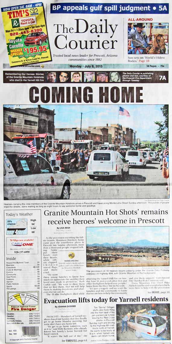
This is the front page of Prescott’s newspaper, the Daily Courier today, Monday, July 8 — the day after the bodies of the 19 firefighters were escorted from Phoenix to Prescott, and the day before the scheduled memorial service on Tuesday.
News and opinion about wildland fire
This is the front page of Prescott’s newspaper, the Daily Courier today, Monday, July 8 — the day after the bodies of the 19 firefighters were escorted from Phoenix to Prescott, and the day before the scheduled memorial service on Tuesday.

(UPDATE July 15, 2013)
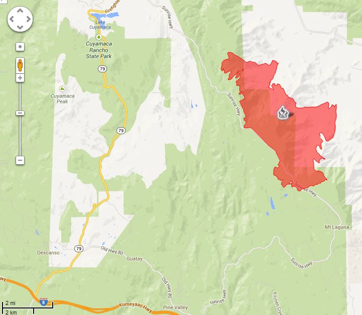
The Chariot fire is listed at 100 percent contained, so the map below could be the final one. A zoomable map is available HERE.
****
(UPDATE at 9:15 a.m. PDT July 10, 2013)
The Chariot Fire not only burned a landmark-type lodge on Mt. Laguna east of San Diego, it also destroyed 120 structures, according to CAL FIRE, the agency attempting to suppress the fire. Initial reports by the San Diego Union that the lodge at the Sierra Club’s facility across the highway was destroyed were incorrect, but at least one structure there did burn.
Most of the structures, including the lodge built in 1925, were in the Al Bahr Shrine Camp a mile north of the US Forest Service’s Laguna Engine Station and about two miles north of the post office in the small community.
The fire started Saturday afternoon near the Butterfield Ranch in the Anza-Borrego Desert, 3.000 vertical feet below the community. Most of the damage was done Monday afternoon. CAL FIRE reports the fire has burned 7,055 acres and is 40 percent contained. The only map provided by CAL FIRE is dated July 8 and does not show the fire’s presence on Mt. Laguna.
Shriners International contributes funding to children’s hospitals, but most people know them as the organization that drives tiny cars performing maneuvers in parades.
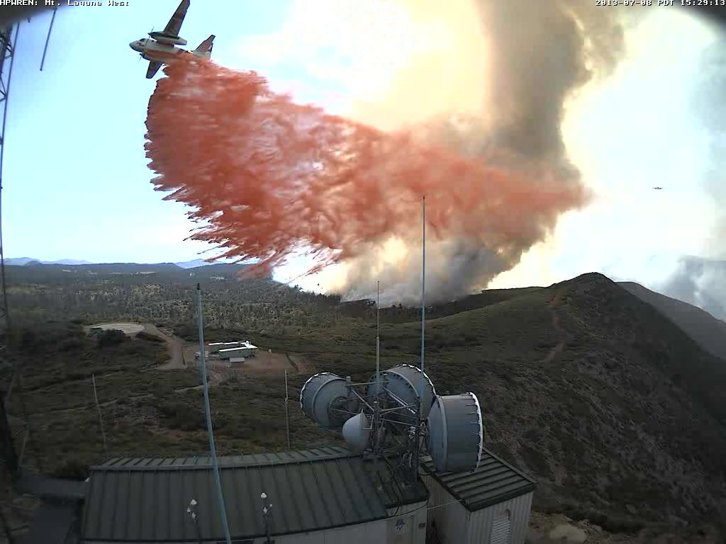
The web cameras operated by the University of California’s High Performance Wireless Research and Education Network (HPWREN) captured the aerial fire fight as air tankers dropped retardant to protect the electronic sites, including their own, on Mt. Laguna at the former Air Force base.
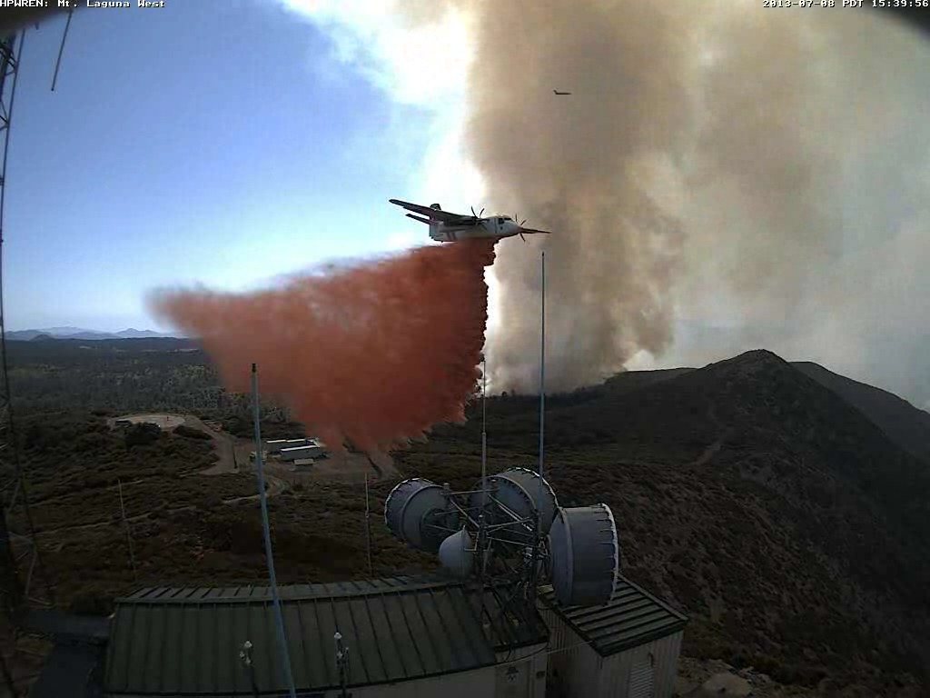
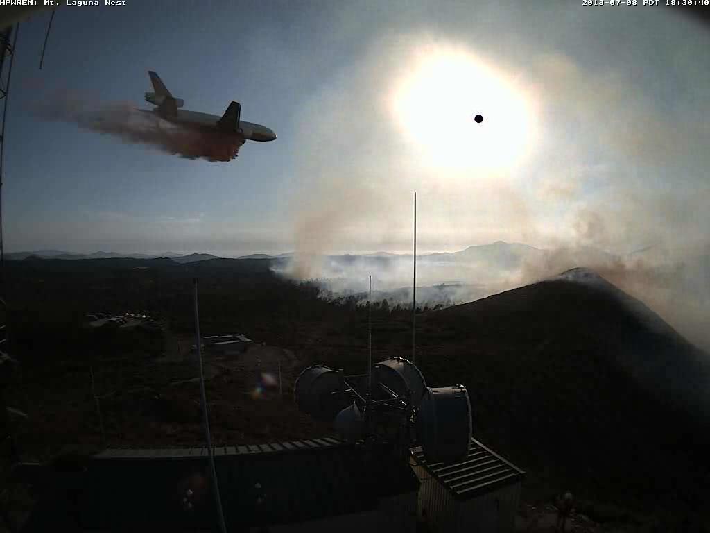
Thanks go out to the Lone Ranger for pointing out the HPWREN site that has 14 other photos of the air tankers working on Mt. Laguna.
****
(UPDATE at 11:18 p.m. PDT, July 8, 2013)
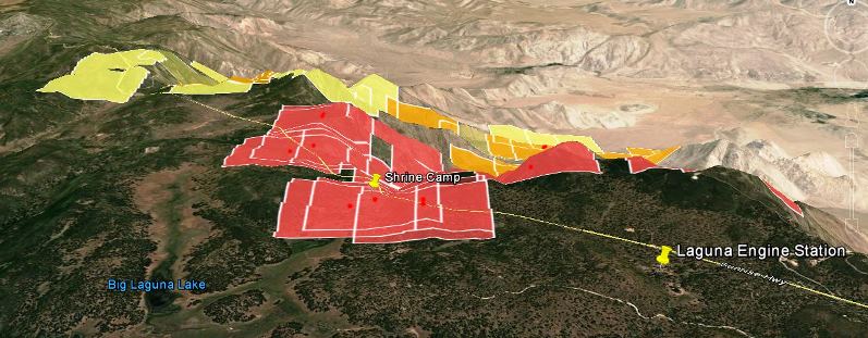
The San Diego Union is reporting that the Chariot Fire not only made it to the top of the slope, from the desert 3,000 vertical feet up to the Mt. Laguna area, but it crossed the Sunrise Highway and burned into the Cleveland National Forest. And, most importantly, it burned two landmark-type buildings on special use permits in the Forest — the large and very old lodges at the Sierra Club and the Al Bahr Shrine Camp on opposite sides of the highway, plus about six other buildings.
The fire crossed the Sunrise Highway and burned into at least one of the group campgrounds in the Laguna Campground complex adjacent to the Shrine Camp. A fire spokesperson said 120 residences were evacuated. The fire is burning about a mile north of the Laguna (or Camp Ole) engine station… one of my old stations on the Cleveland National Forest.
CAL FIRE reports the fire has burned 4,700 acres and is being fought by 1,383 personnel. It is about 50 miles east of San Diego.
The San Diego Union also reported, (incorrectly) “Loud booms could be heard as trees caught fire and their tops exploded.” The old “exploding trees” myth lives on.
****
(UPDATE at 3:42 p.m. PDT, July 8, 2013)
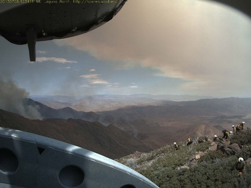
Kelly found this photo on the Mt. Laguna web cam that shows a crew in the foreground.
****
(Originally published at 7:12 a.m. PDT, July 8, 2013)
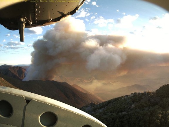
The Chariot Fire north of Mt. Laguna, California that is causing evacuations on the mountain can be watched in near-real time thanks to a web camera at the old Air Force Base at Mt. Laguna. The photo above was taken at 6:10 a.m. on Monday — the one below at 11:58 a.m. Sunday. Several campgrounds as well as the Al Bahr Shrine Camp have been evacuated.
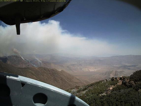
CAL FIRE said at 7:15 Sunday night the fire had burned 2,500 acres. The fire is burning on the desert slopes below Mt. Laguna, my old stomping grounds. There is a difference in elevation of about 3,000 feet from the desert floor to the forested area at the top. In the last 10 years or so there have been several fires in this general area so it is possible that it will burn into one or more of those and slow down considerably.
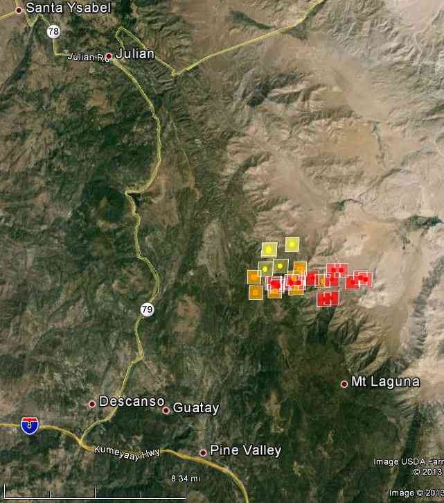
The map of the Chariot Fire above shows heat detected by a satellite at 2:20 a.m. Monday.
The San Diego Union has some photos of firefighters from the U.S. Forest Service’s Descanso Engine Crew watching the fire from the top of the hill. The slopes below are far too steep on which to attack a rapidly moving fire.
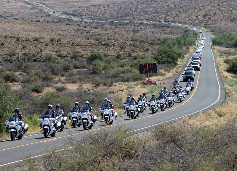
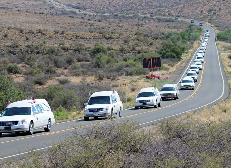
The 19 members of the Granite Mountain Hotshots that died on the Yarnell Hill Fire June 30 were escorted back to Prescott today, closer to their home base. They were moved from the medical examiner’s office in Phoenix to the medical examiner’s office in Prescott, a distance of approximately 100 miles. A helicopter was circling overhead. The first part of the ground escort was about 20 officers on motorcycles.
These first three photos were taken on Highway 89 five miles north of Yarnell, Arizona.
A few vehicles after the bikes was a Granite Mountain Hotshots’ crew carrier.
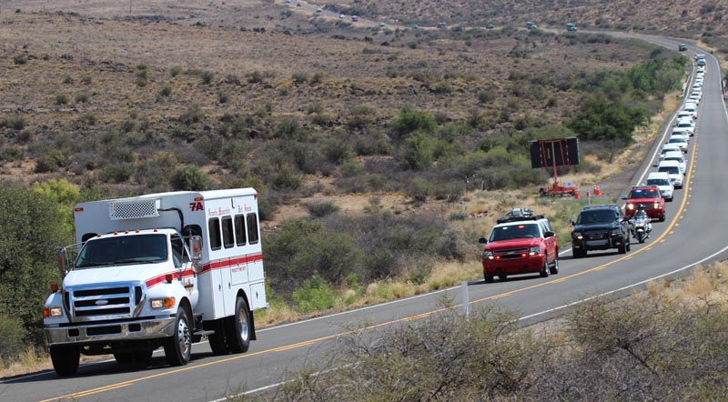
And then the 19 hearses, each with a sign in the window identifying the Hotshot inside.
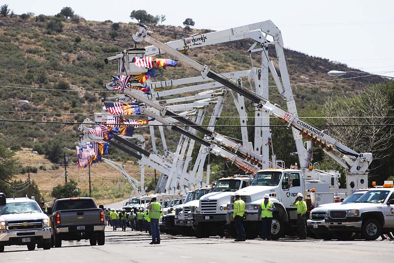
A memorial service for the Granite Mountain 19 will be held in Prescott Tuesday. We will remain in the area reporting on this historic event.
The first three photos were taken by Bill Gabbert.
With the recent deaths of 19 firefighters on the Yarnell Hill Fire, we must remember the deaths of 14 firefighters 19 years ago on the South Canyon fire near Glenwood Springs, Colorado.
On the afternoon of July 6, 1994 the fire spotted across the drainage and beneath firefighters, moving onto steep slopes and into dense, highly flammable Gambel oak. Within seconds, a wall of flame raced up the hill toward the firefighters on the west flank fireline. Failing to outrun the flames, 12 firefighters perished. Two helitack crew members on top of the ridge also died when they tried to outrun the fire to the northwest. The remaining 35 firefighters survived by escaping out the east drainage or by seeking a safety area and deploying their fire shelters. More info here.
The firefighters who lost their lives that day:
If you are over 40 years old, do you remember where you were when you heard about the 14 deaths? I heard about it on a phone call from Steve Creech, the Fire Coordinator for the State of Indiana. After I hung up I thought that can’t be true. In this day and age, we no longer have large groups of firefighters being killed at the same time. We’ve grown and learned beyond that, I told myself, refusing to believe it.
And this past Sunday, I had the same feeling — 19 firefighters dead? That can’t be true. But fark, we have not grown and learned beyond that. We are still fighting fire with sharpened pieces of metal attached to the ends of sticks, under, in many cases, aircraft built for the Korean War. We still put wet stuff on the red stuff. And… dammit, we can still lose 95 percent of a hotshot crew in a matter of minutes… in 2013.
I hope we don’t passively resign ourselves, thinking that this is inevitable.
Dammit guys and gals…. Let’s Be Careful Out There.
(UPDATE at 9:14 p.m. MDT, July 6, 2013)
We added this photo of the entrapment site on the Yarnell Hill Fire. The dozer line was punched in after the incident to facilitate the removal of the bodies, which were at the end of the line. The photo was taken by Wade Ward of the Prescott FD, and is used here with permission.
****
(Originally published at 8:53 MDT, July 6, 2013)
Robert Ford, who grew up in Prescott, studied some of the information that is available about the wind when the 19 members of the Granite Mountain Hotshots were killed on the Yarnell Fire June 30. His message is below, with a few notes from me [in brackets].
****
“A graphic showing the “safety zone” and shelter deployment site is here.”
[Note from Bill: the times in that article are approximately 6 hours in error. We were told by Carrie Dennett of the Arizona State Forestry Division that their office received notice that shelters had been deployed at 4:47 local time, Mountain STANDARD Time. But they were not in direct communication with firefighters. The information had to travel up a chain of command and may have been delayed. I have not seen definitive word on when the deployment took place.]
“A Google Earth rough approximation of the high res photo above is attached.
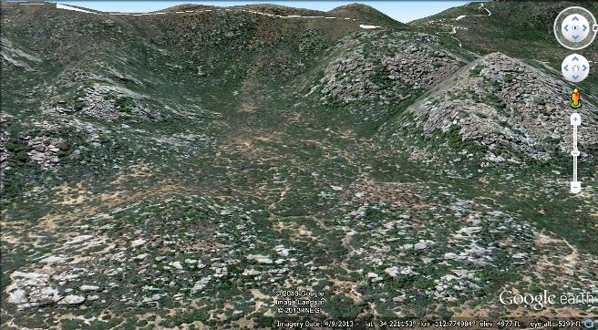
Looking due west, eye altitude about 5400 feet. The approx. shelter site is 34.221416,-112.775796. The Landsat imagery was acquired last May; note the fuel, when compared to the Facebook photo above.
If you have Google Earth, it is also easy to duplicate the camera location of the time-lapse video (posted on your site) [embedded again above] purportedly shot from “Congress”; actually I’ve determined it was shot just west of the Date Creek Road (dirt – you can see the dust clouds from passing vehicles) just North of the intersection with Highway 89. The time-lapse video, looking N45E, shows the fire just cresting the ridge starting about one mile due Northwest of the shelter deployment site, then flashing to the right (southeast) along the ridge-line towards the deploy site. The smoke then obscures how the fire must have flashed over the ridge just 1500 feet west of the deploy site. In any event, the video shows how very rapidly the wind moved through the natural basin of the deploy site; probably aided by a natural venturi effect from the walls of the basin; also note that by the end of the video a trailing vortice formed off the ridge crest has actually moved the plume locally down (by 2000 feet !) to about the elevation of the Camera. It was an amphitheater of death for all of those brave men. This also explains why some men were found “outside” their shelters; that’s because a wind of unimaginable proportion, moving locally upward, lifted their shelters away.
Well thank you and you are very welcome to use whatever of this information you please. I have learned so very much from your site; it contains absolutely the best no-nonsense web coverage of this fire. In the event you wondered, I used to model the effects of wind on the topography surrounding astronomical observatories; but I never had to deal with a surface boundary condition as defined by a wildfire: that adds an order of magnitude of complexity to the simulation. I would like to presume the Feds will realize the importance of contracting a surface topography wind effect model for this fire, as a component of their investigation; If you have any say in the matter I am happy to recommend the best people; it’s not cheap as it requires supercomputer time.
Finally, I needed to relate that I grew up in Prescott; fighting fires was a rite of passage. You would have thought that by now the FS would have developed a weather-topography-fuel load model to deal with this sort of thing.
Well now they will do so.”
****
In a follow-up message, Mr. Ford wrote:
****
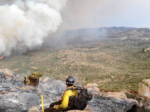
“For your information, I was able to determine the approximate vantage point of the photo [added above] as looking due East from 34.227291,-112.788630, at an eye elevation of 5,510 feet.
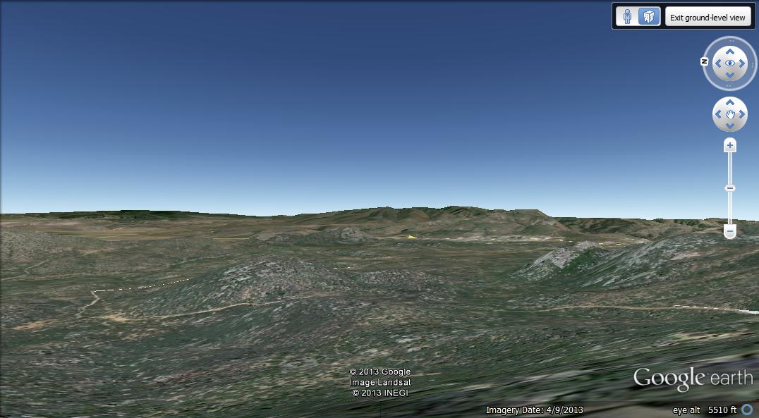
This location [above] is just off (east of) the trail on the ridge crest-line, and is located about 0.82 miles Northwest (as the crow flies; longer by trail) of the shelter deploy site (subject of my previous post). Now given the vantage point vector as due East, the plume appears to be moving southeast; thus the fire front (barely visible in the photo) is being driven directly towards Glen ilah.”
****
Follow-up from Bill:
A comment left on one of our posts by “lone ranger” found an article that included information provided by the National Fire Administration, which is the first I’ve head that they had anything to do with this incident. I would be hesitant to trust this information. The report says the firefighters initially took refuge in a burned area, the black, then left that site and deployed their fire shelters later in another area as they headed toward a ranch which was to be their safety zone.
There continues to be confusion about the times. This may be partly due to the fact that Arizona is not on Daylight Savings Time like most of the United States. They use Mountain STANDARD Time.
A blog called Cliff Mass posted a very clear and detailed explanation of the weather. His last line in the article:
A number of media outlets called the strong winds unpredictable and random. This is not correct, as shown by the information I provided above.
Chuck Bushey told us that once upon a time there were:
…Fire Behavior Service Centers in various regions, warning crews in real time about t-storms (or other events) heading their direction that they couldn’t yet see and getting them into the black. The Southwest use to run a FBSC with a qualified Fire Behavior Analyst (FBAN) but I think they dropped it as did everyone else.
Updates on the fatalities of the Granite Mountain 19
We have more information about the deaths of the 19 firefighters (including new information about the last moments of the Granite Mountain Hotshots), the weather that appeared to be a factor in the tragedy, as well as updates about the Yarnell Hill Fire where the accident occurred.
The White House has announced that Vice President Biden will attend the memorial service for the firefighters.
Wildfires in eastern Russia
From InSerbia:
The Far Eastern Federal District forestry department reported on Friday that almost 20 wildfires broke out in the Russian Far East on Thursday, majority of them in Yakutia.
“There were 16 wildfires in Yakutia, two in the Khabarovsk territory and one in Kamchatka,” the report said.
Four wildefires in Yakutia have been put out. However, 15 forest fires are still raging in the Russian Far East.
The fires spread over approximately 170 ha of forest in Kamchatka. In Yakutia, about 90 ha of forest were burned, in the Khabarovsk about 3 ha.
More than 730 firemen, 42 fire trucks, 7 planes and 6 helicopters are assigned to firefighting mission.
Some residents upset with insurance company
Some homeowners are upset that an insurance company is asking them to take some personal responsibility to reduce the wildfire risk on their property.
Below is an excerpt from an article in the Colorado Springs Gazette by Bill Vogrin:
…I reported that on June 10, State Farm mailed 12,000 letters to homeowners in red zones in six Western states alerting them that inspectors would be visiting their properties and taking photos to assess their risk from wildfire.
In the column, State Farm spokeswoman Angela Thorpe said the largest property and casualty insurer in the country was dusting off its dormant “wildfire loss prevention program” after the industry experienced massive claims following devastating wildfires across the West in 2012.