Cohesive Strategy Workshop registration opens

COHESIVE STRATEGY WORKSHOP

In 2017 the first Cohesive Strategy Workshop in Reno, Nevada featured the theme of All Hands All Lands: Implementation Rooted in Science. It focused on the Cohesive Strategy — what it meant then and what early success looked like. Presentations and discussions emphasized the role of science in supporting the Cohesive Strategy and identified processes to ensure the integration of science in all planning for wildland fire management.

The Cohesive Strategy stands as the framework by which all stakeholders can address barriers and identify solutions for complex wildland fire issues.

The Cohesive Strategy Addendum Update [PDF] was released earlier this year and examines critical emphasis areas and implementation challenges that either were not addressed then or have surfaced in the 10 years since the original Cohesive Strategy framework.

This workshop will gather the collective voice of attendees to identify solutions and the issues that keep us from implementing the Cohesive Strategy at scale. The Wildland Fire Leadership Council (WFLC) will pursue these actions after the Workshop to help overcome identified barriers and support implementation of the Cohesive Strategy.

Registration for the 2024 Workshop in Atlantic City includes:

        • All on-site presentations and discussion, plus refreshments. There will be no virtual presentations.
        • Access to all workshop sessions (for full registration) or the session(s) you attend (for 1 or 2 days of registration).

Field Tour:  New Jersey Pine Barrens

Wednesday, September 18 from 8:00 a.m. to 3:30 p.m.
Field tour, transportation, and lunch included in your registration fee.

Pinelands Alliance
   PinelandsAlliance.org

The New Jersey Pine Barrens field tour will highlight the cooperation of multiple agencies in New Jersey to support goals and themes of the Cohesive Strategy. The tour includes stops at Batsto Historic Village, the U.S. Forest Service Silas Little Experimental Forest, New Jersey Forest Fire Service Coyle Field Airbase, and the Roosevelt City Fire-Adapted Community and firebreak project.

Special IAWF Member and Student rates are available.
Early-bird discounts for full workshop registrations before August 15.

Cohesive Strategy workshop registration fees

⏩  Register here  ⏪ 

Scholarships available:

IAWF offers need-based travel and registration scholarships to attend the workshop, to provide opportunity for those who may not be able to attend because of the cost. We hope to increase participation of underrepresented communities and geographic areas for networking and peer learning.

Applications will be accepted continuously until the workshop; we will begin reviewing applications and making awards on June 15. It includes free registration and/or $500 USD for travel expenses.
⏩  Submit a scholarship application  ⏪

If you are selected, we will email your instructions on registering for the workshop, and you will receive travel reimbursement when you arrive at the workshop.

Questions about the workshop or
about registration?  CONTACT MIKEL:

workshop info


Workshop registration is
available online [HERE].


Frank Carroll stirs up Lake Tahoe

“The Forest Service has no authority to let fires burn millions of acres — misappropriating tax dollars and recklessly destroying our natural resources. It’s an inverse condemnation of private property and wanton destruction of public resources, pure and simple.” ~ Frank Carroll

Agitator Frank Carroll, whom Dana Tibbitts with the Nevada Globe refers to as a “Chief Forester,” is an active part of this “discussion” in the Tahoe Basin and in New Mexico and other states, advising forest owners who hire him and assisting people in suing the Forest Service over losses resulting from escaped prescribed fires or managed fires that burned more acreage than Carroll thinks they should have. In her report, Tibbitts quotes anonymous sources to claim that FS Chief Randy Moore’s “Burn Back Better” letter (the annual fire-related “letter of intent”) has “caused a firestorm among firefighters and Forest Service veterans nationwide.”

Some of Tibbitts’ anonymous sources are associated with the “National Wildfire Institute,” founded by Bruce Courtright (retired FS Deputy Chief for Management Improvement) and Michael Rains — who at one time directed the USFS Forest Products Lab. Char Miller in the Los Angeles Times refers to the group as “a suppression-friendly bloc of retired Forest Service officials,” but they don’t seem to have a website or any publicly visible managers or founders besides Rains and Courtright.

Some other more widely respected retired fire experts disagree, and they’ve written here before on this topic, citing the founder of the U.S. Forest Service Gifford Pinchot. “The debate within the agency defies permanent resolution,” writes Char Miller,”not least because deference to political exigencies is baked into the Forest Service’s DNA. For that, we can thank, or blame, Pinchot.”

Miller is a senior fellow of the Pinchot Institute for Conservation, and a fellow with the Forest History Society. “In an 1899 article in National Geographic,” he explains, “Pinchot clearly detailed wildfire’s essential role in regenerating forests in the South and mountainous West. But despite this robust ecological evidence, it would be fire’s bad optics that drove his pitch for establishing the Forest Service.” As per the agency’s first manual: “Probably the greatest single benefit derived by the community and the nation from forest reserves is insurance against destruction of property, timber resources, and water supply by fire.”

Opinion: The burning debate — manage forest fires or suppress them?

Carroll and his cohorts, though, claim that the USFS “just gave firefighters license to burn millions of acres of forest and rangelands with zero commitment to putting the fires out.”

Tahoe-Douglas Fire Chief and head of the Northern Nevada Fire Chiefs Association Scott Lindgren said, “The latest forecast and guidance from the Chief is so unhinged from firefighting realities on the ground as to defy rational analysis or practical guidance.”

“It’s caused a firestorm among firefighters and Forest Service veterans nationwide.”  ~ Dana Tibbitts

Fire Chief Scott Lindgren, Tahoe Douglas Fire Protection District

According to Tibbitts and the Nevada Globe, USFS Regional Foresters are supposedly enacting a new policy now, calling for all fires in the Tahoe Basin to be risk-assessed and monitored by those same Regional Foresters, “who alone would determine the appropriate response to new fire ignitions.”

Chief Lindgren says allowing fires to burn is criminal and claims that allowing fires to burn means the USFS can count those acres as “treated” in burn quotas ordained by administrators in Washington DC. “These are not treated acres,” he says, “they are destroyed acres!”

Frank Carroll says USFS fire commanders and administrators are using firefighter safety as a false flag to justify wildfire use, even at the expense of civilian lives and devastated communities.

“Firefighter safety is an excuse that is neither safe nor supportable — a feature of the persistent failure to build informed consent and to analyze environmental impacts before letting wildfires burn and then expand them on purpose,” Carroll said. “They’re unilaterally implementing giant prescribed wildfires — consequences be damned.”

According to the anti-managed-fire crowd, the Biden-Harris administration’s plan to Burn Back Better is detailed in Confronting the Wildfire Crisis and lays out a 10-year program to treat 20 million acres of National Forest System lands and 30 million acres of other federal, state, tribal, and private lands. Randy Moore Letter of Intent 04/24/24

Randy Moore Letter of Intent 04/24/24 — click to read

White Mountains fire in New Mexico closes wilderness trails

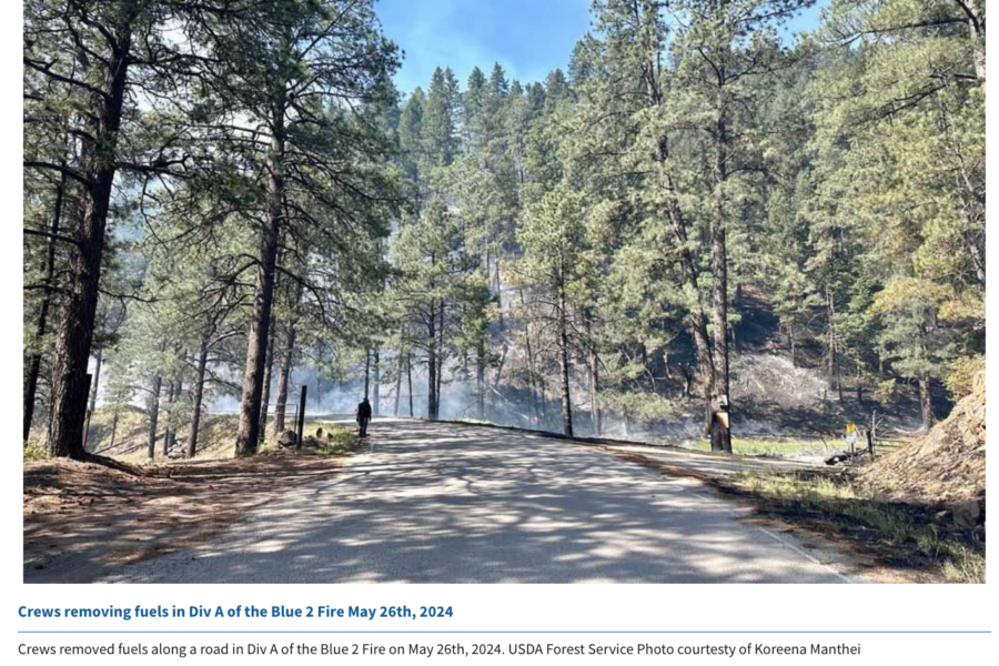
The Lincoln National Forest has issued closure orders for several trails within the White Mountain Wilderness Area on the Smokey Bear Ranger District, and air resources are actively working the 7,200-acre Blue 2 Fire today. The fire has produced more smoke and is still active, even at night, because of high temperatures and dry conditions.

Blue 2 Fire
Blue 2 Fire

The western boundary of the restricted area is at the junction of Forest Service Road 107 and Big Bonito trail #36 and the order is intended to protect firefighters and the public on the Blue 2 Fire. The lightning-caused fire’s just a few miles north of Ruidoso and is still at zero containment, burning in timber and understory with 10 crews and 32 engines assigned. Other resources include 6 helicopters, 6 dozers, and 5 watertenders.

smoke map Ruidoso

According to Ruidoso News, crews are using direct tactics to build line, while aircraft are dropping water and retardant along the firelines. Fire managers are using a feller-buncher in the Ski Run Road area and crews are setting up sprinklers and hoses around local homes for structure protection.

Blue 2 Fire map
Blue 2 Fire map — click for larger version

Updates are available on the inciweb site, and Lincoln County also has updates online.

Spruce Creek Fire burning near Haycamp, Colorado

Spruce Creek Fire from the lookout 05/20 -- ©2024 Rick Freimuth
Spruce Creek Fire from the lookout 05/20 — ©2024 Rick Freimuth

The Spruce Creek Fire took off on May 14 and is burning on  the San Juan National Forest northeast of Dolores, Colorado. The fire’s inside a network of FS roads within an established RxFire burn unit.

Two hotshot crews, two wildland fire modules, and an engine and crew are staffing the fire, along with a Type 3 incident management team.

Lightning ignited the fire Tuesday, and it had burned about 10 acres northeast of Dolores on the Haycamp Mesa by yesterday evening, according to The Journal.

Last month the Dolores Ranger District announced plans to burn 4,577 acres across Haycamp Mesa, and the lightning strike gave them a good start on the fuels reduction project.

Pat Seekins, prescribed fire and fuels program manager for the San Juan, said it’s thus far a low-intensity surface fire, and it’s doing exactly what they need it to do for fuels management in the area. Crews have prepped about 5600 acres. [As of 05/21 the fire’s estimated at 1640 acres; yesterday firefighters used a couple of drones in aerial ignition.]

Spruce Creek Fire on the San Juan
The Spruce Creek Fire is burning northeast of Dolores on the San Juan National Forest. Crews are using existing roads as containment lines, and hope to continue the 10-acre fire next week into the planned 4500-acre prescribed burn. San Juan National Forest photo

The Durango Herald reported that firing operations should begin Tuesday under the management of a Type 3 IMT and should wrap up by Friday. “This is a great opportunity to further reduce the long-term fire risk in this area,” added Seekins. “It’s early in the fire year and we have the resources available, in terms of engines, hand crews, and helicopters, that will help us keep the fire within pre-identified boundaries.”

map - San Juan National Forest
San Juan National Forest map

The ponderosa and aspen forest with gambel oak understory has a natural cycle of burning every 10 to 15 years. The Haycamp Mesa, though, has not seen fire in at least 40 years, according to Seekins; he said it’s had very little fire history and really needs fire in there.

Gambel oak in Colorado has a history in the records of dangerous fires.

1994 South Canyon Gambel oak
July 6, 1994 – Gambel oak on the South Canyon Fire – Storm King Mountain, Colorado

Vegetation on the 1994 South Canyon Fire consisted primarily of Gambel oak, which was more than 50 years old and did not contain much dead material.

It formed a dense, green, continuous closed canopy, 6 to 12 feet tall and appeared to be unaffected by spring frosts.

Visibility within the stand was limited. The surface fuels beneath the canopy consisted of a 3 to 6 inch layer of leaf litter.

The Spruce Creek Fire started in an area that local fire and resource managers have studied for years, according to Dolores District Ranger Nick Mustoe. He says fire managers are securing indirect boundaries along natural features and existing roads to take advantage of favorable weather conditions for managing the fire.

Burning along the northern perimeter 05/20/24 -- IMT photo
Burning along the northern perimeter 05/20/24 — IMT photo

The strategy of using naturally occurring wildfires for hazardous fuels reduction – a policy that officials refer to as “indirect containment,” as opposed to the more derogatory and incendiary “let it burn” label that detractors have coined – is relatively new in practice on the San Juan, which would need at least 30,000 acres burned annually to catch up with the historic natural fire cycle.

Spruce Creek Fire from the lookout 05/20 -- ©2024 Rick Freimuth
Spruce Creek Fire from the lookout 05/20 — ©2024 Rick Freimuth

Smoke will be visible to travelers along Colorado Hwy. 184 between Mancos and Dolores, and to residents of Montezuma County throughout next week. Updates will be posted on Inciweb.

Western wildfire camera detection network

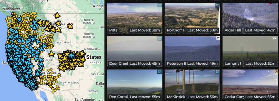
The Oregon Hazards Lab has developed and operates a high-speed camera network that gives fire managers new ways to detect and track wildfires. Cameras are installed atop high peaks or even high-rise buildings with 360-degree views of the surrounding area. Each camera can zoom, rotate, and tilt, allowing users to monitor the landscape, smokes, fire behavior, and weather conditions in real-time, or review later through time-lapse footage. The Oregon camera network is integrated with those operated by collaborators including the University of Nevada in Reno and the University of California at San Diego, with dozens of cameras in Oregon and thousands in the Western states.

The Oregon Hazards Lab network at the University of Oregon has helped put together the largest public-facing camera system in the world.

Doug Toomey, the lab’s director, says, “The cameras are visible during the day, and you can see twenty to forty miles on a clear day. At night they go near infrared, and you can actually see much farther.”

He told KEZI that detecting smoke on the cameras is only the first step. “There’s an operations center where they’re alerted when this camera spots something.”

There are currently 45 wildfire cameras in Oregon, and the Lab plans to operate 75 across the state by late 2025.  These cameras help fire managers:

        • Detect, locate, and confirm ignitions
        • Quickly scale resources up or down
        • Monitor fire behavior from ignition to containment
        • Improve local evacuations and situational awareness

The increased situational awareness available with the cameras means fire managers can confirm 911 calls by reviewing camera footage instead of dispatching personnel or aircraft for reconnaissance. Not only is this safer and less expensive, but it frees up resources that may be needed elsewhere. Fire managers can also monitor prescribed fires, and utility companies can monitor their resources during red flag conditions.

Diane Braun, a former hotshot, said she thinks the cameras would have been a valuable resource when she was on the fireline. “It would have changed the industry,” she says, “from start to finish.” Toomey adds that the cameras play a role before a fire even starts; he says the cameras help to evaluate fuels and weather conditions in the area, including winds, humidity, and other factors before fire crews even arrive.

ALERTWest cameras live feed

The network lets people monitor cameras online. Toomey said he thinks the system can help people watch fire conditions and understand the threats — and even take steps in wildfire prevention. Agencies including the Oregon Department of Forestry have access to the camera system. Jessica Neujahr with ODF said using the cameras helps them not only detect smoke, but also dispatch resources faster and get a preview of the landscape they’re heading into.

==>  WATCH LIVE CAMERA FEEDS HERE  <==

The detection cameras are powered by ALERTWest, a technology platform from DigitalPath. This platform uses artificial intelligence to enable rapid wildfire detection. AI technology pulls the camera feeds from cloud servers and scans images for ignitions using detection algorithms and then can alert dispatch centers. Dispatchers then confirm the detection before alerting responding agencies. Fire managers in Oregon will begin receiving the automated alerts during the 2024 season.

Oregon State research team pursuing “burn to learn”

Fire science researchers at Oregon State University launched  a new project on May 10 to study how embers from homes and other buildings spread to nearby structures. “Our motto is burn to learn,” said OSU full-time research assistant Adarsh Verma. “So we are burning stuff to learn more about fire and how it’s going to spread.”

From May 10 to 16, the research team will burn outbuildings in a field and  examine the effects that structures of different sizes have on the firebrands — the embers and coals produced by a fire. They’ll analyze the numbers of embers produced, the distances they’re lofted on the breeze, and embers’ potential for new starts on adjacent buildings or other fuels.

OSU sheds for burning
OSU sheds slated for burning — photo from video ©Albert James / KEZI

Research assistant Jonathan Carter told Albert James with KEZI-TV that researchers are tracking the number of embers generated by flames and how hot embers get. Firebrands must hit a minimum temperature before ignition occurs in adjacent fuels.

Undergraduate research assistant Jonathan Carter and research faculty member Deepak Sharma on the faculty carry a water barrel at the test site.
Undergraduate research assistant Jonathan Carter and research faculty member Deepak Sharma on the faculty carry a water barrel at the test site. Photo from video ©Albert James / KEZI
Burning shed close
Flames rip through the 6-foot shed. Photo from video ©Albert James / KEZI.
The project kicked off on Friday, and the research team members hope to learn from the experience for future planning. “As we increase the size of the structure, the number of embers and their spread will increase,” Sharma said. “They will spread over larger areas and the number of firebrands will increase.” He said their results could guide structure design in residential areas. He hopes to look into additional factors that could affect fire behavior, including wind and home building materials.

The KEZI broadcast with Albert’s video is online [HERE].

Fire science researchers at Oregon State University launched  a new project on May 10 to study how embers from homes and other buildings spread to nearby structures. “Our motto is burn to learn,” said OSU full-time research assistant Adarsh Verma. “So we are burning stuff to learn more about fire and how it’s going to spread.”