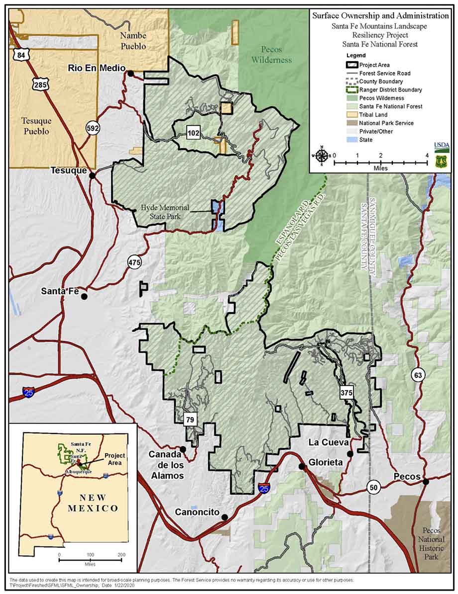
Map of the Santa Fe Mountains Landscape Resiliency Project.
The Board of County Commissioners of Santa Fe County in New Mexico passed a resolution Tuesday urging the U.S. Forest Service and the Santa Fe National Forest to conduct a full Environmental Impact Statement (EIS) for a planned very large fuel management project.
The 50,566-acre Santa Fe Mountains Landscape Resiliency Project would involve prescribed fire and vegetation thinning treatments on 36,680 acres to improve ecosystem resilience by reducing stand density, stand continuity, and stand homogeneity and increase a diverse forest structure at a landscape scale. At least 750 acres would be treated each year with manual or mechanical vegetation thinning and no more than 4,000 acres per year would be treated by the use of prescribed fire during a 15- to 20-year project time frame.
The Forest Service went through the much less complicated Environmental Assessment (EA) process, which included the draft EA, public outreach, and accepting comments, then issued the Finding of No Significant Impact (FONSI) which they feel enables the implementation of the project.
But after three prescribed burning projects on the Santa Fe National Forest got out of control since 2018 and had to be converted to wildfires, some of the locals are worried about future projects on the forest.
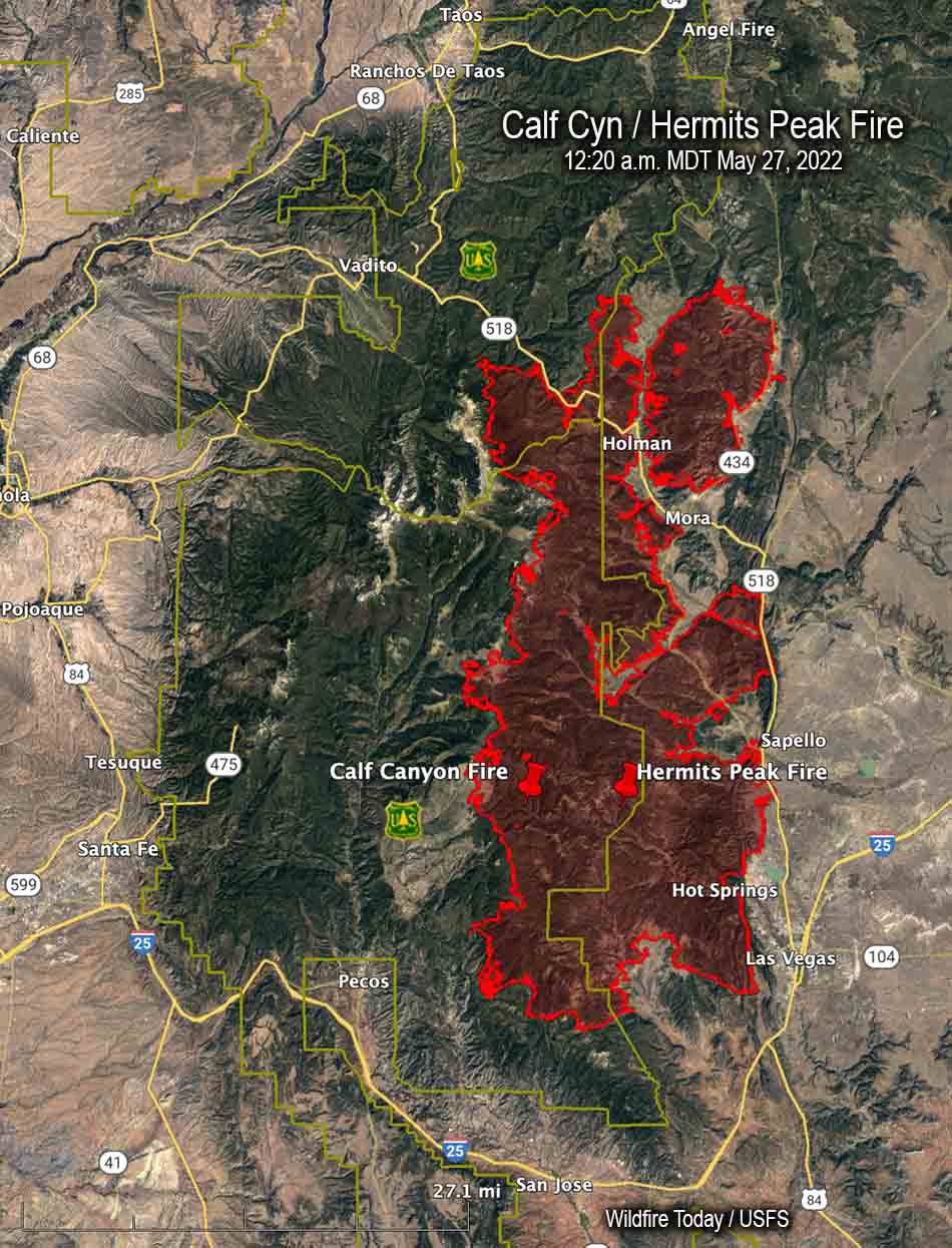
The current 341,735-acre Calf Canyon / Hermits Peak Fire is the result of two prescribed fires that escaped control earlier this year on the Santa Fe National Forest. One was a broadcast burn that crossed control lines during strong winds. The other originated from slash piles that were ignited in late January that continued burning for months. In mid-April one or more of those piles became very active during strong winds and merged with the other escaped fire on April 22. The fire has destroyed at least 400 homes, forced up to 18,000 people to evacuate their properties, and cost more than $248 million in firefighting expenses.
In 2018 another pile burning project on the Santa Fe escaped months after it was ignited and had to be converted to a wildfire. A Facilitated Learning Analysis found that “communication” and “prescribed fire preparation and risk” were common themes.
The Commissioners voted unanimously Tuesday for the USFS to go through the EIS procedure, which takes much longer than an EA and can be a costly process.
“Unacceptable risks are taken by personnel conducting planned burns because they are pressured to accomplish the mission,” the resolution states. “An EIS is appropriate because the EA … did not disclose or analyze the significant impacts to resources of an escaped intentional burn resulting from global heating and increased fine fuels.”
The resolution Requests the USFS cease all prescribed burns on the proposed project area “until the greater understanding and concomitant risk reduction provided by these reviews is in place.”
Wildfire acts as an all-spectrum ecological catalyst. Good prescribed burns will do the same thing.
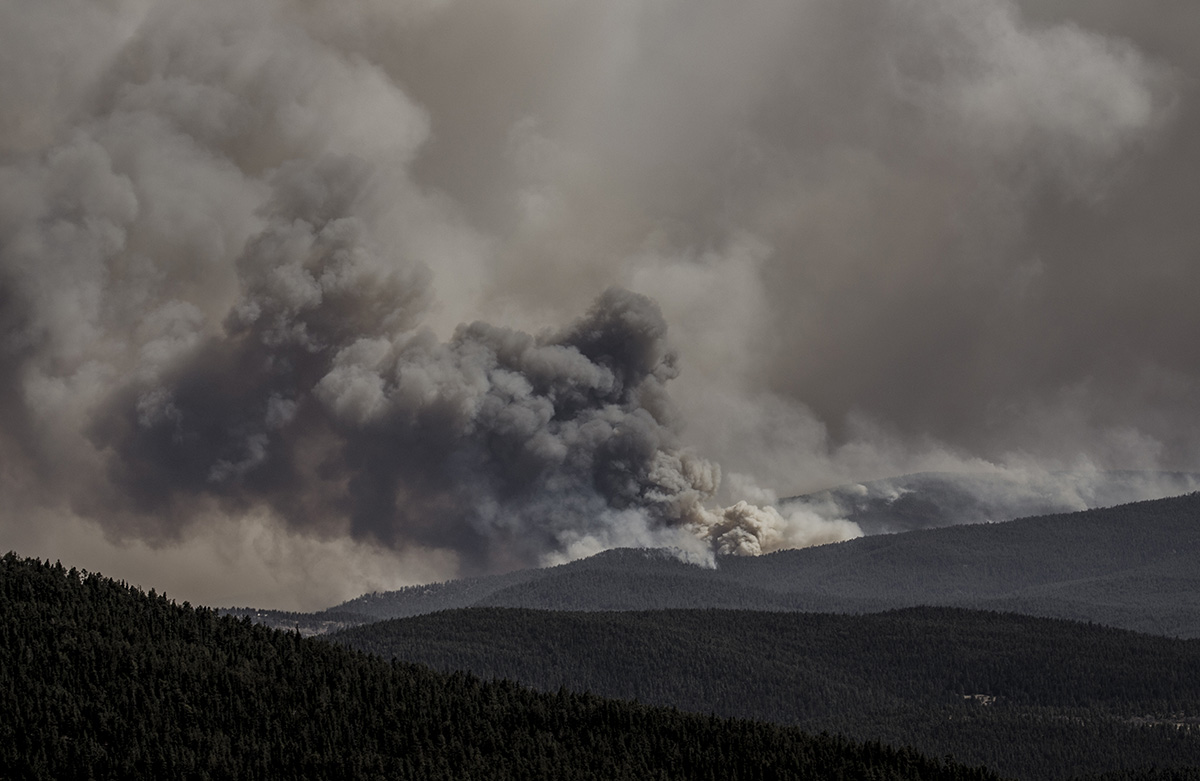
Hermit’s Peak Fire, as seen from Holman Hill in Mora County, NM April 30, 2022. Photo by Jim O’Donnell.
By Steve Pyne
We know now that the largest recorded fire in New Mexico history was started by an escaped “prescribed burn,” or rather by two. The Hermit’s Peak fire bolted away on April 6 when unexpectedly gusty winds blew sparks beyond control lines.
Then the Calf Canyon fire raced off on April 9 when similar winds fanned embers in burn piles first kindled in January. The two fires soon merged. Together, as of June 12, they have scorched 320,333 acres, with two-thirds of the fire perimeter regarded as contained.
New Mexico Gov. Michelle Lujan Grisham’s reaction was to insist that federal agencies reconsider their policy on spring burns. The chief of the U.S. Forest Service, Randy Moore, responded by announcing a halt on prescribed burning for a 90-day review period.
Inevitably, the blowups invited comparison to the 2000 Cerro Grande fire in New Mexico that began as a prescribed burn, then blew out of Bandelier National Monument and into Los Alamos. It was the largest chronicled fire in the state’s history — until now.
Prescribed fire is not likely to be challenged in principle. Recognition seems widespread that controlled burning is a legitimate source of good fire that can reduce the threat from areas likely to burn. States from Florida to California have even reformed liability law to encourage burning on private lands.
The real threat to fire management is death by a thousand cuts, each breakdown leading to shutdowns, each partisan group extracting a concession, that together so encumber the practice that it can’t be implemented. There is always something that can cause a prescribed burn to be shuttered. There is no equivalent mechanism to make up the loss.
It’s not news that the Western fire scene has become complicated. The early 20th century days, when one response — extinguish by 10 am the next morning — was adequate, are long past. It was a marvelous administrative stroke: No confusion, no compromise, one size fits all.
But it made the fire scene worse by encouraging ecological rot and an incendiary buildup of fuels. The change in policy was clear and necessary: Fire is inevitable, and we need to manage it.
Today, all aspects of landscape fire are plural. Fire control does not mean one thing; it embraces many strategies. It might refer to protecting towns or sage grouse habitat. It can resemble urban firefighting, or for reasons of safety, cost and environmental health, it could mean containing fires within broad borders.
It varies from extinguishing an abandoned campfire to herding mega-fires rolling over the Continental Divide. It might involve bulldozing around municipal watersheds, or working-with-nature firelines in wilderness.It might mean setting emergency backfires that can resemble a prescribed fire done under urgent conditions..
So, also, with prescribed burning. It might mean burning logging slash or piled cuttings from thinning operations. Or it might refer to broadcast burns that range freely over areas from an acre to a landscape. It can mean burning to improve forage in tallgrass prairie, to prune pine savannas, or to promote habitat for Karner blue butterflies.
Wildfire acts as an all-spectrum ecological catalyst. Good prescribed burns will do the same thing.
The choice isn’t between one strategy or the other; it’s selecting from a variety of techniques that work in particular settings and seasons. We need them all, not least because each strategy by itself can fail.
Fires escape initial suppression at a rate of 2-3 percent. Prescribed fires escape at a rate of 1.5 percent for the National Park Service, or less than 1 percent according to Forest Service records. Managing naturally caused fires has a similar rate of failure. When an escape occurs, however, its destructiveness makes news.
Those figures are not likely to drop. We can’t control the setting of a wildland fire as we can a blowtorch. All we can do is juggle strategies so that each strategy’s strengths fill the others’ weaknesses.The 2000 blowout in New Mexico made prescribed burning more difficult but led to a National Fire Plan. Twenty years later, the fire scene has grown bigger, meaner, tougher. The Hermits Peak fire will likely end up an order of magnitude larger than Cerro Grande.
Inevitably, our future holds a lot of fire. The goal is always to find and employ the right mix of fire for the land.
Steve Pyne is a contributor to Writers on the Range, a nonprofit dedicated to spurring lively conversation about the West. He is a fire historian, urban farmer, and author of The Pyrocene.
It later merged with the Hermits Peak Fire northwest of Las Vegas, New Mexico
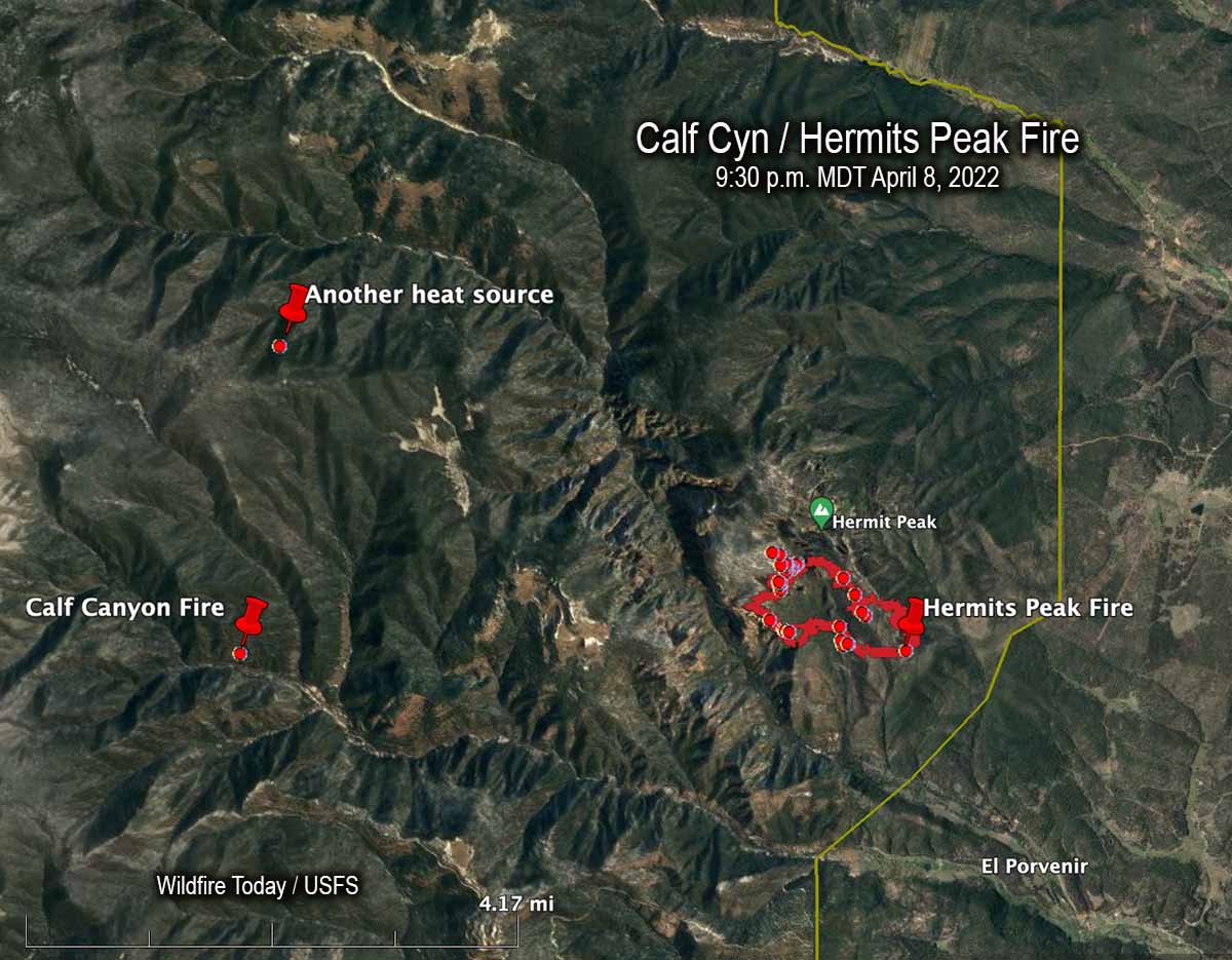
An April 8, 2022 map showing the Calf Canyon Fire before it grew large, another heat source nearby, and the Hermits Peak Fire.
The US Forest Service announced today that the Calf Canyon Fire northwest of Las Vegas, New Mexico was caused by piles that were still burning more than two months after they were ignited near the end of January, 2022. The heat remained after having been at times under snow when it was detected on April 9. The piles were comprised of vegetation and debris remaining after a fuel treatment project.
A statement released by the Santa Fe National Forest indicated that crews constructed a fireline around the 1.5-acre blaze on April 9 and “…continued to monitor the fire over the next couple of days to ensure there were no signs of heat or flames near the edge. Ten days later,” the statement continued, “on April 19 the Calf Canyon Fire reignited and escaped containment lines. A wind event on April 22 caused significant fire spread, and the Calf Canyon Fire merged with the Hermits Peak Fire, which was caused by an escaped prescribed burn.”
The term “reignited” is misleading. The burning piles were never completely put out. Wildfire Today found records showing that on April 8 fixed wing aircraft with thermal heat sensors began mapping the Hermits Peak Fire nearly every night the rest of the month. From imagery on April 8 at 9:30 p.m. MDT the Infrared Analyst noted two small heat sources both about 4 miles from the fire, one to the northwest and another almost due west which later became the Calf Canyon Fire. The heat to the northwest, 2.7 miles north of the Calf Canyon Fire, was not detected in subsequent mapping flights, indicating that it went out on its own or was successfully suppressed by firefighters.
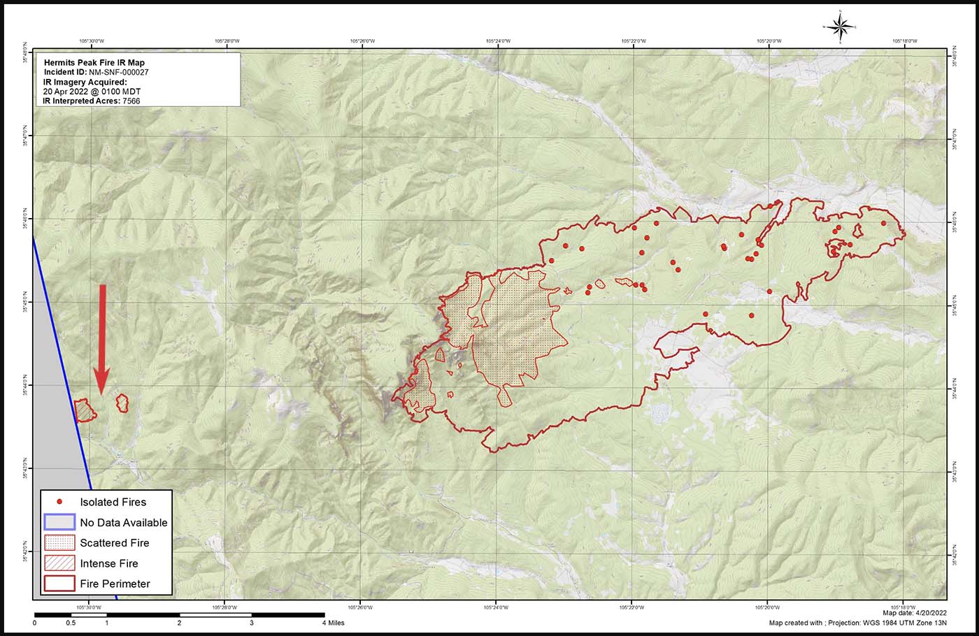
Map of the Calf Canyon and Hermits Peak Fires at 1 a.m. April 20, 2022 by the Incident Management Team. The red arrow, added by Wildfire Today, points to the Calf Canyon Fire which may have spotted, or there was an additional burn pile that spread.
Here are the results, related to what became the Calf Canyon Fire, of the Hermits Peak Fire aerial fire mapping from April 8 through April 21, 2022 (times are CDT):
8 @ 9:30 p.m.: heat noted at the pile burning site
9: (firefighters constructed line around a 1.5-acre fire spreading at the pile burning site)
10 @ 3 a.m.: heat noted
10 @ 10 p.m.: mapping mission unable to be filled (UTF)
11 @ 8:45: heat noted
13 @ 2 a.m.: not noted
13 @ 7:30 p.m.: not noted
14 @ 8:15 p.m.: not noted
15 @ 7:30 p.m.: not noted
16 @ 10 p.m.: UTF
18 @ 1:45 a.m.: not noted
18 @ 10 p.m.: UTF
20 @ 1 a.m.: intense heat noted at two locations at the pile burning site which were separately mapped by the Infrared Analyst. (See the map above. Either the fire spotted about 0.4 miles out ahead, or a second area in the pile burning project began spreading)
21 @ 1:30 a.m.: had grown to about 220 acres; was approximately half a mile wide and one mile long)
It is unknown if the mapping mission each night included the pile burning site four miles west of the Hermits Peak Fire, or if the Infrared Analyst was careful to examine the imagery for small detections of heat at the pile burning site.
After April 20 the Calf Canyon Fire was large and merged with the Hermits Peak Fire on the 22ndwhen both fires blew up. At that time the Hermits Peak fire was nearly contained and had been relatively quiet for several days, but pushed by very strong winds both fires ran 11 miles to the northwest in narrow parallel footprints until the wind speed decreased, allowing the flanks of both fires to spread laterally until they merged. The winds monitored at a weather station that day near Las Vegas, NM recorded sustained speeds of 40 to 50 mph with gusts up to 67 while the relative humidity dropped as low as 6 percent.
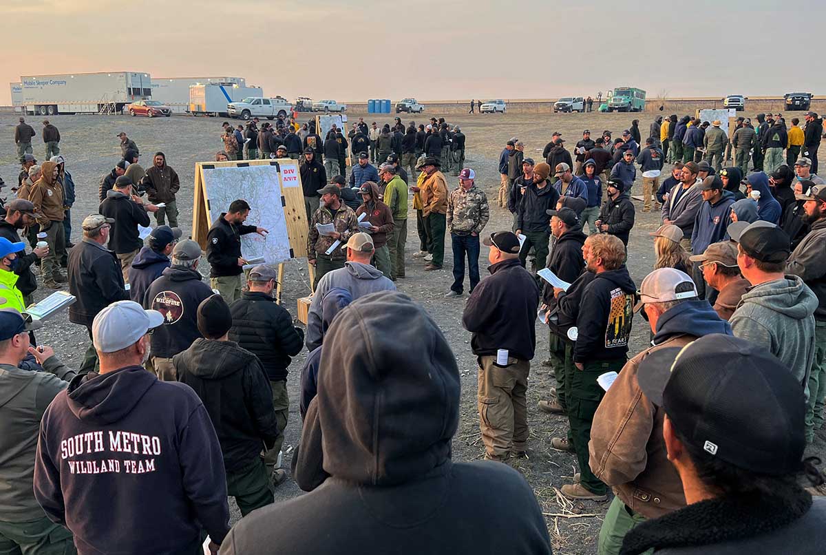
“We don’t have enough resources to do everything we want to do at one time so we have to prioritize the resources we have at the right location,” said Incident Commander Carl Schwope in a briefing on April 23.
The two merged fires, both the result of escaped prescribed fires and now called Calf Canyon / Hermits Peak Fire, are now 17 miles wide, 45 miles long, and have burned more than 312,000 acres, about 1/3 the size of Rhode Island. If you were driving from the south end of the fire at Las Vegas, NM on Highway 518 going north, it would take about an hour to reach the north edge of the fire near Angostura.
Morning briefing May 8, 2022 on the Calf Canyon – Hermits Peak Fire as firefighters break out into Divisions. The Hermits Peak Fire started from an escaped prescribed fire on April 6, 2022. USFS photo.
The US Forest Service announced May 20 in a press release that a “pause” is in effect for all prescribed fire operations on National Forest System lands. The reason given for the pause is “because of the current extreme wildfire risk conditions in the field…while we conduct a 90-day review of protocols, decision support tools, and practices ahead of planned operations this fall,” Forest Service Chief Randy Moore said in the statement released late Friday afternoon.
The public statement from Chief Moore does not actually say in clear text why the review is being conducted, but the unmentioned elephant in the press release is the hundreds of thousands of acres burning and the weeks-long evacuation orders in New Mexico, some of it attributed to an escaped prescribed fire. However in an email sent to FS employees, the Chief wrote, “I’m sure you all have seen the stories in the news about recent prescribed burn escapes. These, as well as isolated incidents on other national forests in recent years, have made it imperative that we pause to review our processes. That’s why I am temporarily halting all prescribed burns on National Forest System lands and creating a review team consisting of representatives from the wildland fire and research community.”
At least two prescribed fires escaped in New Mexico in April. The Hermits Peak Fire escaped from the Las Dispensas prescribed fire northwest of Las Vegas on April 6. On April 22 it merged with the Calf Canyon Fire which was reported April 19 in the general area where another prescribed fire was ignited about three months earlier. Now a month after the Calf Canyon Fire was reported the FS is saying its cause is still under investigation.
The combined Hermits Peak / Calf Canyon Fire is still spreading. It has burned more than 303,000 acres and destroyed 347 homes and 287 other structures. Another 16,316 structures are threatened and evacuations are still in effect. An estimated $95 million has been spent so far on suppression of the fire.
On April 7 a prescribed fire being conducted by the Bureau of Land Management about 10 miles southeast of Roswell, NM escaped and burned 1,900 acres.
On the Dixie National Forest in Utah the Left Fork Fire was reported May 9. On May 10 the Forest Service said it ignited from material still burning from a prescribed fire conducted April 7, 2022. On May 11, 12, and 13 the daily updates on the wildfire posted by the Dixie National Forest stated it was “human caused.” The escaped fire burned 97 acres.
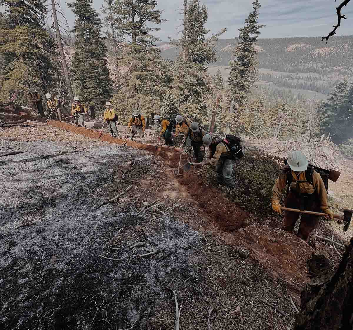
Firefighters construct fireline on the Left Fork Fire in Utah which was caused by an escaped prescribed fire. Posted by the Dixie NF, May 12, 2022. Photo by Mervin Garcia, Engine 322.
On May 16 the Uncompahgre & Gunnison National Forests ignited the Simms Mesa prescribed fire, expected to treat 200 acres about 11 miles south of Montrose, Colorado. On May 19 a wildfire was reported in the area which was was given the name “Simms Fire”. Officially the cause is under investigation, but the Forest Service on May 19 wrote about the fire on Facebook, “Earlier in the week a prescribed burn was conducted in the vicinity which was monitored daily. The cause of the fire is under investigation.” Fire officials report that at least one home has been destroyed. Evacuations are in effect and Rocky Mountain Incident Management Team 1 has been mobilized. Friday morning it had burned 371 acres.
“In 99.84 percent of cases, prescribed fires go as planned,” the statement from Chief Moore said. “In rare circumstances, conditions change, and prescribed burns move outside the planned project area and become wildfires. The review I am announcing today will task representatives from across the wildland fire and research community with conducting the national review and evaluating the prescribed fire program, from the best available science to on-the-ground implementation. Lessons learned and any resulting program improvements will be in place prior to resuming prescribed burning.”
The FS safely conducts about 4,500 prescribed fire projects each year on average, treating more than 1.4 million acres. Since most prescribed fires are conducted between September and May, the Forest Service expects the pause will have “minimal impact” on their goal of increasing fuels treatments by up to four times the current levels in the West, including using prescribed burning as well as mechanical and other treatments.
Issuing a press release late on a Friday afternoon at the end of the work week is a tactic sometimes chosen in hopes that the timing of the unfavorable information will minimize its negative impact.
Inciweb currently lists nine prescribed fire projects on Forest Service lands in various stages of planning or execution; there are likely more, since not all are entered at the website.
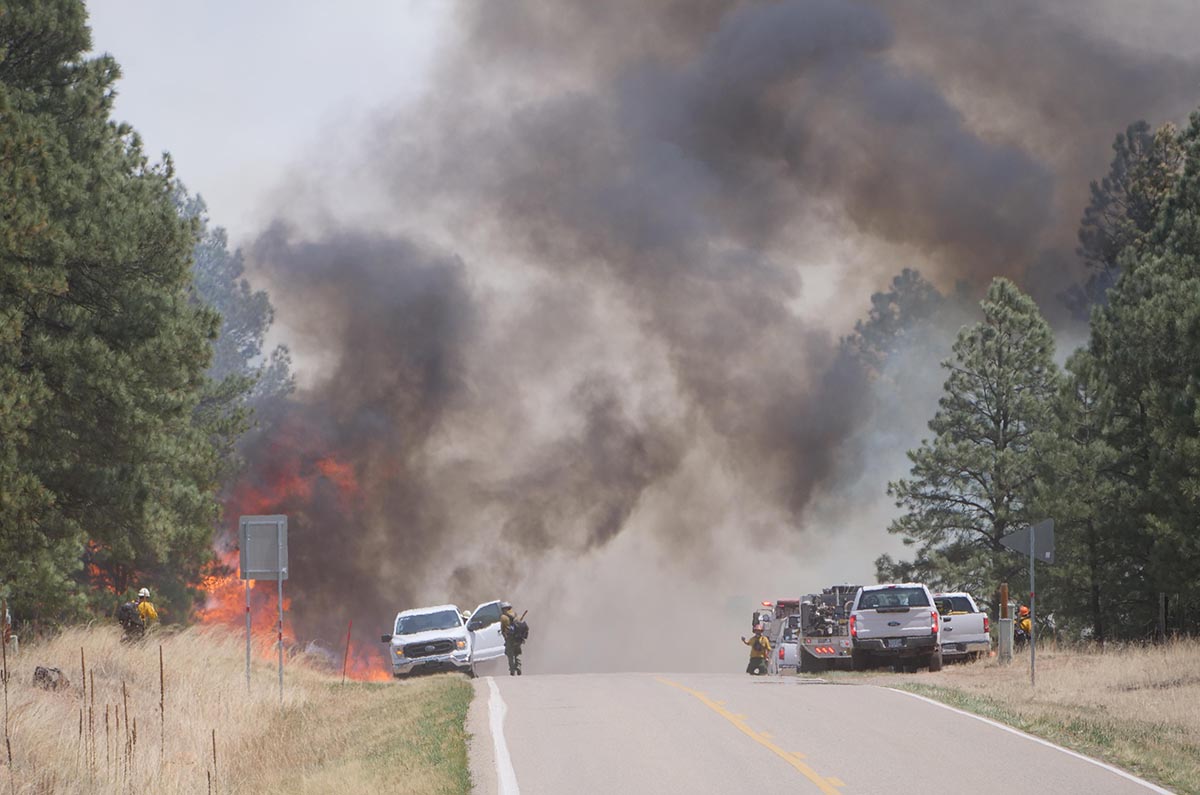
Firefighters attempt to hold the Calf Canyon -Hermits Peak Fire at Highway 434, May 10, 2022. Inciweb.
There is very little fire history out in front of the Calf Canyon – Hermits Peak Fire in Northern New Mexico
9:09 p.m. MDT May 13, 2022
About three months before the Calf Canyon Fire was reported April 19, 2022, employees of the Santa Fe National Forest ignited hundreds of acres of debris piles which were created during fuels treatment projects. The piles were “approximately 17 miles west of Las Vegas,” according to a notice posted at the New Mexico Fire Information website on January 26, 2022. (See below) The name of the project was Gallinas Canyon wildland-urban interface (WUI) prescribed pile burn. In January prior to the notice crews had already completed 266 acres of the 374-acre unit and planned to continue burning more piles “as early as January 27.”
Fires are usually named after a geographical feature near the point of origin. Calf Canyon Road intersects with Forest Road 263 which is in Gallinas Canyon.
On September 27, 2012 a 300-acre hazardous fuels reduction mechanical thinning project was finished just north of Calf Canyon Road, which likely left hundreds of piles to burn later.
This project and Calf Canyon Road are broadly within the general area where the Calf Canyon Fire started. There have also been other fuels treatment projects in that area over the last 10 years.
To see all articles on Wildfire Today about the Calf Canyon and Hermits Peak Fires, including the most recent, click here.
The US Forest Service has already identified an escaped prescribed fire as the cause of the Hermits Peak Fire, but lists the cause of the Calf Canyon Fire as under investigation.
Wildfires, prescribed fires, and pile burns are known to have smoldered for months, sometimes under snow and through an entire winter, before being discovered months later when smoke becomes visible. The burn piles were at approximately 8,000 feet, so the snow reported in the notice may have kept the vegetation cold and wet for a couple of months if the pile burning was completed in February. We are not saying that is what caused the Calf Canyon Fire, but investigators have no doubt evaluated that possibility and ruled it in or out.
Three days after the Calf Canyon Fire was reported strong winds and low humidities combined to caused it to merge with the Hermits Peak Fire and spread 10 miles to the northeast through dry vegetation in a 24-hour period.
What is next for the Calf Canyon / Hermits Peak Fire?
Fire history map, Calf Canyon – Hermits Peak Fire May 12, 2022.
While the Calf Canyon / Hermits Peak Fire has been churning through more than 270,000 acres on its march to the north, at least 90 percent of those acres have burned in areas with no recorded history of previous fires in the national database, going back decades. If that spread to the north and north-northeast continues there is limited significant fire scars in the records out ahead that will slow the fire. (Update May 14, 2022: The NIFC database does not include two fires north of the Calf Canyon / Hermits Peak Fire; the 2020 Luna Fire (10,100 acres) and the 2018 Sardinas Canyon Fire (2,300 acres), according to the link provided in a comment by SE.)
The overall length of the fire is 45 miles as of Thursday night May 12. From the origins they ran north for 32 miles, and south for 13.
There are also no large completed fuel treatment projects in the national database north of the fire that could serve as barriers, except for several near US Highway 64 west of Angel Fire near Valle Escondido 14 miles away. But there are other fuels treatment projects at what is now the southeast corner of the fire in the Barillas Peak area. It has just started to burn into the 2,534-acre “Wildfire Commissary 2015” fire use fire, but it is possible that without too much trouble it could work its way around it, another smaller fire use incident, and a 600-acre prescribed fire conducted in 2004.
At the end of the day on May 12 the north end of the fire was 14 miles from US 64, 19 miles from Taos, 11 miles from the Cooks Peak Fire, and 25 miles from the Philmont Scout Ranch.
Hermits Peak Fire, the morning of April 10, 2022. USFS photo.
Information released from the Incident Management Team for the Hermits Peak Fire at approximately 1:30 p.m. MDT on Sunday, stated that voluntary evacuations are in effect for three communities:
In coordination with the San Miguel County Sheriff’s Office, voluntary evacuations for the communities of San Ignacio, Las Dispensas and Pendaries have been put in place. Forecasted winds exceeding 60 mph have been predicted for today. Increasing winds each day through next week can cause holding concerns, drier weather is forecasted into next week and a RED FLAG WARNING is in effect for the fire area today until 8 pm.
The Incident Management Teams will continue using full suppression strategy utilizing hand crews and assessing the best strategy to engage the fire during the high wind period. The Hermits Peak Fire is in steep, rugged, terrain with limited access by vehicle. Firefighters are working to keep the fire out of Beaver Creek and out of the Gallinas Municipal Watershed.
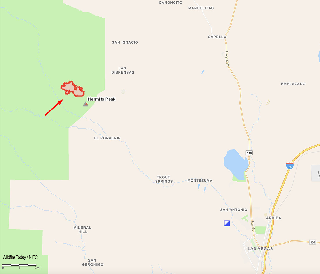
Unofficial map of the Hermits Peak Fire area showing the communities of San Ignacio, Las Dispensas and Pendaries.
Early Sunday morning the fire was about 12 miles northwest of Las Vegas, New Mexico and according to the US Forest Service had burned 540 acres.
To see all articles about the Hermits Peak Fire on Wildfire Today, including the most recent, click HERE.
A Type 2 Incident Management Team, Southwest Team 4 with Incident Commander Aaron Hulburd, will assume command on Monday, April 11.
On Sunday resources assigned to the fire included 4 hotshot crews, 1 Type 2 IA crew, 8 fire engines, 1 Type 1 helicopter, 1 Type 2 helicopter, 1 Type 3 helicopter, 1 Rapid Extraction Module, and 1 Tactical Water Tender, for a total of 163 personnel.
Updated 12:05 p.m. MDT April 10, 2022
Map showing the location of the Hermits Peak Fire at 8:30 a.m. MDT April 10, 2022.
Hermits Peak Fire
Most of the Hermits Peak Fire in the Santa Fe National Forest 12 miles northwest of Las Vegas, New Mexico is spreading in the Pecos Wilderness. While the transition is occurring from the Type 3 Incident Management Team to the incoming Type 2 Team very little current information is available. An unofficial estimate of the size after a mapping flight early Sunday morning puts it at more than 500 acres.
The weather will challenge firefighters for the next several days, with looming Red Flag Warnings Sunday and Monday and a Fire Weather Watch on Tuesday. The spot weather forecast for Sunday is for 10 to 14 percent relative humidity, an unstable atmosphere, the possibility of erratic, downburst winds, and general 22 to 30 mph winds gusting in the afternoon out of the west to 60 mph along ridges. Strong winds and low humidities will continue Sunday night and Monday. A longer range forecast predicts strong winds and low humidities persisting into Saturday, April 15.
The Incident Management Team said the fire could potentially spread in all directions on Sunday due to the predicted wind and topography.
The Hermits Peak Fire is a result of the Las Dispensas prescribed fire spreading out of control at 4:30 p.m. on April 6.
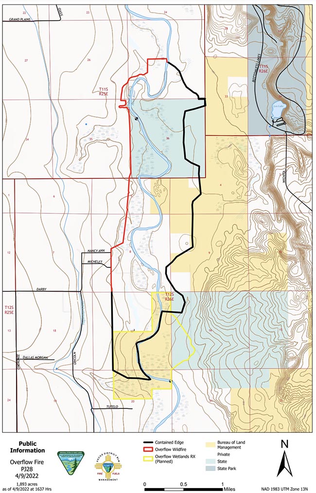
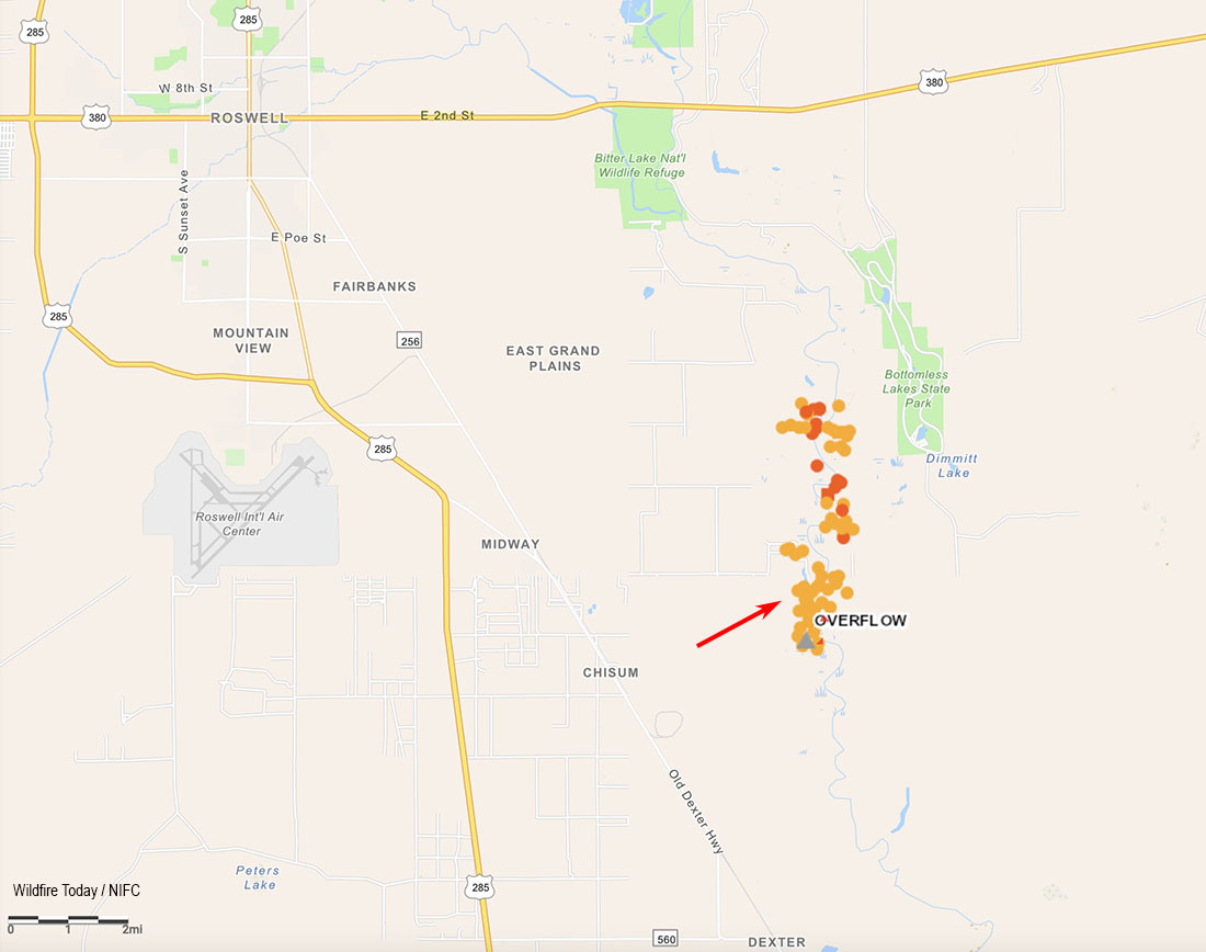
Overflow Fire
Another escaped prescribed fire, the Overflow Fire 10 miles southeast of Roswell, New Mexico, is burning in lighter fuels than the Hermits Peak Fire. Sunday morning it is still listed at 1,900 acres as the firefighters move into the mopup phase. Resources for the fire Sunday include five engines, two hotshot crews, and one bulldozer. Air support resources remain on standby.
Map of the Overflow Fire, April 9, 2022. BLM.
A Red Flag Warning is in effect Sunday in Southeast New Mexico due to expected strong winds and low relative humidity. Monday’s forecast predicts similar conditions, with the Red Flag Warning remaining in place.
12:04 MDT April 9, 2022
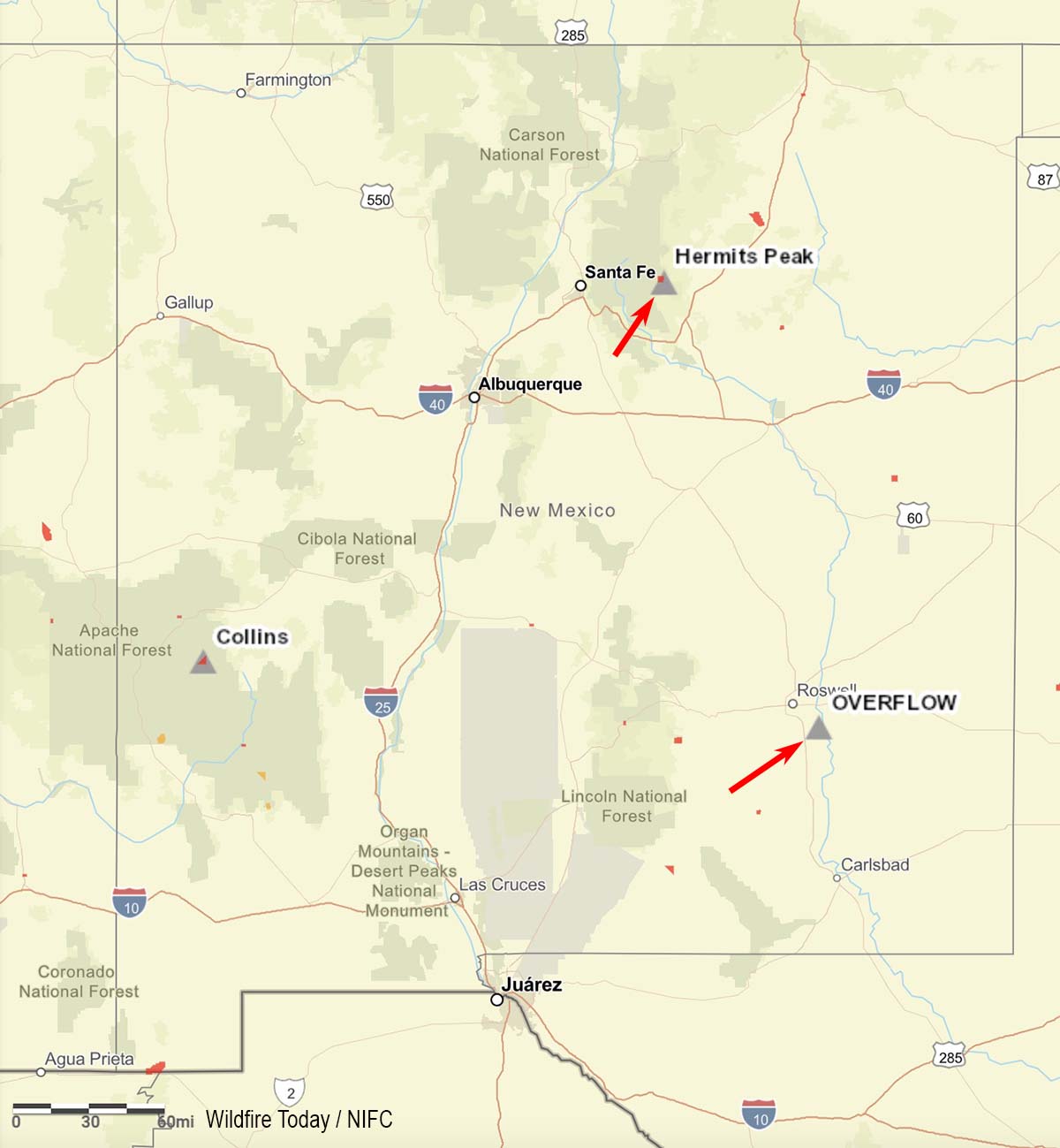
Map showing location of two escaped prescribed fires in New Mexico (at the red arrows).
Two prescribed fire projects in New Mexico have escaped and were declared as wildfires.
Hermits Peak
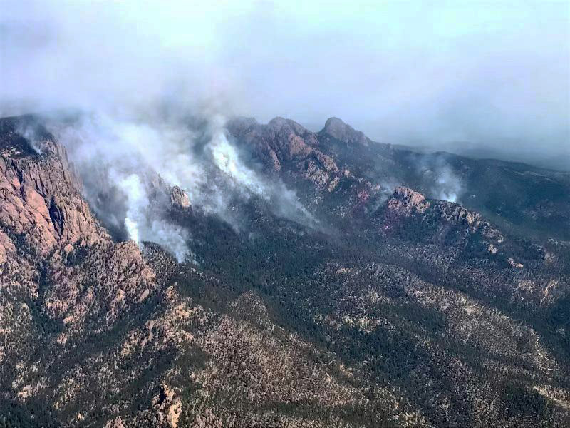
The Hermits Peak Fire on the Santa Fe National Forest is 29 miles east of Santa Fe and 12 miles northwest of Las Vegas, New Mexico. It escaped from the Las Dispensas prescribed fire at 4:30 p.m. on April 6 after the project was ignited late that morning. On Friday the U.S. Forest Service said it had burned approximately 350 acres after having been declared a wildfire. It is burning in mixed conifer in steep, rugged terrain. A Type 3 Incident Management Team assumed command on April 8 with the objective of full suppression. A Type 2 IMT, Southwest Team 4 with Incident Commander Aaron Hulburd, has been ordered and will inbrief at 9 a.m. Sunday.
It is moving toward the Pecos Wilderness. As of April 8 there were no direct threats to private property.
Hermits Peak Fire, April 8, 2022. USFS photo.Map showing the location of the Hermits Peak Fire at 10 p.m. MDT April 8, 2022.
In a statement released on April 6, the U.S. Forest Service said, “Although forecasted weather conditions were within parameters for the prescribed burn, unexpected erratic winds in the late afternoon caused multiple spot fires that spread outside the project boundary.”
Overflow Fire
The Overflow Fire has burned approximately 1,900 acres of salt cedar and grass 10 miles southeast of Roswell, New Mexico. The Bureau of Land Management was conducting a prescribed fire along the Pecos River corridor in Chaves County on April 7 when, the agency said, “an unexpected fire whirl carried fire across the control lines.” It was declared a wildfire at 1:25 p.m. April 7 and the strategy is full suppression. It has spread onto Federal, State and private lands.
Map showing heat detected on the Overflow Fire by satellites as late at 2:55 p.m. MDT April 8, 2022.
As of April 8 resources on the incident included six engines, two hotshot crews, and overhead from Chaves County, Carlsbad Fire Department, Ruidoso Fire Department, New Mexico Forestry, U.S. Forest Service, and U. S. Fish and Wildlife Service.
Weather
Early in the morning on April 6 The National Weather Service said there would be strong winds across Central and Western New Mexico that day. They issued a wind advisory for “northwest and central portions of the area” in effect from 2 to 7 p.m.
Another windy day is forecast across central and western #NM with areas of blowing dust developing during the afternoon hours. A Wind Advisory is in effect from 2-7PM MDT for northwest and central portions of the area, including the #Albuquerque Metro. #nmwxpic.twitter.com/MyvOcMhoQb
The spot weather forecast for the Las Dispensas prescribed fire which became the Hermits Peak wildfire was issued at 8:54 a.m. MDT April 6, a few hours before it was ignited. It predicted clear skies, 9 to 13 percent relative humidity, and winds at 20 feet to be out of the west at 10 to 15 mph with gusts to 25 mph possible.
A spot weather forecast for the Overflow prescribed fire issued the previous evening predicted for the next day clear skies, 7 percent relative humidity, and “north winds 5 to 6 mph shifting to the south 7 to 13 mph late in the morning.”